A desert is not simply a hot place with dunes. It is a land of low precipitation, sparse plant cover, high evaporation stress, and long gaps between reliable moisture. That is why the largest desert on Earth is Antarctica, not the Sahara. It is also why a desert can be made of ice, gravel, stone, salt crust, or sand rather than one picture-book surface.
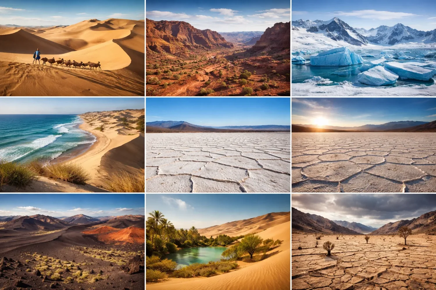
This page groups the planet’s deserts into 8 practical types: hot, cold, polar, coastal, sandy, salt, rocky, and rain shadow. Some labels describe climate. Some describe the surface. One describes the process that dries the land out. Put together, they give a far clearer map of desert landscapes than a single four-type list ever can.
What Counts as a Desert?
Most scientific descriptions set the desert line at about 250 millimeters of annual precipitation or less, though local evaporation, temperature, and seasonality matter just as much. A place can stay dry because air sinks and warms in the subtropics, because cold ocean currents choke off rainfall near a coast, or because mountain ranges strip moisture from incoming winds before that air reaches the basin beyond.
That dryness has visible results. Soils stay thin. Streams are often temporary. Plants space themselves widely. Salts can build up near the surface. Wind becomes a patient sculptor, trimming rock, moving dust, and piling sand where the ground and air flow allow it. In many deserts, the true story sits in the small details: a varnished stone, a crust of gypsum, a fog-fed beetle, a dry lake bed marked by polygons.
Area matters, too. Deserts are found on every continent and cover roughly one-fifth of Earth’s land area. In older broad dryland systems, the share rises closer to one-third when arid lands are grouped more generously. Either way, drylands occupy a vast part of the planet. They are not fringe landscapes. They are one of Earth’s main environmental zones.
A desert is defined more by water shortage than by heat. That one idea clears up two common mistakes at once: deserts are not always sandy, and they are not always hot.
Rarely does one label tell the full story. The Namib, for example, is both coastal and partly sandy. The Gobi is cold, often rocky, and shaped in part by rain shadow effects. The Atacama is coastal, strongly salt-rich in many basins, and among the driest places on Earth. Once that overlap is clear, desert classification makes far more sense.
Why Desert Types Need More Than One Lens
Different desert lists exist because they answer different questions. A climate-based list asks whether a desert is hot, cold, polar, or coastal. A surface-based list asks what you walk on: sand, gravel, bare rock, or salt crust. A process-based list asks why the dryness happens in the first place. None of these approaches is wrong. Each one catches a different part of the landscape.
That is where this 8-type model earns its keep. It combines the thermal setting, the ground surface, and the drying mechanism into one usable structure. For readers comparing deserts around the globe, it works better than narrow schoolbook categories because it shows both difference and overlap.
One more point matters. Sand dunes cover only a small share of the world’s deserts—often cited at about 10 percent. Even in the Sahara, dune fields take up only part of the whole. Vast areas are gravel plains, bedrock plateaus, basalt fields, alluvial fans, mountain fronts, or salt pans. Popular imagery keeps putting dunes in the spotlight. Field reality is rougher, stonier, and more varied.
| Type | Main Lens | What Defines It | Typical Examples |
|---|---|---|---|
| Hot Desert | Climate | High heat, strong evaporation, usually in subtropical belts | Sahara, Arabian, Sonoran |
| Cold Desert | Climate | Dry conditions with cold winters, common in interiors and uplands | Gobi, Great Basin, Patagonian margins |
| Polar Desert | Climate | Very low precipitation in polar regions, often as snow | Antarctica, Arctic polar deserts |
| Coastal Desert | Climate | Ocean-edge aridity tied to cold currents, fog, and temperature inversion | Namib, Atacama, Peruvian coast |
| Sandy Desert | Surface | Dune fields, sand seas, loose aeolian sand | Rub’ al Khali, Erg Chebbi, Simpson |
| Salt Desert | Surface | Salt flats, playas, sabkhas, evaporite crusts in closed basins | Salar de Uyuni, Bonneville Salt Flats, Salar de Atacama |
| Rocky Desert | Surface | Stone plains, reg, hamada, desert pavement, exposed bedrock | Much of the Sahara, parts of the Gobi, Arabian rock plateaus |
| Rain Shadow Desert | Process | Dryness on the leeward side of mountain barriers | Great Basin, Patagonia, Taklamakan |
So when people ask, “How many types of deserts are there?” the most honest answer is this: it depends on what you are measuring. For a global reference page, these eight types cover the main terrain readers actually meet on maps and in the field.
How the 8 Desert Types Fit Together
Hot, cold, polar, and coastal deserts tell you about climate. Sandy, salt, and rocky deserts tell you about surface character. Rain shadow deserts tell you about cause. That means a single desert may belong to two or even three types at once.
The overlap matters because it shapes water, soil, and life. A coastal desert with regular fog can support organisms that barely touch rainfall. A salt desert can stay mostly barren even where shallow groundwater is present, because the water is too saline for most plants. A rocky desert may warm fast by day, cool fast by night, and shed what little rain it receives downslope toward a playa or wadi.
- Ask how dry it is.
- Ask why it is dry.
- Ask what covers the ground.
- Then ask where the rare moisture goes.
Across many deserts runs the same rule: water arrives rarely, leaves fast, and shapes everything while it is there. In a dune sea, it can sink. On a rock plateau, it runs off. In a closed salt basin, it evaporates and leaves minerals behind. In a polar desert, it may be locked as snow and ice for long stretches, which still counts as aridity because liquid water remains scarce.
Desert Climate Codes and Technical Markers
If you want a more technical reading, desert types also connect to climate codes, basin geometry, and surface process terms. In the Köppen system, many hot deserts fall under BWh, the hot desert climate, while many cold deserts fall under BWk, the cold desert climate. That distinction matters because two places can be equally dry in annual terms yet feel entirely different in winter, in soil temperature, and in the growing season they allow.
Coastal deserts often complicate the picture in a useful way. Some occur in low latitudes, yet cold currents keep mean temperatures lower than many readers expect. The lower air stays cool, fog forms, and the climate may edge toward BWk-like thermal behavior even at subtropical latitudes. Polar deserts usually sit outside the standard BW logic because the polar temperature regime becomes its own controlling class. In plain terms, the air is so cold that the polar signal takes over, even while the moisture signal still says desert.
Another technical marker is potential evapotranspiration. Two deserts with similar rainfall totals may not operate the same way if one has much higher evaporative demand. A hot subtropical basin can lose water almost as soon as it arrives. A cold interior basin may keep snow cover or frozen soil longer, changing infiltration and runoff timing even with a similarly small annual moisture budget. This is one reason dryland scientists do not rely on rainfall alone.
Drainage type matters as well. Many deserts sit in endorheic basins, where water does not flow to the sea. Instead it collects in temporary lakes, marshes, salars, or playas and then evaporates. Endorheic settings are especially common in cold deserts, rain shadow deserts, and salt deserts. They are one of the clearest links between mountain uplift, basin shape, and mineral-rich dryland surfaces.
| Technical Marker | What It Tells You | Most Useful For |
|---|---|---|
| BWh | Hot desert climate with strong heat and very low rainfall | Subtropical hot deserts such as the Sahara or Arabian Desert |
| BWk | Cold desert climate with low rainfall and cooler annual temperature | Gobi, Great Basin, many interior upland deserts |
| Potential Evapotranspiration | How strongly climate pulls moisture back into the atmosphere | Comparing hot and cold deserts with similar rainfall totals |
| Endorheic Basin | Closed drainage basin with no outlet to the ocean | Playas, salars, dry lakes, saline flats |
| Thermal Inversion | Cool air trapped below warmer air, limiting rainfall | Coastal deserts influenced by cold currents |
| Deflation Surface | Ground left coarse after wind strips away finer particles | Rocky deserts, gravel plains, desert pavement |
These markers do not replace the 8-type system. They sharpen it. A reader can say the Namib is a coastal desert, then add that fog and inversion are central to its dryness. The Great Basin can be called a cold desert, then read more precisely as a rain shadow region with internal drainage and many saline basin floors. Technical language, used lightly, helps the map come into focus.
Hot Deserts
Hot deserts are the classic image most people carry around—broad dry lands under fierce sun, thin cloud cover, and large day-to-night temperature swings. Many sit in the belt between roughly 15° and 30° latitude, where descending air in the subtropics suppresses cloud growth and rainfall. That is why the Sahara, the Arabian Desert, much of inland Australia, and parts of the deserts of North America all line up in similar latitude bands.
Heat alone does not make them deserts. The deeper reason is a lasting moisture deficit. Air sinks, warms, and dries. Skies stay clear. Solar radiation strikes the surface hard. Where water is present, evaporation is rapid. In places such as the Sahara, with an area around 8.6 million square kilometers, this creates a landscape of hamadas, regs, dunes, dry valleys, gravel plains, and scattered oases rather than one endless field of sand.
Plants in hot deserts solve the water problem in a few repeatable ways. Some avoid drought with short life cycles, germinating after brief rain and setting seed quickly. Some reduce water loss through tiny leaves, waxy surfaces, deep taproots, or swollen tissues. Others spread roots near the surface to grab a fast-moving pulse of water before it disappears. The details change by continent. The rule stays the same.
Animal life follows the same logic. Many species become nocturnal. Burrowing helps. Pale coloring reflects light. Long limbs lift the body above hot ground. In hot deserts of the Americas, reptiles and small mammals dominate many food webs. In Africa and Arabia, larger mammals use broad ranges, travel corridors, and water memory. Every creature pays attention to shade, timing, and the cost of movement.
Ground forms vary more than many readers expect. Some hot deserts are gravelly. Some are rock-dominated. Some hold major dune systems. The Rub’ al Khali, at about 650,000 square kilometers, is the world’s largest uninterrupted sand desert. By contrast, large parts of the Sahara are stone plains or exposed bedrock. Heat, then, describes the climate setting. It does not tell you what the surface will look like.
If you want a closer regional breakdown, see hot deserts of the world. It pairs well with this section because hot deserts are the easiest type to picture and the easiest type to oversimplify.
What Usually Marks a Hot Desert
- Very low rainfall, often below 250 mm each year
- High evaporation demand and intense solar heating
- Wide temperature swings, especially where humidity is very low
- Sparse plant cover broken by wadis, fans, or oasis zones
- Mixed surfaces of stone, gravel, sand, and dry basins
Examples That Show the Range
Sahara: the largest hot desert, with dune seas, rock plateaus, gravel plains, mountains, and dry basins all in one system.
Arabian Desert: a vast desert region with major sand bodies, limestone plateaus, escarpments, and dry channels.
Sonoran Desert: a hot desert with more seasonal rainfall than the Sahara and richer plant structure in many zones, including iconic cactus landscapes.
Cold Deserts
Cold deserts stay dry like hot deserts, yet their annual rhythm is very different. Winters can be severe. Snow may fall, though totals are often low. Summer warmth may still be strong by day, especially in continental interiors. The result is a landscape where aridity and cold stress operate together.
The Gobi Desert is the most familiar example. It is often described as a cold desert because it lies deep in the Asian interior, far from ocean moisture, and partly within the rain shadow of major mountain systems. In the Gobi, annual precipitation ranges from under 50 mm in the driest western sectors to just over 200 mm in wetter northeastern margins. Temperatures can drop to around -40°C in winter and climb toward 45°C in summer. Few desert labels capture that swing as sharply as “cold desert.”
Cold deserts often occupy basins, plateaus, and uplands where the atmosphere is dry and continental. The Great Basin in North America covers about 492,000 square kilometers and is famous for internal drainage, basin-and-range relief, and broad salt playas. Many valleys receive only about 150 to 300 mm of precipitation a year. That amount is enough for shrubs, grasses, and seasonal growth in some years, yet far too little for dense cover.
Because winter cold slows biological activity, the look of a cold desert can be quieter and more open than that of some hot deserts. Shrublands dominate many sectors. Sagebrush, saltbush, saxaul, and low grasses often matter more than tall succulents. Soil crusts can be important. So can freeze-thaw action, which sorts gravel, cracks surface layers, and changes runoff patterns after snowmelt or cold rain.
For animals, survival depends on flexibility. Insulation matters. Seasonal movement matters. So does the ability to use burrows, rock shelter, or patchy forage over large areas. A cold desert is not empty. It simply works on a tighter moisture budget and a harsher thermal schedule. Quiet country, often. Never simple country.
For a fuller regional treatment, visit cold deserts of the world. It helps separate true cold-arid systems from places that are merely chilly, dry grasslands.
Why Cold Deserts Matter in Desert Classification
They break the old myth that heat defines desert. A landscape can be deeply dry, thinly vegetated, and strongly desert-like while spending much of the year below freezing. That single fact changes how readers understand the Gobi, the Great Basin, high Andean basins, and many interior plateaus.
Polar Deserts
Polar deserts take the idea of dryness into its coldest form. They occur where precipitation is extremely low, air is frigid, and biological productivity stays limited for long stretches of the year. Snow and ice dominate the public image, yet the desert logic is the same as elsewhere: very little precipitation, very little available liquid water, and sparse life over broad areas.
Antarctica is the clearest example. With an area of about 14.2 million square kilometers, it is the largest desert on Earth. Parts of the inland plateau average only about 50 millimeters of precipitation a year in liquid-water equivalent. That is less moisture than many hot deserts receive. The continent also holds the lowest air temperature measured at the surface, around -89.2°C at Vostok Station. Cold beyond ordinary comparison, yes. Dry beyond ordinary comparison as well.
Polar deserts are not just blank white surfaces. Ice-free sectors, nunataks, patterned ground, gravel plains, dry valleys, and wind-scoured slopes all appear in the right settings. The McMurdo Dry Valleys show this clearly: bare ground, salt accumulations, stream pulses during brief melt periods, and soils shaped by freeze-thaw and permafrost. On the Arctic side, parts of northern Greenland and high Arctic islands function as polar desert where precipitation stays very low and plant cover remains patchy.
Life in these regions depends on short windows. Mosses, lichens, microbes, and cold-tolerant invertebrates dominate the ground story. In coastal margins, seabird and marine food inputs may enrich small pockets of land. Inland, the system tightens. Nutrient cycling slows. Freeze-thaw and wind become major surface shapers. A polar desert can look still from a distance. Up close, it is full of micro-scale structure.
One reason polar deserts are often misunderstood is that people equate ice with moisture abundance. Yet frozen water locked in ice sheets does not make a place humid in ecological terms. For soils, plants, and surface weathering, available liquid water is what counts. By that measure, much of Antarctica is desert in the most exact sense.
For a wider look at frozen drylands, read polar deserts. It expands the Arctic-Antarctic contrast and shows why high-latitude aridity deserves its own class instead of being folded loosely into “cold deserts.”
Where Polar Deserts Stand Apart
- Precipitation is tiny, often snow rather than rain
- Liquid water is limited for much of the year
- Wind chill, freeze-thaw, and ice cover shape the ground
- Biological activity is concentrated in short seasonal pulses
Coastal Deserts
Coastal deserts sit beside the ocean and still remain dry. That seems odd at first glance. Yet the mechanism is well known: cold offshore currents cool the lower air, create stable temperature inversions, and favor fog and low cloud over rain. The air holds moisture, but vertical mixing stays weak, so the moisture does not build into the kind of rain-bearing cloud towers seen in warmer marine climates.
The two classic examples are the Namib and the Atacama. Along the Namib coast, the cold Benguela Current chills moist maritime air and sends frequent fog inland. Some stretches of the Namib run for more than 2,000 kilometers along southwestern Africa. Near the coast, rainfall can be close to absent, yet fog is common enough to feed beetles, lichens, and the famous Welwitschia in certain sectors. Moisture arrives sideways, not from storms above.
The Atacama works in a similar way along the Pacific margin of South America, influenced by the cold Peru (Humboldt) Current. In some basins of the broader Atacama system, average rainfall is measured in only a few millimeters, and parts are often described as having no recorded rain over long periods. At Salar de Atacama, values around 2 mm a year are often cited. That level of dryness helps explain the salt flats, brines, and surface chemistry that make the region so distinctive.
Coastal deserts often produce one of the strangest desert combinations: high atmospheric humidity with very low rainfall. Fog drip, dew, and mist can matter more than showers. Plants adapt to condense moisture, reduce leaf area, or wait out long dry periods. Animals time their activity to fog pulses, shade, and cool hours. Some insects even harvest water from droplets on their bodies.
Terrain adds another layer. Coastal deserts are rarely flat from end to end. Marine terraces, escarpments, gravel plains, dune belts, rocky slopes, and inland basins all appear within the same system. This means a coastal desert can also be sandy, rocky, or salt-rich depending on local relief and sediment supply.
For a wider treatment of ocean-edge drylands, visit coastal deserts of the world. That page adds more examples and explains why fog can be ecologically richer than its pale appearance suggests.
What Makes Coastal Deserts Easy To Recognize
- Cold ocean currents offshore
- Frequent fog or low cloud
- Very low rainfall despite ocean proximity
- Strong thermal inversion that suppresses rain formation
- Mixed surfaces of rock, gravel, dune belts, and evaporite basins
Sandy Deserts
Sandy deserts are surface-defined deserts where loose sand, dunes, and sand sheets dominate the eye. They are the most photographed desert type and the least representative of desert ground as a whole. Across the planet, dune-covered areas account for only a minority share of desert land. Still, where sand supply, wind strength, and space line up, sandy deserts create some of the most recognizable landforms on Earth.
The main large-scale dune terms are worth knowing. An erg is a broad sand sea. A dune field may contain barchan dunes, linear dunes, transverse dunes, parabolic dunes, dome dunes, or star dunes, each reflecting wind regime, sediment volume, and vegetation cover. A sandy desert may look soft and mobile, yet many dunes are more stable than they seem, held in place by moisture depth, salt content, crusts, or sparse vegetation.
The Rub’ al Khali is a huge sandy desert where dune systems run across a large part of southern Arabia. In the Sahara, sand seas such as the Grand Erg Oriental and Grand Erg Occidental show how dune landscapes can occupy large sectors without taking over the whole desert. Some Saharan dune masses rise hundreds of meters. In parts of the region, ergs cover about one-fifth to one-quarter of the desert surface, while gravel, rock, and mountain landscapes occupy the rest.
Wind organizes sand with surprising precision. Grain size, prevailing wind direction, local turbulence, moisture, and topographic barriers all matter. Star dunes grow where winds shift seasonally or from several directions. Barchans form where sand is limited and winds blow mainly one way. Linear dunes often develop where wind regimes have a dominant directional balance. The forms look artistic. The controls are stubbornly physical.
Sandy deserts also have their own hydrology. Rain often sinks fast into dune sand, leaving little surface flow. That can help keep some interdune areas drier near the surface than nearby rock or clay ground. Yet deeper down, dunes may store moisture longer than expected, especially where fine layers, capillary rise, or shallow groundwater appear. Dig in the right place and the sand story changes.
For more on erg landscapes, see sandy deserts of the world. It is the natural next stop if you want to move from the general category to dune mechanics, sand seas, and famous ergs.
Landforms Common in Sandy Deserts
- Erg
- A broad sand sea made up of connected dune fields and sand sheets.
- Barchan
- A crescent-shaped dune formed under one dominant wind direction and limited sand supply.
- Linear Dune
- A long, narrow ridge of sand shaped by a steady directional wind balance.
- Star Dune
- A pyramidal dune with several arms, built where winds arrive from multiple directions.
A small note many pages skip: sandy does not mean lifeless. Dune fields can host grasses, shrubs, reptiles, foxes, insects, and seed specialists. The communities are patchy, though very real. In wet years they can change fast—almost overnight, it seems.
Salt Deserts
Salt deserts form where water collects in closed basins, cannot drain to the sea, and then evaporates. Each drying cycle leaves minerals behind. Over time, this can produce salt flats, playas, gypsum crusts, mud polygons, saline pans, and bright white surfaces visible even from orbit. In technical terms, many of these landscapes are evaporite-rich basins.
A playa is the flat floor of an undrained desert basin. Some playas are mainly mud. Some hold a hard salt crust. Some flood briefly after rain and then dry into plates and polygons. The Bonneville Salt Flats show how these systems can develop chloride-rich crusts over low-relief basin floors. In Bolivia, Salar de Uyuni covers about 10,582 square kilometers, making it the largest salt flat on Earth.
Not all salt deserts are identical. Interior basin playas differ from coastal sabkhas, where saline groundwater and marine influence shape the crust. Mineral makeup matters as well. Halite, gypsum, and other evaporites do not form the same surface textures or respond the same way to groundwater depth. Some salt flats look smooth and reflective. Others break into rough plates, ridges, brine pools, or knobby crusts that crack underfoot.
For life, salinity is a hard filter. Most plants cannot tolerate it. That is why salt deserts often appear nearly bare at the center, with more vegetation only toward margins where fresher groundwater, alluvial fans, or spring-fed zones dilute the salt load. Salt-tolerant plants such as saltbush, pickleweed, and certain rushes or grasses may ring the basin. The core remains open, bright, and severe.
These deserts also tell a geological story. Many are leftovers of former lakes. When climate shifts or basin outlets change, broad water bodies shrink into smaller lakes, marshes, and then playas. Each stage leaves clues: shorelines, beach ridges, mud layers, evaporites, and old delta fans. A white salt flat may be the last visible page of a vanished lake system.
For a wider survey of saline basins and flats, open salt deserts of the world. It is especially useful if you want to compare high-elevation salars with lowland playas and coastal sabkhas.
How To Spot a Salt Desert on the Ground
- Flat basin floor with poor external drainage
- White, gray, or pale mineral crust
- Polygon cracking in dried mud or salt
- Sparse vegetation concentrated around edges
- Evidence of brief flooding followed by rapid evaporation
Even the driest flats can collect shallow water after storms, then dry so fast that a crust reforms in days. Strange country, really. And very exacting country.
Rocky Deserts
Rocky deserts are the desert type that many broad summaries underplay. Yet on the ground they are everywhere. These are landscapes of bedrock, boulders, gravel plains, stone pavements, and bare plateaus. In North Africa and Arabia, the terms reg and hamada appear often. A reg is a stony plain or gravel surface. A hamada is a bare rock plateau or rocky tableland with little sand cover.
Wind and runoff help create these surfaces. When fine particles are removed by deflation or washed downslope, coarse fragments remain behind, forming desert pavement. In classic descriptions, nearly half of Earth’s desert surfaces are stony deflation zones rather than dune fields. That alone should change how rocky deserts are treated in any global classification.
Rocky deserts can be harsh for plants because water runs off quickly and rooting space stays limited. Still, fractures, hollows, and small catchments create microhabitats. A rock face may shed water into a narrow pocket of soil where shrubs survive. A gravel mantle can reduce further erosion and protect finer sediment below. Not all stone surfaces are equally barren. Texture matters. Slope matters. So does what lies a few centimeters under the surface.
Many famous desert details belong to rocky settings: ventifacts faceted by wind-blown sand, desert varnish on exposed stone, canyon walls cut by episodic floods, and alluvial fans spreading from mountain fronts into open basins. Rocky deserts also preserve the geometry of dryland runoff very clearly. After rain, water can move in fast sheet flow or temporary channels, carrying sediment from uplands to basin floors in short, forceful bursts.
The Gobi contains wide rocky and gravelly sectors. Large parts of the Sahara are rock or gravel rather than sand. The Arabian Desert combines limestone plateaus, escarpments, gravel surfaces, and sand bodies in one interconnected system. That is why “rocky desert” deserves a full place in the 8-type list instead of being treated as a background note.
For a closer read on stone-dominated drylands, use rocky deserts of the world. It expands on reg, hamada, desert pavement, and the geomorphic logic of these surfaces.
Terms Worth Knowing
- Reg
- A gravelly or stony plain where finer material has been stripped away.
- Hamada
- A hard, bare rock plateau or rocky upland with very little sand cover.
- Desert Pavement
- A tight surface layer of pebbles or stones left after fine particles are removed.
- Ventifact
- A rock polished or faceted by wind-driven sand.
Readers often expect deserts to be soft underfoot. In a rocky desert, they are not. They are hard, fractured, angular, and built for runoff. Under a boot sole, that difference is obvious.
Rain Shadow Deserts
Rain shadow deserts form on the leeward side of mountains. Moist air rises along the windward slopes, cools, condenses, and drops much of its moisture there. Once that air descends on the far side, it warms and dries. The basin or plain beyond receives far less rain. In dryland geography, this is one of the cleanest cause-and-effect patterns you can trace on a map.
The Great Basin sits in the rain shadow of the Sierra Nevada, which blocks many Pacific moisture-bearing systems. The Taklamakan Desert lies within the ring of high mountains around the Tarim Basin and receives very little precipitation as a result. In southern South America, the Patagonian Desert spreads east of the Andes across about 673,000 square kilometers, where westerly air masses lose moisture before descending toward the Argentine side.
Rain shadow deserts do not all share one temperature class. Some are cold. Some are temperate. Some can be hot in summer. That is why this category belongs to process rather than surface or heat level. It explains why the dryness exists, not what every part of the ground looks like. A rain shadow desert may be sandy, rocky, shrubby, saline, or all of these in different sectors.
Topography usually makes these deserts highly structured. Alluvial fans spread from canyon mouths. Closed basins collect runoff and salts. Bajadas merge at mountain fronts. Wind reworks sediments in valley floors. The mountains supply sediment; the dry air limits vegetation; episodic runoff reshapes the edges. You can almost read the climate from the landforms alone.
Ecologically, rain shadow deserts often sit beside much wetter mountain belts. That sharp contrast creates strong environmental boundaries over short distances. One slope may support forests or alpine meadows while the leeward basin holds shrubs, playas, and dry washes. Abrupt, almost theatrical, yet fully natural. A few kilometers can change everything.
To explore these mountain-made drylands in more detail, read rain shadow deserts. It is the natural companion section if you want to understand how mountain barriers shape the distribution of arid land worldwide.
Signs You Are Looking at a Rain Shadow Desert
- Major mountain wall on the moisture-facing side
- Much wetter windward slopes nearby
- Drier basin or plateau on the leeward side
- Alluvial fans and closed basins downstream of mountain fronts
- Strong regional contrast in vegetation and stream flow
Where Desert Types Overlap in Real Landscapes
This is the part many short articles skip, and it matters a lot. Real deserts overlap categories. The labels are not fighting one another. They are describing different layers of the same place. Once you read them that way, famous deserts stop looking like exceptions and start looking like complete systems.
| Desert | Type Overlap | Why the Overlap Matters |
|---|---|---|
| Namib | Coastal + Sandy + Rocky | Cold-current fog supports life while dunes, gravel plains, and bedrock all appear in one long belt. |
| Atacama | Coastal + Salt + Rocky | Extreme aridity, cold-current influence, and closed basins create major salars and bare ground. |
| Gobi | Cold + Rocky + Rain Shadow | Interior position and mountain barriers produce a cold-arid system with broad stone plains. |
| Great Basin | Cold + Rain Shadow + Salt | Leeward drying, winter cold, internal drainage, and playas all combine in one region. |
| Antarctica | Polar + Cold | Extreme low precipitation and persistent cold define both the climate and the ecological limits. |
| Rub’ al Khali | Hot + Sandy | Subtropical aridity and huge dune fields create the classic giant sand desert setting. |
| Salar de Uyuni | Salt + Cold-Desert Setting | High-elevation aridity and closed-basin evaporation build a vast reflective salt surface. |
| Patagonia | Cold + Rain Shadow + Rocky | Andean rain blocking, cool climate, and open stony steppe-desert surfaces shape the region. |
That overlap also fixes a common classification problem. A reader may ask whether the Atacama is a coastal desert or a salt desert. The answer is yes, both. Another may ask whether Antarctica is a polar desert or simply an ice sheet. Again, both. These types are not boxes with locked lids. They are lenses, and the best desert reading uses more than one lens at a time.
How Desert Surfaces Shape Water, Soil, and Life
Surface type changes almost everything in a desert. Sand tends to absorb water quickly near the surface and move it downward, which can hide moisture from shallow-rooted plants while preserving it a bit longer at depth. Rock and gravel often send water off downslope, feeding fans, washes, and basin margins. Salt crusts may trap shallow water briefly and then bake it off, leaving harsher chemistry behind. The same storm can produce three very different outcomes only a few kilometers apart.
Soils follow suit. In sandy settings, horizons may stay weakly developed and mobile. In rocky deserts, thin soils collect in cracks, beneath shrubs, or behind small obstructions. In saline basins, soil chemistry itself becomes the main gatekeeper. A plant may find water but still fail because the salt load is too high. That is why vegetation often forms rings and patches rather than broad, even cover.
Biological crusts add another layer. In some drylands, lichens, mosses, fungi, algae, and cyanobacteria bind the topsoil into a living skin. These crusts help stabilize the ground, reduce erosion, and influence infiltration. They are easy to miss and easy to damage. A desert can seem empty at first glace, then prove busy with life once you kneel and look closely.
Animals read surface texture as carefully as geologists do. Dune specialists use slipfaces and burrow stability. Hoofed mammals choose firm routes on gravel or stony plains. Salt-flat users time crossings around crust strength and rare wet periods. Predators hunt along washes, rock edges, and vegetation islands where prey must pass. In deserts, movement is never random for long.
This is one reason desert types belong together on one page. A climate label tells only part of the story. The ground surface and water pathway complete it.
How Water Moves Through Desert Landscapes
Deserts are dry, though they are not waterless. Water is simply rare, brief, and unevenly distributed. One storm may leave a mountain slope dripping, a fan active with sheet flow, a wadi running for a few hours, and a basin floor wet enough to reflect the sky by afternoon. A day later, much of that water is gone. To understand desert types well, it helps to follow those short water paths from upland to lowland.
On rocky slopes, rainfall often becomes runoff quickly because soil is thin and bedrock lies close to the surface. That runoff carries sediment into channels and out across the basin margin, where it spreads into alluvial fans. Over time, neighboring fans can join into a broad apron called a bajada. These fan systems are among the most common landforms in rain shadow and basin deserts, and they explain why desert margins often hold more plants than the basin center.
In dune fields, water behaves differently. Sand is porous, so rainfall tends to soak in rather than race across the top. Surface channels are fewer. The upper layers may dry very fast, while deeper layers keep moisture longer. That split creates odd biological patterns: a dune may look completely dry above, yet hold enough subsurface moisture to support roots, burrowers, or seasonal germination after the next small pulse.
In salt basins, water slows down at the lowest point in the system. Because these basins are closed, dissolved minerals stay behind when shallow lakes or wet mud flats evaporate. Repeat that cycle often enough and a playa or salar develops. The central floor grows harsher, while the margins may stay just fresh enough for halophytes and marsh plants. This is why many salt deserts show rings of life around a pale, empty-looking center.
Flash floods are also part of the desert water story. Infrequent storms can still be intense, especially where bare ground and steep slopes limit absorption. Dry channels that sit empty for months can fill rapidly. The event may be short, yet its geomorphic effect lasts: bank erosion, fan growth, gravel sorting, and fresh sediment layers that record one brief flow in a long dry stretch.
Even polar deserts follow this logic, only with meltwater instead of warm-season rain. Snow patches, glacier margins, or shallow summer thaw can produce small streams that move sediment across a frozen landscape for a short window each year. The calendar changes. The desert rule does not: water arrives in pulses, moves with purpose, and leaves lasting marks.
Regional Patterns Across the World’s Deserts
Africa
Africa holds almost every major desert expression on this page: the hot Sahara, the coastal Namib, large rocky sectors, major ergs, and saline depressions. It is one of the best continents for seeing how type overlap works in practice rather than theory.
Asia
Asia stretches from hot Arabian deserts to cold interior deserts such as the Gobi and Taklamakan. It also shows how mountain barriers and continental interiors can work together to create some of the strongest rain shadow and cold-arid systems on Earth.
North America
North America is a fine classroom for desert process. The Great Basin shows rain shadow and internal drainage. The Mojave and Sonoran illustrate hot-desert contrasts. Saline playas, alluvial fans, bajadas, and desert pavement appear across short distances, which makes the region especially useful for comparing surface-defined types.
South America
South America brings together the Atacama, one of the driest coastal deserts on Earth, and the Patagonian rain shadow desert east of the Andes. Add high Andean salars and the region becomes one of the strongest places to study the link between elevation, cold, salt, and ocean-current-driven aridity.
Australia
Australia’s deserts remind readers that hot deserts are not always giant continuous sand seas. The interior includes sandy, stony, and shrub-covered tracts, with dune systems, gibber plains, and dry basins all part of the same wider arid mosaic.
Polar Regions
The Arctic and Antarctica reset the whole idea of what a desert can look like. Snow, ice, permafrost, gravel, and patterned ground take the place of dunes, yet the moisture story still says desert.
Common Desert Terms That Make Classification Easier
- Aridity
- The long-term shortage of moisture relative to evaporation demand.
- Evaporation
- The change of water from liquid to vapor, often rapid in hot, dry air.
- Evaporite
- A mineral deposit left behind after water evaporates, common in salt deserts.
- Wadi
- A dry channel or valley that carries water only after rain.
- Alluvial Fan
- A fan-shaped body of sediment spread where fast flow exits a mountain front.
- Bajada
- A broad apron formed where several alluvial fans merge together.
- Deflation
- The removal of fine particles by wind, often leaving coarse stone behind.
- Temperature Inversion
- A condition in which cooler air sits below warmer air, helping suppress rainfall in coastal deserts.
Once you know these terms, maps and field descriptions become much easier to read. A desert is not just “dry land.” It is a system with its own vocabulary, and each term points to a process you can usually see on the ground.
How To Use This 8-Type Desert System
Start with climate: hot, cold, polar, or coastal. Then look at the surface: sandy, rocky, or salt-rich. Then ask whether a rain shadow is helping create the dryness. That sequence works for almost every major desert region on Earth.
It also keeps you from making the two biggest reading errors. First, it stops you from assuming that all deserts are dunes. Second, it stops you from assuming that all deserts are hot. From there, the picture sharpens fast. The Namib becomes a fog-fed coastal desert with dunes and gravel plains. The Gobi becomes a cold interior desert with strong rocky character. Antarctica becomes a true polar desert instead of a classification footnote.
As a global reference structure, these eight types do something very useful: they let readers move from broad category to surface detail to formation process without getting lost. That makes them practical for students, travelers, map readers, and anyone building a wider understanding of dryland geography.
Read together, they show the plain truth: deserts are not one landscape repeated eight times. They are many dry worlds, linked by water shortage and split by climate, ground, and form.