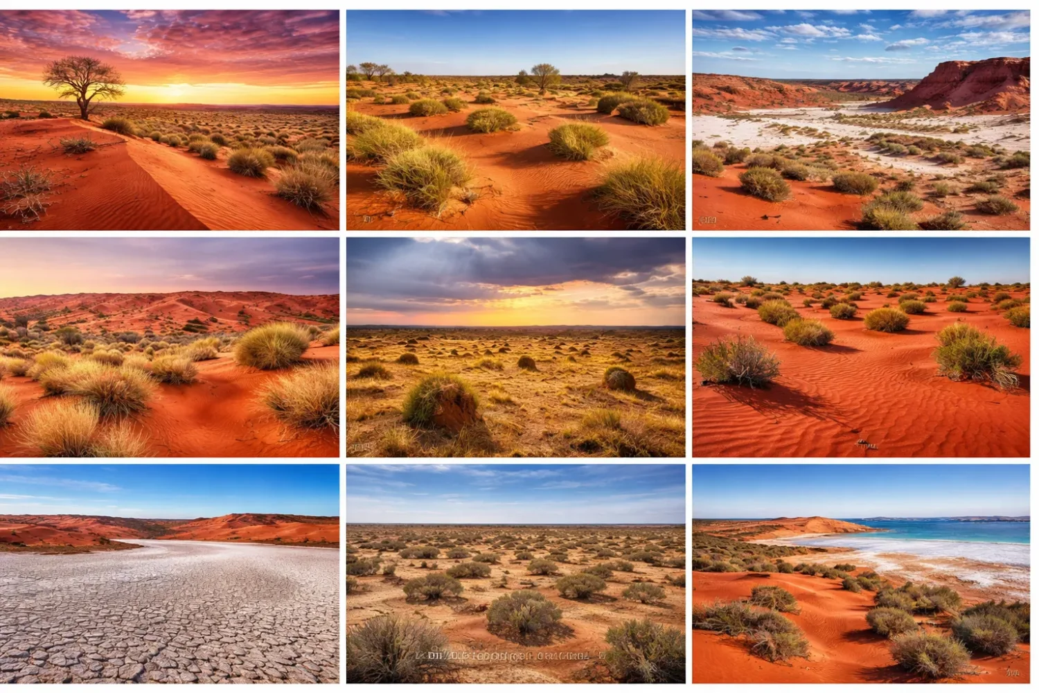
Australia’s desert belt is often imagined as one endless field of red sand. It is not. The 10 Australian deserts cover about 1,371,000 square kilometres, or roughly 18% of mainland Australia, yet they do not form one single landscape type. Some are made of long dune corridors. Some are built from gibber plains packed with stones. Others sit beside floodouts, salt lakes, clay pans, or old river systems that only come alive after rain.
Pedirka Desert
Location & Continent The Pedirka Desert is a compact dune field in the far north of South Australia,...
Read More →Tirari Desert
Location & Continent Continent: Australia Country / State: Australia – South Australia, Far North region Biogeographic setting: Part...
Read More →Sturt Stony Desert
Location & Continent Continent: Australia Country: Australia States: South Australia, Queensland, New South Wales Approximate Coordinates: 28°30′S, 141°00′E...
Read More →Strzelecki Desert
Location & Continent Continent: Australia (Oceania) Country: Australia States: South Australia, Queensland, New South Wales Region: Northeastern Lake...
Read More →Little Sandy Desert
Location & Continent Continent: Australia Country / State: Australia – Western Australia Region: Interior of Western Australia, part...
Read More →Gibson Desert
Location & Continent Continent: Australia (Oceania) Country: Australia State / Territory: Western Australia Approximate Coordinates: 23°S, 125°E Neighbouring...
Read More →Simpson Desert
Location & Continent Continent: Australia Country: Australia (Northern Territory, South Australia, Queensland) Coordinates: 24°34′S, 137°25′E Simpson Desert –...
Read More →Tanami Desert
Location & Continent Continent: Australia (Australasia) Country & States: Australia — Northern Territory and Western Australia Approx. Coordinates:...
Read More →Great Sandy Desert
Location & Continent Continent: Oceania (Australia) Country / State: Australia — Western Australia (minor extensions toward the Northern...
Read More →Great Victoria Desert
Location & Continent Continent: Oceania Country: Australia (Western Australia & South Australia) Coordinates: 29°S, 129°E (approximate geographic center)...
Read More →10 inventions in Oceania (Australia)
That is why a page about Australian deserts should do more than list names and sizes. It should explain how these dry regions fit together, where each one sits, what kind of surface it has, how rain actually behaves there, and why spinifex grassland, mulga woodland, floodwater, and bare stone all belong in the same arid story. Look closely and the pattern changes. Fast.
Another point matters too: the named deserts and the broader conservation bioregions do not always match neatly in size. In Australian desert writing, that detail gets skipped all the time. Here, it won’t. Where broader bioregion climate data helps explain a desert, it is treated as regional context, not as a sloppy substitute for the named desert itself. Small distinction. Very useful one.
This page focuses on the 10 mainland deserts recognized in Australian geographic listings: Great Victoria, Great Sandy, Tanami, Simpson, Gibson, Little Sandy, Strzelecki, Sturt Stony, Tirari, and Pedirka. Together they sketch the dry spine of the continent, from Western Australia to the Lake Eyre Basin.
What This Page Covers
- Where each desert lies and which states or territories it reaches
- Area data for all 10 deserts
- Climate and rainfall patterns where regional figures are available
- Landforms such as dunes, gibber, playas, floodouts, and sand plains
- Plants, animals, and land use across the arid interior
- The main differences between Australia’s sandy deserts and stony deserts
What Counts as a Desert in Australia?
In a broad physical sense, a desert is an area with very low precipitation. In Australia, the simple version is easy enough: dry country, low rain, high evaporation, sparse cover. Yet the line is not as neat on the ground as it looks on paper. Australian deserts can receive under 250 to 500 millimetres of precipitation a year depending on the classification used, but rainfall is so uneven from season to season that one wet spell can briefly hide the long dry pattern.
That is why named deserts in Australia are not defined only by bare sand or by one annual rainfall number. Surface form, vegetation structure, drainage, and regional climate all matter. A desert here may be a sea of parallel dunes. Or a hard, stony plain. Or a mosaic in which dunes, salt lakes, clay pans, and flood-carved channels sit side by side. Dryness is the shared rule. The look of the land is not.
That also explains why people are sometimes surprised to learn that Australia’s deserts are not empty of plants. Large parts of the interior support spinifex hummock grasslands, mulga shrublands, chenopod country, coolibah-lined watercourses, and short-lived herb growth after rain. The image of pure lifeless sand does not fit most of the continent’s arid zone. It never really did.
Why the Number Is 10
When people search for how many deserts are in Australia, they usually want the conventional mainland list of 10. That list is based on named geographic desert regions rather than every dry subregion or every conservation unit. It is a practical list. It is also the list most readers expect when they look for a full overview.
Still, it helps to know that desert names, IBRA bioregions, and geomorphic dunefields do not always line up perfectly. The Great Sandy Desert, for example, has a named desert area and a broader bioregion used in ecological reporting. Same with the Great Victoria, Gibson, and others. If you compare maps from geology, ecology, and tourism sources, the borders can shift a bit. Not because the science is confused, but because each map is answering a slightly different question.
Why Australian Deserts Often Look Green After Rain
Arid does not mean dead, and it does not mean static. Ephemeral rain can flip a desert surface from dusty and quiet to grassy and flowered in a short span of time. Floodwater from distant catchments can spread into swamps, lignum flats, or dune-edge creeks, especially in the Lake Eyre Basin. Then it dries again. That stop-start rhythm is one of the central traits of the Australian interior.
So when a reader asks what Australia’s deserts are “really like,” the honest answer is: variable. Fiercely so. One year may be dry enough for dust to dominate the view. A run of wet years can build fuel loads, fill swales, trigger bird breeding, and spark bursts of annual vegetation. Same place. Different face.
Where the 10 Australian Deserts Are
Most of Australia’s named deserts sit in the interior and western half of the continent. Western Australia holds the largest cluster, with the Great Victoria, Great Sandy, Gibson, and Little Sandy deserts all lying partly or wholly there. Farther east, the Simpson, Strzelecki, Tirari, Sturt Stony, and Pedirka deserts tie into the wider Lake Eyre Basin and the dry South Australian outback. The Tanami links the Northern Territory and Western Australia across a broad band of central dry country.
Geography matters here because the deserts are not isolated islands. They touch, grade, and overlap in character. The Simpson and Strzelecki are separated in part by the stony country of Sturt Stony Desert. Tirari sits beside Lake Eyre margins and river distributaries. Great Sandy and Little Sandy have clear identities, but both belong to the wider Western Australian drylands shaped by dunes, spinifex, and low woodlands.
| Desert | States / Territories | Area | Share of Mainland Australia | Surface Character |
|---|---|---|---|---|
| Great Victoria Desert | Western Australia, South Australia | 348,750 km² | 4.5% | Dunefields, playa lakes, lunettes, spinifex country |
| Great Sandy Desert | Western Australia | 267,250 km² | 3.5% | Red sand plains, dune systems, rocky outcrops |
| Tanami Desert | Western Australia, Northern Territory | 184,500 km² | 2.4% | Sand plains, low ridges, stony rises, hummock grassland |
| Simpson Desert | Northern Territory, Queensland, South Australia | 176,500 km² | 2.3% | Long parallel dunes, sand plains, floodouts, saltpans |
| Gibson Desert | Western Australia | 156,000 km² | 2.0% | Sand plains, dunefields, lateritic gibber plains |
| Little Sandy Desert | Western Australia | 111,500 km² | 1.5% | Dunefields, low ranges, acacia over spinifex |
| Strzelecki Desert | South Australia, Queensland, New South Wales | 80,250 km² | 1.0% | Orange-red dunefields, creek fans, swales, lake margins |
| Sturt Stony Desert | South Australia, Queensland, New South Wales | 29,750 km² | 0.3% | Gibber plains, tablelands, stony pavements |
| Tirari Desert | South Australia | 15,250 km² | 0.2% | North-south dunes, salt-lake margins, river-linked flats |
| Pedirka Desert | South Australia | 1,250 km² | Less Than 0.1% | Compact dune field, mulga country, low eroded dunes |
Why Australian Deserts Do Not All Look the Same
The first big difference is sand versus stone. Deserts such as the Simpson, Great Sandy, Great Victoria, Little Sandy, and Strzelecki are read mostly through dunes and sandy plains. Sturt Stony Desert is different. It is known for gibber, a desert pavement of weathered stones that armours the ground and creates a flat, open, almost metallic-looking surface under harsh light.
The second difference is water behavior. In some deserts, rain mostly vanishes into sand and sparse drainage. In others, water arrives from somewhere else. The Strzelecki and Tirari deserts are tied to the distributaries of Cooper Creek. Parts of the Simpson sit near floodouts and natural springs linked to the Great Artesian Basin. That is why some of the driest-looking country in Australia can still hold remarkable biological refuges when conditions align.
The third difference is north-south climate contrast. Northern deserts such as the Tanami and Great Sandy feel some monsoonal influence, with rain tending to be more summer-dominant. Southern deserts like the Great Victoria or Sturt Stony sit in a drier, less forgiving rain regime, though all of them share high variability. A desert may be hot and sandy in both places, yes, but not in the same way.
Then there is vegetation. Spinifex is the visual language of much of arid Australia, but it is not alone. Mulga, chenopods, gidgee, coolibah, marble gum, acacia shrub steppe, and floodplain shrubs all play their part. Across the desert belt, the land changes less like a switch and more like a gradient. Seen from above, it seems simple. On the ground, layered.
The 10 Australian Deserts
Great Victoria Desert
Great Victoria Desert is the largest named desert in Australia, with an area of 348,750 km². It stretches across Western Australia and South Australia, forming a vast southern arid belt that blends dune country, salt-lake basins, and broad dry plains. Readers often picture it as pure sand, but that misses the real shape of the place. This desert is a patchwork of dunefields, playa lakes, lunettes, spinifex plains, and scattered shrublands.
In regional ecological reporting, the broader Great Victoria bioregion records a median rainfall of about 162 mm. That number helps explain the desert’s rhythm: rain is low, highly variable, and never something the land can count on. When wet years do come, grasses and annual herbs respond quickly, and fire can follow after fuel builds up. In dry years, the country pulls tight again. Harsh, yes, but not uniform.
The broader bioregion is dominated by spinifex grassland mixed with marble gum, mulga, and other woody plants. That vegetation tells you a lot about the Great Victoria. This is not a bare erg in the North African sense. It is an Australian dryland where cover is often low but still ecologically active, and where the dunes are usually held in place by plants rather than drifting freely as mobile sand seas.
Another detail worth holding onto: only about 8% of the wider bioregion is grazed. Most of it remains remote from permanent or semi-permanent stock water. That limited pastoral reach helps preserve the desert’s broad feeling of distance. It also helps explain why remoteness is one of the Great Victoria’s defining traits. Huge spaces, sparse access, low settlement density. Few places in mainland Australia feel more withdrawn from the coastal pattern of life.
The Great Victoria also matters because it sits between better-known landscapes. To its north are other sandy systems. To its south, the land grades toward the Nullarbor and southern drylands. It works as a bridge in the continental arid belt, and in geological terms its dunefields show how Australian deserts do not begin and end in neat textbook blocks. Across that dry interior they merge, thin, reappear, and change character by region. Quietly they do it.
Great Sandy Desert
Great Sandy Desert covers 267,250 km² and ranks as the second largest of the 10 Australian deserts. It lies mainly in north-central Western Australia, with a broader desert setting that edges toward the Northern Territory. The surface is built from red sand plains, dunefields, and remnant rocky outcrops, which gives it a slightly rougher and more varied profile than many short summaries suggest.
The wider Great Sandy bioregion records a median rainfall near 223 mm, with an arid tropical climate in the north grading toward a more temperate-subtropical pattern in the south. That north-south shift matters. It means the Great Sandy is not just large in area; it also spans a real climate transition inside Australia’s drylands. In practical terms, rain stays unreliable, but its seasonality and feel can change from one sector to another.
Vegetation in the broader region is led by spinifex grasslands, low woodlands, and shrubs. That combination shapes the look of the Great Sandy: low, repeated forms rather than tall relief; hard horizons; vegetation that seems sparse at first and then starts to sort itself into distinct patterns across dunes, interdunes, and firmer ground. The land has a wide-screen feel to it. Horizontal country, mostly.
Only about 7% of the wider bioregion is grazed, which tells you how remote and lightly used much of it remains. Ecological reporting for the same region also notes a striking threatened mammal figure, with 24 threatened mammal species recorded in the broader bioregion, including several already lost from it. That statistic says something uncomfortable but plain: dry country may look open and tough, yet its fauna can be fragile under pressure from altered fire, invasive predators, and habitat disturbance.
The Great Sandy is often compared with the Little Sandy to its south and the Tanami farther east. That comparison is useful, but the Great Sandy stands apart because of scale and climatic reach. It is large enough to show how an Australian desert can change internally without losing its identity. Red dune country dominates, yes, yet not all red dune country is the same. Here the northern influence is part of the story.
Tanami Desert
Tanami Desert covers 184,500 km² and stretches across the Northern Territory and Western Australia. If the Great Victoria is southern and the Great Sandy is strongly western, the Tanami feels more central in the continental picture. It is a broad inland desert of sand plains, low ridges, alluvial flats, and stony rises, not simply a pure dune sea.
Regional reporting for the wider Tanami bioregion shows a median rainfall of about 298 mm, which is high by Australian desert standards. That does not make the Tanami wet. Not even close. It does mean the desert carries a semi-arid, monsoonal edge, with rainfall tending to fall in summer and variability staying extreme. Wet years can be very wet by local standards. Dry years can turn the whole place taut and brittle again.
The broader Tanami landscape is dominated by spinifex hummock grassland with a sparse shrub layer. Pastoralism, gold mining, and tourism all appear in regional land use, and roughly a quarter of the wider bioregion is grazed. This is one of the clearer examples of an Australian desert that is both remote and worked, a place where industrial activity and very old dryland ecology occupy the same map.
Fire is one of the Tanami’s recurring ecological forces. During sequences of wetter years, vegetation growth can build enough fuel for broad burns, and regional data shows very large areas burnt in some seasons. That is a useful reminder that arid country is not fire-free country. Quite the opposite. In spinifex landscapes, wet years can set up the next fire phase, and that cycle helps shape plant structure, patchiness, and habitat condition over time.
What makes the Tanami especially interesting is that it sits between common desert stereotypes. It is drier than the savannas to the north, but it still carries monsoonal fingerprints. It is sandy, yet not as iconic in public imagination as the Simpson. It is remote, but not untouched by roads, mines, or pastoral use. Across the Australian arid map, the Tanami acts like a hinge. Between north and centre it lies, broad and understated.
Simpson Desert
Simpson Desert is the most famous dune desert in Australia, and with good reason. Its named area is 176,500 km², spread across the Northern Territory, South Australia, and Queensland. In the public mind, this is the classic red desert: long ridges, giant skies, and a kind of clean, repeated geometry that looks almost impossible until you see it on a map or from the air.
Geologically and visually, the Simpson is known for its parallel sand dunes. It is widely regarded as one of the world’s clearest examples of a parallel dunal desert, and the dune field includes some of the longest parallel sand ridges on Earth, with certain ridges running for up to 200 kilometres. Heights vary across the system, with lower western dunes and taller eastern ones. That repeated ridge-and-swale pattern is the Simpson’s signature form.
The broader Simpson–Strzelecki dunefields region has a median rainfall of about 125 mm and includes the driest part of Australia. Rain usually comes as unreliable summer storms. Some years deliver just enough moisture to green the swales and wake ephemeral herbs. Others barely do that. Yet even here, water is part of the story. Parts of the Simpson sit above the Great Artesian Basin, and spring systems around the desert margins show how groundwater can create life pockets in brutally dry country.
The wider region also records a very high Dust Storm Index, plus broad grazing pressure along some margins, with about 49% of the wider Simpson–Strzelecki region grazed. At the same time, more than 15% of that wider region is protected within reserves. Those figures matter because they show the Simpson is not only scenic desert; it is also working rangeland, conservation land, and an active ecological system shaped by weather, livestock history, invasive species, and recovery after rain.
One common mistake is to describe the Simpson as only wind-made. Wind matters, of course, but not alone. Floodouts and buried drainage lines help explain the desert’s deeper structure, especially near its northern and north-western sectors. So the Simpson is not just a sand museum. It is a dry landform system where aeolian and fluvial processes meet. That sounds technical. On the ground it means this: wind built the ridges, but water still writes across the map.
Gibson Desert
Gibson Desert has a named desert area of 156,000 km² in Western Australia. It sits between the Great Sandy to the north and the Great Victoria to the south, which already hints at its role in the western desert chain. The landscape combines sand plains, dunefields, and lateritic gibber plains, so it often reads like a transition zone between different dry-country textures rather than one simplified landform type.
In the wider Gibson bioregion, the median rainfall is around 163 mm. That places it in the same harsh rainfall class as several southern and central deserts, with low totals and large year-to-year swings. Vegetation is mainly mulga and mixed shrubs over spinifex. So while the Gibson is plainly arid, it is also structured by plant cover in ways people often underestimate. Bare ground exists, but so does organized vegetation across immense distances.
The Gibson has a very low human population in its broader bioregion and large areas of Aboriginal land, conservation land, and unallocated crown land. That low settlement density is one reason it still feels less familiar than the Simpson to many readers, even though it is one of the largest deserts on the continent. Less publicity, more space. The desert keeps its own company.
Fire patterns in the broader region show another core Australian desert theme: after wetter years, fuel can rise enough to drive broader burns, especially through spinifex country. In dryland ecology, rain and fire are often chained together. Not immediately, not neatly, but strongly. The Gibson shows that well, because it is dry enough to seem still, yet active enough to shift when a run of good seasons arrives.
For readers comparing the western deserts, the Gibson is useful because it breaks the idea that each named desert is sharply self-contained. The Gibson shares traits with both the Great Sandy and the Great Victoria, but it does not dissolve into either one. It has its own balance of stony ground, low shrubs, spinifex cover, and open relief. Across Western Australia’s arid interior, that balance is part of what gives each desert its own identity.
Little Sandy Desert
Little Sandy Desert covers 111,500 km² and lies in Western Australia, south of the Great Sandy Desert. The name makes it sound like a smaller copy of its northern neighbour. That is only partly true. Yes, it shares a dune-rich, sandy structure. But it has its own ecological and spatial character, with dunefields, low ranges, acacia shrub steppe, and spinifex cover shaping the land.
The wider Little Sandy bioregion records a median rainfall near 178 mm. That keeps it firmly in Australia’s arid zone, though with a somewhat stronger summer rainfall pattern than the southernmost deserts. The land is mostly remote from stock water, and only about 2% of the wider bioregion is grazed. That low grazing footprint is one of the clearest technical clues to how isolated much of the Little Sandy remains.
Vegetation is led by acacia over spinifex, which fits the desert’s look: sandy ridges, low woody cover, and the hummocked texture that defines so much of arid Australia. In the broader reporting region, there were no known weed records at the time of assessment, which says something important about its remoteness and relatively light modification. Not every desert keeps that kind of ecological distance.
The Little Sandy also shows how wet years can ripple through a desert that otherwise appears stable. In one reporting period, a notable share of the wider bioregion burned after above-average rainfall helped build fuel. That sequence is classic Australian arid ecology: plants respond to rain, biomass rises, fire spreads, then recovery and patchiness follow. Drylands are not static backdrops. They react, and at times they react fast.
Compared with the Great Sandy, the Little Sandy feels more compact in public perception, but not in any trivial sense. Over 111,000 square kilometres is still enormous country. The difference is one of rank and context, not smallness in everyday terms. Put another way, the Little Sandy would be a massive desert almost anywhere else. In Australia, it happens to live beside even larger ones.
Strzelecki Desert
Strzelecki Desert covers 80,250 km² across South Australia, Queensland, and New South Wales. It sits in the north-eastern part of the Lake Eyre Basin and often gets described too briefly as just another dune desert. It deserves better than that. The Strzelecki is an orange-red dunefield, yes, but it is also a place where dunes, distributary channels, waterholes, swamps, and lake-margin systems work together in a way that is rare even by Australian desert standards.
In the broader Simpson–Strzelecki regional context, median rainfall is around 125 mm, with rain usually arriving in erratic summer events. Yet the Strzelecki’s story cannot be told by rain alone. Cooper Creek and its distributaries matter enormously here. The desert includes parts of the Cooper Creek fan, where flowing water, alluvial sediments, dunes, and interdune depressions have interacted over very long periods. Wind shaped the ridges. Water kept editing the page.
Geomorphically, the Strzelecki stretches for roughly 530 kilometres north to south and about 90 kilometres east to west in its broader dunefield form. It is bounded in places by elevated gibber country and by playas such as Lakes Blanche and Callabonna. That setting helps explain why the Strzelecki often feels different from the Simpson even when both are classed as sandy deserts. The Strzelecki is more entangled with distributaries, fans, and lake-edge processes.
This is one of the reasons the Strzelecki can support surprising biological richness in the driest country. Permanent and semi-permanent waterholes, distributary wetlands, and flood-linked systems create habitat contrasts that a simple “sand desert” label misses. The desert is dry, no doubt. But dry country with water structure is not the same as dry country without it.
As a reader, it helps to picture the Strzelecki not as a lesser-known copy of the Simpson, but as a neighboring desert with its own logic. The dune colour, the fluvial links, the southern lake margins, the contact with Sturt Stony Desert, and the wider Cooper system all make it distinct. Across eastern arid Australia, few places show the meeting of sand and inland water so clearly. It is desert, but layered desert.
Sturt Stony Desert
Sturt Stony Desert covers 29,750 km² across South Australia, Queensland, and New South Wales. In public imagination it is overshadowed by the bigger dune deserts, yet it may be the clearest lesson in how misleading the word desert can be. This is not a dune sea. It is a land of gibber plains, tablelands, and hard stony surfaces that can look almost paved from a distance.
The wider Stony Plains bioregion has a median rainfall of about 118 mm, making it one of the driest regional contexts in the country. The climate is very arid, with extreme temperatures, and vegetation includes chenopod shrublands, gidgee, and mulga woodlands in appropriate sites. That mix surprises people who expect a stony desert to be nearly vegetation-free. It is open country, yes, but not blank country.
The gibber itself deserves a plain explanation. These are closely packed stones left behind as finer material is stripped or redistributed over long periods. The result is a tough desert pavement that resists movement more than loose sand does. Under low-angle light, the surface can look silver-grey, bronze, or blackish depending on weathering and moisture. Beautiful in a severe way.
Land use in the wider stony region includes pastoralism and opal mining, with centres such as Coober Pedy, Oodnadatta, and Marla tied to the broader landscape. That does not make Sturt Stony less remote. It simply means this desert has long sat inside outback transport and production networks rather than outside them. In eastern and central Australia, many deserts are lived with rather than merely looked at.
The Sturt Stony Desert also acts as a separator and a connector. It helps divide the Simpson and Strzelecki dunefields in geomorphic terms, yet it belongs to the same wider arid story. If the sandy deserts show motion through repeated ridges, the stony desert shows endurance through surface armour. Same dry world. Different grammar.
Tirari Desert
Tirari Desert is one of the smaller named Australian deserts, with an area of 15,250 km² in South Australia. Small, though, is relative. This is still a very large desert in ordinary geographic terms. Tirari lies mainly east of Lake Eyre North and is built around north-south sand dunes, salt-lake margins, and flats shaped in part by distributary flow.
One reason Tirari matters is its position. It sits beside the Simpson and the Strzelecki and meets them in practical landscape terms around the wider Mungerannie and Birdsville Track country. That makes it a desert of transitions. Dunes are present, strongly so, but they do not operate alone. Warburton and Cooper-linked flood systems influence parts of the surrounding terrain, creating a desert where water history remains visible even when the surface looks dry and still.
Vegetation patterns in the broader Tirari country often alternate between dune crests, dune flanks, and lower interdune ground. Sandhill wattle, desert grasses, and shrubs can sort themselves by microtopography and moisture access, while flood-linked channels and flats support different plant assemblages again. That spatial variety is easy to miss if Tirari is reduced to a one-line entry in a list of 10 deserts.
Tirari also belongs to a part of Australia where inland rivers can outrun local rainfall. Water arriving from far upstream can spread across floodouts and low country even when nearby desert sectors stay brutally dry for long stretches. That mismatch between local rain and incoming water is one of the most interesting features of the eastern arid zone. It changes soils, plant cover, bird use, and the whole feel of a desert margin.
Compared with the louder names on this list, Tirari is understated. Yet that understatement is part of its value. It helps show that Australia’s desert system is not just a ranking of size. Some smaller deserts reveal more about the continent’s dry mechanics than a simple area figure ever could. Tirari is one of those places. Slightly overlooked, and worth more than a quick glance.
Pedirka Desert
Pedirka Desert is the smallest of Australia’s 10 named mainland deserts, covering about 1,250 km² in the far north of South Australia. Because it sits at the bottom of the size ranking, it is often treated as a footnote. That is a mistake. Pedirka is a compact desert, not an unimportant one. Its smaller scale makes it useful for understanding how even a relatively tight dune field can hold a clear desert identity.
Pedirka is generally described as a small dune field with deep red sands, low eroded parallel dunes, and dense mulga woodland in places. That already separates it from the image many readers carry for deserts. The smallest named Australian desert is not a bare, open pan. It is a sandy-mulga system with a more intimate structure than the giant dune fields farther east.
For regional context, Pedirka sits within the broader Finke bioregion, where median rainfall is around 152 mm and evaporation stays very high. In that broader setting, reporting on the Pedirka subregion shows that only about 15.5% of the sub-IBRA area lies within three kilometres of permanent or semi-permanent stock water. That is a technical number, but it tells a practical story: even in a smaller desert, water access remains sparse and strongly shapes land use and ecological pressure.
The Pedirka subregion was also reported as showing minimal persistent grazing gradients after major rainfall events, pointing to strong recovery in that reporting context. That kind of detail is helpful because it moves the discussion away from size alone. A small desert can still be ecologically instructive. Sometimes more so, because the surface relationships are easier to grasp at once.
Pedirka’s value in a full Australian desert page is almost symbolic. It closes the list, but it also sharpens the point that Australian desert identity is not only about vastness. Scale matters, yes. Yet so do surface form, vegetation, remoteness, and arid function. Pedirka may be the smallest named mainland desert, though it is still real desert country in every meaningful sense. Even a little rainfal there has to work hard.
Climate, Water, and Surface Patterns
Seen together, the 10 Australian deserts form a dry belt with clear internal contrasts. Median regional rainfall figures from broader desert bioregions range from about 118 mm in the Stony Plains context to roughly 298 mm in the Tanami context. That spread is large enough to shape vegetation and fire patterns, yet all of these places remain arid to semi-arid by Australian standards. None escapes water stress. They simply experience it in different ways.
Summer rainfall tends to matter more in the north and centre. The Tanami, Great Sandy, and Little Sandy all show stronger summer-dominant or monsoonal influence than the southern deserts. Farther south, the climate usually feels harsher and less forgiving, with lower totals and extremely high evaporation. The difference is not just academic. It affects shrub structure, fuel build-up, and the timing of biological response after rain.
Water enters the eastern deserts in a different way as well. In the Simpson, Strzelecki, and Tirari zone, distant catchments can feed flood systems that spread into the arid interior. This is why inland waterholes, floodouts, and wetland refuges can occur inside or beside some of the driest terrain on the continent. The paradox is only apparent. Once you understand the basin-scale drainage, it makes sense.
Surface pattern follows these water contrasts. Dunes dominate the better-known sandy deserts, but not all dunes are the same. The Simpson is famous for long, repeated parallel ridges. The Strzelecki mixes longitudinal dunes with creek-fan influence. Great Sandy and Great Victoria contain massive dune and sand-plain systems, yet with different climatic settings and associated vegetation. The stony deserts, by contrast, express dryness through pavements, gibber, hard ground, and broad open visibility.
Main Sandy Desert Pattern
Great Victoria, Great Sandy, Tanami, Simpson, Gibson, Little Sandy, Strzelecki, and Tirari all include broad sandy components, though the share of dunes, plains, swales, and alluvial features differs from one desert to the next.
Main Stony Desert Pattern
Sturt Stony Desert is the clearest gibber desert on the list, while Gibson and other regions also include stony or lateritic surfaces in parts of their wider landscapes.
Most River-Linked Desert Group
Simpson, Strzelecki, and Tirari are the most closely tied to floodouts, distributaries, springs, inland basins, and long-distance water movement from beyond the immediate desert margin.
Most Monsoon-Influenced Desert Group
Tanami and parts of the Great Sandy sit closest to the northern summer-rain pulse, which changes fuel, vegetation response, and landscape timing.
There is also a practical lesson here for readers comparing these regions: size alone does not predict appearance. The Great Victoria is the largest named desert, but it does not represent all Australian desert surfaces. The Pedirka is the smallest, yet it still shows classic arid dune-field structure. The Sturt Stony is much smaller than the Simpson, but visually the two could hardly be more different. Rank tells you scale. It does not tell you character.
Plants and Animals Across the Arid Belt
The backbone of many Australian deserts is spinifex, the hummock grass that shapes vast areas of dune country and sandy plains. In some places it is joined by acacia shrub steppe; in others by mulga woodlands, chenopods, gidgee, or sparse eucalypt components. This is one of the clearest differences between Australian deserts and the stereotype of a nearly plantless wasteland. Most of these landscapes are vegetated drylands, not naked ergs.
Plant distribution often tracks microtopography. Dune crests, dune flanks, swales, clay pans, saline flats, and floodplain edges all carry different soil and moisture conditions. In the sandy deserts, spinifex on crests and shrubs on flanks or interdunes are common visual patterns. In the stony regions, chenopod shrublands and tougher woody species fit the harder, shallower, rockier ground. One desert can look repetitive from a distance and very finely sorted when walked slowly.
Animal life also works on this patchiness. Broadly speaking, the deserts support reptiles, birds, invertebrates, and mammals adapted to heat, unpredictability, and sparse cover. Yet the record is mixed. Some broader bioregions show high numbers of threatened species and also losses. In the wider Great Sandy reporting region, threatened mammal counts are notably high. In the wider Simpson–Strzelecki region, threatened mammal listings include species already extinct from that landscape context. Dry country can be resilient. It can also be vulnerable.
Water-linked habitats punch above their size. Springs, swamps, waterholes, distributaries, and floodplain vegetation patches act as refugia in a broader dry matrix. This matters especially in the Lake Eyre Basin side of the desert belt, where the combination of dunes, inland rivers, and wetland pockets produces far more ecological contrast than a simple desert label suggests. Without those refuges, much of the eastern arid biodiversity story would read very differently.
Invasive animals remain part of the modern desert picture too. Regional reporting across several deserts notes the presence of feral cats, foxes, camels, rabbits, and other introduced animals. Fire can interact with these pressures by opening cover or changing post-rain habitat patterns. Again, the desert story is not one process but many. Plants, water, grazing, fuel, predators, and recovery all overlap.
Common Vegetation Themes Across the 10 Deserts
- Spinifex hummock grasslands dominate much of the sandy desert belt
- Mulga and acacia systems appear in several deserts, especially on firmer or less mobile substrates
- Chenopod shrublands are more typical of stony or saline country
- Coolibah and riverine woodlands occur where flood-linked water supports them
- Ephemeral herbs and grasses can briefly transform dune swales and flats after rain
Common Surface Features Readers Should Know
- Dunefield — broad area of repeated sand ridges and swales
- Gibber plain — stony desert pavement made of closely packed pebbles and stones
- Playa — dry lake bed, often salty, sometimes briefly flooded
- Floodout — place where a channel spreads and loses confinement across low ground
- Lunette — crescent-shaped dune or ridge often associated with lake margins
Desert Comparison Table
| Desert | Best Known For | Regional Rainfall Context | Vegetation Pattern | What Makes It Stand Out |
|---|---|---|---|---|
| Great Victoria | Australia’s largest named desert | Broader bioregion median about 162 mm | Spinifex, marble gum, mulga | Dunefields plus playa lakes and remote Aboriginal country |
| Great Sandy | Huge red sand plains in Western Australia | Broader bioregion median about 223 mm | Spinifex, low woodland, shrubs | North-south climatic grading inside one major desert |
| Tanami | Central desert with monsoonal edge | Broader bioregion median about 298 mm | Spinifex hummocks, sparse shrubs | Summer-dominant rain and large fire response after wet years |
| Simpson | Parallel red dunes | Broader regional median about 125 mm | Spinifex, acacia shrubs, riverine strips | Among the world’s clearest parallel dune deserts |
| Gibson | Sand and lateritic gibber mix | Broader bioregion median about 163 mm | Mulga, shrubs, spinifex | Transition feel between the big western deserts |
| Little Sandy | Remote dune country south of Great Sandy | Broader bioregion median about 178 mm | Acacia over spinifex | Very low grazing footprint in broader regional data |
| Strzelecki | Dunes linked to Cooper Creek systems | Broader regional median about 125 mm | Spinifex, shrubs, flood-linked vegetation | Rare meeting of dunes, fans, swamps, and inland channels |
| Sturt Stony | Classic gibber desert | Broader bioregion median about 118 mm | Chenopods, gidgee, mulga | Stone pavement rather than dominant sand ridges |
| Tirari | Dune desert beside Lake Eyre margins | Very low and erratic | Dune shrubs, grasses, flood-linked plants | Smaller desert shaped by both dunes and inland water |
| Pedirka | Australia’s smallest named desert | Finke regional context about 152 mm | Mulga, low dune vegetation | Compact dune field with clear arid character |
How These 10 Deserts Fit Together
Look at the full set of 10 and a clear structure appears. Western Australia holds the biggest sandy systems: Great Victoria, Great Sandy, Gibson, and Little Sandy. The central north is anchored by Tanami. The east and south-east of the arid interior are tied together by the Simpson, Strzelecki, Tirari, Pedirka, and the stony separator of Sturt Stony.
That pattern matters because it shows there is no single “Australian desert look.” What exists instead is a continental arid mosaic. Some deserts are famous because of scale. Some because of dune form. Some because they sit where inland rivers and dryland geomorphology collide. Some because they correct the cliché that a desert must be all sand. Read together, the 10 deserts form one of the clearest lessons in Australian physical geography.
They also show how dryland systems are built through overlap. Wind shapes dunes. Water shapes floodouts, distributaries, clay pans, and waterholes. Vegetation stabilizes or opens ground. Fire resets patch structure after wet phases. Land use alters pressure near water and along accessible margins. None of these processes works alone for long.
For anyone comparing deserts around the world, that last point is maybe the most useful one. The Australian desert belt is not defined by emptiness but by pattern: repeated dunes, stony pavements, episodic floods, low but persistent plant cover, and a climate that swings harder than outsiders often expect. Large deserts, small deserts, sandy deserts, stony deserts — all are part of the same arid continent, though each speaks with its own accent.