A desert map looks simple at first glance. Sand here, heat there, maybe a few camels and dunes. Real desert geography is far more layered. Desert regions stretch from the ice plains of Antarctica to the fog-fed coast of the Namib, from the rocky basins of the Great Basin to the cold gravel expanses of the Gobi. Some deserts burn under subtropical sun. Others stay cold most of the year. Some are famous because they are vast. Others matter because they show how dry landscapes form on a smaller, sharper scale.
That is why a pillar page on deserts by region works best when it does more than list names. It needs to explain why deserts appear where they do, how they differ by climate mechanism, surface, altitude, rainfall pattern, and continental setting, and why a desert region is often bigger than a single named desert. It also needs room for the polar deserts, because no world view of arid lands is complete without them. Cold, yes. A desert, still.
One idea helps from the start: a desert is defined mainly by lack of moisture, not by heat alone. Many sources use 250 millimetres of mean annual precipitation as a practical upper line for true deserts, while dryland science also uses the aridity index, which compares rainfall with potential evapotranspiration. In plain English, deserts lose water faster than they gain it. That simple balance shapes landforms, plants, animal life, soils, and even the way desert boundaries are drawn.
What Makes a Desert Region a Desert Region?
A desert region is not just a named patch on a school map. It is a wider arid system with its own climate logic, land surface, drainage pattern, and biological rhythm. In many parts of the world, the regional label matters more than the single desert name. Think of the North American desert belt: the Mojave, Sonoran, Chihuahuan, and Great Basin deserts are separate units, yet they also form a linked dry region shaped by mountain barriers, basin topography, and sharp rainfall gradients.
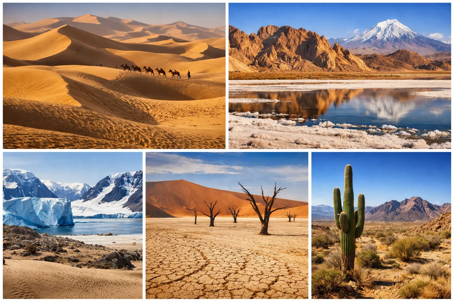
Many readers remeber deserts as dune seas first, because that image dominates films and posters. Yet only a small share of the world’s deserts is covered by active dune fields. Large desert areas are actually rocky plateaus, gravel plains, salt flats, dry basins, badlands, or ice-covered polar surfaces. The term erg refers to sand seas. Reg means gravelly desert. Hamada describes bare rocky plateaus. Add wadi, playa, sabkha, alluvial fan, and bajada, and the picture starts to look much more real.
Desert regions also blur into semi-arid and dry subhumid edges. Those edges matter. They hold many of the transition landscapes people casually call “desert”: scrub plains, steppe margins, thorn bush country, and dry badlands. In strict climate terms, not all of them are true deserts. In regional geography, though, they belong in the same conversation because they are part of the same dryland system.
Useful rule: a named desert is often a core unit, while a desert region includes the surrounding dry basins, semi-arid fringes, rain-shadow valleys, salt pans, and mountain fronts that make the system work as one landscape.
Dryland and Desert Are Not the Same Word
Drylands cover a much wider share of Earth than deserts alone. In dryland science, land is commonly grouped by the aridity index, with drylands extending from hyper-arid to dry subhumid conditions. That is why a continent can hold huge dryland belts without being mostly “desert” in the strict sense. This matters when you compare Africa with Europe, or Australia with South America. If you mix up drylands and deserts, the map gets messy fast.
It also matters for search intent. People looking up “deserts by region” usually want both the classic deserts and the larger regional pattern: where they are, why they are there, how they differ, and which named deserts belong to each zone. A list alone does not answer that. A region-based structure does.
Why Desert Belts Form Where They Do
Deserts do not appear at random. Their global pattern follows a small number of repeating controls. Once those controls are clear, the map of world deserts becomes much easier to read.
Subtropical High-Pressure Belts
Many of the world’s large hot deserts sit near 15° to 30° latitude north and south, where descending air in the Hadley circulation suppresses cloud formation and rainfall. This is why the Sahara, much of the Arabian Desert, parts of the Australian interior, and dry belts in southern Africa line up with the subtropics. The air sinks, warms, and dries. Clouds struggle. Rain stays sparse.
Cold Ocean Currents and Coastal Aridity
Some deserts sit beside the sea and still remain very dry. That sounds odd until cold currents enter the picture. The Benguela Current helps keep the Namib arid. The Humboldt Current supports the extreme dryness of the Atacama. These currents cool the air above them, reduce uplift, and limit rainfall even where fog may be common. The result is a coastal desert: moisture nearby, usable rain scarce.
Rain Shadows
Mountains create desert space by stripping moisture from air masses before they reach the inland side. The classic example is the Great Basin, where the Sierra Nevada helps block Pacific moisture. The same logic appears in the Patagonian Desert, lying east of the Andes, and in parts of the Gobi and Taklamakan, boxed in by high terrain. This control often creates deserts that are not just dry, but also thermally extreme, with hot days, cold nights, and sharp seasonal swings.
Continental Interiors
The farther a region sits from reliable ocean moisture, the harder it is for regular rainfall to reach it. Interior Asia shows this beautifully. So does the central Australian interior. These deserts are often broad, open, and structurally tied to basins, plateaus, and enclosed drainage. Water arrives rarely, then disappears fast into evaporation, infiltration, or terminal salt basins.
Polar Dryness
Cold air cannot hold much moisture. That simple fact creates the world’s largest desert bodies in the Antarctic and Arctic realms. Polar deserts look nothing like the Sahara, yet they share the same basic hydrological reality: very low precipitation. Antarctica, with an area of roughly 14.2 million square kilometres, is the world’s largest desert. The Arctic polar desert is slightly smaller, around 13.7 million square kilometres. Those numbers alone reset the usual picture of desert geography.
How Desert Regions Differ in Surface, Climate, and Scale
World desert regions do not vary by heat alone. They also differ by surface texture, water source, seasonality, and temperature range. Put another way, two places can both be deserts and still feel like different planets.
- Sand-Dominant Regions: ergs, dune seas, and long sand ridges, common in parts of the Sahara, Rubʿ al Khali, Simpson Desert, and Namib.
- Rock and Gravel Regions: reg and hamada surfaces, broad in the Sahara, Arabian Desert, and much of the Gobi.
- Salt and Basin Regions: playas, salars, chotts, sebkhas, and dry lake beds, seen in the Great Basin, Atacama margins, Sahara depressions, and central Asian basins.
- Cold Continental Deserts: strong temperature contrast, sparse vegetation, and winter snow, common in the Gobi and the Great Basin.
- Coastal Fog Deserts: moisture in fog, very little rain, a pattern seen best in the Namib and Atacama.
- Polar Deserts: very low precipitation, frozen ground, sparse biological cover, and huge ice-dominated surfaces.
There is another useful distinction: core desert versus desert region. The core desert is the driest part, often hyper-arid or plainly arid. The region around it may include steppe, thorn scrub, dry woodland, interior plateaus, basin margins, or ephemeral river systems that only wake up after rare rain. Those surrounding belts are not filler. They are part of the geography that makes the desert possible.
| Region | Main Dryness Pattern | Typical Surface | Representative Desert Units | Regional Character |
|---|---|---|---|---|
| Africa | Subtropical descent, coastal cold current, interior aridity | Ergs, regs, hamadas, gravel plains, fog desert, salt flats | Sahara, Namib, Kalahari, Libyan, Danakil | Largest hot-desert belt on Earth, with major contrasts between sand seas and bare rock |
| Asia | Interior distance, rain shadow, subtropical high pressure | Rock desert, gravel plain, sand basin, stony plateau | Arabian, Gobi, Taklamakan, Thar, Karakum | Most varied desert region by climate type, from subtropical heat to cold continental aridity |
| Australia/Oceania | Interior aridity, subtropical circulation, high evaporation | Sand ridges, gibber plains, salt lakes, shrub desert | Great Victoria, Great Sandy, Simpson, Gibson, Tanami | Broad dry interior with linked desert blocks rather than one single named desert |
| Europe | Rain shadow, Mediterranean dryness, steppe transition | Badlands, semi-arid basin, dry steppe, eroded claylands | Tabernas, Bardenas Reales, lower Volga-Caspian semi-desert zones | Smallest desert footprint in this page, but useful for understanding desert margins |
| North America | Rain shadow, basin-and-range topography, subtropical heat | Basin floors, salt flats, rock desert, cactus scrub, dune fields | Great Basin, Chihuahuan, Sonoran, Mojave, Colorado | Layered desert system with sharp elevation and rainfall contrasts |
| South America | Cold current, Andes rain shadow, subtropical margins | Coastal hyper-arid plain, salt basin, scrub steppe, gravel plateau | Atacama, Patagonian, Sechura, Monte | Extreme contrast between fog-fed coast and wind-swept southern steppe desert |
| Antarctic | Polar dryness, extreme cold, interior isolation | Ice sheet, bare rock, dry valleys, frozen desert surface | Antarctic Ice Sheet, McMurdo Dry Valleys | Largest desert region on Earth |
| Arctic | Polar dryness, cold air, short thaw season | Polar barrens, frost-shattered rock, sparse tundra-desert ground | High Arctic islands, Greenland margins, Svalbard, Arctic coastal barrens | Patchwork polar desert spread across northern landmasses and archipelagos |
Desert Regions of Africa
Africa anchors the global image of desert geography, and for good reason. It holds the Sahara, the largest hot desert on Earth, with an area of about 8.6 million square kilometres. Yet Africa’s desert story is not just about size. It is also about variety. On the same continent you find hyper-arid sand seas, rock plateaus, fog-fed coastal desert, and semi-arid sandy basins that blend into savanna and dry woodland.
The Sahara dominates the north, stretching from the Atlantic to the Red Sea. It is easy to imagine it as one endless dune field, but much of it is actually stony or rocky terrain. Ergs like the Grand Erg Oriental are only part of the picture. Wide regs, hamadas, volcanic uplands, interior basins, mountain massifs, dry wadis, and salt depressions all belong to the larger Saharan system. This matters because the Sahara is best understood as a desert region, not a single surface type.
Southwestern Africa gives a very different lesson with the Namib. This narrow desert strip runs along the Atlantic coast and exists because of the cool Benguela Current, stable dry air, and limited inland moisture delivery. It is one of the clearest examples of a coastal desert. Fog becomes more important than rainfall in some places, which is why Namib dune fields and gravel plains support such unusual forms of life. On a desert map, the Namib proves that rainfall total alone does not tell the full ecological story.
Farther inland, the Kalahari occupies a different place in the African dryland system. It is often called a desert, though large parts of it fall closer to semi-arid sandy dryland than to hyper-arid true desert. That is not a flaw in the label. It is a reminder that regional desert geography often includes transitional belts, where moisture is limited enough to shape sandy soils, shrub cover, drainage, and settlement patterns, even if some rainfall arrives seasonally.
The Libyan Desert, part of the eastern Sahara, brings the continent’s dryness into even sharper focus. This is where you find some of the most barren surfaces in North Africa, with huge rock expanses and very low rainfall. Nearby, the Danakil and Afar lowlands show another face of African aridity: below-sea-level depressions, evaporite-rich surfaces, and intense heat. Not all African deserts look alike. Not even close.
African desert regions also teach scale. North Africa holds one gigantic, almost wall-like desert belt, while southern Africa breaks dryness into different zones: the coastal Namib, the interior Kalahari, and drier steppe transitions around them. Those regions interact with the Sahel to the north of the savanna belt and with southern African plateaus farther south. Read the continent carefully and you see a set of linked dry systems, not a single block of emptiness.
Surface diversity is especially important in Africa:
- Ergs dominate parts of Algeria, Libya, Mauritania, and Egypt.
- Regs and hamadas cover huge Saharan tracts.
- Fog deserts define the Namib coast.
- Salt flats and evaporite basins appear in closed depressions.
- Wadis channel rare runoff after storms.
- Oases form where groundwater reaches the surface.
For a fuller continent-wide breakdown, the page on Deserts of Africa works as the natural companion to this pillar page. Africa’s dry geography is not just bigger than most others. It also gives many of the benchmark terms used in desert science: erg, reg, hamada, wadi, chott, and oasis all feel at home there.
One more thing deserves attention: Africa helps separate desert from desertification. The Sahara and Namib are natural desert systems. Desertification is a process of land degradation in drylands around or beyond these cores. Mix the two ideas together, and the map turns vague. Keep them apart, and African dryland geography becomes much clearer.
Desert Regions of Asia
Asia holds the broadest range of desert climates on this page. It contains the Arabian Desert, one of the world’s largest hot-desert systems at around 2.3 million square kilometres, and the Gobi, a cold desert and semidesert region of about 1.3 million square kilometres. Between and around those giants lie interior basins, plateau deserts, rain-shadow deserts, salt flats, and sandy basins that turn Asia into the most climatically varied desert region of all.
The Arabian Desert covers most of the Arabian Peninsula and includes famous units such as the Rubʿ al Khali, the largest continuous sand area in the world. In western imagination this is often the classic sand desert, and in part that image fits. But Arabia is also a land of rocky shields, lava fields, gravel plains, interior plateaus, wadis, and sabkhas. Its dryness comes mainly from subtropical high pressure, limited moisture penetration, and strong evaporation. Big sand. Bigger system.
North and east of Arabia, Asia changes character fast. The Syrian Desert, the Iranian interior, the deserts of Turkmenistan and Uzbekistan, and the Tarim Basin show how central and western Asia turn dryness into a pattern of enclosed basins, alluvial fans, salt lands, and continental temperature swings. These are not uniform desert seas. They are structural landscapes tied to tectonics, basins, mountain fronts, and ancient inland drainage.
The Gobi is the clearest break from the hot-desert stereotype. Much of it is not sandy. Large parts are bare rock, stony plain, or gravel desert. Winters can be bitterly cold. Snow may fall. Summer heat can still be intense. The Gobi sits in the continental interior and is shaped by a mix of distance from ocean moisture and topographic shielding. This is why it matters so much in a world-regional comparison: it proves that temperature does not define desert status; moisture balance does.
The Taklamakan adds another Asian pattern: the sand-basin desert. Ringed by mountains and held within the Tarim Basin, it is one of the great desert basins of the world. The encircling ranges trap the lowlands in an exceptionally dry rain-shadow setting. Desert rivers descending from the mountains lose force on alluvial fans or vanish into inland sinks. The result is a geography of sharp edge contrast: mountain snow outside, severe dryness inside.
Then there is the Thar Desert, which introduces a monsoonal edge to Asian aridity. Compared with the Rubʿ al Khali or the central Taklamakan, the Thar is more densely tied to seasonal rainfall variation, human land use, and dryland transition. It is still a desert region, but one with a very different rhythm. That makes Asia useful for another reason: it shows how desert regions can exist under more than one rainfall regime.
Asia also contains many dryland landforms that appear over and over in regional mapping:
- Sabkhas and salt crusts in closed or low-lying basins.
- Yardangs, shaped by wind erosion in very dry sedimentary zones.
- Alluvial fans at mountain fronts, especially around enclosed basins.
- Loess and dust transport corridors near major arid-source areas.
- Stone pavements in wind-deflated surfaces.
From a regional point of view, Asia is the best continent for seeing how deserts connect to plateaus, basins, and mountain arcs. The continent does not just contain deserts. It arranges them in corridors and bowls: Arabia to the southwest, Iranian and Syrian arid lands in transition, central Asian deserts inland, and East Asian cold desert systems beyond. The scale is huge. The logic is precise.
For the broader continental network, Deserts of Asia provides the next layer down from this pillar page. Asia rewards close reading because it carries almost every major desert type on Earth except the large polar systems.
Desert Regions of Australia and Oceania
Australia is the driest inhabited continent, and its desert geography feels different from Africa and Asia even before you name individual deserts. Much of the arid interior is linked as one large dry zone, often called the Great Australian Desert in a broad regional sense, even though it is built from separate named deserts such as the Great Victoria, Great Sandy, Gibson, Simpson, and Tanami. Official mapping of Australia’s ten deserts places them at nearly 20 percent of the national land area, with roughly 1.37 million square kilometres of named desert terrain.
This region shows why the phrase deserts by region is so helpful. Australia’s arid core behaves as a network of adjoining dry blocks, not as one cleanly isolated desert. Red sand ridges roll into gibber plains. Salt lakes sit in low interior basins. Shrublands, spinifex country, and stony surfaces blend into one another over long distances. On many maps, the named desert boundaries are real. On the ground, the transitions can feel gradual.
The Great Victoria Desert, Australia’s largest named desert, covers roughly 647,000 square kilometres. It is not a sea of bare sand from edge to edge. It includes sandhills, spinifex grass cover, stony ground, and dry lake features. That is true of much of inland Australia. Desert surfaces there often support more plant cover than outsiders expect, especially after episodic rain. Sparse, yes. Lifeless, no.
The Simpson Desert is famous for long parallel dunes, perhaps the clearest classic dune-desert image in Australia. The Gibson and Tanami show more mixed surfaces. The Great Sandy Desert pushes the sandy pattern farther northwest. Across them all runs a shared logic: limited and irregular rainfall, high evaporation, broad interior position, and continental-scale dryness shaped by atmospheric circulation and distance from dependable moisture.
Australian desert geography also highlights the role of gibber plains and ephemeral salt lakes. These are central to understanding the region. Many people know the dunes and miss the stone deserts. Yet the gibber surfaces, formed by weathered and wind-worked stone fragments, are among the most distinctive landforms of inland Australia. So are the playa-like lake basins that fill briefly and then retreat, leaving crusts, mudflats, or salt residue behind.
Another point worth keeping: Australian deserts do not always fit the old textbook idea of “less than 250 mm and that is that.” Some parts receive rainfall near that threshold or a bit above it in certain years, yet strong evapotranspiration keeps the landscapes arid in practice. In other words, water balance matters as much as raw rainfall totals. Australia makes that lesson easy to see.
The Australian interior is also one of the best places to understand desert connectivity:
- Desert ridges can run for long distances with repeated orientation.
- Salt-lake basins mark internal drainage and water loss.
- Spinifex plains give many desert surfaces a grassed texture rather than a bare one.
- Gibber country shows how rock and gravel can dominate where sand is expected.
In a global comparison, Australia sits between the Sahara-style hot desert and the basin-rich deserts of North America. It has huge dune systems, yes, but also wide stony tracts and dry inland depressions. It is less mountainous than many Asian and American desert regions, which changes the visual rhythm of the land. Long distances. Low relief in many sectors. Repeating dry patterns. That is Australia’s desert signature.
For the region-by-region breakdown of the continent’s named systems, Deserts of Australia is the natural follow-on page.
Desert Regions of Europe
Europe is the outlier in any global desert overview. It has the smallest true desert footprint of the regions on this page, and much of what people call “European desert” is better described as semi-arid, steppe, or badland terrain. That does not make Europe less interesting. In fact, Europe is useful because it shows how desert geography works at the margins, where climate thresholds, topography, and land surface shape small but very clear dry zones.
The most famous case is the Tabernas Desert in southeastern Spain. It covers about 280 square kilometres and receives under 250 millimetres of rain in a typical year, which places it within true desert conditions. Its location is not random. Tabernas sits within a rain-shadow setting, bounded by mountain systems that help block moist air. That is why the surface is so strongly developed into badlands, dry gullies, eroded clay slopes, and barren-looking channels rather than giant dune seas.
Spain also contains larger semi-arid landscapes often included in broader desert-region discussions, such as Bardenas Reales, the Monegros, and other dry southeastern basins. Strict climate purists may separate these from true desert. Regional geographers often keep them in the same family because the landforms, vegetation stress, erosional texture, and moisture deficit are part of one Mediterranean dryland conversation.
Outside Iberia, the European side of desert geography leans more toward semi-desert and dry steppe, especially around the lower Volga-Caspian zone and parts of southeastern Europe where continental dryness grows stronger. These are not Sahara-style spaces, and that is exactly the point. Europe helps explain that desert regions can exist as small climatic pockets, not only as continental giants.
Europe’s desert surfaces also make a strong teaching example. In Tabernas and similar dry badland landscapes, erosion often does more visual work than wind-built dune architecture. Rills, gullies, soft sediment slopes, and alluvial fans dominate the scene. This is a different desert aesthetic and a different geomorphic story. Dryness here teams up with episodic runoff and erodible materials, producing terrain that looks carved rather than piled.
Why keep Europe in a pillar page about deserts by region? Because it fills three gaps that many overview articles miss:
- It shows the desert threshold clearly. Europe makes it easy to see where semi-arid becomes desert.
- It highlights rain-shadow control. Small-scale mountain effects can produce striking local aridity.
- It stops “desert” from becoming a tropical-only word. Dryness is a climate balance, not a stereotype.
Europe also warns against a common mistake: treating every barren landscape as a desert. Some Mediterranean badlands are dry and erosive without being true deserts. Some steppe sectors are open and brown without crossing the desert threshold. Precision helps. So does regional context.
For the full continental picture, including Europe’s arid and semi-arid pockets, Deserts of Europe extends this section in a more place-by-place format.
Desert Regions of North America
North America may be the best region for understanding how several named deserts can join into one larger dryland system. The continental west and southwest contain the Great Basin, Mojave, Sonoran, and Chihuahuan deserts, along with related arid plateaus, valleys, and interior basins. Read separately, each desert has its own climate and ecology. Read together, they form a linked regional belt shaped by mountain barriers, latitude, elevation, and basin-and-range topography.
The Great Basin is the largest named desert region in the United States, covering about 492,000 square kilometres. It is a cold desert, and that single detail matters a lot. Winters can be cold. Snow is not unusual in higher areas. The dryness comes largely from the Sierra Nevada rain shadow, enclosed drainage, and strong evapotranspiration. Salt flats, sagebrush basins, dry valleys, alluvial fans, and fault-block ranges define the landscape far more than iconic dune imagery does.
The Chihuahuan Desert, spanning parts of the United States and Mexico, is often described as the largest desert in North America at around 520,000 square kilometres. Its geography differs from the Great Basin through warmer temperatures, distinct shrub and grass communities, and strong ties to interior Mexican basins and mountain ranges. It is broad, biologically rich for a desert, and structurally tied to the uplifted terrain around it.
The Sonoran Desert, with an area of about 310,800 square kilometres, is perhaps the most botanically iconic North American desert because of its cactus-rich landscapes, especially the saguaro zones. Yet even here, the region is more varied than the postcard suggests. The Sonoran includes plains, bajadas, mountain fronts, lava fields, and dune sectors, and it receives a mix of rainfall influences that differ from those of the Mojave or Great Basin.
The Mojave Desert sits between the Great Basin and Sonoran systems and often acts as a climatic and topographic hinge. It is famous for basins, creosote scrub, alluvial fans, Joshua tree zones on its margins, and sharply defined elevation-based transitions. Think of the Mojave as a dry middle ground where basin-and-range desert logic becomes especially visible.
North America also gives us one of the clearest examples of a desert region larger than its named parts. Broader definitions of the North American Desert can range from about 1.3 to 1.9 million square kilometres, depending on how far the connected arid and semi-arid belt is extended. This is a useful reminder that maps change with scale and method. A desert biome map, a rainfall map, and a named-desert map are not the same thing.
Landforms here repeat with textbook clarity:
- Basin floors and fault-block mountains
- Alluvial fans and bajadas
- Playas and salt flats in enclosed drainage basins
- Dune fields in localized sand-rich sectors
- Rain-shadow valleys downwind of major ranges
North America is also a strong example of desert layering by altitude. A short drive can move from hot basin floor to cooler upland scrub, then to woodland or montane zones. That vertical shift is not a side note. It is central to how the region works. Mountains do not just border the deserts. They create them, dissect them, and control their internal variety.
The full continental set of named systems is covered in Deserts of North America. As a regional case study, North America is hard to beat because it makes climate, topography, and landform connections so visible.
Desert Regions of South America
South America’s desert geography is built around contrast. In the west lies the Atacama, one of the driest non-polar deserts on Earth. In the south lies the Patagonian Desert, the largest desert region in the Americas at about 673,000 square kilometres. Between them stretch smaller arid systems and dryland transitions that show two very different ways a continent can produce deserts.
The Atacama Desert is a coastal and rain-shadow desert at once. It lies along the Pacific margin of northern Chile and southern Peru, where the cool Humboldt Current limits atmospheric instability and the Andes block moisture from the east. The result is a desert famous for extreme dryness, salt basins, bare volcanic landscapes, and some of the most stripped-down surfaces on the planet. The core Atacama region in Chile covers about 75,176 square kilometres, though the wider hyper-arid belt and related coastal-desert system are often discussed on a larger scale.
What makes the Atacama especially important in a regional guide is that it breaks the lazy equation of “desert = hot sand sea.” Much of it is not a dune world. It is a high, cool, rocky, salt-rich, and often astonishingly barren desert shaped by atmospheric stability, cold upwelling, and Andean topography. In geomorphic terms, it is a place of salars, volcanic cones, lava surfaces, gravel plains, and dry quebradas as much as it is a place of sand.
The Patagonian Desert tells a different story. It lies east of the Andes in southern Argentina and owes much of its dryness to the Andean rain shadow. Unlike the Atacama, Patagonia is not hyper-arid in the same way. It is a cold desert and semiarid scrub plateau, windy, open, and broad. Gravelly surfaces, shrub steppe, plateaus, and escarpments dominate. If the Atacama feels compressed and mineral, Patagonia feels spacious and wind-carved.
South America also includes the Sechura Desert in Peru and the Monte drylands of Argentina, which are often pulled into wider regional discussions because they connect coastal aridity, subtropical dryness, and steppe transition. Again, this is where the language of desert regions is more useful than a simple list of strict climatic deserts.
There is a neat continental symmetry here. The west coast gives a cold-current desert. The southern interior gives a rain-shadow desert. One hugs the ocean and one sits behind mountains. One is famous for extreme lack of rain. The other is famous for wind, steppe-desert texture, and long plateau surfaces. Both belong in the same continental desert story, yet they emerge from very different controls.
South America’s dryland landforms commonly include:
- Salars and salt flats in enclosed high or interior basins.
- Gravel plains and open stony surfaces in Patagonia.
- Volcanic and lava-based terrain near the Atacama-Andean setting.
- Fog-influenced coastal sectors on the Pacific margin.
- Dry valleys and alluvial fans where mountain runoff fades into arid plains.
For a place-by-place expansion, Deserts of South America builds on this continental overview. South America matters in any global comparison because it includes both one of the driest non-polar regions on Earth and the largest desert region in the Americas.
Desert Regions of Antarctica
Antarctica changes the whole scale of desert geography. Covering about 14.2 million square kilometres, it is the largest desert on Earth. That statement still surprises many readers because the usual mental image of desert remains hot, sandy, and sun-blasted. Antarctica is none of those things most of the time. It is cold beyond ordinary comparison, covered largely by ice, and defined by very low precipitation. Yet by moisture balance, it fits the desert category cleanly.
The interior of Antarctica receives so little snowfall that parts of it get less than 50 millimetres of precipitation in a year. Some sectors are, in effect, drier than famous hot deserts. The difference is that the moisture arrives and remains mostly as snow and ice, while evaporation and sublimation work under extreme cold and wind. The hydrological outcome is still desert-like: very little incoming moisture.
Antarctica also reminds us that desert surfaces do not need exposed sand or gravel to qualify as desert landscapes. Vast ice sheets can belong to a desert system. So can the famous McMurdo Dry Valleys, where exposed ground, salty lakes, freezing temperatures, and almost no snowfall create one of the most unusual desert environments on Earth. In popular writing, Antarctica is often treated as a technical exception. It is better seen as a full desert region with polar rules.
Those rules include:
- extreme atmospheric dryness
- low absolute humidity
- very limited precipitation
- strong katabatic winds
- long-term ice dominance
Another reason Antarctica belongs in a pillar page like this is comparison. Without it, readers end up with a distorted size ranking in which the Sahara seems to be the top desert because it is the largest hot desert. The real ranking is broader: Antarctica first, Arctic second, Sahara third. That does not reduce the Sahara’s importance. It just makes the global map more accurate.
Antarctic desert geography also helps explain why temperature and moisture should be treated separately. The continent is frigid because of latitude, elevation, albedo, and polar light conditions. It is a desert because moisture input is tiny. Two different controls. Same region.
For a dedicated polar breakdown, Antarctic Desert expands on the continent’s ice-based aridity, interior dryness, and dry-valley landscapes.
Desert Regions of the Arctic
The Arctic is not a continent in the same way Antarctica is, but it absolutely belongs in any serious world-desert overview. Its polar desert reaches across the northernmost parts of North America, Europe, and Asia, including sectors of Greenland, the Canadian Arctic Archipelago, Svalbard, Arctic Russia, and other High Arctic lands. In area, the Arctic polar desert totals roughly 13.7 million square kilometres, making it the second largest desert region on Earth.
What defines the Arctic desert is not emptiness alone. It is a combination of very low precipitation, thin soils, short thaw windows, and cold conditions that restrict biological growth. In some places the surface grades from sparse tundra into true polar barrens where plant cover becomes extremely limited. This is why the Arctic often sits on the border between tundra and polar desert in ecological mapping. The driest High Arctic sectors tip clearly toward desert.
Unlike Antarctica, the Arctic desert is not one single continuous landmass. It is a patchwork region, spread across islands, coasts, and northern continental margins. That makes it more complex to picture, but also more useful in a regional guide. It shows that a desert does not need a single iconic core. It can exist as a network of dry polar environments linked by climate type rather than by one uninterrupted land body.
Surface conditions in the Arctic desert often include frost-shattered rock, polygonal ground, thin active layers above permafrost, sparse moss and lichen cover, and local snow accumulation in sheltered zones. On first look, some of these areas may not resemble a desert to the public eye. Yet the defining hydrological pattern remains the same: little incoming moisture and a strong limit on available liquid water.
The Arctic also adds nuance to one of the oldest misunderstandings in geography: that deserts are mainly places of blazing sun and towering dunes. In the Arctic, the desert story is colder, lower, and rougher. Bare ground can sit beside ice. Snow may exist without abundant precipitation. Freeze-thaw action and wind can shape the surface as much as running water does in warmer regions.
Why keep the Arctic separate from North America and Europe in this pillar page? Because its desert identity is polar and circumregional, not simply national or continental. It crosses conventional borders and behaves as one climate realm. That is exactly how regional geography should be read.
For a deeper look at this northern polar system, Arctic Deserts takes the subject beyond the summary given here.
What World Desert Maps Often Miss
Not All Barren Land Is Desert
Badlands, dry steppes, volcanic fields, and eroded clay basins can look desert-like without always meeting desert thresholds. The reverse is also true: some true deserts support more shrubs, grasses, or seasonal bloom than people expect. Appearance helps, but it can mislead. Rainfall pattern, evaporation demand, and aridity are the better guides.
Not All Deserts Are Sand
Dunes cover only a minority of total desert area worldwide. If a page on deserts shows sand in every section, it teaches the wrong lesson. Rock, gravel, salt, clay, ice, and sparse scrub surfaces dominate immense parts of the global desert estate. This is one of the biggest content gaps in weak desert overviews, and it matters because landform type shapes ecology, drainage, and human use.
Polar Deserts Are Not Footnotes
Many list-style pages mention Antarctica and the Arctic as trivia, then move on. That leaves readers with a skewed scale model. Polar deserts are not a side note. They are the largest desert regions on the planet. Any page titled “Deserts by Region” should treat them as structural chapters, not as a curiosity at the end.
One Continent Can Hold More Than One Desert Logic
Africa contains both subtropical and coastal-fog desert systems. Asia combines hot subtropical deserts with cold continental ones. South America pairs a coastal hyper-arid desert with a rain-shadow steppe desert. North America layers basin-and-range deserts across different temperatures and elevations. The continent name is only the first step. Inside each region sits a more detailed climate story.
Desertification Is a Process, Not a Synonym
A natural desert is not the same as a landscape undergoing desertification. The first is a climatic region. The second is land degradation in drylands, often at the margins or in human-used systems. Mixing those terms weakens both science and geography. Keep the distinction clear and the page becomes much more useful to readers.
Largest Reference Deserts by Region
| Desert or Desert Region | Approximate Area | Region | Type | Why It Matters |
|---|---|---|---|---|
| Antarctic Desert | 14.2 million sq km | Antarctica | Polar desert | Largest desert on Earth |
| Arctic Desert | 13.7 million sq km | Arctic | Polar desert | Second largest desert region on Earth |
| Sahara | 8.6 million sq km | Africa | Hot desert | Largest hot desert |
| Arabian Desert | 2.3 million sq km | Asia | Hot desert | Largest desert in Asia |
| Gobi | 1.3 million sq km | Asia | Cold desert | Classic continental cold desert |
| Australian Named Deserts Combined | About 1.37 million sq km | Australia/Oceania | Interior arid system | Shows a continent-scale linked desert core |
| Patagonian Desert | 673,000 sq km | South America | Cold steppe desert | Largest desert region in the Americas |
| Great Victoria Desert | 647,000 sq km | Australia/Oceania | Hot desert | Largest named desert in Australia |
| Chihuahuan Desert | 520,000 sq km | North America | Hot desert | Largest named desert in North America |
| Great Basin | 492,000 sq km | North America | Cold desert | Classic rain-shadow basin desert |
| Tabernas Desert | 280 sq km | Europe | Hot desert / badland desert | Europe’s clearest true desert example |
How to Read Desert Regions on a Global Scale
If you zoom out, a few broad patterns emerge. Africa and Asia carry the heaviest concentration of classic low-latitude desert belts. Australia holds the most continuous inhabited continental interior aridity. North America gives the clearest stacked system of named deserts shaped by topography. South America holds some of the strongest contrast between coastal and rain-shadow desert types. Europe preserves the threshold cases. The Antarctic and Arctic show that the largest deserts on Earth are polar.
That global structure also helps explain why desert regions matter so much in biogeography, geology, and climate reading. They are not just empty spaces between greener places. They are organized climate landscapes with repeatable rules. Pressure belts, mountains, cold currents, drainage closure, frost action, dune transport, salt concentration, fog input, and vegetation stress all leave signatures on the map. Learn those signatures, and a world desert map stops being a list of names and starts reading like a system.
Plain-language summary of the planet’s desert layout: the largest deserts are polar, the largest hot desert is African, the widest climate variety sits in Asia, the most continuous inhabited dry interior is Australian, and the clearest multi-desert topographic system is North American.
Seen this way, a pillar page on deserts by region does more than connect continent pages. It gives readers a usable mental model. Africa is not just “the Sahara continent.” Asia is not just Arabia plus Gobi. South America is not just Atacama. Europe is not “no deserts.” Antarctica is not “ice, therefore not desert.” The regional method fixes all of those shortcuts.