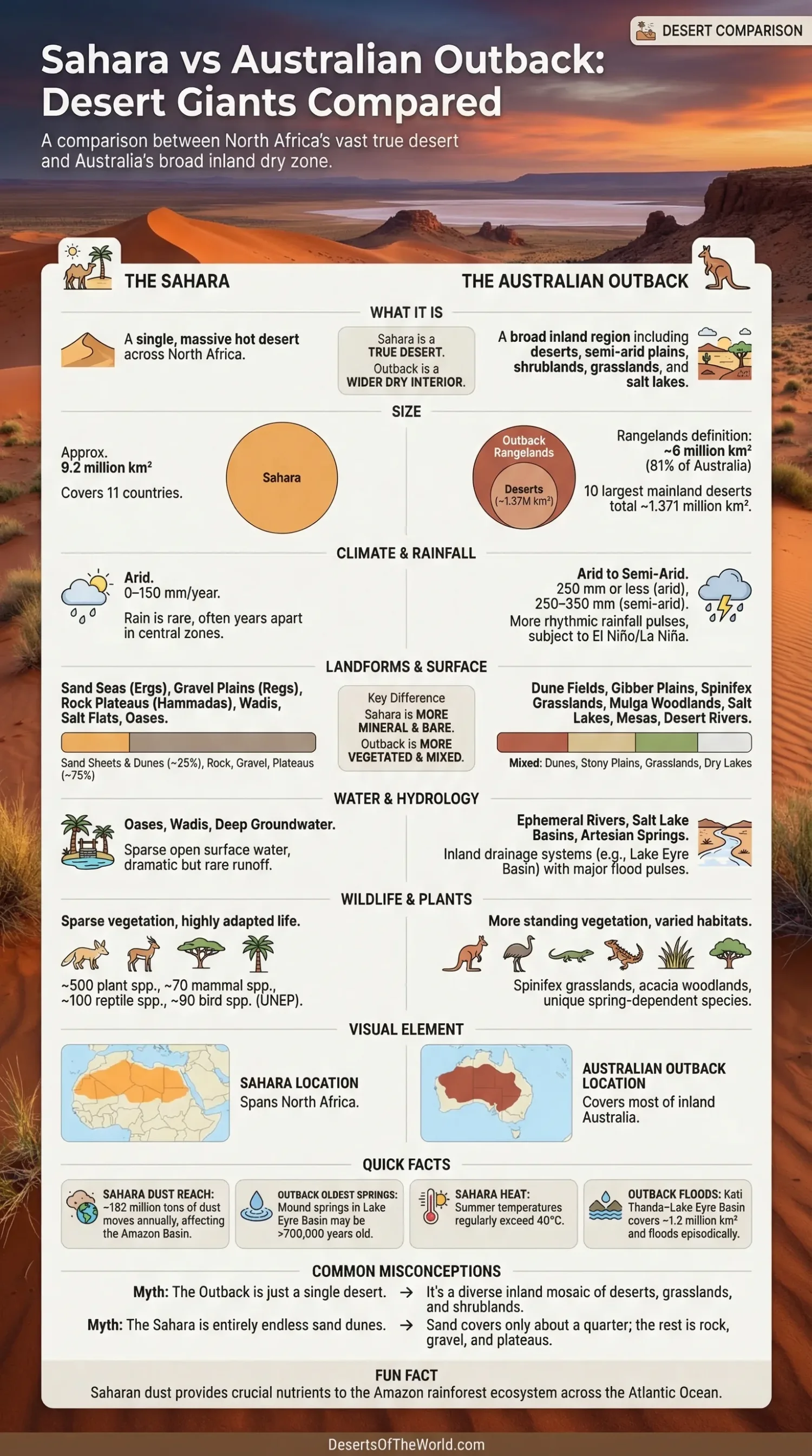
Put the Sahara beside the Australian Outback, and the first job is to fix the comparison. The Sahara is a single, named hot desert. The Australian Outback is a much broader inland region that includes deserts, semi-arid plains, shrublands, grasslands, woodlands, salt lakes, and river country. So this is not a neat desert-vs-desert match. It is really a comparison between one vast African desert and Australia’s wider dry interior.
That difference matters. A reader searching this topic usually wants a simple winner on size, dryness, heat, and landscape. Geography is less tidy than that. The Sahara wins easily as a true desert. The Outback becomes more competitive only when the word means the full inland dry zone, not just Australia’s named deserts.
| Point | Sahara | Australian Outback |
|---|---|---|
| What It Is | A single hot desert across North Africa | A broad inland Australian region that includes deserts and many semi-arid landscapes |
| Scale | About 9.2 million km², across 11 countries | About 81% of Australia if the rangelands definition is used; the 10 largest mainland deserts total 1.371 million km² |
| Rainfall | Usually 0–150 mm a year, with many areas far drier | Arid areas are 250 mm or less; semi-arid areas are often 250–350 mm |
| Surface Look | Sand seas, gravel plains, rock plateaus, wadis, mountains, salt flats, oases | Dune fields, gibber plains, spinifex country, mulga, salt lakes, mesas, desert rivers |
| Water Pattern | Mostly rare runoff, wadis, groundwater, and oasis systems | Ephemeral rivers, inland drainage, artesian springs, flood pulses into salt-lake basins |
| Vegetation | Sparse over huge areas | Often more vegetated, with grasslands, shrubs, and open woodlands across wide tracts |
First, Fix The Map
Many comparisons go wrong in the opening line. The Sahara and the Outback do not sit at the same level on the map.
- The Sahara is a single desert system with a widely understood boundary and a global identity of its own.
- The Outback is a cultural and geographic term for remote inland Australia. It includes deserts, but it is not only desert.
- Australia’s desert estate is the better one-to-one match if the goal is a strict desert comparison.
That is why the phrase “Sahara vs Australian Outback” needs a small correction before the real comparison starts. If the question is Which desert is bigger? the Sahara wins by a huge margin. If the question is Which inland dry world covers more of daily Australian imagination and map space? the Outback enters the frame, because it stretches far beyond the limits of named deserts.
Size: One Desert Vs One Inland World
On raw area, the Sahara is the heavyweight. It covers about 9.2 million square kilometres. That makes it the largest hot desert on Earth and one of the largest desert regions of any kind. The name alone carries scale.
Australia’s 10 largest mainland deserts add up to about 1.371 million square kilometres, or around 18% of the mainland. So if the clean comparison is Sahara vs Australian deserts, the African side is not just larger. It is vastly larger — about 6.7 times the size of those ten mainland deserts combined.
The picture changes when people use Outback in the broad Australian sense. Government rangeland mapping treats about 81% of Australia as rangelands, the area many Australians loosely associate with the Outback. In that wider reading, the Outback reaches about four-fifths of the continent, or a little over 6 million km². That still leaves the Sahara ahead, but the gap narrows a lot.
So the size verdict is simple:
- As a true desert: the Sahara is much larger.
- As a broad remote inland zone: the Outback is huge, but the Sahara still covers more ground.
Landforms: Sand Is Only Part Of the View
Popular images flatten both places into endless dunes. That is wrong twice. The Sahara is famous for ergs, yet sand sheets and dunes cover only about a quarter of its surface. The rest includes regs and serirs (gravel plains), hammadas (rock plateaus), mountain massifs, dry valleys, and salt basins. In other words, the Sahara is not one unbroken sea of sand. It is a patchwork of rock, gravel, sand, and dry basin landforms.
The Outback works the same way. It is not one red dune field from edge to edge. Its dry heart includes parallel dunes in the Simpson Desert, stony gibber plains, spinifex grasslands, acacia and mulga country, playa lakes, salt pans, isolated mesas, and wide alluvial plains. In South Australia’s Simpson country alone, dune systems sit beside playa lakes, spinifex cover, and open woodland. It looks dry, yes. It does not look empty in one single way.
The contrast is easy to miss becuase both names trigger the same picture in many readers. Yet on the ground, the Sahara often feels barer and more mineral, while the Outback more often mixes bare ground with living cover. Even where the Outback is very dry, shrubs and hummock grasses can still shape the whole scene.
Two technical points sharpen that contrast:
- Sahara landforms often show strong aeolian sorting: dune seas, deflation surfaces, desert varnish, gravel armor, and broad rock plateaus.
- Outback landforms more often pair aeolian forms with ephemeral fluvial systems: dunefields next to floodplains, creeks, claypans, and inland drainage basins.
Climate: Heat, Rain, and Seasonal Rhythm
If the question is Which one is drier? the answer is the Sahara. In the Saharan region, average annual rainfall commonly falls in the 0–150 mm range, and many parts receive only a few tens of millimetres in a year. Some central zones are so dry that rain becomes an event, not a season. Surface water may vanish fast, and dry channels can stay empty for long stretches.
The Outback is dry too, but its climate has more rhythm. Australia’s arid zone is commonly defined as land receiving 250 mm or less of rain a year, while the semi-arid zone often falls in the 250–350 mm band. That is still a hard climate. Still, it allows more plant cover and more ecological response after rain than the Sahara usually can.
Another difference sits in the atmosphere above them. The Sahara is shaped by subtropical high pressure, dry descending air, intense sunshine, and very low cloud cover. Inland Australia also sits under dry high-pressure influence, but the Outback has stronger year-to-year swings from the subtropical ridge, El Niño–Southern Oscillation, the Indian Ocean Dipole, monsoonal spillover in the north, and cold fronts reaching inland from the south.
That is why the two places can feel so different after rain. In the Sahara, rare storms may send sudden runoff through wadis and low basins. In the Outback, one wet pulse can wake grasses, push wildflower flushes, fill claypans, and send water far through channel systems. Dry places, both of them. But not dry in the same tempo.
Heat is fierce in both regions. Daytime summer temperatures above 40°C are not unusual in either landscape. Yet the Sahara usually feels more relentlessly arid, while the Outback often feels more variable — hot, dusty, then briefly green after rain, then dry again.
Water: Oases, Wadis, Desert Rivers, and Salt Lakes
Water tells the clearest story of all. In the Sahara, water is often tied to oases, shallow depressions, mountain runoff, wadis, and deep groundwater systems. Oases matter because they break the dryness with palms, settlement, cultivation, and local biodiversity. Outside these pockets, open surface water is scarce over huge distances.
The Outback handles water in a different way. It contains desert rivers, internal drainage systems, and broad salt-lake basins that may look empty for long periods, then suddenly hold or move water after distant rain. The Kati Thanda–Lake Eyre Basin alone covers about 1.2 million km² of outback Australia. It shifts between long droughts and huge inland flood pulses. That hydrology gives the Outback a stop-start pulse that many classic desert comparisons leave out.
This is one of the most useful ways to compare the two giants:
- Sahara water geography: sparse, localised, oasis-based, with runoff that is brief and often dramatic.
- Outback water geography: episodic but far-reaching, with channels, basins, floodplains, salt lakes, and artesian groundwater shaping whole regions.
The springs of inland Australia make the contrast even sharper. Some mound springs around the Lake Eyre and Great Artesian Basin country are thought to be more than 700,000 years old. These spring systems support at least 98 species found only in springs, along with about 33 distinct regional species combinations. That is a very Australian kind of desert life: hidden, water-linked, local, and surprisingly layered.
Life On Dry Ground: Plants, Animals, and Adaptation
The Sahara supports life, but it does so with wide spacing and tough filters. Vegetation is sparse over great stretches, then thicker in wadis, mountain zones, depressions, and oasis margins. UNEP summaries for the Sahara list around 500 plant species, 70 mammal species, 100 reptile species, and 90 bird species. That may sound modest next to wetter biomes, yet it is notable for a desert this dry and this large.
Plants in the Sahara survive by cutting water loss, reaching deep moisture, or taking quick advantage of short wet windows. The living cast includes acacia, date palms, drought-tuned shrubs, scattered grasses, and annuals that wait for rain. Animal life is equally tuned for heat, shade, and movement: fennec foxes, dorcas gazelles, reptiles, desert birds, and many small nocturnal species built for a strict water budget.
The Outback usually reads as greener. That does not mean wet. It means the Australian dry interior often keeps more standing vegetation across more space. Spinifex grasslands, mulga shrublands, saltbush, acacia woodlands, and scattered riverine trees give much of the Outback a mixed texture of bare earth and plant cover. From satellite view, the color palette often moves from rust red to muted green to white salt. Rarely just one tone.
This matters because it changes how the land works. Vegetation slows erosion, traps sediment, feeds fire cycles, shelters reptiles and birds, and turns short rain pulses into bursts of growth. The Outback’s dry ecosystems can look quiet, then respond with speed after rain. The Sahara also responds after rain, of course, but the response is often more local and shorter-lived over its driest heart.
Wildlife tells the same story. The Outback is known for animals such as the red kangaroo, emu, perentie, and thorny devil, along with many birds and small reptiles tied to dune fields, shrublands, and floodplains. In simple terms, the Sahara is often more austere; the Outback is often more ecologically textured.
Dust, Soils, and Surface Color
Step back from local scenery and the Sahara starts to dominate at Earth-system scale. NASA estimates that about 182 million tons of Saharan dust move past the western edge of the desert in an average year. Roughly 27.7 million tons of that dust falls over the Amazon basin. That gives the Sahara a reach far beyond North Africa. Its dust affects ocean water, sky color, air quality, and nutrient movement across the Atlantic.
The Outback produces dust too, and central Australia can throw large plumes during dry, windy periods. Still, its dust role is not usually discussed in the same planet-wide way. The Sahara is the more famous global dust engine.
On the ground, the colors of the two landscapes come from different mixes of material and cover. The Sahara often leans toward gold, tan, pale brown, black rock, and white salt. The Outback leans toward iron-red soils, orange dunes, grey-green shrubs, white playas, and dark gibber stone. The famous Australian red comes from iron oxides in old weathered surfaces. The Sahara’s broad dune fields, quartz-rich sands, gravel plains, and rock plateaus create a more mineral palette.
That color difference shapes the public image of each place. The Sahara fits the classic poster image of a great desert. The Outback looks more mixed and more lived-in by plants, even where rainfall stays low.
Direct Answers Most Readers Want
- Which Is Bigger As a Desert? The Sahara, by a very wide margin.
- Which Is Drier Overall? The Sahara.
- Which Is More Vegetated? The Australian Outback.
- Which Has More Mixed Land Cover? The Australian Outback, because it includes deserts plus broad semi-arid country.
- Which Has the Bigger Global Dust Role? The Sahara.
- Which One Is Harder to Define With a Single Boundary? The Australian Outback.
- Which Comparison Is Fairest? Sahara vs Australia’s desert system for a pure desert match, and Sahara vs the Outback when the goal is a broader look at dry continental interiors.
So the clean reading is this: the Sahara is the larger and harsher desert giant, while the Australian Outback is the more varied dry interior. One is a single desert of planetary scale. The other is a giant inland mosaic where desert, grass, shrubs, dunes, salt, and sudden water all share the map.
Sources
- Geoscience Australia – Areas of Australian and Territory Deserts (sizes of the 10 largest Australian mainland deserts)
- Australian Government DCCEEW – Outback Australia: The Rangelands (how the Outback/rangelands are defined and how much of Australia they cover)
- Bureau of Meteorology – Subtropical Ridge (why central Australia is so dry)
- Bureau of Meteorology – Australian Rainfall During El Niño and La Niña Events (year-to-year rainfall swings across Australia)
- Bureau of Meteorology – Indian Ocean Dipole (how Indian Ocean patterns shift Australian rainfall)
- U.S. Geological Survey – Bioclimatic Regions Map: Saharan Region (Sahara landscapes and rainfall range)
- NASA Earth Observatory – A Deluge for the Sahara (rainfall rarity and flood response in the Sahara)
- NASA – Saharan Dust Feeds Amazon’s Plants (dust transport volumes from the Sahara)
- UNEP – Virtual Journey Through Desert Ecosystems (Sahara scale and biodiversity figures)
- Geoscience Australia – Kati Thanda–Lake Eyre Basin (size, hydrology, and inland flood–drought cycles in outback Australia)
- CSIRO – Arid Springs of Outback Australia (spring age and endemic species in inland Australia)
- National Parks and Wildlife Service South Australia – Munga-Thirri–Simpson Desert National Park (dune systems, playa lakes, spinifex grasslands, and acacia woodlands)
- Encyclopaedia Britannica – Sahara (surface forms such as ergs, regs, hammadas, and the share of dunes and sand sheets)