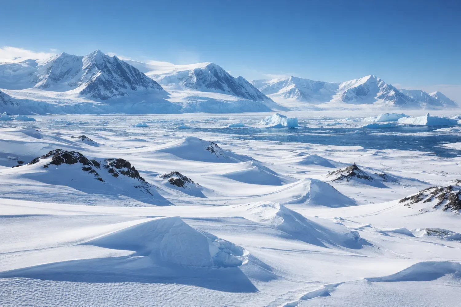
The Antarctic Desert overturns the usual image of a desert. There are no dune seas stretching to a hot horizon, no thorn scrub, no baked salt flats under a white sun. Instead, there is ice, wind, rock, blue glare, and extreme dryness. That last part matters most. A desert is defined by very low precipitation, and on that measure Antarctica is not just a desert but the largest desert on Earth.
Meyer Desert
Meyer Desert – Location & Continent Continent: Antarctica Region: Ross Dependency, Transantarctic Mountains (northern Dominion Range) Nearby features:...
Read More →McMurdo Dry Valleys
Location & Continent Continent: Antarctica Region: Victoria Land, along the coast of the Ross Sea and McMurdo Sound...
Read More →Antarctic Desert (Polar Desert)
Photos of the Antarctic Desert Location & Continent Continent: Antarctica – a vast polar desert wrapped around the...
Read More →3 inventions in Antarctic
It is also the coldest, windiest, highest, and driest continent. Those labels are not decorative. They explain why snow can lie in place for ages, why vast parts of the interior receive only tiny amounts of moisture each year, and why bare ground appears in select pockets where wind, topography, and ice movement work together in unusual ways. Strange at first glance, very logical once you slow down and look.
This desert includes the immense ice sheet that covers almost all of the continent, but it also includes the exposed rock, polar plateaus, blue-ice fields, nunataks, dry valleys, frozen lakes, brine pockets, and old sediment outcrops that preserve pieces of Antarctica’s warmer past. In a single polar desert you can move from a surface colder than most freezers to a pond so salty it resists freezing, and from lifeless-looking gravel to soils where microbes, algae, lichens, nematodes, and ancient climate evidence are all present.
13,661,000 km²
Less Than 50 mm in Much of the Interior
Katabatic Winds
Ice-Free Oases
McMurdo Dry Valleys
Meyer Desert
The Antarctic Desert in Measured Terms
| Feature | Measured Detail | Why It Matters |
|---|---|---|
| Area | About 13,661,000 km² including islands and ice shelves | That scale makes it the planet’s largest desert by area. |
| Average Elevation | About 2,500 m | High ground keeps air cold and dry, which suppresses moisture. |
| Ice Thickness | Up to 4 km thick in places | The desert is mostly ice-covered, not sand-covered. |
| Average Annual Precipitation | About 150 mm water equivalent for the continent as a whole | Desert status comes from low precipitation, not from heat. |
| Interior Precipitation | Less than 50 mm water equivalent across much of the plateau | This places much of inland Antarctica in a hyper-arid class. |
| Coastal Precipitation | Usually above 200 mm, locally over 1,000 mm near the Bellingshausen Sea | The continent is not uniform; coastal Antarctica is much wetter than the interior. |
| Lowest Recorded Temperature | −89.2°C at Vostok | This is the coldest ground-measured air temperature on Earth. |
| Ice-Free Land | Less than 1% of the continent | Most land ecosystems are squeezed into very small exposed areas. |
What Makes Antarctica a Desert
Start with the definition and much of the confusion disappears. A desert is a place that receives very little precipitation. Heat is optional. Sand is optional. Cacti are optional too. If the yearly moisture budget stays low enough, the place qualifies as a desert. Antarctica does, and by a wide margin.
Over much of the inland plateau, annual precipitation falls below 50 mm water equivalent. That is drier than many famous hot deserts. The continent-wide average is still only about 150 mm, even after wetter coastal belts are included. So the image many people carry around in their heads—snow everywhere, therefore not a desert—does not hold up. Snow cover and desert status are not opposites. In Antarctica they sit side by side.
The reason is simple and physical. Very cold air holds very little moisture. The air over the high Antarctic interior is frigid, dense, and dry. Much of the continent is far from open water for long periods, which limits available atmospheric moisture. Large areas sit under persistent high pressure. Cloud formation stays limited. Precipitation stays low. Snow that does fall tends to linger because temperatures are so low that melt and evaporation are restricted for long stretches of the year.
So yes, the surface is packed with ice. Still, the climate remains desert climate. That is the distinction that matters. Antarctica is icy because it is cold enough to preserve snowfall for immense spans of time, not because it is wet.
Why the Antarctic Desert Looks So Different From Hot Deserts
Hot deserts usually reveal their dryness through open soil, sparse vegetation, and exposed rock. Antarctica often hides its dryness beneath accumulated ice. That difference can make the continent feel like a category of its own, but it is still desert terrain shaped by aridity, wind, freeze-thaw stress, sublimation, and limited liquid water.
In the Sahara or the Namib, low rainfall leaves the ground exposed. In Antarctica, low snowfall combines with very low melt and very low biological activity. Ice builds up over long spans, yet bare ground still appears where local conditions favor exposure: on nunataks, in coastal oases, in windswept blue-ice zones, and most famously in the dry valleys. Desert processes are there all the time, even when the surface does not look like a classic desert postcard.
That is why the Antarctic Desert deserves to be treated as a full desert system, not as a trivia answer. It has its own precipitation gradients, exposed desert pockets, soil chemistry, wind-driven landforms, saline lakes, and old sediment archives. Under the ice, above the ice, and in the rare ice-free ground, the desert shows itself in different ways.
Why Ice Does Not Cancel Desert Conditions
A useful way to think about Antarctica is this: the continent stores water, but it does not receive much new water each year. That stored water sits in the ice sheet, glaciers, shelves, and snowpack. The annual input, though, is low over most of the interior. That mismatch is what makes Antarctica look wet while behaving dry.
The cold does another thing. It reduces biological turnover. Soil formation is slow. Organic matter stays scarce. Chemical weathering is limited compared with warm deserts. Moisture does not move through the ground in the same way it would in subtropical arid lands. Instead, many Antarctic desert surfaces are shaped by frost shattering, salt concentration, wind abrasion, and sublimation.
Where the Antarctic Desert Begins and Ends
In the broadest sense, the Antarctic Desert covers nearly the whole continent of Antarctica and its ice-dominated surface. It stretches across East Antarctica, West Antarctica, the Antarctic Peninsula, and the arching margins where glaciers feed ice shelves. But desert conditions are not expressed with equal force everywhere. The interior plateau and certain ice-free valleys are the driest. Coastal sections are less dry, and some parts of the Antarctic Peninsula receive much more snowfall than the polar plateau.
That unevenness is worth noting because “Antarctica” is often spoken of as if it were one flat climate block. It is not. The continent includes:
- High interior plateau deserts with extremely low precipitation and severe cold
- Coastal polar deserts where moisture is higher but still limited compared with non-polar coasts
- Ice-free desert pockets such as dry valleys and rocky oases
- Blue-ice areas where wind and sublimation remove surface snow
- Mountain desert margins where nunataks and exposed ridges interrupt the ice sheet
The clearest lesson is this: the Antarctic Desert is not one uniform white slab. It is a huge polar desert system with many local expressions. Some parts are buried under kilometers of ice. Some parts are bare and gravelly. Some contain summer meltwater streams. Some contain ancient sediment and fossils. Sparse, yes. Monotonous, no.
East Antarctica, West Antarctica, and the Peninsula
East Antarctica holds the largest continuous section of the ice sheet and much of the highest interior terrain. It is the part most people imagine when they think about the coldest, driest, most elevated Antarctic conditions. This is where moisture becomes vanishingly scarce and air temperatures plunge to the lowest measured values on the planet.
West Antarctica differs in topography and ice-sheet behavior, with lower-lying areas and major outlet glaciers. Parts of it still fit clearly within the desert picture, but the landscape is more geologically varied, and some zones connect more directly to changing ocean influence. The Antarctic Peninsula, jutting toward South America, is the mildest major region. It is still Antarctic and still dry by many standards, but it receives more snowfall and shows a more maritime climate.
This regional contrast matters whenever someone asks, “How can Antarctica be a desert if it snows there?” The answer is that coastal and peninsula snowfall does not erase the hyper-arid interior. A desert can have wetter edges. Antarctica does.
Climate and Weather Across the Antarctic Desert
The Antarctic Desert runs on a climate recipe unlike any low-latitude desert. High elevation. Very cold air. Long polar night. Intense seasonal light in summer. Low atmospheric moisture. Strong gravity-driven winds. Add those together and you get a place where even weather basics behave differently from the usual desert pattern.
Temperature
Antarctica’s average annual temperature ranges from roughly −10°C on the coast to about −60°C in the highest interior. Near the coast, summer temperatures can push above +10°C in a few places, while winter can drop below −40°C. Inland, summer may only rise to around −30°C, and winter can sink below −80°C. The official world record low, −89.2°C, was measured at Vostok.
These are not just dramatic numbers. They control nearly every desert process on the continent. They limit how much moisture the air can hold. They reduce melting. They slow biological activity. They keep salts concentrated in certain basins. They decide where streams can flow, when lake ice opens, and how quickly snow that falls can become buried, compacted, or stripped away.
Wind
Wind is one of the true sculptors of the Antarctic Desert. Katabatic winds form when extremely cold, dense air over the elevated ice sheet flows downhill under gravity. These winds can accelerate through valleys and over steep coastal slopes, sometimes staying strong for days. Gusts well above 200 km/h have been measured, and recorded wind speeds in Antarctica have reached up to 327 km/h.
In desert terms, katabatic winds do several jobs at once. They scour loose snow, expose blue ice, strip humidity from local air masses, shape drifts, drive sublimation, and help maintain ice-free surfaces in select places. In the dry valleys, this wind action is one of the reasons snow does not simply accumulate and bury the ground. It gets removed.
Precipitation
Most Antarctic precipitation falls as snow or ice crystals. Rain is mainly a coastal event, and even there it is limited by polar standards. Over the plateau, annual precipitation stays under 50 mm water equivalent. Near many coastal areas it exceeds 200 mm, and near the Bellingshausen Sea it can climb above 1,000 mm. That spread is large. The continent, in other words, has a real moisture gradient.
Yet even where snowfall is higher, desert logic still applies over broad areas because evaporation, sublimation, blowing snow, intense cold, and low biological productivity all keep the system closer to a polar desert than to a snowy temperate landscape. It is a cold desert with regional variety, not a weatherless block of ice.
Light and Seasonality
Antarctica’s seasons are driven as much by light as by temperature. Summer brings months of nearly continuous daylight to high latitudes. Winter brings the reverse. That seasonal rhythm matters because brief summer warmth unlocks the desert’s limited hydrology. Glacial margins start to melt. Stream channels react. Lake moats can open. Surface salts dissolve or migrate. Soil moisture pulses appear and then vanish again.
The system is seasonally active, but only for a short window. Then it shuts down. Fast. That pulse-like behavior is one reason Antarctic desert ecology feels so finely tuned. A few degrees, a few weeks, a few hours of meltwater—sometimes that is enough to change an entire valley floor.
Desert in Antarctica does not mean endless dryness every minute of the year. It means the annual moisture budget stays very low, liquid water is rare and short-lived in most places, and the landscape is shaped by aridity as much as by cold.
How the Surface of the Antarctic Desert Is Built
The surface of the Antarctic Desert is not one thing. It is a mix of continental ice sheet, glaciers, ice shelves, mountain ridges, nunataks, frozen lakes, and scattered ice-free desert ground. Understanding Antarctica means noticing how these surfaces connect rather than treating them as separate worlds.
Ice Sheet and Ice Shelves
Most of the continent is covered by the Antarctic ice sheet, which stores about 90% of Earth’s ice and about 90% of Earth’s fresh water. In some places the ice is up to 4 km thick. At the edge, glaciers feed floating ice shelves that extend over the ocean. These shelves are not deserts in the same visual way as exposed gravel or sand, but they belong to the same cold, low-precipitation system.
Think of the ice sheet as the main body of the desert and the exposed oases as windows through it. Those windows are small, but scientifically they are huge. They let researchers read rock history, soil history, old climates, and ecological patterns that would otherwise stay sealed below ice.
Nunataks, Blue-Ice Areas, and Rocky Oases
Nunataks are mountain peaks or ridges that protrude above the ice sheet. They matter because they expose bedrock, catch wind differently, and provide some of the few stable ice-free refuges for tiny terrestrial life. Blue-ice areas form where wind and sublimation remove surface snow faster than new snow can accumulate. These zones often look polished, dense, and luminous, almost metallic under clear polar light.
Rocky oases, often along the coast or in mountain margins, are among the rare places where the Antarctic Desert shows its bare face. Here you see patterned ground, frost-split rock, gravel veneers, salts, shallow soils, and sparse biological crusts. Small in area, but outsized in value.
Permafrost and Patterned Ground
Much Antarctic desert ground is affected by permafrost. Freeze-thaw action, ground ice, and thermal contraction create polygonal patterns, stone sorting, cracks, and other cold-desert textures. In hot deserts, water and thermal expansion often do more of the visible shaping. In Antarctica, frost and aridity team up. The result is a terrain that can look almost engineered—circles, stripes, polygons, and sorted stone fields laid out across valley floors and terrace surfaces.
These features are not decoration. They record how the ground exchanges heat, moisture, and salts. They also help scientists compare Antarctica with other dry worlds, especially Mars, where similar-looking patterned ground and arid sediments attract strong interest.
The McMurdo Dry Valleys: Antarctica’s Clearest Desert Landscape
If one place makes the Antarctic Desert immediately legible, it is the McMurdo Dry Valleys. Located in Victoria Land near McMurdo Sound, these valleys are the largest ice-free region in Antarctica, covering about 4,800 km². Here the usual mental picture of Antarctica breaks apart. The valley floors are mostly bare. Gravel dominates. Snow cover is sparse and unstable. Streams run only in summer. Lakes stay ice-covered for long spans. The air is so dry that even nearby ice behaves differently.
This region is often described as one of the driest and coldest desert environments on Earth, and the description fits. Powerful katabatic winds descend from the plateau and sweep through the valleys, stripping snow and humidity. The Transantarctic Mountains also create a snow-shadow effect, which further limits accumulation. Put those controls together and you get a polar desert landscape so stark that it has become one of the best natural analog sites for Mars studies.
The main valleys usually discussed are Taylor Valley, Wright Valley, and Victoria Valley. Each has its own mix of glaciers, lakes, soils, and microclimates, but the shared pattern is clear: little snowfall, strong wind, seasonal meltwater, frozen ground, and a surface ruled by aridity. Strange to say it about Antarctica, but this is desert country in a very direct visual sense.
Why the Dry Valleys Stay Dry
The dryness of the McMurdo Dry Valleys comes from a stack of local controls rather than from one single cause. The surrounding mountains block ice flow and help reduce snow delivery. Katabatic winds remove fresh snow before it can settle. Very low humidity keeps sublimation active. Summer warmth is limited and brief, so meltwater appears only seasonaly and usually in narrow stream channels fed by glacier edges and snowbanks.
There is also a feedback effect. Once a valley floor is exposed, darker rock and sediment absorb more solar energy than a snow-covered surface would, but the environment still remains so cold and dry that large-scale vegetation and deep active soils never develop. You get a landscape with open ground, yet not the plant cover that many non-polar deserts manage after rain.
Lakes, Streams, and the Onyx River
The Dry Valleys are not dry in the sense of having zero water. They are dry in the sense that liquid water is scarce, tightly limited, and strongly seasonal. During the austral summer, meltwater from glaciers and snow patches feeds short stream systems. These channels carry sediment and dissolved salts across valley floors and into lakes. Then the flow fades.
The best-known stream is the Onyx River in Wright Valley, often described as Antarctica’s longest river. It runs from Lake Brownworth to Lake Vanda during the melt season and offers a rare example of a functioning river system inside the polar desert. Its presence tells you something important about the Antarctic Desert: even here, where aridity is severe, brief hydrological windows can shape landforms, transport nutrients, and sustain microbial habitats.
The lakes are just as striking. Many remain capped by thick perennial ice, yet liquid water survives below. That upper ice acts like a lid. It reduces wind mixing, limits heat exchange, and creates chemically unusual environments beneath. Some lakes are stratified. Some are saline. Some preserve long records of climate and hydrology. They are desert lakes, but not the kind most people expect.
Lake Vida, Don Juan Pond, and Other Extremes
Lake Vida is one of the Dry Valleys’ most famous examples of hidden liquid water in extreme cold. Beneath a thick ice cover lies a cold, enclosed brine environment that has drawn wide scientific interest because it preserves unusual chemistry and microbial survival strategies. It is the sort of place that forces a re-think of what “too harsh for life” really means.
Then there is Don Juan Pond in Upper Wright Valley, an ankle-deep basin whose calcium-chloride-rich brine is so salty that it rarely freezes. For a desert article, it is one of Antarctica’s best reminders that dryness and salinity often travel together. In hot deserts salts may collect in playas. In the Antarctic Desert they collect in cryogenic basins, brines, pore waters, and thin films associated with freezing, sublimation, and atmospheric moisture exchange.
Nearby, Blood Falls at Taylor Glacier adds another layer to the picture. Iron-rich brine emerging from the glacier oxidizes on contact with air, producing the deep red color that made the feature famous. It looks dramatic, but the scientific lesson is quiet and clear: the Antarctic Desert contains hidden water systems, hidden salt systems, and hidden microbial habitats beneath surfaces that appear static from a distance.
Life in the Dry Valleys
At first glance the Dry Valleys seem empty. They are not. Their biological communities are stripped down, small in biomass, and highly local, but they are present in soils, streambeds, lake margins, ice-covered water bodies, and rock interiors. Microbial mats, cyanobacteria, algae, lichens, mosses in select moist spots, and tiny soil animals such as nematodes, tardigrades, and rotifers all play roles.
This simplicity is part of what makes the region so valuable. Food webs are shorter. Water controls are sharper. Climate signals can be easier to trace through the system. In a more complex ecosystem, one change can be muffled by many interacting layers. In the McMurdo Dry Valleys, a shift in melt timing or soil moisture may show up more plainly in stream flow, lake chemistry, or the balance of soil organisms.
Why the Dry Valleys Matter Beyond Antarctica
Scientists study the Dry Valleys not only to understand Antarctica but also to test ideas about cold-desert ecology, permafrost behavior, saline water persistence, and planetary analog landscapes. The region has long been used as an Earth analog for certain Martian environments because of its cold, dryness, exposed sediment, salts, and limited but meaningful interaction with liquid water.
That does not mean the Dry Valleys are “Mars on Earth.” They are not. Antarctica still has active glaciers, ice-covered lakes, atmosphere, and living microbial systems. Still, the comparison is useful because it pushes attention toward the same questions: Where can water persist in extreme cold? What signatures does life leave behind in arid mineral settings? How do salts change habitability? Those are desert questions as much as they are planetary ones.
The Meyer Desert: A Small Ice-Free Desert With a Big Climate Story
The Meyer Desert is far smaller and less widely known than the McMurdo Dry Valleys, yet it carries one of the most revealing stories in the Antarctic Desert. Situated near the northern end of the Dominion Range, close to the confluence of the Beardmore and Mill glaciers, this ice-free area covers roughly 50 square miles or about 130 km². In raw area it is modest. In paleoclimate value, it is anything but modest.
What makes the Meyer Desert special is not merely that it is exposed ground within the polar desert. It is that the Meyer Desert Formation at Oliver Bluffs preserves evidence of a far milder Antarctic past. Fossil plants, fossil insects, invertebrates, paleosols, and associated sedimentary deposits have all helped show that tundra-like conditions once existed deep within Antarctica, at latitudes around 85°S. That is one of the most striking climate signals anywhere on the continent.
In other words, the Meyer Desert lets the Antarctic Desert speak in two voices at once. One voice describes the present—cold, dry, wind-shaped, mostly barren. The other voice comes from buried deposits and says that parts of Antarctica once supported a tundra environment under conditions very different from today. Few sites do that so clearly.
Location and Setting
The Meyer Desert lies within the Transantarctic Mountains, a vast mountain chain that separates East Antarctica from West Antarctica. This alone gives it geological weight. The Transantarctic Mountains are one of the main structural backbones of the continent, exposing rock sequences and sedimentary archives that would otherwise remain hidden beneath the ice sheet. The Meyer Desert sits in this larger mountainous desert setting, where glaciers, cliffs, sediment benches, and ice-free ledges work together to preserve older environmental signals.
Unlike the McMurdo Dry Valleys, which are widely discussed as active cold-desert landscapes, the Meyer Desert often appears in scientific conversation mainly because of its fossil-bearing deposits. That focus makes sense, but it can hide the equally useful geographic point: this is also a true Antarctic desert landform—snow-free ground sustained in part by local topographic control, glacier dynamics, and persistent polar aridity.
The Meyer Desert Formation and What It Preserves
The Meyer Desert Formation forms part of the Sirius Group and includes glacigenic and fluvial deposits preserved at Oliver Bluffs. These sediments contain some of the youngest known terrestrial plant macrofossils and paleosols found in Antarctica. Their content matters because it is not just one stray fossil or one odd layer. Taken together, the deposits point toward a tundra environment that included vascular plants, mossy or peaty surfaces, insects, invertebrates, and soils formed under conditions warmer than those of the present continent.
Estimates drawn from these deposits suggest mean annual temperatures around −12°C, with short summers reaching up to about +5°C. In Antarctic terms, that is a different climate world. Cold, yes. But not the ultra-cold hyper-arid desert that defines inland Antarctica today. It implies seasonal thaw, wet-based glacial influence, liquid water activity, and vegetation able to persist in sheltered ground.
One of the most valuable parts of this record is that it helps bridge geology and climate modeling. The Meyer Desert deposits are not just relics for a display case. They are real field evidence used to test ideas about Antarctic ice-sheet stability, Neogene warmth, and the pace at which the continent shifted into its present polar desert state.
Why the Meyer Desert Matters for Antarctic Desert History
The Antarctic Desert of today is often treated as if it has always existed in roughly the same form. The Meyer Desert says otherwise. It reminds us that Antarctica’s desert conditions developed through time and that parts of the continent once supported climates that allowed far richer terrestrial ecosystems than the modern desert allows.
That makes the site valuable for three reasons:
- It records a warmer Antarctic interval rather than only the cold present.
- It links glaciers and deserts by preserving deposits formed in a landscape where ice and exposed ground interacted under different thermal conditions.
- It helps test ice-sheet behavior by showing that East Antarctic conditions were not always as locked in as they appear today.
For a pillar page on the Antarctic Desert, the Meyer Desert does something no simple climate summary can do. It shows that the story is not just “cold and dry now.” It is also “how did this cold and dry system come to be, and what did it replace?” That is where this small ice-free desert becomes far larger in meaning.
Life in the Antarctic Desert
The Antarctic Desert does not support large land animals in the way hot deserts sometimes do. There are no native terrestrial mammals, reptiles, or amphibians. Terrestrial life is sparse and tightly concentrated in the very small fraction of the continent that is ice-free. Yet sparse is not the same as absent.
Across Antarctica’s exposed ground and moist microhabitats, life includes mosses, lichens, liverworts, algae, cyanobacteria, fungi, mites, springtails, rotifers, tardigrades, and nematodes. In the most severe cold deserts, nematodes can be among the few visible multicellular survivors at the top of the local soil food chain. That is one of the most unusual ecological signatures of the continent.
Antarctica supports only two native flowering plants, and both are confined to milder parts of the continent, mainly the Antarctic Peninsula region. Over most of the interior desert, flowering plants disappear and lower, tougher life forms take over. They exploit rock pores, thin wet films, transient melt zones, lake edges, and soils that may only become biologically active for brief periods each year.
Where Life Can Actually Survive
In a broad sense, Antarctic desert life clusters in places where moisture lasts a little longer than elsewhere. That may mean a stream margin, a lake moat, the sheltered interior of translucent rock, a bird-influenced coastal site, or a soil patch that receives seasonal meltwater. The presence or absence of a few grams of water per square meter can reshape the living map of a whole slope.
This is why less than 1% ice-free land can still matter so much biologically. Most of Antarctica’s terrestrial biodiversity is packed into those tiny exposed areas. The desert is huge, but usable habitat is tiny. That contrast gives Antarctic ecology its sharp edges.
Microbial Dominance
In many Antarctic desert habitats, microbes do the work that shrubs, grasses, insects, and vertebrates might do elsewhere. They drive nutrient transformations, form mats in lakes and streams, colonize rock interiors, survive in brines, and persist under ice where sunlight or dissolved chemicals still allow metabolism. Much of the visible Antarctic desert may look lifeless, yet microscopically it can be active, layered, and chemically dynamic.
The Dry Valleys are a classic example. Their soils, streams, and ice-covered lakes host communities that depend on narrow moisture thresholds and short seasonal windows. Small hydrological changes can alter salt balance, nutrient movement, and community structure. That sensitivity makes the Antarctic Desert a useful place to study ecological limits.
Coastal Wildlife and the Desert Interior
Penguins, seals, seabirds, and krill-based food webs are part of Antarctica’s larger ecological identity, but they belong mainly to the coast, sea ice, and Southern Ocean margins rather than to the inland desert core. This distinction is worth keeping clear. The iconic wildlife images most people associate with Antarctica do not represent the interior desert very well.
Inland, the story is smaller and often quieter: microbes in brine, nematodes in dry soil, lichens on stone, moss in protected wet pockets. If coastal Antarctica is the continent’s public face, the desert interior is its stripped-down working surface.
Geology of the Antarctic Desert
The Antarctic Desert is not just a climate zone. It is also a geological archive spread across one of Earth’s least weathered continental surfaces. Because vegetation is sparse and chemical weathering is limited in many places, rock exposures, sediment benches, glacial deposits, and paleosurfaces can remain visible and scientifically useful for very long spans of time.
The continent includes ancient cratonic rocks, younger sedimentary basins, volcanic provinces, mountain belts, and glacially modified terrain on an enormous scale. The Transantarctic Mountains are especially important because they expose stratigraphy and landforms that help reconstruct the environmental history of the continent. Ice covers most of Antarctica, but where the desert opens, geology becomes unusually readable.
The Transantarctic Mountains
This mountain chain stretches for thousands of kilometers and effectively divides East and West Antarctica. In desert terms, it matters because mountains influence snowfall distribution, wind behavior, glacier routing, and the formation of ice-free zones. They also create the topographic settings in which famous Antarctic desert localities—like the Dry Valleys and the Meyer Desert region—can exist.
The mountains expose old basement rocks, Beacon Supergroup sedimentary units, Ferrar dolerite intrusions, glacial drifts, and younger surface deposits. They are both a climatic barrier and a geological library. A cold, dry library, but a library all the same.
Glacial Deposits and Desert Surfaces
Many Antarctic desert surfaces are covered by tills, gravels, ventifacts, patterned ground, and thin sediment veneers left by glacial movement or by reworking after ice retreat. In a warmer landscape these materials might quickly be altered by plants, rivers, and deep soils. In Antarctica, change often comes slowly. That can preserve old surfaces with unusual clarity.
This preservation helps scientists estimate past glacier positions, paleolake levels, soil development rates, and former climate conditions. In the Dry Valleys, for example, glacial drifts, alluvial fans, stream deposits, and lake sediments all help reconstruct how ice margins and meltwater systems changed across tens of thousands of years.
Why Desert Geology in Antarctica Is So Valuable
In many environments, climate, biology, and erosion rapidly blur older landscape signals. In the Antarctic Desert, that blurring can be slower. Not absent—never absent—but slower. That means certain landforms and deposits can hold onto old information with unusual persistence.
This is one reason Antarctic desert sites are so often used in climate reconstruction work. The continent is not easy to access, but when the ground is exposed it often repays the effort with clean, high-value records: fossil-bearing outcrops, old shorelines, preserved drifts, stable desert pavements, buried brines, and soil horizons formed under very different conditions from those of today.
Water in the Antarctic Desert
One of the strangest truths about the Antarctic Desert is that it contains an immense amount of water and very little available liquid water. Most of the water is locked in ice. Much of the remaining water is frozen part of the year, sealed under ice, or chemically bound in brines and salts. Access, timing, and phase matter more here than simple volume.
That is why water in Antarctica should be understood in layers:
- Stored water in the continental ice sheet and glaciers
- Seasonal surface water in short-lived streams and moats
- Ice-covered lake water beneath perennial lake ice
- Brines in ponds, glacier margins, pore spaces, and enclosed lake systems
- Subglacial water in hidden systems beneath ice masses
For desert science, this matters because moisture availability shapes nearly everything. A dry slope and a slightly wetter slope can host very different chemistry and biology. A valley with a meltwater pulse behaves differently from one with almost none. A brine-rich basin can stay active at temperatures where fresh water would be locked solid.
Salts and Brines
Salts are central to the Antarctic Desert. They lower freezing points, concentrate in soils and basins, influence water activity, and create conditions in which liquid brines can persist below the normal freezing point of pure water. Don Juan Pond is the most famous example, but it is not the only one. Brines also appear in subsurface ice systems, enclosed lakes, and glacier-related outflows such as Blood Falls.
These salty waters tell us a great deal about desert persistence. Where evaporation and sublimation exceed moisture input, salts tend to accumulate. In hot deserts that often leads to playas or crusted basins. In Antarctica it may lead instead to cryogenic brines, saline pore waters, and hidden reservoirs under ice. The logic is different in detail, but familiar in principle.
Why So Much Ice Can Still Mean So Little Water for Life
Most organisms do not care about total stored water. They care about available liquid water. In the Antarctic Desert, that distinction is huge. Snow can fall and still remain useless to many organisms if it is windblown away, locked as ice, or unavailable during the short active season. A tiny stream margin may be more biologically valuable than a nearby glacier face because it offers brief but usable meltwater.
This is why Antarctic desert ecology feels so patchy. Water is present in bulk but absent in practical terms across most of the landscape. The few places where it becomes available, even briefly, become ecological magnets.
How the Antarctic Desert Compares With Other Great Deserts
The Antarctic Desert is often introduced through comparison, and that is fair enough as long as the comparison stays accurate. It is larger than the Sahara. It is colder than any hot desert by an enormous margin. Much of its interior falls into a hyper-arid class based on precipitation. Yet it differs from deserts like the Atacama, Sahara, or Arabian Desert in several major ways.
| Desert Trait | Antarctic Desert | Typical Hot Desert Pattern |
|---|---|---|
| Main Control | Extreme cold, high elevation, low atmospheric moisture | Subtropical high pressure, rain shadow, continentality |
| Surface Cover | Mainly ice, snow, rock, gravel, dry valleys | Sand, gravel, rock, salt flats |
| Vegetation | Very sparse, mostly microbes, lichens, mosses, tiny invertebrate-linked habitats | Sparse shrubs, grasses, succulents, annuals in wetter zones |
| Liquid Water | Brief, seasonal, often ice-covered or saline | Rare but more often exposed in wadis, springs, playas, aquifers |
| Weathering Style | Frost action, sublimation, wind abrasion, salt concentration | Thermal stress, wind abrasion, episodic rainfall, salt weathering |
| Hydrology | Melt-driven, pulse-like, strongly temperature-limited | Storm-driven, flash-flood prone, groundwater-fed in places |
The point of comparison is not to make Antarctica seem exotic for its own sake. It is to show that desert is a climate category with several forms. Hot deserts are one form. Coastal fog deserts are another. Cold polar deserts form another branch entirely, and Antarctica is the grandest example.
Human Presence in the Antarctic Desert
No native human population lives in Antarctica. Human presence is tied mainly to research stations, field camps, logistics hubs, and seasonal scientific work. That pattern fits the desert logic of the continent. Conditions are severe, access is limited, and survival depends on organized support systems rather than on any local agricultural or settlement base.
The Antarctic Treaty System reserves the continent for peaceful purposes and scientific work. Research stations cluster mostly along the coast, where access is easier. Inland operations are more limited and usually seasonal. Even so, the Antarctic Desert is one of the most scientifically instrumented deserts on Earth because what happens there affects global sea level, atmospheric chemistry, ice dynamics, and climate records far beyond the continent itself.
Why Scientists Keep Returning
Scientists return to the Antarctic Desert because it answers questions that few other places can. Some come for ice cores. Some for glaciology. Some for microbial ecology, brine chemistry, or permafrost processes. Some for paleoclimate records from exposed sediment. Some for desert analog studies tied to Mars and icy moons. The continent’s dryness, cold, and preservation power make it unusually informative.
In the McMurdo Dry Valleys, long-term monitoring has been especially valuable. Meltwater stream activity, lake level change, soil moisture pulses, and ecological responses can all be tracked over long periods. That lets scientists see how a polar desert reacts to climate variability in a way that a short field campaign never could.
Common Misunderstandings About the Antarctic Desert
A few misunderstandings come up again and again, so it helps to clear them out.
“A Desert Has to Be Hot”
It does not. Desert means dry, not hot. Antarctica proves the point more clearly than any textbook definition could.
“If It Is Covered in Ice, It Cannot Be a Desert”
It can. The desert label depends on low precipitation, and much of Antarctica receives extremely little of it. The ice is mostly stored water, preserved by cold over very long timescales.
“Only the Dry Valleys Count as Desert”
The Dry Valleys are the most visually obvious desert terrain in Antarctica, but the whole continent belongs to the broader Antarctic polar desert system. The valleys are a dramatic expression of that larger condition, not the only expression.
“Nothing Lives There”
Large land life is rare, yes. Still, the Antarctic Desert supports microbes, algae, lichens, mosses, and tiny invertebrates, especially in exposed ice-free ground and wet microhabitats. In some of the harshest zones, even a few nematodes are enough to show that life has not walked away.
“It Is Just a Frozen Blank Space”
Not at all. It is a structured desert with major regional contrasts, exposed geological archives, seasonal hydrology, saline systems, and small but active ecosystems. The blank-space idea fades the moment you start looking at places like the McMurdo Dry Valleys, Lake Vida, Don Juan Pond, Blood Falls, blue-ice fields, or the fossil-bearing deposits of the Meyer Desert.
Why the Antarctic Desert Holds So Much Scientific Weight
Few deserts combine present-day climate extremes with such deep environmental memory. The Antarctic Desert does both. It holds the largest ice mass on Earth, the coldest measured air temperatures, one of the driest inland climates on the planet, and exposed records showing that this same continent once supported tundra conditions in places now locked into polar desert severity.
That combination makes Antarctica useful at several scales:
- Planetary scale for sea-level relevance, climate feedbacks, and ice-sheet behavior
- Continental scale for understanding how cold deserts function
- Landscape scale for reading meltwater, brines, permafrost, and geomorphic change
- Microscopic scale for tracing how life survives where water is scarce and cold is relentless
The desert label, then, is not a curiosity stuck onto Antarctica after the fact. It is one of the clearest ways to understand how the continent works. Once you treat Antarctica as a desert, many of its oddities start to line up: low snowfall, preserved ice, hidden brines, bare valleys, salt-rich ponds, sparse land life, and a landscape where a few millimeters of water can change everything.
The Antarctic Desert as a Living Archive
Some deserts preserve ruins. Some preserve dunes. The Antarctic Desert preserves climate states. In one region it preserves active cold-desert surfaces with seasonal meltwater and sparse biology. In another it preserves fossil-bearing sediments that point to tundra conditions far warmer than the present. In still another it preserves thick ice sheets that lock away long climate records layer by layer.
That is why the Antarctic Desert should never be reduced to a single sentence about being “surprisingly the biggest desert.” True, but incomplete. It is better understood as a vast polar desert made of many linked pieces: frozen plateau, exposed rock, dry valley, brine pond, ice-covered lake, fossil outcrop, and thin zones of stubborn life. Cold at every scale. Dry in ways that shape everything. Empty-looking, often. Empty, no.
From the open gravel floors of the McMurdo Dry Valleys to the paleoclimate clues of the Meyer Desert, the Antarctic Desert shows how far the idea of a desert can stretch while still staying exact.