Location & Continent
Continent: North America
Country: United States (Washington, Oregon, and a small portion of Idaho)
Coordinates: ~46.5°N, 119.5°W
The Columbia Basin—often called the Columbia Plateau or Columbia Basin Desert—is a vast rain-shadow landscape east of the Cascade Range.
It spans sagebrush plains, coulees, and lava plateaus carved by Ice Age megafloods, with the Columbia River and its tributaries threading the region.
While ecologists classify it as shrub-steppe rather than a true sand desert, the climate is dry, summers are hot, and water shapes everything.
Columbia Basin – Map & Street View
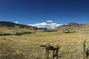
Photos of the Columbia Basin

Coulee country at Dry Falls—cathedral-scale cliffs left by Ice Age megafloods—illustrates the Basin’s stark, sculpted beauty.
Physical Features
Area: ~260,000 km² for the broader Columbia Plateau; the dry Columbia Basin core covers a substantial portion of central and eastern Washington
Length: ~700 km (northwest–southeast across the broader plateau)
Width: ~300–400 km (variable by sub-basin)
Elevation: Generally 200–1,500 m above sea level; basalt mesas and broad plains dissected by deep coulees and river canyons
The landscape is underlain by the Columbia River Basalt Group—layer upon layer of Miocene lava flows hundreds of meters thick.
Later, cataclysmic Pleistocene floods scoured the rock into today’s channeled scablands, pothole lakes, and cliff-rimmed amphitheaters.
Climate & Precipitation
Temperature: Hot, dry summers often reach 35–40 °C; winter lows can dip below −15 °C in cold snaps
Precipitation: Typically 150–300 mm annually across the driest interior; most falls in late fall to spring, with summer thunderstorms rare but dramatic
Shielded by the Cascades, the Basin sits in a pronounced rain shadow. High evaporation and persistent summer sun produce classic desertlike conditions even without dunes.
Where irrigation is absent, water is the limiting factor for plants, wildlife, and people alike.
Ecological Features
Ecozone: Nearctic (temperate shrub-steppe and grassland transition)
Biome: Temperate shrub-steppe and semi-arid grassland
Ecoregions: Columbia Plateau / Columbia Basin Shrub-Steppe; Palouse Prairie transition; Channeled Scablands
This is sagebrush country. Native bunchgrasses stitch the soil between shrubs, and biological soil crusts—living films of lichens, mosses, and microbes—help lock dust and nutrients in place.
Flora & Fauna
Flora: Big sagebrush (Artemisia tridentata), gray and green rabbitbrush (Ericameria, Chrysothamnus), bitterbrush (Purshia tridentata), greasewood (Sarcobatus), and bunchgrasses such as bluebunch wheatgrass (Pseudoroegneria spicata) and Sandberg bluegrass. Spring brings short-lived wildflower displays—balsamroot, lupine, and phlox—after winter moisture.
Fauna: Mule deer, coyote, badger, black-tailed jackrabbit, Townsend’s ground squirrel, and various small mammals.
Reptiles include gopher snakes and western rattlesnakes; wetlands and river corridors host beaver, muskrat, and waterfowl.
Birdlife is a standout: ferruginous hawk, Swainson’s hawk, burrowing owl, long-billed curlew, sage thrasher, horned lark, and remnant populations of greater sage-grouse in select protected areas.
The Columbia Basin pygmy rabbit—North America’s smallest rabbit—is a conservation icon tied to intact sagebrush.
Geology & Notable Features
Geology: The Columbia River Basalt Group (Miocene flood basalts, ~17–6 Ma) forms the bedrock.
During the last ice age, repeated outburst floods from Glacial Lake Missoula blasted across the plateau, carving coulees, cataracts, and potholes—collectively the Channeled Scablands.
Notable Features: Dry Falls (one of the world’s largest fossil waterfalls), Grand Coulee and the Columbia Basin Project irrigation works,
Hanford Reach National Monument (the last free-flowing reach of the Columbia River in the U.S.), Drumheller Channels, Frenchman Coulee, Palouse Falls State Park, and vast shrub-steppe reserves protecting sage-grouse and pygmy rabbit habitat.
Today, the Basin juxtaposes wild scablands with one of North America’s most productive irrigated farm belts—orchards, vineyards, hops, wheat, and potatoes flourish where water is delivered.
Visiting the Columbia Basin
Spring and early fall are prime: cooler temperatures, wildflowers, and migratory birds. Summer heat demands preparation—carry ample water, sun protection, and a map.
Respect fragile soil crusts and seasonal closures that protect nesting raptors and grouse leks. Many of the most dramatic viewpoints are roadside or short hikes from parking areas.
Conservation & Land Use
Native shrub-steppe has declined due to cultivation, invasive grasses, altered fire regimes, and development.
Conservation priorities focus on large, connected sagebrush blocks, riparian restoration, and fire-wise management to protect species like the greater sage-grouse and the Columbia Basin pygmy rabbit.
Public lands, tribal nations, private landowners, and conservation groups coordinate to balance agriculture, clean energy, and biodiversity.
Introduction
The Columbia Basin is a geographic region in the Pacific Northwest of the United States with features similar to desert landscapes. Although it is not a desert in the strict sense, parts of the basin share the dry climate and ecosystems typical of arid regions. This section examines its physical features, climate, and ecosystems, and compares them with those of other desert environments.
Geography
The Columbia Basin spans parts of Washington, Oregon, and Idaho, covering an area of approximately 2,500 square miles. Its geographical features include rolling hills, rocky outcrops, and several lakes, including Lake Roosevelt and the Columbia River, which traverses the basin. The elevation ranges from about 400 to 1,000 feet above sea level, creating a valley between the rugged Cascade Range and the Blue Mountains.
Climate
The climate in the Columbia Basin is classified as semi-arid, with distinct variations throughout the region. Average annual precipitation is around 8 to 16 inches, mostly falling in the winter months, while summers are typically hot and dry. This climate provides the necessary conditions for the development of unique ecosystems that resemble desert flora.
Vegetation and Ecosystem
Despite its semi-arid conditions, the Columbia Basin boasts an array of vegetation. The basin is home to various sagebrush species, drought-resistant grasses, and some juniper trees. One of the most notable areas is the Hanford Reach, where a diverse collection of flora supports local wildlife, including the white-tailed deer and over 300 species of birds.
Comparison with Other Deserts
A comparison with other deserts helps place the Columbia Basin in context. The table below outlines the main characteristics.
| Desert | Location | Area (sq mi) | Climate Type | Average Precipitation (in) | Notable Flora |
|---|---|---|---|---|---|
| Sahara Desert | Africa | 3,600,000 | Hot desert | 3-7 | Cacti, date palms |
| Mojave Desert | USA (California, Nevada) | 47,877 | Hot desert | 3-10 | Joshua trees, creosote bushes |
| Columbia Basin | USA (Washington, Oregon, Idaho) | 2,500 | Semi-arid | 8-16 | Sagebrush, bunchgrass |
Economic Importance
The Columbia Basin is more than just a geographical feature; it plays a critical role in the economy of the region. Agriculture thrives here thanks to the irrigation systems developed from the Columbia River. Crops such as apples, grapes, and hops are prevalent, positioning the basin as a vital area for food production. The region is also known for its wine production, largely due to the favorable climate and fertile soil.
Conservation Efforts
Urban growth and agriculture place pressure on the Columbia Basin, leading to conservation efforts across the region. Organizations and local governments work to protect native habitats and restore damaged ecosystems. Current initiatives include preserving wildlife corridors and protecting water quality in the Columbia River.
Final Thoughts
The Columbia Basin does not match the typical image of a desert, yet it contains dryland ecosystems and distinct environmental features. Its climate, land use, and conservation efforts shape both its natural systems and regional economy. The Columbia Basin shows that desert environments can take different forms within the United States.
References
Government / Official Sources
- USGS — Channeled Scablands & Missoula Floods
- U.S. EPA — Ecoregions of North America (Columbia Plateau)
- USFWS — Hanford Reach National Monument
University & Research
- Washington State University — Shrub-steppe research highlights
- Oregon State University — Rangeland ecology & invasive species resources