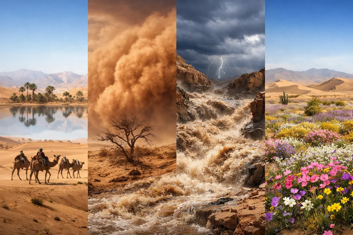
1 inventions in Desert Phenomena
Deserts look spare from far away. Stand inside one, and the picture changes fast. Light bends above heated ground. Dust lifts into walls that erase the horizon. Dry channels become torrents after a short storm. Then, weeks later, a plain that looked lifeless can turn green, yellow, or violet with flowers.
That contrast is not random. It comes from the same desert traits over and over again: low humidity, strong solar heating, thin or patchy plant cover, loose sediment, hard or crusted ground, and rain that is rare but often intense when it arrives. Put those traits together and you get a landscape that can be visually deceptive, meteorologically restless, hydrologically abrupt, and biologically patient.
So the real story of desert phenomena is not that deserts are empty. It is that deserts are high-contrast systems. They store energy, water, and seed life in scattered forms, then release them in short bursts. Seen that way, mirages, sandstorms, flash floods, and blooms all belong to one connected desert logic.
- Many deserts receive less than 250 millimeters of precipitation in a year, and some hyper-arid zones receive only a few millimeters.
- In very dry desert air, daytime heat can climb above 37–50°C, while nighttime temperatures may fall to 4°C or lower.
- Global sand and dust activity moves about 2 billion tons of dust into the atmosphere each year.
- More than 80% of the global dust budget comes from North African and Middle Eastern deserts.
- Recent wildflower examples show how small rainfall shifts matter: Death Valley’s fall of 2025 recorded 2.41 inches of rain, more than its usual yearly total, helping set up a strong bloom season in 2026.
| Phenomenon | Main Physical Trigger | What You Usually See | Typical Time Scale | Common Desert Settings |
|---|---|---|---|---|
| Mirages | Sharp temperature gradient in near-surface air that bends light | Shimmering “water,” floating horizons, stretched or inverted images | Minutes to hours | Roads, gravel flats, playas, dune fields, salt flats |
| Sandstorms and Dust Storms | Strong winds, gust fronts, thunderstorm outflow, exposed fine sediment | Dust wall, brown sky, low visibility, drifting sand | Minutes to days | Dry basins, alluvial fans, lake beds, desert margins, open plains |
| Flash Floods | Short, intense rain that exceeds infiltration and rushes through channels | Sudden muddy flow in dry washes, wadis, arroyos, slot canyons | Minutes to several hours | Mountain fronts, wadis, canyons, bajadas, urban desert edges |
| Desert Blooms | Enough rain, good soil moisture, suitable warmth, and living seed banks | Mass flowering of annuals and perennials, fast greening, pollinator surges | Weeks to a few months | Alluvial fans, foothills, basins, fog deserts, winter-rain deserts |
Why Deserts Produce Such Sharp Contrasts
A desert is not defined by sand. It is defined by dryness. That matters because dryness changes almost everything else: how air behaves, how soil takes in water, how plants survive, how surface heat rises, and how far wind can move loose grains. In simple terms, aridity sets the rules.
Low Humidity and Clear Skies
Desert air usually holds little water vapor, and skies are often cloud-poor. With so little atmospheric moisture, the sun heats the ground quickly during the day. The surface warms the air above it, and that near-ground air can become very hot relative to the layers above. This is why mirages are common over roads, gravel, and salt-crusted flats. The optical path of light becomes unstable. The land looks wet. It is not.
The same dry air also helps heat escape after sunset. So deserts often show large diurnal temperature ranges, which is just the technical way of saying the difference between daytime and nighttime temperature can be wide. In some hot deserts, daytime air can exceed 37°C, while night temperatures fall near freezing. Rare are the landscapes where the same 24-hour cycle can feel this different.
Sparse Vegetation and Exposed Sediment
Where plant cover is thin, the ground is more exposed to wind. There are fewer roots to hold fine sediment in place and fewer stems to slow near-surface airflow. That opens the door for aeolian processes—wind-driven movement of sand, silt, and dust. Coarser sand usually stays low and hops forward in short jumps, while finer dust can stay aloft longer and travel far beyond the source basin.
This is why the same desert can look calm at ground level and still feed a regional dust plume. It also explains why desert margins and dry lake beds often matter so much. Fine sediment tends to gather there. When strong winds arrive, those surfaces are ready.
Hard Ground, Short Storms, and Fast Runoff
People often assume dry ground will absorb water easily. In many deserts, the opposite happens. Surface crusts, compacted sediment, clay-rich patches, rock outcrops, steep slopes, and sparse vegetation all help rainfall turn into runoff fast. Add a narrow canyon or a dry wash, and a short storm can become a flash flood before the sky overhead even looks dramatic.
This is one of the most misunderstood parts of desert geography. A place can be dry for months, then flood in minutes. Not contradictory. Entirely desert-like.
Seed Banks Waiting Below the Surface
Not every desert plant waits above ground. Many annual wildflowers wait below it. Their seeds remain dormant in soil until rainfall, temperature, and timing line up well enough for germination. In places like Death Valley, the Sonoran Desert, Namaqualand, and the Atacama, that hidden seed bank is the quiet half of every bloom story.
Some years bring scattered flowers. Some years bring dense coverage over fans and foothills. The difference is usually not magic and not luck alone. It comes from rain spacing, soil moisture retention, warmth, wind conditions, and whether a living seed bank survived the long dry run before the storm season. That timing maters because desert annuals cannot waste a false start.
Desert Mirages: Why Dry Land Looks Like Water
Mirages are among the best-known desert phenomena, yet they are still described badly. A mirage is not a hallucination. It is a real optical effect caused by refraction, the bending of light as it moves through air layers with different temperatures and densities.
How a Mirage Forms
On a hot day, the ground heats the air directly above it. That near-surface air becomes warmer and less dense than the air a little higher up. Light passing through these layers bends. When the bend is strong enough, the eye interprets the shifted light as a reflection-like surface. This is why a road or playa can look like it holds a sheet of water in the distance.
The classic desert road mirage is an inferior mirage. “Inferior” here means the false image appears below the actual object or horizon line. It often looks blue because what you are really seeing is distorted sky light bent upward near the surface. The mind reads it as water because that is the nearest familiar visual match.
What the Eye Is Really Reading
- Hot surface: sand, dark rock, road tar, or salt crust warms fast under direct sun.
- Density gradient: hotter air below, cooler air above.
- Refraction: light curves while crossing those layers.
- False surface cue: the sky is bent into the observer’s line of sight and resembles reflected water.
Inferior Mirages and Superior Mirages
Most people in hot deserts notice inferior mirages, especially on roads, gravel flats, and broad valley floors. Yet deserts can also produce superior mirages when cooler air sits below warmer air in a temperature inversion. In that case, distant objects may appear raised, stretched, or even layered. The more elaborate forms are often grouped under the name Fata Morgana.
Hot desert basins, salt flats, and wide dry coasts can all produce these effects under the right atmospheric setup. They are less common than the water-like shimmer on a hot road, but they matter because they show that desert optics are not a single trick. They are a family of light-bending effects tied to vertical air structure.
Why Mirages Are So Common in Deserts
Deserts are ideal mirage country for four simple reasons:
- Strong incoming sunlight heats the surface fast.
- Low humidity allows large near-ground temperature contrasts.
- Wide open sightlines let the eye track long, low horizons.
- Flat reflective-looking terrain such as playas, salt pans, and roads makes the illusion more convincing.
Mirages show up especially well in places like the Sahara, Arabian Desert, Mojave, and salt flat landscapes such as Salar de Uyuni and the Great Salt Lake Desert. Not every case is identical, though. Surface color, wind, cloud cover, and viewing angle all change the effect.
The Science Behind the “Water on the Road” Illusion
When drivers see a glossy patch ahead, the illusion often seems to retreat as they approach. That happens because the angle needed to see the refracted sky shifts with the observer’s position. Move forward, and the geometry changes. The “pool” moves too. It has no fixed edge because it is not a surface feature at all.
That is why mirages are such a good lesson in desert reading: they are visual events created by atmosphere, not by ground moisture. A desert can look wet precisely because it is dry and hot enough to bend light this way. Strange, but exact.
Mirages and Human Perception
In practical terms, mirages matter because they show how far visual interpretation can drift in arid landscapes. Deserts simplify the horizon, reduce landmarks, and create strong glare. Under those conditions, the brain leans hard on pattern recognition. A shimmering blue patch becomes “water.” A stretched ridgeline becomes a lake margin. A distant object seems nearer than it is.
That does not make desert vision unreliable all the time. It simply means the atmosphere is part of the view. In humid landscapes, you often look through the air. In deserts, sometimes you are also looking at what the air is doing.
Sandstorms and Dust Storms: Wind in Visible Form
If mirages make the desert look like water, sandstorms and dust storms make wind visible. They begin when strong airflow lifts loose sediment from dry ground. That sounds simple. The details are not.
Sand Is Not Dust
People often use the two words as if they mean the same thing. In desert science, they overlap but are not identical. Sand is coarser and usually moves near the ground by short hops and rolling. Dust is finer, rises higher, stays airborne longer, and can travel much farther.
That difference matters for how storms look and how they spread. A low, abrasive cloud near the surface often contains more sand. A broad atmospheric plume crossing seas or continents is dust-dominated. In many real storms, both occur together. Even so, the balance between them changes the character of the event.
| Wind-Blown Material | Typical Behavior | Where It Moves | What It Does to Visibility | Landscape Clue |
|---|---|---|---|---|
| Coarse Sand | Short hops, rolling, bouncing close to the ground | Usually local to regional | Can create low, dense, abrasive near-surface conditions | Dunes, sand sheets, dry sandy plains |
| Silt and Fine Dust | Suspends more easily and remains aloft longer | Regional to intercontinental | Can produce broad haze or near-zero visibility in intense cases | Dry lake beds, floodplains, disturbed crusts, desert margins |
| Mixed Dust Wall | Often lifted by gust fronts or convective outflow | Fast-moving storm edge | Visibility collapses quickly | Haboob-prone monsoon deserts |
How Desert Winds Start Moving Sediment
Wind must overcome the forces holding grains in place. That includes gravity, grain roughness, soil moisture, crust strength, and whatever plant cover exists. Once the first grains begin to hop—a process called saltation—they can strike other grains and start a chain reaction. The surface becomes active. More grains move. Fine dust lifts into the air above the saltating layer.
That is why surface condition matters as much as wind speed. A desert with compacted, crusted ground may resist erosion for a while. Break that crust through trampling, drought stress, vehicle disturbance, overgrazing, or floodplain drying, and the same wind can raise far more dust.
Haboobs: The Fast Face of a Desert Dust Storm
One of the most dramatic dust-producing setups is the haboob. This is a dust or sand storm generated by thunderstorm downdrafts and the outflow they create at the surface. In plain language: a storm collapses, cool dense air drops and rushes outward, and that gust front plows into loose desert sediment. Up goes the dust wall.
Haboobs are common in arid and semi-arid areas with convective storms, including parts of Sudan, the Arabian Peninsula, and the American Southwest. Some rise several thousand feet high and stretch for miles. Many arrive quickly. The wall itself is what people remember, but the real engine is the outflow boundary.
The desert paradox shows up again here: thunderstorms help make dust storms. Rain and dust are not opposites in these systems. They are sometimes neighbors in the same event.
Where the Biggest Dust Sources Tend to Be
Not all deserts produce the same amount of dust. The strongest global sources often come from dry basins, lake beds, and fine-sediment surfaces rather than dune seas alone. The Sahara and adjacent drylands dominate the global picture, and North African plus Middle Eastern sources account for most of the world’s dust budget.
That helps explain why Saharan dust can cross the Atlantic, why Arabian dust can affect the eastern Mediterranean, and why arid inland basins in Asia feed dust outbreaks far downwind. Desert dust is not merely local weather. It can become part of the planetary atmosphere for a while.
What Sandstorms Do to a Desert Landscape
Windstorms do more than darken the sky. They sort surfaces. They strip fines from one place and deposit them in another. They shape ripples and dunes, abrade exposed rock, bury small seedlings, and leave coarse lag behind on deflated ground. Over time, wind helps produce desert pavement, dune fields, sand sheets, and cleaner exposures of rock or gravel.
In this sense, a dust storm is not just weather. It is also geomorphic work. Deserts get carved by water in bursts and edited by wind in between.
Health, Travel, and Air Quality
Dust storms also matter because fine mineral particles affect visibility and breathing. Roads close. Flights divert. Solar panels lose efficiency under dust loading. Urban areas downwind can see air quality worsen even when the storm formed far away. This wider reach is one reason sand and dust storms affect billions of people around the globe, not only those living inside desert cores.
The common image is a camel in blowing sand. Real desert dust geography is broader than that. Port cities, mountain snowpack, cropland, highways, power systems, and distant coastlines all sit inside the longer path of desert aerosols.
Flash Floods: Why a Dry Desert Can Flood So Fast
Flash floods are among the least intuitive desert phenomena. To many people, flood means a wet climate and a large river. Desert flood means something else: short-lived, high-energy runoff triggered by intense rainfall, often in channels that looked harmless hours earlier.
Why Dry Ground Often Sheds Water
When a storm drops rain faster than soil can absorb it, water begins to run over the surface. In deserts, that threshold is often crossed quickly. The reasons vary by place:
- Surface crusts can slow infiltration.
- Clay-rich layers can swell and reduce intake.
- Rock outcrops send water downslope almost at once.
- Sparse plants leave fewer stems and roots to slow runoff.
- Steep mountain fronts and narrow channels focus flow.
So yes, desert soil can be dry and still flood fast. The issue is not whether the ground is thirsty. The issue is whether it can take in water at the rate the storm delivers it.
Arroyos, Wadis, Washes, and Ephemeral Streams
Many desert channels are ephemeral, meaning they flow only after rain. Regional names differ. In the American Southwest, you often hear arroyo or wash. In North Africa and Southwest Asia, wadi is common. The hydrologic pattern is the same: a channel stays dry much of the year, then carries water suddenly and with force.
These channels are easy to underestimate because their quiet phase lasts longer than their active phase. Gravel beds, smooth banks, and broad sandy bottoms do not feel like moving-water landforms when the sky is blue. Yet that is exactly what they are.
Water in deserts rarely gets a long, slow route. When it comes, it often races through prepared pathways. A dry channel is not a failed river. It is a river on pause.
Rain Does Not Need to Fall Right Over You
This is the other big misconception. Desert flash floods can be triggered by rain far upstream. A storm over a mountain catchment may send a surge down a canyon even while lower ground remains dry or only lightly wet. In slot canyons, narrow gorges, and fan-head trenches, that lag between cause and effect can be short enough to surprise anyone reading only the local sky.
That is why desert hydrology is so tied to catchment scale. A wash is a downstream answer to an upstream question.
How Floodwater Changes the Landscape
Flash floods in deserts are not gentle. They can move mud, gravel, branches, cobbles, and even boulders in confined terrain. They cut fresh channels, undercut banks, sort sediment by size, spread sheets of debris over fan surfaces, and carve or deepen arroyos. Over repeated events, they shape alluvial fans, bajadas, slot canyons, and fan-toe deposits.
The same flood that looks brief on a weather map may leave a geomorphic mark for years. That is one reason so many iconic desert landforms are really the product of intermittent water, not only wind.
Why Desert Floods Feel So Sudden
Storm cells can be localized, rainfall rates can be high, and channels are often narrow. Water therefore concentrates quickly and rises fast.
Why They Carry So Much Mud
Dry hillslopes, loose sediment, sparse roots, and steep gradients make erosion easy once runoff begins.
Why Wadis Matter
Wadis record old flows, route new flows, and often feed fan building, groundwater recharge, and short-term wetland patches.
Why Flood and Drought Can Sit Together
A long dry spell can coexist with one violent rain event. Climate state and storm event are not the same thing.
Desert Flood Examples That Show the Pattern Clearly
The Atacama Desert offers one of the clearest modern examples. In 2015, parts of northern Chile saw roughly 50 millimeters of rain during a major event. By global standards that is not an extreme multi-day total. In one of the driest regions on Earth, it was enough to trigger destructive flooding and mudflows. Antofagasta received about 24 millimeters in a day, roughly 14 years of its average annual rain.
The pattern repeated in another form in the Atacama during 2019, when foothill stations measured 100–200 millimeters in places along the Andes-facing side, producing damaging floods and later visible greening. It is a useful reminder that hyper-arid deserts are not rain-proof. They are event-sensitive.
The Sahara also showed this dramatically in 2024, when unusual rainfall brought temporary water and a sharp rise in vegetation greenness in areas that are usually barren. Satellite comparisons made the shift easy to see. The flood signal was not just water in channels. It was water written across the surface itself.
Flash Floods and Desert Cities
Urban growth in desert regions adds another layer. Roads, roofs, parking surfaces, channels, and storm drains alter where water goes and how fast it gets there. Even where rainfall totals remain low on a yearly basis, built surfaces can amplify runoff during short storms. This is why desert-edge cities often spend so much effort on flood control basins, diversion channels, culverts, and fan management.
Desert hydrology may look simple on a climate chart. On the ground, it is anything but simple.
Desert Blooms: Why Arid Landscapes Burst Into Flowers
Of the four phenomena in this pillar topic, desert blooms are the most biologically layered. A flood can happen in one day. A bloom begins before the rain arrives, because the seeds, bulbs, roots, and dormant tissues are already in place. The visible flowers are only the last phase of a long waiting game.
The Hidden Seed Bank
Many desert annuals avoid drought not by enduring it above ground, but by waiting it out as seeds. In good years they sprout, flower, set seed, and disappear back into the soil. In poor years they remain dormant. This strategy makes sense in a climate where rainfall is patchy, seasonal timing matters, and a fast life cycle is often safer than trying to hold green tissue through months of dryness.
That is why bloom years can feel sudden to visitors. The plants did not arrive overnight. They were already there as a soil seed bank, sometimes for years, waiting for moisture and temperature to line up.
What Usually Triggers a Good Bloom
Rain alone is not enough. In well-known bloom regions such as Death Valley, better bloom years usually depend on a mix of conditions:
- Enough rain to wet the germination zone.
- Rain spaced across the cool season, not just one brief downpour.
- Suitable temperature after germination.
- Not too much drying wind while seedlings are small.
- A living seed bank with enough viable seeds in the soil.
Miss one of those and the season may produce only scattered flowers. Hit several together and the ground can fill with color. The difference between a thin bloom and a famous bloom is often in the spacing, not just the total amount, of rainfall.
Why Blooms Often Follow Disturbance or Rare Wet Years
Desert annuals are built for pulse ecology. They respond to temporary resource pulses—especially soil moisture. In many places, a rare wet winter or unusual storm sequence pushes enough water into near-surface soils for seeds to break dormancy. Once seedlings emerge, the race begins. They must grow, flower, attract pollinators, and set seed before heat and drought close the window.
That short cycle is why desert blooms feel both lush and fragile. They are lush because density can rise fast. Fragile because the window is brief.
Death Valley: A Clean Example of Bloom Logic
Death Valley is famous for bloom years because the contrast is so sharp. Most showy wildflowers there are annual ephemerals. They stay dormant as seeds during harsh years. When enough rain falls, they sprout and move quickly through a short life cycle.
Bloom timing also shifts with elevation. Lower elevations often flower first from mid-February to mid-April. Higher slopes and valleys may bloom later into April and early May. That staggered timing is one reason visitors can misread bloom reports. A desert can be “past peak” in one elevation band and just starting in another.
Recent rainfall in late 2025 made this pattern visible again. Death Valley logged its wettest fall on record, with 2.41 inches of rain from September through November, setting up better-than-usual moisture for the following spring. Even there, though, heavy rain is only part of the bloom recipe. Temperature and wind still decide how much of the seed bank turns into a floral display.
The Atacama and the “Desierto Florido”
The Atacama Desert offers another famous bloom story. It is one of the driest places on Earth, with some parts receiving just a few millimeters of rain in a year and some zones nearly none at all. Yet after unusual rain, especially on the Chilean side where moisture reaches the right ground and season, the desert can green and flower across wide areas. This event is widely known as the desierto florido, the flowering desert.
That bloom is not just a pretty surprise. It is a biological signal that moisture moved through a system built to respond to rare pulses. In the Atacama, bloom years are tied to unusual rainfall patterns, often shaped by broader ocean-atmosphere conditions. After the floods of 2019, satellite data also showed greener-than-normal vegetation across parts of the region.
Namaqualand, the Sonoran Desert, and Other Bloom Regions
The best-known desert flower displays are not limited to North and South America. Namaqualand in southern Africa becomes well known in wetter years because winter rain and spring warmth can turn arid plains into fields of daisies and other annuals. In the Sonoran Desert, winter rain supports annuals while many cacti and shrubs add flowering sequences later in the year. In parts of Australia’s arid interior, inland flower flushes follow episodic rains that recharge shallow soils.
So there is no single bloom model. Some deserts rely more on winter rain. Some depend on monsoon timing. Some lean on fog and dew as minor helpers, though rain still does the main work for large annual displays. The principle remains the same: dormancy plus pulse moisture.
Pollinators, Timing, and Seed Return
A bloom is not just about flowers. It is also about the short reopening of desert food webs. Bees, butterflies, moths, flies, birds, and small mammals respond to nectar, pollen, seeds, and fresh vegetation. In good bloom years, pollinators can appear in higher numbers and move farther across the landscape because the floral reward justifies the trip.
That matters because a bloom is only successful in ecological terms if it returns seed to the soil. A desert annual’s job is not to stay green. Its job is to make the next waiting generation.
How the Four Phenomena Connect
The easiest way to miss the desert is to treat mirages, dust storms, flash floods, and blooms as four separate curiosities. They are not. They are linked by the same surface-energy and moisture regime.
One Dry Surface, Many Outcomes
A hot, bare surface can create the near-ground thermal gradient needed for a mirage. The same bare surface, if fine sediment is exposed, can feed dust into strong winds. The same sparse cover and crusted soil can speed runoff once intense rain begins. The water from that storm can then recharge shallow soils just enough to wake annual seeds. Same landscape. Different response windows.
Think of it as four clocks running at once:
- Mirage clock: minutes, controlled by surface heating.
- Dust clock: minutes to days, controlled by wind and sediment supply.
- Flood clock: minutes to hours, controlled by storm intensity and channel routing.
- Bloom clock: weeks to months, controlled by stored biological potential after moisture arrives.
The clocks are separate in timing, but they share the same desert engine.
Thunderstorms Link Dust and Floods
One of the strongest links appears during convective storm seasons. A thunderstorm can throw out a gust front before the heaviest rain arrives at lower elevations. That gust front raises dust—sometimes as a haboob. Later, rainfall in uplands sends water through washes and canyons. Dust storm first. Flash flood next. In monsoon deserts, this sequence is not odd. It is classic.
In some years, the moisture delivered by repeated storms then supports later flowering. That means the same storm season can produce all four themes of this pillar topic, only on different time scales.
Floods and Blooms Are Not Opposites
People often imagine flood as destruction and bloom as beauty, as if one cancels the other. In deserts, both can come from the same moisture pulse. A storm can strip channels, move debris, and still leave enough water in alluvial fans, benches, and shallow soils to support later growth. The location matters. So does intensity. But the pairing is normal.
This is one of the content gaps many short articles miss. They explain blooms without the hydrology, or floods without the ecology. Real deserts do both at once.
Mirages and Blooms Also Share a Climate Story
The hottest, driest days after a bloom season can still produce strong mirages because low humidity returns surface heating to center stage. In other words, the desert does not stop being a thermal landscape just because it briefly turned floral. The flowers occupy the same energy-rich setting that later dries them back into seed.
Green does not cancel arid. It only interrupts it.
Major Desert Regions and Their Signature Phenomena
| Desert Region | Mirages | Sandstorms and Dust | Flash Floods | Blooms and Greening |
|---|---|---|---|---|
| Sahara | Common over flats, roads, and heated surfaces | Global dust giant; major source region for long-range transport | Localized but powerful after rare heavy rainfall and upland storms | Short-lived greening after unusual rain, especially in depressions and margins |
| Atacama | Strong optical effects over dry flats and heated basins | Less famous for giant dust transport than the Sahara, but active in exposed basins | Exceptional flood response to rare rain due to extreme aridity | Famous flowering desert after unusual rainfall events |
| Mojave and Sonoran | Classic road and basin mirages | Haboobs and dust walls tied to monsoon outflow in parts of the Southwest | Arroyos, slot canyons, fan floods, urban runoff issues | Strong annual displays in wetter winters and after well-spaced rains |
| Arabian Desert | Frequent over heated plains and roads | Major dust activity, including regional transport | Wadi flooding after intense rain events | Short green response in favored years and topographic pockets |
| Namib and Namaqualand Zone | Possible over gravel plains and coastal heat gradients | Wind activity strong, especially with coastal influence | Ephemeral drainage can activate after rain | World-famous flower years under the right winter rain pattern |
| Australian Arid Interior | Common over roads and salt lakes | Dust outbreaks from dry basins and inland plains | Ephemeral rivers and inland floodouts after rain pulses | Large inland flower flushes after episodic rains |
The Technical Side of Desert Phenomena
A pillar page should do more than describe what people see. It should also explain the technical language that desert scientists, meteorologists, hydrologists, and ecologists use when they measure these events.
Refraction and Temperature Gradient
In mirage science, the working terms are refraction, air density, and temperature gradient. Warmer air is less dense than cooler air. Light bends as it passes through those layers. In deserts, strong surface heating makes the near-ground gradient steep enough to produce visible distortion. That is why mirages often strengthen late in the morning and through the hotter part of the afternoon.
Saltation, Suspension, and Surface Roughness
In wind erosion science, three words matter a lot:
- Saltation: grains hop forward in short leaps.
- Suspension: finer particles stay aloft in the air column.
- Surface roughness: vegetation, stones, and microtopography that slow wind and shield sediment.
Dust and sand particles range from sub-micron sizes to several hundred microns. Smaller particles lift more readily and stay airborne longer. Coarser grains usually travel shorter distances and remain close to the surface. This is why the visual face of a storm can differ so much from the long-range transport story above it.
Infiltration, Runoff, and Ephemeral Flow
In flood science, the core terms are infiltration, runoff, catchment, and ephemeral stream. Infiltration is water entering the soil. Runoff is water moving over the surface or through channels. Catchment means the whole area draining toward one channel. Ephemeral means the stream does not flow year-round.
When rainfall intensity rises above infiltration capacity, excess water becomes runoff. In deserts, that threshold can be crossed quickly, especially on steep, crusted, rocky, or urbanized ground. Once channels are active, they can rise fast because upstream water is being concentrated into smaller flow paths.
Seed Dormancy, Germination Window, and NDVI
In bloom ecology, the useful terms are seed dormancy, germination window, ephemeral annual, and NDVI. NDVI stands for Normalized Difference Vegetation Index, a satellite-based measure of greenness. When deserts green after rain, satellite NDVI often rises sharply above its long-term average. That is one reason bloom events and post-rain greening are now easier to track at regional scale.
From above, a bloom is not just color. It is a temporary change in the desert’s spectral signature.
What Many Short Articles Miss About Desert Phenomena
Short explainers often do a decent job with the headline event and then stop. The desert deserves more than that. Three ideas are especially worth adding because they help readers move from trivia to real understanding.
Deserts Are Not “Empty” Between Events
A dust storm is not the only active phase. Between storms, fine sediment is being sorted. Between floods, channels are storing evidence. Between blooms, seeds are waiting. Between mirages, the surface is still building the next thermal gradient. The visible event is brief; the setup is long.
Water Is a Desert Architect Even Where Rain Is Rare
Many people assign wind most of the visible desert work. Wind matters a great deal. Yet flash floods carve channels, sort fan sediments, build wash terraces, recharge some aquifers, and even help create later bloom conditions. Rock arches and dune ridges may capture attention, but ephemeral water does much of the structural editing.
The Same Storm Season Can Produce Opposite-Looking Results
One season can bring dust walls, muddy floods, temporary lakes, and flower fields. That sounds contradictory only if desert systems are imagined as static. Once deserts are understood as pulse-driven environments, the pattern makes sense. Events that seem unrelated are often neighbors in time.
Reading a Desert Landscape Through Its Phenomena
A broad desert basin at noon tells you one story. A mountain-front wash after rain tells another. A flowering alluvial fan tells another still. Read together, they reveal a coherent landscape language.
If You See Shimmering Distance
You are probably reading surface heat, low humidity, and a strong near-ground thermal contrast. The atmosphere is shaping the view.
If You See Dust Rising From a Basin Edge
You are likely reading fine sediment supply, bare ground, and wind strong enough to trigger transport. The surface is becoming mobile.
If You See a Dry Wadi With Fresh Debris Lines
You are reading recent flow, even if no water remains. Desert floods leave traces in driftwood, mud lines, sediment sorting, and trimmed vegetation.
If You See Flowers Spread Across Fans or Foothills
You are reading stored biological memory. That bloom is the surface expression of earlier rain, viable seeds, and a climate window that opened just long enough.
Put all of that together, and the desert stops looking empty or monotonous. It becomes legible. Mirages show the air. Sandstorms show the wind. Flash floods show hidden drainage. Blooms show life stored below sight. A desert may seem still at first glance, yet still it is only in the briefest sense.
That is why these four phenomena belong on the same page. They are not side notes to desert geography. They are four of the clearest ways a desert explains itself.