Cabo de Gata-Níjar Natural Park
Location & Continent Continent: Europe Country: Spain Region: Andalusia, Province of Almería Coordinates: 36°50′N, 2°11′W Photos of Cabo...
Read More →Monegros Desert
Location & Continent Continent: Europe Country: Spain (Aragón region, between Zaragoza and Huesca provinces) Coordinates: 41°30′N, 0°15′W Photos...
Read More →Oleshky Sands (Oleshky Desert)
Location & Continent Continent: Europe/Asia (Ukraine) Country: Ukraine Coordinates: 46°37′N 34°57′E Photos of the Oleshky Sands Physical Features...
Read More →Tabernas Desert
Location & Continent Continent: Europe Countries: Spain Coordinates: 37°N, 2°W Photos of the Tabernas Desert Physical Features Area:...
Read More →Bardenas Reales
Location & Continent Continent: Europe Country: Spain Region: Southeast of Navarre, near Tudela Coordinates: 42°06′N, 1°30′W Photos of...
Read More →5 inventions in Europe
Europe is not the first continent people picture when they hear the word desert. They think of the Sahara, the Arabian Peninsula, or the Atacama. Yet Europe does have arid ground, dune fields, badlands, saline basins, and sub-desert coastlines that fit the story of dry landscapes shaped by water shortage, wind, salt, and erosion. Some are true deserts in climatic terms. Others are semi-desert or desert-like regions whose soils, landforms, and plant life still feel unmistakably dry-country.
This page focuses on five of the most discussed European desert regions: Tabernas Desert, Bardenas Reales, Cabo de Gata-Níjar Natural Park, Monegros Desert, and Oleshky Sands. Together they show that European aridity is not one single thing. It appears as gypsum badlands in Andalusia, an eroded semi-desert in Navarre, a volcanic dry coast on the Alboran Sea, saline steppe in the Ebro Basin, and a dune sea north of the Black Sea.
That difference matters. Too many articles flatten the subject into a simple list of “deserts in Europe” and stop there. The real picture is richer. Climate class, rock type, relief, drainage, salinity, and vegetation all shape how each region works. Small these regions may look on a world map, but geologically and ecologically they carry a lot of weight.
What Counts as a Desert in Europe?
A desert is usually defined by aridity, not by sand alone. Many deserts are rocky, gravelly, or clay-rich. In climate terms, the main question is simple: does the landscape receive so little effective moisture that plant cover stays sparse and water deficit dominates most of the year?
In Europe, that produces three broad categories:
- True desert climate zones, where annual rainfall is very low and evaporation pressure stays high. Tabernas is the most famous example on mainland Europe.
- Semi-desert regions, where rainfall is higher than in a classic hot desert, yet still low enough to support open steppe, saline flats, patchy scrub, and bare soil over wide areas. Monegros and Bardenas Reales fit here.
- Desert-like landscapes, where geology, wind, volcanic substrate, or dunes create a look and ecology close to deserts even when the local system is more accurately described as sub-desert, arid steppe, or semi-arid protected landscape. Cabo de Gata-Níjar and Oleshky Sands often enter the conversation through this route.
So, no, Europe is not covered in great sand seas. But yes, it has real drylands. And once the Atlantic influence weakens, or a basin traps dryness, or mountain barriers block moisture, the land starts to write its own arid script.
Why Europe Has So Few Deserts
The short answer is moisture. Much of Europe sits under the reach of the Atlantic westerlies, which deliver frequent frontal systems and a steadier water supply than the subtropical interiors of Africa, Arabia, or central Australia. Mountains intercept rain, rivers are dense, and temperate conditions keep many regions far above desert moisture thresholds.
Even so, local dryness can get intense. A rain-shadow setup, persistent summer drought, high solar radiation, porous or salty ground, and limited surface water can create dry-country conditions in surprisingly compact spaces. This is why Europe’s deserts are usually regional exceptions, not continent-wide patterns.
Southern Spain offers the clearest example. Parts of Almería sit behind mountain barriers that cut off moist air, and the result is a tight pocket of aridity with badlands, ramblas, and sparse scrub. The Ebro Basin tells a slightly different story: it is not as dry as a classic hot desert, but basin topography, saline soils, strong winds, high evapotranspiration, and irregular rain together produce a landscape that looks and behaves like a dry steppe on the edge of desert conditions.
Then there are the sandy systems. Oleshky Sands shows that a European desert region can arise not from Sahara-like heat, but from loose sand, low humidity, continental dryness, and wind-driven dune activity. Europe’s deserts are small laboratories of aridity. Different ingredients, same broad result.
European Desert Regions in One View
| Region | Country | Best Plain-Language Classification | Typical Dry-Land Markers | Why It Stands Out |
|---|---|---|---|---|
| Tabernas Desert | Spain | True desert climate on mainland Europe | Very low rainfall, badlands, sparse scrub, ramblas, intense summer heat | The clearest mainland European case for a hot desert climate landscape |
| Bardenas Reales | Spain | Semi-desert badlands | Scarce rain, ravines, mesas, cabezos, strong wind, open vegetation | One of Europe’s best badland landscapes, with strong erosion and striking relief |
| Cabo de Gata-Níjar Natural Park | Spain | Sub-desert coastal volcanic dryland | Low rainfall, volcanic rock, saline flats, dunes, xerophytic flora | Dry Mediterranean coast mixed with volcanic geology and marine influence |
| Monegros Desert | Spain | Semi-arid steppe desert region | Saline depressions, gypsum soils, steppe scrub, high evaporation | A dryland mosaic where wetlands, salt, and steppe ecology meet |
| Oleshky Sands | Ukraine | Sandy semi-desert dune field | Loose sand, low vegetation cover, continental dryness, wind-shaped dunes | One of Europe’s best-known inland sand landscapes |
Tabernas Desert: Europe’s Clearest Mainland Desert Case
When people ask whether Europe has a “real” desert, the conversation almost always lands on Tabernas Desert in southeastern Spain. That reputation is not just tourism language. Tabernas sits in the province of Almería, roughly 30 kilometers north of the city of Almería, in a basin framed by mountain ranges that reduce incoming moisture. The outcome is a landscape of badlands, gullies, ravines, dry channels, and pale sedimentary slopes that looks far drier than the European stereotype allows.
Technical data helps explain why. The protected desert area is often given as about 280 square kilometers, and widely cited rainfall values stay below 250 millimeters per year across much of the desert core. Average annual temperatures sit above 17°C, while summer highs can move well past 40°C. That blend of low precipitation and high thermal load drives a hard water deficit for long stretches of the year.
The landforms are classic badlands topography. Soft marls, clays, sandstones, and other erodible materials break down under episodic runoff. Because rain tends to arrive in short, sharp bursts rather than in a gentle pattern, water cuts into the ground fast. Rills become gullies; gullies become narrow ravines; broad slopes turn into dissected fans and terraces. The result is a place where erosion is easy to see with the naked eye.
Its dryness is not empty, though. Xerophytic and halophytic plants occupy niches where soil texture, groundwater traces, and slope orientation allow them to persist. Ramblas support greener strips when subsurface moisture lingers. Gypsum-related soils and stony surfaces create further microhabitats. Even small differences in exposure can matter a lot here.
Film history made Tabernas famous, but cinema should not overshadow the physical geography. This desert is also tied to research and environmental study. Nearby stands the Plataforma Solar de Almería, the largest concentrating solar technology research, development, and test center in Europe. That detail says a lot about the region: high insolation is not just a scenic trait here; it is measurable energy geography.
In European desert discussions, Tabernas does two jobs at once. First, it proves that mainland Europe can host a genuine desert climate pocket. Second, it shows that a desert does not need huge dunes to be convincing. Clay, marl, and badland incision can express aridity just as powerfully as sand. Quietly, that point gets missed a lot.
- Approximate protected desert area: about 280 km²
- Annual rainfall: often under 250 mm in the driest sectors
- Average annual temperature: above 17°C
- Dominant landform signal: badlands, gullies, ramblas, eroded slopes
Bardenas Reales: Semi-Desert Badlands in Navarre
Bardenas Reales in Navarre is not a desert in exactly the same sense as Tabernas, and that distinction matters. It is better read as a semi-desert badland system, one where low and irregular rainfall, strong drying winds, soft sedimentary rocks, and sparse plant cover combine to create a landscape that feels stark, open, and almost lunar in places.
The protected area is commonly described at around 42,000 hectares, though published figures vary a little depending on the administrative boundary being referenced. What does not vary is the visual message: this is one of Europe’s most striking erosion landscapes. Ravines cut through clay, chalk, and sandstone. Isolated hills, known locally as cabezos, rise above the surrounding ground. Plateaus and depressions sit side by side in a terrain where shape seems to be in constant negotiation with wind and runoff.
The internal division of Bardenas Reales helps make sense of it. Bardena Blanca is the most photographed sector, with pale soils, heavy erosion, and the sharpest badland scenery. Bardena Negra carries more pine and scrub and feels darker, denser, and less exposed. El Plano forms an elevated tableland used in part for cultivation. These three units show that even within one semi-desert, substrate, relief, and plant cover can shift the whole character of the land.
Rainfall here is scarce, irregular, and often torrential when it arrives. That rhythm is central. The ground can stay dry for long periods, then suddenly receive enough runoff to carve channels and reshape slopes. Wind, especially the dry regional air currents, adds another layer of abrasion and moisture loss. Little by little, the land is pared down.
Ecologically, Bardenas Reales is more than bare ground. Steppe birds, scrubland species, and halophytic plants use the mosaic of open flats, eroded hills, and saline conditions. Because the area links geomorphology with biodiversity so clearly, it works as a textbook example of how semi-desert structure controls habitat. A cliff face, a gypsum-rich slope, a flat plain, and a runoff line may look close together on a map; biologically, they are not the same at all.
Bardenas also corrects a common misunderstanding. Many readers assume a European desert region must mean endless sand. Here, the drama comes from sediment, erosion, and relief contrast, not from dune seas. If Tabernas explains desert climate, Bardenas explains desert process in a more sculptural way.
What Makes Bardenas Reales Different From Tabernas
- Climate Label: Bardenas is usually treated as semi-desert rather than a classic hot desert core.
- Visual Identity: Its famous landforms are mesas, ravines, and cabezos rather than the tighter badland basin feel of Tabernas.
- Internal Zonation: Bardena Blanca, Bardena Negra, and El Plano create a very clear three-part landscape pattern.
- Ecological Tone: It carries a stronger steppe-bird and semi-open scrubland character.
Cabo de Gata-Níjar Natural Park: Europe’s Volcanic Dry Coast
Cabo de Gata-Níjar Natural Park belongs in any serious discussion of European desert regions, even though it is not usually described as a classic inland dune desert. Its aridity is coastal, volcanic, and Mediterranean. That mix gives it a different feel from the dry basins farther inland.
Located in southeastern Spain along the Alboran Sea, the park is part of the most arid sector of the Iberian Peninsula. The biosphere reserve area is often cited at around 49,512 hectares. Rainfall is low and irregular, and some long-term figures from the area sit near 150–160 millimeters annually in the driest coastal points. That is a very lean water budget for Europe.
But what sets Cabo de Gata-Níjar apart most is geology. This is a volcanic landscape linked to the tectonic interaction of the African and European plates. The Cabo de Gata volcanic complex formed roughly 13 to 14 million years ago, and the terrain still displays domes, lava flows, dykes, fossil reef structures, coastal cliffs, and alluvial fans in a remarkably readable way. Few European drylands combine sub-desert ecology with volcanic geomorphology so clearly.
Plant life reinforces the distinctiveness. The area supports semi-arid Mediterranean shrubland, halophytic communities around saline flats, dune vegetation, and species with clear affinities to North African dry floras. The park is also known for the European fan palm, often described in UNESCO material as the only autochthonous continental European palm tree. That one detail says plenty about the climate tone here: dry, warm, sun-heavy, and ecologically unusual for Europe.
The coast matters too. Salt spray, marine humidity, cliff exposure, volcanic substrate, and local topography create a more layered dryland system than people expect. This is not an inland sand sea. It is a coastal arid mosaic made of beaches, coves, dunes, rocky slopes, lava-derived forms, and salt-influenced flats. The word desert still belongs in the conversation, but here it sits next to geopark, biosphere reserve, marine interface, and volcanic history.
Cabo de Gata-Níjar also helps fix another gap in many desert lists: they often separate “geology” from “desert landscape” as if they were different stories. In this park they are the same story. The shape of the coast, the dryness of the vegetation, the mineral colors, the cliffs, and the thin soils all come from that long volcanic inheritance.
- It expands the idea of desert: not just inland aridity, but coastal sub-desert.
- It links aridity to tectonics: volcanic forms are part of the dryland identity.
- It adds biodiversity depth: saline habitats, dunes, and xeric shrubland sit side by side.
- It shows how Europe’s driest ground can still be marine-facing: a useful correction to the usual “desert equals interior” assumption.
Monegros Desert: Saline Steppe and Gypsum Dryland in the Ebro Basin
Monegros Desert, in Aragón, is often introduced too quickly and understood too loosely. It is not a small copy of Tabernas, and it is not just “a dry place in Spain.” Monegros is best read as a semi-arid basin landscape where gypsum, salinity, steppe ecology, shallow depressions, and very high evaporative demand all work together.
The broader Monegros region spreads across parts of Zaragoza and Huesca within the central Ebro Basin. In the most studied dryland belt, published scientific work highlights a mean annual precipitation of roughly 346 millimeters, though values vary across stations and subareas. One of the most telling technical figures is not rainfall alone, but evapotranspiration. In research on the area, annual reference evapotranspiration has been placed near 1,255 millimeters. That gap between incoming water and atmospheric demand explains a lot.
The region is especially known for its saline wetlands, locally called saladas. Around 149 saline depressions or wetlands are often cited in the Monegros dryland system, and the total extent of these saline wetland areas has been measured in the thousands of hectares. This is where Monegros becomes really interesting. It is a dryland where “wetlands” and “desert process” are not opposites. They are neighbors.
Many of these basins are endorheic, meaning water does not drain outward to the sea. It pools, evaporates, and leaves salts behind. Over time, that builds saline soils, crusts, and plant communities adapted to water stress and mineral load. Gypsum-rich bedrock adds another layer. The land can look plain from a distance, yet chemically and ecologically it is full of sharp contrasts.
Monegros is also one of the best places in Europe to understand how semi-arid steppes function. Vegetation tends to be open and low, with drought-tolerant scrub, steppe grasses, and halophytic species where salinity rises. Bird life is part of the identity as well, especially in open-country habitats. This is not a vertical mountain ecology or a forest mosaic. It is a landscape of exposure, low cover, big sky, and horizontal structure.
Geomorphologically, Monegros does not rely on one “icon” landform the way Bardenas has Castildetierra or Tabernas has its cinematic badlands. Instead, its strength comes from pattern: broad dry plains, gypsum surfaces, saline hollows, shallow basins, and cultivated patches in tension with fragile soil systems. Subtle, yes. But also very exact.
Many articles miss this point and treat Monegros as a generic Spanish desert. That undersells it. The real story is the coupling of salinity, hydrology, soil chemistry, and steppe ecology. A place can be dry without being empty. Monegros proves it. In fact, its vegeation pattern only makes sense once soil salts and water balance enter the picture.
Monegros Technical Snapshot
- Setting: Central Ebro Basin, northeastern Spain
- Climate Tone: Semi-arid, drought-prone, high evaporation demand
- Mean Annual Precipitation in Core Studied Areas: about 346 mm
- Reference Evapotranspiration: around 1,255 mm in published research
- Notable Feature: about 149 saline wetlands or depressions
- Dominant Dryland Markers: gypsum-rich ground, saladas, steppe vegetation, saline soils
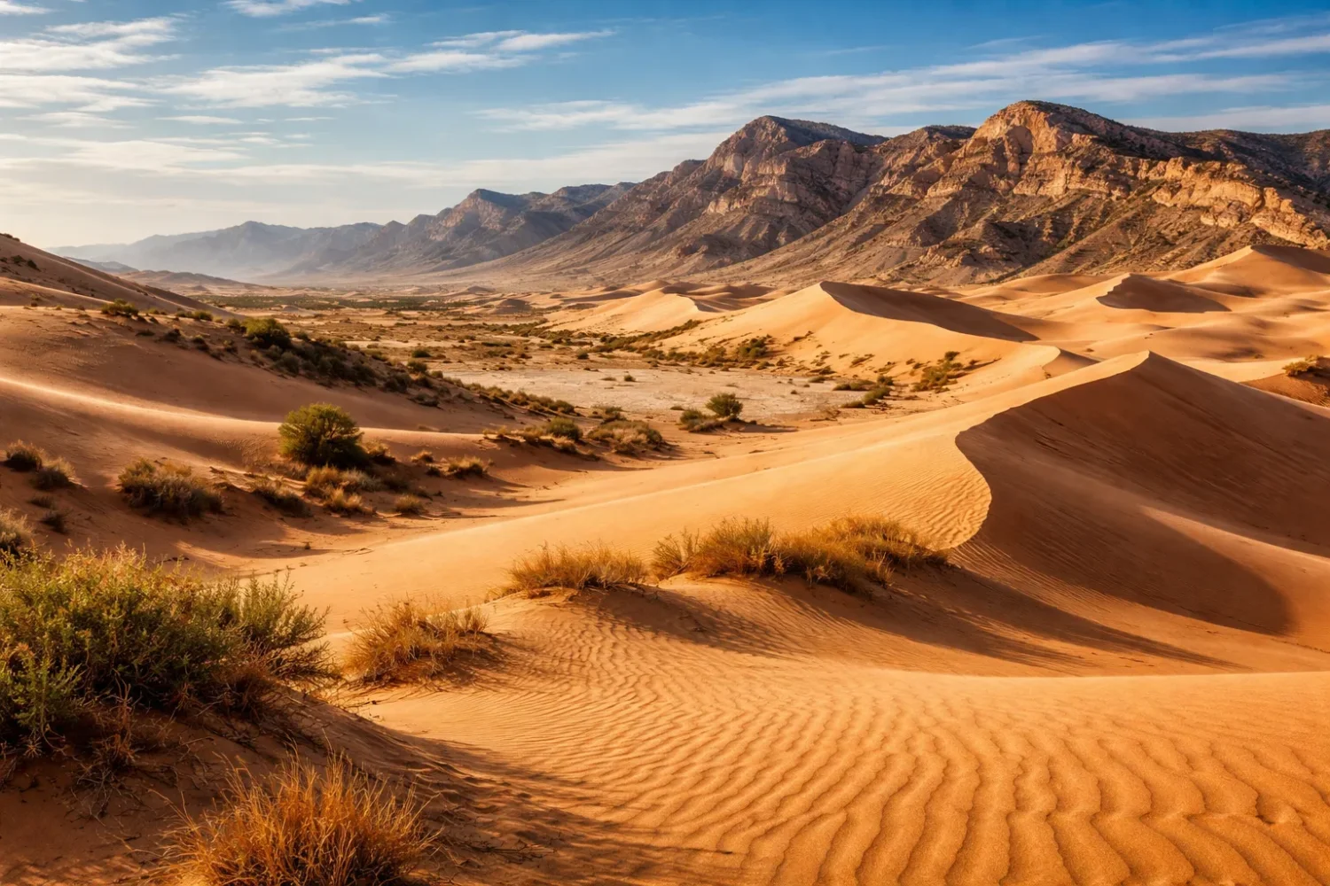
Oleshky Sands: Europe’s Sandy Semi-Desert in Ukraine
Oleshky Sands stands apart from the Spanish drylands because its identity is built around sand first. Located in southern Ukraine, inland from the Black Sea and near the lower Dnipro system, it is one of Europe’s best-known dune landscapes. NASA has described the frequently cited central sandy area as an oval-shaped region of about 161 square kilometers, the largest expanse of sand in Ukraine and one of the largest in Europe.
That number needs a little care. Different publications sometimes refer to the central dune field, while others describe a broader sandy massif that is much larger. So when area figures differ, it usually does not mean one source is wrong. It means authors are measuring different spatial units. That kind of clarification is often missing, and it matters.
The landscape itself is made of fine sand, low dunes, sparse vegetation, and wind-shaped relief. Dune heights are commonly given at around 5 meters in the well-known sandy core. That may sound modest compared with giant Saharan ergs, but scale is not the point here. The important fact is that a broad, active-looking, low-vegetation sand field exists in Europe under semi-arid conditions and creates a distinctly desert-like environment.
Oleshky Sands is usually described as a semi-desert rather than a classic hot desert. Its climate has a more continental cast than the Mediterranean arid zones of Spain. Winters are colder, seasonality is sharper, and the vegetation response differs. Yet the core desert signals remain clear: exposed sand, thin plant cover, localized sand movement, and a strong visual break from surrounding landscapes.
One of the most interesting parts of Oleshky is the contrast between the sandy interior and the forested belts planted around portions of the sands to limit dune spread. That edge condition gives the region a distinctive look. Inside the dune field, the land feels open and stripped back. At the margins, it becomes a managed interface between mobile sand and more stable ground. Simple on the surface, complex underneath.
Oleshky also broadens the idea of a European desert region beyond the Mediterranean. It shows that continental sandy semi-deserts belong in the same conversation as volcanic coasts and gypsum badlands. Dryness in Europe has more than one accent.
How These Five Regions Compare
| Region | Approximate Moisture Signal | Dominant Substrate | Main Landforms | Best Ecological Reading |
|---|---|---|---|---|
| Tabernas | Very low rainfall, strong summer dryness | Marls, clays, sandstones, alluvial sediments | Badlands, gullies, ramblas, fans | Hot dry scrub, arid ravine systems, desert-adapted flora |
| Bardenas Reales | Low and irregular rainfall, drying winds | Clay, chalk, sandstone, gypsum-bearing strata in places | Ravines, mesas, cabezos, plateaus | Semi-desert steppe, scrubland, bird-rich open terrain |
| Cabo de Gata-Níjar | Very low coastal rainfall, long dry season | Volcanic rocks, coastal deposits, saline flats | Domes, cliffs, lava-derived forms, dunes, fossil reefs | Sub-desert Mediterranean flora, saline habitats, dune and coastal communities |
| Monegros | Low rainfall but very high evapotranspiration | Gypsum-rich bedrock, saline soils, basin sediments | Plains, shallow depressions, saladas, low relief drylands | Steppe scrub, halophytes, saline wetland mosaics |
| Oleshky Sands | Continental semi-arid dryness | Fine sand | Low dunes, sandy ridges, open sand sheets | Sandy steppe and sparse dune vegetation |
Landforms That Define Europe’s Desert Regions
The five landscapes above belong together because they share the logic of water stress plus exposure. Yet they do not share one single shape. Understanding the landforms helps separate them clearly.
Badlands
Badlands appear where soft materials erode fast under sparse vegetation and irregular runoff. Tabernas and Bardenas Reales are Europe’s strongest examples in this set. The key signs are bare slopes, dense gully networks, sharp small-scale relief, and a surface that changes quickly after intense rain. In these places, the land almost looks unfinished. That is exactly the point.
Dune Fields
Oleshky Sands represents the dune-field model: wind sorts and redistributes loose sand, building ridges and low mobile forms. Sand alone does not define a desert, but where plant cover is thin and the atmosphere remains dry enough, dunes become the visible script of aridity.
Volcanic Sub-Desert Relief
Cabo de Gata-Níjar adds a third model. Here the dryland signal rides on volcanic and coastal relief: domes, cliffs, dykes, fossilized marine structures, and low-rain Mediterranean scrub. The result is not a basin badland and not a dune erg. It is a volcanic arid coast. Rare in Europe, and instantly readable once you know what to look for.
Saline Basin Drylands
Monegros is the saline-basin model. Endorheic depressions hold water briefly, then lose it by evaporation, leaving salts near or at the surface. Over time this produces playa-like wetlands, crusts, halophytic vegetation, and soil chemistry that shapes everything from plant cover to agricultural limits. Quiet landform, strong process.
Climate Patterns Behind European Aridity
A desert region is not just “a place with little rain.” In these European examples, rain timing, runoff style, evaporation pressure, and seasonal temperature range matter as much as the yearly total.
Tabernas depends on a hard moisture deficit, high solar exposure, and the shielding effect of surrounding relief. Bardenas relies on low rainfall plus strong erosion under open terrain. Cabo de Gata-Níjar mixes low rain with marine exposure and volcanic ground. Monegros shows that a place with more rainfall than Tabernas can still behave like a dryland because evaporation demand is so high and salts concentrate in closed basins. Oleshky proves that a sandy semi-desert can emerge in a more continental setting, where seasonality is sharper and the dune field becomes the main visual clue.
This is why using rainfall alone can mislead. Two regions may receive similar annual totals and still look nothing alike. Soil texture, infiltration, wind exposure, storage capacity, salinity, and topographic shelter all decide how far water actually goes. Desert climate is about effective dryness, not just rain on paper.
Technical Data Table
| Region | Approximate Area Figure Often Cited | Typical Annual Rainfall Figure | Other Useful Technical Note |
|---|---|---|---|
| Tabernas Desert | About 280 km² | Often below 250 mm | Average annual temperature above 17°C; strong badland erosion |
| Bardenas Reales | Roughly 39,000–42,500 ha depending on designation line used | Low, scarce, and irregular rather than one single uniform figure | Three major sectors: Bardena Blanca, Bardena Negra, El Plano |
| Cabo de Gata-Níjar Natural Park | About 49,512 ha in the biosphere reserve framing | Roughly 150–160 mm in the driest coastal points often cited | Volcanic complex formed about 13–14 million years ago |
| Monegros Desert | Broad regional landscape rather than one neat compact desert polygon | About 346 mm in well-studied core dryland sectors | Reference evapotranspiration around 1,255 mm; about 149 saline wetlands |
| Oleshky Sands | About 161 km² for the often-cited central sandy core | Low continental semi-arid totals, with area estimates varying by subzone | Dunes commonly cited around 5 m high in the central sandy field |
Area figures for some European drylands vary because writers may refer to a protected area boundary, a biosphere reserve boundary, a local core zone, or the wider physical landscape. That is normal in dryland geography and worth keeping in mind.
Plants, Soils, and Water Stress Across Europe’s Drylands
The easiest way to understand these regions is to look downward. Soils tell the truth of aridity. In Tabernas, thin cover and highly erodible sediments help create badlands. In Bardenas, soft materials and open exposure allow runoff to carve the land into ravines and isolated forms. In Cabo de Gata-Níjar, volcanic substrate and coastal salinity influence what can grow and where. In Monegros, gypsum and salt dominate the ecological script. In Oleshky, sand texture and moisture loss set the terms.
Plant life responds with the usual dryland tools: small leaves, waxy surfaces, deep or opportunistic roots, salt tolerance, seasonal dormancy, and patchy spacing. Bare ground is not always a sign of lifelessness; sometimes it is a sign of severe selectivity. Only certain species can handle the substrate, the drought cycle, and the heat load.
Water in these places behaves differently from water in humid Europe. It often arrives in brief pulses, runs off quickly, infiltrates unevenly, or evaporates before it becomes broadly useful. In Monegros, it may collect in closed saline hollows and vanish into the air, leaving minerals behind. In Tabernas and Bardenas, it cuts the ground while doing little to build continuous vegetative cover. In Cabo de Gata-Níjar, it works in short bursts through a coastal and volcanic terrain where every hollow, fan, and dune responds in its own way.
Rare are the European landscapes where soil chemistry and surface form are so tightly linked. These desert regions are among them.
Why Spain Dominates the European Desert Story
Four of the five regions on this page lie in Spain, and that is not an accident. Spain brings together several of the ingredients drylands need: Mediterranean summer drought, basin interiors, mountain rain shadows, high solar input, saline depressions, and stretches of very low rainfall in the southeast. Add varied geology and long erosional history, and you get a country with a whole spectrum of arid landscapes rather than just one famous desert.
Southeastern Spain, especially Almería, is the clearest case because it contains both Tabernas and Cabo de Gata-Níjar, two very different dryland expressions in close regional proximity. One is an inland badland desert basin. The other is a volcanic coastal sub-desert. Farther north, Bardenas Reales and Monegros show the Ebro Basin style of aridity: more steppe-toned, more saline in places, and more shaped by basin processes than by the dramatic desert pocket of Almería.
Spain also preserves many of these landscapes within strong protected-area frameworks. Biosphere reserve status, geopark recognition, and regional natural park systems have helped make them visible not only as scenic landforms, but as ecological and geological reference zones. That visibility matters for anyone trying to understand European deserts beyond a simple list.
Protected Status and Why It Matters
A striking thing about European desert regions is how often they sit inside protected or specially managed landscapes. That is partly because they are visually unusual, but more importantly because drylands often hold fragile soils, slow-recovering vegetation, saline systems, or rare habitat types that do not bounce back quickly after disturbance.
Bardenas Reales is a UNESCO Biosphere Reserve and Natural Park. Cabo de Gata-Níjar carries biosphere reserve recognition and UNESCO Global Geopark status. Tabernas is protected as a natural area and has high value for arid-land ecology and geomorphology. Monegros includes protected saline wetland and steppe sectors, even though the wider region also intersects with working agricultural land. Oleshky Sands has also been represented through protected-area frameworks in Ukraine.
Protection is not just a label. In drylands, one damaged slope, one altered drainage line, one disturbed crust, or one salinity shift can change the whole balance. Recovery tends to be slow because plant cover is already thin and soil formation is not fast. A humid meadow may green up again after impact. A dry gully wall or saline depression may not. Different rules apply here.
Human Presence in Europe’s Desert Regions
European deserts are not empty historical blanks. They have long been shaped by grazing, dry farming, water management, tracks, settlement edges, quarrying, conservation policy, and, in some places, cinema and scientific research. The cultural layer is part of the geography.
In Tabernas, film production turned dry valleys and badlands into one of Europe’s best-known visual deserts. That legacy still colors how the place is imagined. In Monegros, agriculture and irrigation history are impossible to ignore because they sit so close to fragile saline systems. In Bardenas Reales, land use and open-country ecology have long overlapped. In Cabo de Gata-Níjar, the dry coast carries fishing heritage, salt-related history, rural settlement traces, and the imprint of protected-land management.
None of that makes these regions less desert-like. It makes them more European. The desert story here is not one of total emptiness, but of human use at the edge of ecological limits. That edge is the interesting part.
Common Misunderstandings About Deserts in Europe
“Europe Has No Real Deserts”
That statement is too broad. Europe has very few true desert-climate areas, but it does have them, and it certainly has multiple semi-desert and desert-like regions. Tabernas is the clearest mainland example. The others show different grades of aridity.
“A Desert Must Be Covered in Sand”
Not at all. Badlands, saline flats, rocky plateaus, gypsum steppes, and volcanic drylands can all belong in desert geography. Bardenas and Tabernas make that plain at a glance.
“If Rainfall Is Higher Than the Sahara, It Is Not a Desert”
That comparison misses the point. Desert classification depends on regional climate balance, evaporation pressure, vegetation response, and soil-water relations, not on a race to be drier than the Sahara.
“These Places Are Just Tourist Labels”
Some places are oversold, yes. These five are not empty labels. Each has a real arid-land basis in climate, geomorphology, soil, or vegetation. The scientific language around them may differ, but the dryland signal is real.
Which Region Is the Best Example of a European Desert?
If the question is “Which one most clearly fits a true desert-climate reading on mainland Europe?” the answer is Tabernas Desert.
If the question is “Which one shows the boldest badland scenery?” many readers will choose Bardenas Reales.
If the question is “Which one adds the most unusual geology?” it is hard to beat Cabo de Gata-Níjar.
If the question is “Which one best explains saline dryland ecology?” Monegros stands out.
If the question is “Which one shows Europe’s sandy semi-desert face?” the answer is Oleshky Sands.
How to Read Europe’s Deserts as One Story
Put side by side, these regions form a neat sequence of European aridity types.
- Tabernas shows the desert-climate core.
- Bardenas Reales shows erosion-led semi-desert relief.
- Cabo de Gata-Níjar shows coastal volcanic sub-desert geography.
- Monegros shows saline steppe and water-balance stress.
- Oleshky Sands shows dune-field semi-desert under continental conditions.
That is why these places belong on the same pillar page. Not because they are identical, but because each answers a different part of the same question: what does desert geography look like when it appears inside Europe?
The answer is not one clean postcard. It is badlands, salt pans, gypsum plains, volcanic cliffs, dune belts, ravines, fan palms, halophytes, steppe scrub, and land cut by water that rarely stays long. It is a continent better known for rivers and forests still carrying pockets of dryness sharp enough to build their own landscapes.
Small, yes. But forgettable? Not even close.