
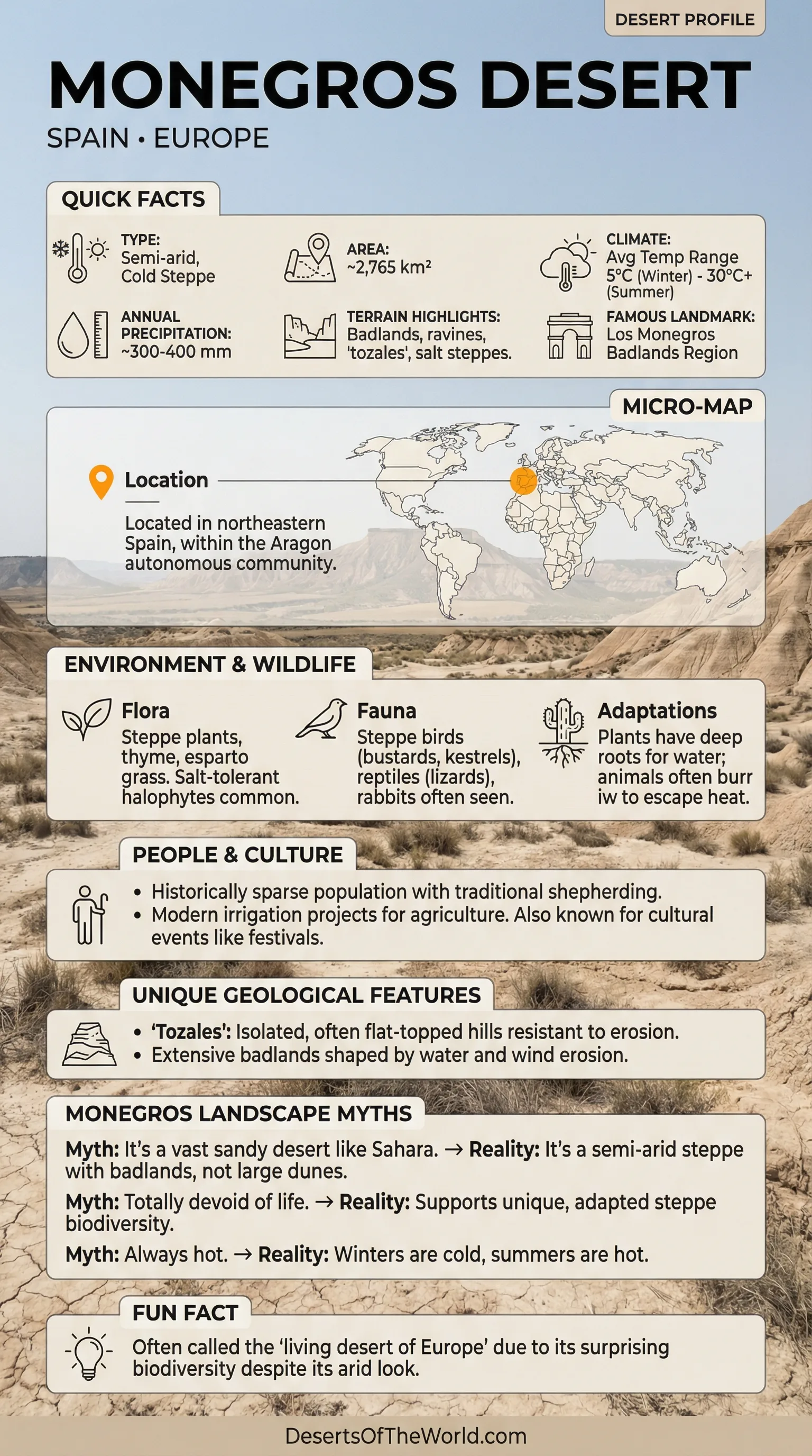
Location & Continent
Continent: Europe
Country: Spain
Region: Aragón, within the Ebro Depression; the Los Monegros landscape extends across parts of Huesca and Zaragoza provinces
Coordinates: 41°30′N, 0°15′W
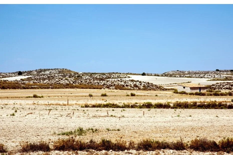
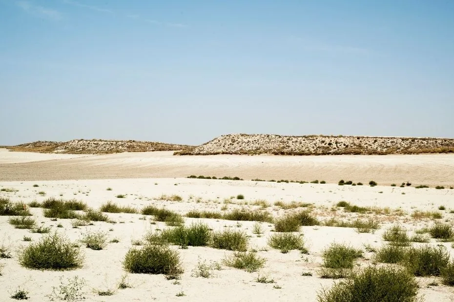
Photos of the Monegros Desert
Physical Features
Area: More than 275,000 hectares (~2,750 km²) in the wider Los Monegros landscape
Landscape: Semi-arid plains, gypsum steppe, cereal fields, saline depressions, eroded hills and ravines
Elevation: Low plains are generally a few hundred meters above sea level; the Sierra de Alcubierre rises to 834 m at San Caprasio
Climate & Precipitation
Temperature: Hot summers that can approach 40°C; cold winters with temperatures below 0°C during some periods
Precipitation: Generally about 300–400 mm annually, irregular and concentrated mainly in spring and autumn; some years remain below 200 mm
Ecological Features
Ecozone: Palearctic
Environment: Semi-arid Mediterranean steppe, gypsum scrub, cereal plains and saline endorheic habitats
Protected Habitats: Several Natura 2000 sites protect steppe birds, gypsum vegetation, saline depressions and parts of the Sierra de Alcubierre
Flora & Fauna
Flora: Gypsum- and salt-tolerant vegetation, thyme, rosemary, albardín grass, tamarisk, juniper and localized woodland on higher ground
Fauna: Dupont’s lark, little bustard, great bustard, lesser kestrel, stone-curlew, pin-tailed and black-bellied sandgrouse, raptors, reptiles and specialized invertebrates
Geology & Notable Features
Geology: Sedimentary terrain of the Ebro Depression dominated by gypsum, clay, marl and limestone, with erosion producing ravines, isolated hills and badland-like forms
Notable Features: Sierra de Alcubierre, Jubierre erosional formations, gypsum steppe, saline depressions and broad dry cereal plains
Monegros Desert Festival
Overview: The Monegros Desert Festival is an electronic music event held near Fraga in Huesca province, within the wider Los Monegros landscape.
Founded: 1994
Genre: Electronic music, including techno, house and related styles, with additional stages covering other genres
Current Format: A non-stop event lasting about 22 hours
Monegros Desert Festival 2027
The official festival website has moved into its “Road to the desert 2027” phase. Early Bird tickets are listed as sold out.
The official Artists 2027 and Stages 2027 pages are still marked as coming soon. No confirmed 2027 festival date or full artist lineup is currently published on those pages, so those details should not be inferred from previous editions.
2026 Edition: Held from 2:00 p.m. on July 25 to 12:00 p.m. on July 26, 2026
Introduction
The Monegros Desert is a semi-arid landscape in Aragón, northeastern Spain, within the central Ebro Depression. The name “desert” reflects its dry appearance, sparse steppe vegetation and long periods with limited rainfall, although its climate is more accurately described as semi-arid Mediterranean with strong continental influence. Gypsum soils, saline depressions, cereal plains and the Sierra de Alcubierre create several distinct environments within the region.
Geography
The wider Los Monegros landscape covers more than 275,000 hectares in central Aragón. Much of the terrain belongs to the Ebro Depression and consists of broad plains interrupted by low hills, ravines, saline basins and the long ridge of the Sierra de Alcubierre.
The Sierra de Alcubierre extends for more than 60 km and divides much of the dry landscape from west to east. Its highest point, San Caprasio, reaches 834 m, while nearby Monte Oscuro reaches 812 m. These higher areas support more woodland than the surrounding gypsum steppe and cereal plains.
Landforms and Soil
Gypsum, clay, marl and limestone are widespread in Los Monegros. Because many of these materials erode easily, runoff has cut networks of gullies and ravines into slopes and exposed sedimentary surfaces.
The Jubierre area is one of the clearest examples. Erosion has produced isolated hills, narrow ridges, steep-sided gullies and sculpted formations such as the Tozal de la Cobeta and Tozal Solitario. Elsewhere, flat gypsum surfaces and saline depressions support plant communities adapted to mineral-rich soils.
Water and Irrigation
Natural surface water is limited and irregular across much of Los Monegros. Some depressions are endorheic, meaning water has no external river outlet, and temporary saline lagoons can form where runoff and groundwater collect.
Agriculture has also been reshaped by large irrigation systems. The Canal de Monegros carries water derived from the Gállego system, while the Canal del Cinca and associated Riegos del Alto Aragón network supply other irrigated sectors. This creates a clear contrast between unirrigated steppe and intensively cultivated areas.
Climate
Los Monegros has a semi-arid Mediterranean climate with continental characteristics. Aragón government planning documents place average annual precipitation broadly around 300–400 mm, although some years receive less than 200 mm.
Rainfall is irregular and falls mainly in spring and autumn. Summers are dry and hot, while winters can be cold and frosty. Strong evaporation and unreliable rainfall contribute to dry soils and limit natural vegetation on exposed plains.
Temperature Extremes
Summer temperatures can approach 40°C (104°F) during hot spells. Winter conditions are very different: temperatures may fall below freezing, particularly on clear nights and at higher elevations.
This seasonal range separates Los Monegros from warm coastal Mediterranean environments and helps produce a mixture of Mediterranean, steppe and continental ecological conditions.
Biodiversity
The dry plains, gypsum outcrops, saline depressions, cereal fields and higher woodland areas support different plant and animal communities. Several parts of Los Monegros are included in the Natura 2000 network because of their steppe birds, gypsum vegetation, saline habitats and other dryland features.
Some saline areas contain specialized plants such as Halopeplis amplexicaulis and Microcnemum coralloides. Gypsum soils also support plant communities adapted to high mineral content and limited moisture.
Flora
- Gypsum and Steppe Vegetation: Low shrubs, thyme, rosemary and dry grasslands occur across exposed terrain.
- Saline Vegetation: Salt-tolerant plants occur around endorheic depressions and temporary saline lagoons.
- Woodland: Juniper, pine, holm oak and other woody vegetation are more evident in parts of the Sierra de Alcubierre and on less exposed slopes.
- Agricultural Mosaic: Dry cereal fields and fallow land now form an important part of the steppe landscape used by several bird species.
Fauna
Open plains and cereal-steppe habitats support several birds associated with dry Iberian landscapes. These include the Dupont’s lark, little bustard, great bustard, lesser kestrel, stone-curlew, black-bellied sandgrouse and pin-tailed sandgrouse.
Raptors use both open country and the Sierra de Alcubierre. The region also supports reptiles and a notable invertebrate fauna, including species associated with saline and gypsum habitats. Wildlife distribution varies considerably between dry plains, cultivated land, wetlands and wooded uplands.
Land Use and Cultural Landscape
Agriculture and livestock raising have shaped Los Monegros for centuries. Dry cereal farming remains widespread, while irrigation has transformed other areas into more intensive agricultural land.
Villages, wells, livestock routes, agricultural buildings and irrigation works form part of the present landscape. The Sierra de Alcubierre also contains sites connected with the Spanish Civil War, including restored trenches along routes associated with George Orwell’s time on the Aragón front.
Local Communities
Settlements across Los Monegros are generally small and closely connected with agriculture and livestock production. Traditional dryland farming continues alongside irrigated agriculture, sheep farming and modern rural industries.
The contrast between dry steppe, cultivated plains and irrigated fields is therefore partly natural and partly the result of long-term changes in water management and land use.
Tourism
Visitors can explore Los Monegros by marked walking, cycling and driving routes. The Jubierre formations, Sierra de Alcubierre, Civil War sites and steppe-bird habitats are among the main points of interest.
Birdwatching is especially relevant in areas protected for steppe species. Routes should remain on established tracks where required, particularly around sensitive habitats and during periods when ground-nesting birds are breeding.
Key Features of Monegros Desert
| Feature | Description |
|---|---|
| Area | More than 275,000 hectares (~2,750 km²) |
| Climate | Semi-arid Mediterranean with continental influence |
| Annual Rainfall | Generally 300–400 mm, with strong year-to-year variation |
| Highest Local Relief | San Caprasio, 834 m in the Sierra de Alcubierre |
| Notable Wildlife | Dupont’s lark, little bustard, great bustard, lesser kestrel and sandgrouse |
References
Spain.info – Los Monegros Desert
Government of Aragón – Sierra de Alcubierre y Sigena
Government of Aragón – Los Monegros Environmental and Climate Profile
Atlas of Aragón – Irrigation in Los Monegros
Los Monegros Tourism – Landscape, Routes and Local Geography
Monegros Desert Festival – Road to the Desert 2027
Monegros Desert Festival – 2027 Tickets