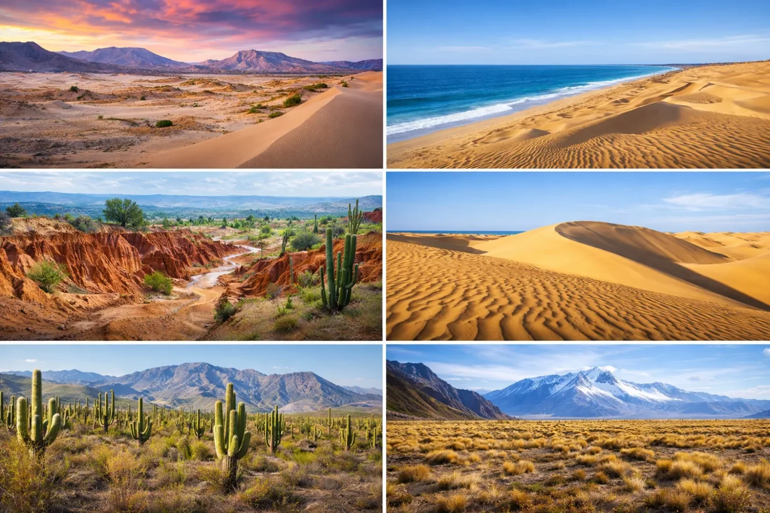
South America does not have one desert story. It has six very different dryland stories, each shaped by a different mix of ocean currents, mountain barriers, seasonal wind belts, local geology, and water scarcity. Put them side by side and the contrast is sharp: one desert can go years with almost no measurable rain, another gets flooded during El Niño, another is better described as a desert-like sand country than a true desert.
Jalapão Microregion
Location & Continent Continent: South America Country: Brazil State: Tocantins (eastern part of the state) Region: Semi-arid Jalapão...
Read More →Sechura Desert
Location & Continent Continent: South America Countries: Mainly Peru; parts of the broader ecoregion extend into coastal Ecuador...
Read More →Patagonian Desert
Location & Continent Continent: South America Countries: Mainly Argentina, with smaller steppe areas extending into Chilean Patagonia Region:...
Read More →Monte Desert
Location & Continent Continent: South America Country: Argentina Region: Eastern foothills of the Andes, from northern–central Argentina to...
Read More →La Guajira Desert
Location & Continent Continent: South America Countries: Mainly Colombia (La Guajira Department), with a smaller portion in Venezuela...
Read More →Atacama Desert
Photos of the Atacama Desert Location & Continent Continent: South America Countries: Mainly northern Chile; some broader definitions...
Read More →6 inventions in South America
That is why a single list of names never tells the full thing. The Atacama Desert is the dry benchmark most people know. The Sechura Desert sits on the same cold Pacific margin but behaves in a more erratic way. La Guajira Desert is a hot, windy coastal desert facing the Caribbean. The Monte Desert is a shrub desert on the eastern side of the Andes. The Patagonian Desert is a cold steppe desert built by rain shadow and relentless wind. Then there is Jalapão, where dunes and seasonal dryness create a desert image even though the wider region still belongs to the Cerrado domain and carries more water than a classic desert should.
Maps make the continent look tidy; on the ground, it is not that neat. Desert borders in South America often fade rather than stop. A dry coast turns into a fog-fed slope. A sand plain gives way to thorn scrub. A cold steppe melts into shrubland. Some limits change from one atlas to another, totaly normal for regions where climate, relief, and vegetation grade into each other instead of ending like a painted line.
This page brings the six landscapes together in one place, using the same lens for all of them: location, climate data, landforms, plants and animals, and the role each one plays inside the wider arid diagonal of South America. Read that way, patterns appear fast. Cold-current deserts cluster on the Pacific side. Rain-shadow deserts stretch east of the Andes. Desert-like sandy country appears inside Brazil for a very different reason.
How South America Builds Deserts
South America creates arid land with a small set of powerful climate engines. The first is the Humboldt Current, the cold Pacific flow that chills the air along Peru and Chile. Cold air holds less moisture than warm air. It also helps produce temperature inversions, where a cooler layer near the surface blocks rising air and weakens cloud growth. The result is familiar on the Pacific margin: fog, low cloud, and very little rain.
The second engine is the Andes. Those mountains work like a giant wall. Moist air from the Pacific or the Atlantic does not cross them evenly. On some flanks the Andes squeeze out moisture. On the lee side, dry conditions dominate. That matters in two opposite ways. West of the Andes, the coast can stay dry because the cold ocean and subtropical high pressure keep rain weak. East of the Andes, places like Patagonia and large parts of the Monte turn dry because the mountains strip moisture from westerly air before it reaches the steppe and basin country beyond.
A third engine sits farther north: the trade-wind belt. In La Guajira, strong winds, high evaporation, sparse river flow, and a hot coastal setting combine to make a desert on the Caribbean edge of the continent. There, dryness is not built by the Humboldt Current alone. It is built by heat, persistent wind, and very uneven seasonal rain.
Then there is the matter of time. Some South American deserts are ancient in geomorphic terms. The Atacama, for example, is often treated as one of the oldest non-polar deserts on Earth, with hyper-arid conditions established over very long spans. Others are dry, yes, but less locked in place. The Sechura can be transformed by strong El Niño years. Jalapão can look parched and sandy in the dry season, yet it is cut by rivers, springs, and wet veredas.
Cold Ocean Desert Pattern
Atacama and Sechura owe much of their dryness to the cold Pacific margin, stable air, and weak convective rainfall.
Rain-Shadow Desert Pattern
Monte and Patagonian drylands sit east of the Andes, where mountain blocking and strong winds control water supply.
Hot Coastal Desert Pattern
La Guajira is shaped by heat, trade winds, strong evaporation, and sparse, uneven rainfall on the Caribbean rim.
Desert-Like Sand Mosaic
Jalapão has dunes and stark dry-season scenery, yet it remains tied to the Cerrado, springs, and seasonal water.
What Counts as a Desert Here, and What Does Not
One of the weakest parts of many South America desert roundups is classification. They often throw every sandy or semi-arid place into the same bag. That makes the page longer, but not clearer. A climatological desert usually means very low rainfall and high aridity. A xeric shrubland may look desert-like without matching the same dryness. A steppe desert can support more plant cover than a bare dune field. A savanna with dunes can still be dry-season harsh without being a true rainless desert.
That matters especially for Jalapão. It belongs in this conversation because readers searching for South American deserts often expect to see it, and because its dunes are famous. Still, it does not behave like the Atacama or even like La Guajira. It has a strong wet season, many clear-water streams, spring-fed pools called fervedouros, and broad Cerrado vegetation around the sand fields. It is better treated as a desert-like microregion with striking dunes than as a textbook hyper-arid desert.
Sechura needs a similar caution, though for a different reason. Some maps use a small strict core, others use a much broader coastal belt. That is why the reported size of Sechura can vary wildly from one source to another. The place is real, of course. The boundary is what shifts. For readers, the smarter move is to focus on process: low rainfall, coastal aridity, dunes, dry plain, and periodic El Niño disruption.
South American Deserts Compared Side by Side
| Desert or Dryland | Main Country or Countries | Usual Type | Typical Rainfall Pattern | Landscape Signal | What Makes It Stand Out |
|---|---|---|---|---|---|
| Atacama Desert | Chile, with broader transition toward southern Peru | Cold coastal desert, hyper-arid core | Often under 15 mm a year in many parts; hyper-arid core can fall below 2 mm | Salt flats, volcanic plateaus, gravel plains, fog-fed slopes | One of the driest non-polar places on Earth |
| Sechura Desert | Peru, with broader coastal arid continuity toward Ecuador | Coastal desert | Often around 20 to 100 mm in low areas, with higher values on some margins | Dunes, depressions, dry plain, episodic flood zones | Can flip from extreme dryness to El Niño flooding |
| La Guajira Desert | Colombia and Venezuela | Hot coastal desert to semi-desert | Often below 300 mm in the driest far north, higher in some interior sectors | Coastal dunes, rocky headlands, salt flats, seasonal wadis | Desert beside the Caribbean, with a cloud-forest oasis at Macuira |
| Monte Desert | Argentina | Shrub desert and dry steppe | Roughly 80 to 450 mm depending on sector and elevation | Jarilla shrublands, alluvial fans, basins, salt flats | A desert of shrubs more than bare sand |
| Patagonian Desert | Argentina, with steppe extensions into Chilean Patagonia | Cold desert steppe | Often about 90 to 430 mm a year | Gravel plains, mesas, basalt plateaus, windy steppe | Largest desert in Argentina and among the largest cold deserts on Earth |
| Jalapão Microregion | Brazil | Desert-like sandscape within the Cerrado | Strong wet and dry season; far wetter annually than true deserts | Orange dunes, sandstone escarpments, springs, veredas | Looks desert-like, but water and seasonal ecology change the classification |
Seen together, these six places show why the phrase South American deserts is helpful only when it stays precise. The continent does not offer one repeating model. It offers a cold ocean desert, a flood-prone coastal desert, a hot trade-wind desert, a shrub desert, a cold steppe desert, and a desert-looking savanna sand country. Same continent. Very different drylands.
Atacama Desert
The Atacama Desert sits in northern Chile and stretches for roughly 1,000 to 1,100 kilometers along the Pacific side. Depending on the boundary used, the desert is often placed at around 105,000 square kilometers for its core Chilean extent, while broader regional definitions can push the number higher. That variation does not weaken the point. The Atacama is the driest benchmark in South America and, for many readers, the driest benchmark anywhere outside the polar deserts.
Why the Atacama Is So Dry
Three controls work together here. First, the Humboldt Current cools the lower atmosphere along the coast. Second, the subtropical high-pressure belt favors descending air rather than rising, rain-making air. Third, the Andes help cut off moisture from the east. That combination is brutally effective. In many parts of the desert, average annual rainfall is around 15 millimeters or less. In the hyper-arid core, some studies place annual precipitation below 2 millimeters.
The image most people carry is simple: no rain, no life. The real Atacama is stranger than that. It has fog, not just sun. It has salars, not just dunes. It has high volcanic basins where flamingos feed, and lower barren plains where salt and nitrate dominate the surface. It can look dead from a distance, then reveal pockets of adapted life when you slow down.
Technical Snapshot for the Atacama
- North-south length often given as 1,000 to 1,100 km
- Many sectors receive around 15 mm of rain a year or less
- Hyper-arid core can fall below 2 mm annually
- ALMA observatory operates on the Chajnantor Plateau at roughly 5,000 m altitude with 66 antennas
Landforms, Elevation, and Surface Detail
The Atacama is not one endless sand sheet. Much of it is a stone, salt, and sediment desert. Gravel plains, alluvial fans, salar basins, lava surfaces, badlands, and dry channels often matter more than mobile dunes. The Pacific margin has coastal ranges and fog-prone slopes. Inland, the terrain rises toward high plateaus and volcanoes. Some sectors are low and stark. Others are high enough to feel alpine in the air, even while staying desert-dry.
That vertical range explains why the Atacama keeps surprising people. A lowland visitor may think only of bare ground and salt crust. A high Andean basin reveals lagoons, puna grass, and a different suite of birds and mammals. Same desert, very different ecological zones. Rarely does a South American desert show altitude so clearly in its scenery.
Fog, Salars, and Life at the Limit
One of the most interesting Atacama patterns is the role of fog. Along some coastal slopes, fog moisture can sustain specialized plant communities called lomas. These are not lush forests. They are thin, local, fragile green pulses where the atmosphere gives life without offering proper rain. That matters because it shows a classic desert lesson: water does not need to arrive as a downpour to reshape ecology.
In the interior, salars become another defining feature. Closed basins trap dissolved minerals. Evaporation does the rest. Over time, salts accumulate and turn the ground into bright crusts, shallow brines, and polygonal surfaces. On the higher salar systems, flamingos feed in mineral-rich lagoons. Around them, the land can look almost extraterrestrial. That word gets overused. Here, it fits.
Plants, Animals, and Adaptation
At the harshest sites, plant cover is extremely low. Yet the desert is not empty. In moister micro-sites or along elevation gradients, you find tamarugo, cushion plants, salt-tolerant shrubs, and high-altitude grasses. Animal life includes vicuñas, flamingos, foxes, lizards, and a long list of hardy invertebrates and microbes. Microbial life in Atacama soils has drawn global scientific attention because the desert offers one of the best natural laboratories for studying survival under severe dryness.
Another Atacama surprise is the occasional desert bloom. When unusual rain arrives in the right season, dormant seeds can germinate and cover parts of the desert with flowers. It does not happen every year, and it does not happen everywhere. That is exactly why it matters. In the driest systems, the rare event can carry enormous ecological weight.
Why the Atacama Matters Beyond Its Own Borders
The Atacama is central to any South America desert comparison because it acts like the dry end-member of the continent. If you want to understand how dry the Sechura is, you compare it to the Atacama. If you want to explain why Jalapão is not a true desert, the Atacama is the reference. If you want to show the difference between a hyper-arid core and a seasonal dryland, again, the Atacama makes the contrast obvious.
It also carries technical weight outside geography. Astronomy depends on it. The desert’s high elevation, low humidity, and exceptionally clear skies are why facilities like ALMA operate there. A place known for almost no rainfall ends up helping humans study the early universe. South America does that sort of contrast very well.
Sechura Desert
The Sechura Desert runs along the northern Pacific side of Peru, mainly across parts of Piura and Lambayeque. Some descriptions use a narrow core around the Sechura plain. Others stretch the label across a much broader coastal ecoregion. That is why one source may describe a modest desert unit while another quotes an area close to 50,000 square kilometers. Both are talking about the same dry system from different map scales.
A Coastal Desert With a Mood Swing
Like the Atacama, Sechura sits under the influence of the cold Pacific current. The ocean cools the lower atmosphere and keeps rainfall weak across much of the coast. In low areas, annual precipitation can fall in the range of 20 to 100 millimeters, with somewhat higher values on margins and raised ground. Yet Sechura does not lock into hyper-aridity as tightly as the Atacama does. That is its defining twist.
When strong El Niño events arrive, the desert can change fast. Water that seems absent most years can spread across flats and basins. During extreme episodes, large temporary water bodies may form in the Sechura system. That is not a side note. It is one of the clearest examples in South America of a desert whose character depends on climate variability as much as on average dryness.
Atacama and Sechura Are Not the Same Kind of Dry
- Atacama: steadier, deeper dryness; hyper-arid core
- Sechura: dry coastal setting, but much more sensitive to El Niño pulses
- Shared trait: both are tied to the cold Pacific margin
- Big difference: Sechura can swing harder between drought and flood
Relief, Dunes, and the Shape of the Plain
Sechura is often imagined as one simple dune field. In reality, it mixes sand sheets, dunes, flat arid plains, shallow depressions, dry channels, and coastal sectors that link desert ground with marine influence. Wind activity moves sand, but the desert also records the work of river floods and periodic water accumulation. It is less like a static postcard and more like a surface in negotiation with climate.
The Sechura Depression adds another layer to the desert’s identity. Low-lying terrain matters in dry countries because it controls drainage, salt accumulation, and flood behavior. In wet years, topographic lows do not stay abstract lines on a map. They become hydrologic events.
Why Sechura Is Ecologically More Mixed Than It Looks
Many pages reduce Sechura to “empty coastal sand.” That misses too much. Around the wider desert and ecoregional transitions, you find links to dry forest, scrub, ephemeral herbs after rain, and saline or marsh-like environments in specific low sites. Some plant life waits for moisture pulses. Some persists in scattered form through long dry phases. The result is a desert that can look bare for a long time and still support a richer ecological rhythm than outsiders expect.
This is where Sechura differs sharply from the idea of a desert as a place with one fixed face. In average years it reads as austere. After unusual rain, it can flip into a biologically active surface. Seeds germinate. Surface water appears. Insects respond. Birds respond after them. Then the cycle contracts again. Briefly alive, then spare again.
Climate Data That Actually Helps
Readers usually want one clean number, but Sechura works better as a range. In its driest low sectors, annual precipitation may sit around 20 to 50 mm. Elsewhere, especially on slightly higher or more interior margins, it may climb toward 100 to 200 mm. That spread matters because it explains the mixed vegetation and the unstable desert boundary. Temperature also stays moderated by the nearby Pacific more than many inland deserts do.
So what is Sechura, exactly? It is a coastal desert system with sandy surfaces, low rainfall, and strong sensitivity to ocean-atmosphere anomalies. That last part is the detail many pages leave too soft. They should not. It is the piece that makes Sechura memorable.
Why Sechura Belongs Near the Top of the South America List
Sechura belongs in any serious South American desert page because it helps explain the whole Pacific dry corridor. It shows what happens when cold-current aridity meets a climate system that can still deliver periodic shocks. Put bluntly, Sechura teaches readers not to confuse dry on average with always dry in the same way.
It also helps correct a common ranking mistake. The continent’s most famous desert is not automatically the best example of all the others. If the Atacama shows dryness at its extreme limit, the Sechura shows variability inside aridity. That makes it just as useful for understanding South America’s desert map.
La Guajira Desert
The La Guajira Desert occupies the northernmost tip of South America, mainly in Colombia with a smaller extension into Venezuela. It faces the Caribbean, not the Pacific. That single fact changes the whole desert mood. The air is hotter, the light harsher, the wind more constant, and the relation between coast and desert feels immediate. In places, dunes seem to run straight toward the sea.
Hot, Windy, and Dry for Different Reasons
La Guajira is usually described as arid to semi-arid. In the driest northern sectors, annual rainfall often stays below 300 mm, while other parts of the peninsula receive more. Some agroclimatic work for Uribia, for example, places local annual rainfall in the 300 to 600 mm band, paired with very high evapotranspiration around 2,000 mm. That imbalance tells the real story better than rainfall alone. Even where some rain arrives, the atmosphere can take water back fast.
Trade winds are a big part of the equation. They help keep the landscape open, dry, and mobile. Sand moves. Salt pans function. Coastal evaporation stays high. In prime wind zones, energy studies often highlight average wind speeds strong enough to make La Guajira stand out within the Colombian Caribbean. You can feel that desert logic even without a graph. The wind is not background here. It is one of the authors of the landscape.
A Desert by the Caribbean, Not by the Pacific
This is one of the best reasons to include La Guajira on a pillar page. It breaks the lazy assumption that South American deserts are mainly a Pacific-side story. La Guajira proves otherwise. You can have a desert on the Caribbean edge, built not by the Humboldt Current but by heat, wind, scarce surface water, and a long dry season.
The scenery reflects that difference. Coastal dunes, low rocky headlands, salt flats, seasonal drainage lines, and open thorn scrub make up much of the region. The colors are often pale gold, rusty brown, white salt, and Caribbean blue. It is a hard landscape, yes, but not monotonous. Look closer and the texture changes from beach-dune systems to scrub plains to rocky sectors very quickly.
The Macuira Contrast
La Guajira also contains one of the most striking internal contrasts of any South American desert: Macuira. The Macuira massif rises as an oasis-like mountain block inside the semi-desert of Alta Guajira. Moisture from the atmosphere can condense there and support pockets of greener vegetation, including cloud-forest conditions on the heights. In plain language, a desert landscape can hold a mountain refuge that feels like a different biome entirely.
This matters for readers because it stops the region from being flattened into a stereotype. La Guajira is dry, but not simple. It has microclimates. It has local relief effects. It has ecological pockets that only make sense when you track wind, elevation, and coastal moisture together.
Vegetation, Wildlife, and Human Geography
Plant cover in La Guajira usually appears as xerophytic scrub, thorny bushes, cacti, sparse grasses, and salt-tolerant vegetation in select areas. Trees are limited and tied to water availability. The visual result is open land with long sightlines, where vegetation clusters rather than blankets. Animal life includes birds of dry coast and scrub, reptiles, goats in pastoral landscapes, and species adapted to heat and water scarcity.
The human geography is just as important to understanding the desert, though it should be handled with care and respect. The region is strongly associated with the Wayuu people, whose presence is not a decorative detail but part of the place itself. A desert page does not need to turn cultural life into a side attraction. Better to say the clear thing: La Guajira is a dryland with lived landscapes, not an empty stage.
Why La Guajira Feels Different From the Other Five
La Guajira stands apart because it is the hottest coastal desert mood in this list. The Atacama is colder in feel and tied to altitude and salt basins. Patagonia is colder and wind-scoured. Monte is shrubbier. Sechura is more flood-sensitive. Jalapão is not a true desert in climate terms. La Guajira, by contrast, reads as sun, wind, salt, and drought right away.
If you want a clean mental tag for it, use this one: the Caribbean desert of South America. That is simple, accurate, and sticky enough to remember.
Monte Desert
The Monte Desert stretches across much of western and north-central Argentina, mainly along the eastern foothills of the Andes and adjoining basins. It is often split into Low Monte and High Monte. Taken together as a biome, the Monte covers roughly 460,000 to 470,000 square kilometers, with the Low Monte alone around 354,000 square kilometers and the High Monte close to 117,000 square kilometers.
A Desert of Shrubs, Not an Ocean of Sand
This is one of the most misunderstood drylands in South America. Many readers expect a desert to mean bare sand and tall dunes. The Monte does not play that role. It is mostly a shrub desert, marked by jarilla scrub, scattered grasses, cacti, and hardy woody plants that can handle dry soils, high evaporation, and large temperature swings. Some areas include alluvial fans, gravelly surfaces, badlands, or salt flats, but the core visual identity is shrubland.
That difference is not cosmetic. It changes everything from wildlife cover to soil behavior to how people use the land. A shrub desert holds more surface structure than a bare dune field. Wind acts differently. Water infiltration acts differently. Animal shelter works differently. So does grazing pressure.
Climate and Seasonal Pattern
The Monte is arid to semi-arid, with rainfall varying strongly by sector. Broadly, the numbers run from under 100 mm in the driest pockets to around 450 mm in less arid sectors, while the Low Monte is often placed in the 80 to 250 mm band. In much of the north and center, most rain falls during the austral summer. Farther south, seasonality becomes less tidy and the climate feels cooler, windier, and harsher.
The Monte belongs to the great arid diagonal of South America, the dry belt that runs from the northwest toward Patagonia. Its dryness is tied to relief, continentality, and the shadow effects produced by mountain systems. It does not need an ocean-current story as strong as the Pacific deserts do. The mountain-and-basin setting already does plenty of work.
| Monte Trait | What It Means on the Ground |
|---|---|
| Jarilla dominance | The desert often looks like shrub steppe rather than open sand |
| Alluvial basins | Water and sediment move from mountain fronts into plains and closed depressions |
| Low rainfall range | Plant spacing stays open and water stress shapes most ecological processes |
| Biome transitions | The Monte links with Chaco, Puna, and Patagonian environments rather than standing alone as a simple block |
Relief, Soils, and Dryland Structure
Relief in the Monte can look subdued from a satellite image, but it is not boring. Piedmont zones, dry valleys, basin floors, saline depressions, and old alluvial surfaces create strong environmental gradients. In arid Argentina, small changes in topography matter a lot because they control where runoff gathers, where salts accumulate, and where deeper-rooted shrubs can survive. A site with slightly better drainage may support one plant community. A flatter saline floor may support another. That is desert structure in plain sight.
The soil story follows the same rule. Aridity favors sparse organic matter, patchy crust development, salinization in low basins, and large areas where the surface can be fragile under heavy disturbance. The Monte does not need sand seas to be a desert. Water deficit does enough work by itself.
Plants, Endemism, and the Monte Identity
If one plant group defines the Monte visually, it is Larrea, the jarilla shrubs. Around them come cacti, thorny scrub, Prosopis woodland in better-watered spots, and grasses adapted to dry conditions. Some biogeographic work has also shown that the Monte holds notable local endemism in plants and insects. That is one more reason it should not be treated like a filler desert on a continent list.
The Monte also teaches a useful lesson about desert perception. A greener desert is still a desert. A place with shrubs is not automatically “less dry” in any practical sense. Sometimes it is simply a desert with different plant architecture. Seen that way, the Monte becomes easier to read.
Why the Monte Is Essential in Any South America Comparison
Without the Monte, readers tend to imagine South American deserts as either coastal fog deserts or cold Patagonian steppe. The Monte fills the middle ground. It shows how a desert can occupy basin-and-foothill country, support a shrub matrix, and grade into neighboring dry biomes without losing its desert status.
It also serves as a bridge between northern arid Argentina and the wider Patagonian system. In that sense, the Monte is not just a desert. It is a connector. Omit it, and the desert map of Argentina starts to look more broken than it really is.
Patagonian Desert
The Patagonian Desert, often called the Patagonian Steppe, spreads mainly across southern Argentina with smaller extensions into Chilean Patagonia. It is usually estimated at around 673,000 to 700,000 square kilometers, making it the largest desert in Argentina and one of the world’s great cold desert landscapes.
A Cold Desert Built by Wind and Rain Shadow
If the Atacama is the dry desert of salt and sky, Patagonia is the wind desert. Westerly air masses move in from the Pacific, rise over the Andes, lose much of their moisture, and descend drier on the eastern side. That classic rain-shadow pattern, reinforced by distance and open exposure, shapes the steppe. Annual precipitation often ranges from about 90 to 430 mm, with the lowest totals in the driest interiors and somewhat higher values near ecotones and uplands.
Temperature also matters. This is not a hot desert in the usual sense. Winters can be cold, frost is common, and the climate reads as temperate-cold arid steppe. The wind adds another layer by raising evaporation, stripping moisture from soils, and pushing the body temperature of animals and people well below what the air thermometer suggests.
What the Surface Looks Like
Patagonia is often described as flat, but that is only half true. It includes gravel plains, mesas, basalt plateaus, broad valleys, cliffs, canyons, and coastal sectors that drop toward the Atlantic. The steppe seems open from afar, yet the landform variety is large. In many areas, stone and gravel dominate more than loose sand. Wind erosion, sparse vegetation, and long exposure times give the ground a hard, mature look.
The visual grammar of the Patagonian Desert is different from the Monte’s. The Monte says shrubs and basins. Patagonia says plateaus, wind, and long horizontal distance. The emptiness feels wider here.
Technical Snapshot for the Patagonian Desert
- Area often cited near 673,000 to 700,000 km²
- Rainfall commonly falls within about 90 to 430 mm per year
- Built largely by the Andean rain shadow and strong westerly winds
- Recognized as a major stronghold for guanaco populations in the South American steppe
Wildlife and the Steppe Food Web
The Patagonian steppe supports a distinctive set of animals adapted to open, windy, low-productivity terrain. Guanacos are the best-known large native grazers. Darwin’s rhea, mara, foxes, condors, and many steppe birds also belong to the system. In some parts of Patagonia, conservation work focuses on keeping these open-land ecological processes intact because the steppe still holds one of the continent’s broadest remaining natural dryland expanses.
Plant cover stays low and patchy, with grasses, cushion plants, and shrubs arranged according to rainfall, soil texture, and exposure. Even a small increase in moisture can change the plant mix. Even a little more wind can reduce it again. Sparse does not mean random. The steppe is finely sorted by climate.
Why the Patagonian Desert Feels So Different From Atacama
People sometimes lump the two together because both are iconic and both are dry. Yet they are dry in very different ways. The Atacama is tied to the cold Pacific current, temperature inversion, salars, and extreme lack of rain. The Patagonian Desert is tied to mountain rain shadow, cold temperate conditions, gravel plains, and nonstop wind. One is the dry science-lab desert. The other is the grand cold steppe desert.
That difference is useful because it keeps the term desert honest. A desert does not need blazing sand and cactus silhouettes. It can be cold. It can be grassy in places. It can be more stone than sand. Patagonia proves that with no effort at all.
The Patagonian Role in the Continental Pattern
On a South America map, Patagonia shows how far the arid diagonal reaches into the temperate south. It also reminds readers that the Andes do not create only west-side deserts. East-side rain-shadow deserts can be just as broad, and sometimes broader. So different are the southern drylands that a traveler moving from Atacama to Patagonia would feel they had entered another climatic category entirely. In truth, they have.
Jalapão Microregion
The Jalapão Microregion lies in eastern Tocantins, Brazil. It is often described as a Brazilian desert because of its orange dunes, exposed sandstone, glaring dry-season light, and sparse-looking vegetation in select sectors. The wider region is often quoted near 34,000 square kilometers, while Jalapão State Park covers about 158,885 hectares. Those numbers are real. The label still needs care.
Why Jalapão Is Not a True Desert in the Same Sense
Jalapão is the outlier on this list. It is desert-like, not a classic low-rain desert. The region belongs to the Cerrado, South America’s vast tropical savanna domain. It has a very marked dry season and a very marked wet season. Across Tocantins, annual rainfall commonly falls in the band of roughly 1,200 to 2,100 mm, far above the totals of the Atacama, Sechura, Monte, Patagonia, or La Guajira. In Jalapão itself, the dry months can become intensely parched, but the yearly water budget still separates it from a true desert climate.
The local weather rhythm makes that plain. The dry season runs roughly from May to September, while the wetter season spans October to April. In some weather averages for the park area, July and August rainfall drops close to zero, and daytime heat pushes well above 35°C. Stand there in late dry season and the desert label feels intuitive. Step back to the annual scale, and the classification shifts.
The Dunes Are Real, and They Need Explaining
If Jalapão is not a true desert, why does it have dunes that can reach around 30 to 40 meters? Because the dunes are not built by a classic continental sand sea system. They are mainly the product of erosion from the sandstone mass of Serra do Espírito Santo. Wind carries and reshapes the quartz-rich sand, building the famous orange dune field. In simple terms, Jalapão looks desert-like because local geology feeds sand into an exposed dry-season environment.
That is a beautiful example of how landform appearance and climate classification do not always match. A place can look like a desert without being one in the same meteorological sense as the Atacama. Readers who understand this once will stop mixing up dune country and true desert climate for good.
| Jalapão Trait | Why It Matters |
|---|---|
| Orange dunes | They come from sandstone erosion, not from a giant continental erg |
| Dry season | Late dry months can feel desert-hard, with very low recent rainfall |
| Springs and fervedouros | They show that the region holds abundant groundwater expression compared with true deserts |
| Cerrado setting | Jalapão belongs to a savanna biome, not to a hyper-arid desert belt |
Water Everywhere, in a Place That Looks Dry
This is the paradox that makes Jalapão famous. The landscape can look dry and sandy, yet the region contains rivers, springs, waterfalls, and veredas lined with buriti palms. The fervedouros are perhaps the best symbol of that contrast: spring-fed pools where upward water pressure makes floating easy. That feature alone would be almost unthinkable as a defining trait in the Atacama or the Patagonian Desert.
In other words, Jalapão is not a land without water. It is a land where dry-season exposure and water-rich microhabitats sit side by side. Few South American landscapes teach contrast better.
Vegetation, Wildlife, and the Cerrado Link
The plant cover around Jalapão belongs largely to the Cerrado mosaic: grasses, shrubs, twisted small trees, gallery forest strips near water, and wetland vegetation in veredas. The dune sectors look open and sparse, but the wider region is not botanically empty. The fauna reflects that mixed setting too, with Cerrado-adapted birds, mammals, reptiles, and aquatic life where springs and streams remain active.
Because of that, Jalapão belongs on this page as a comparative dryland, not as a textbook desert equal to the Atacama. That distinction is worth repeating, since many list articles skip it and leave readers with a fuzzy map.
Why Jalapão Still Deserves a Place on This List
It deserves a place because people searching for South American deserts often mean two things at once: true deserts and
Patterns That Connect the Six Landscapes
Once all six drylands are in view, three continental patterns become hard to miss. The first is the Pacific arid margin. The Atacama and Sechura sit there, both linked to the cold ocean and weak rainfall. The second is the Andean lee-side pattern, where the Monte and Patagonian Desert occupy terrain east of mountain barriers. The third is the non-Pacific exception pattern, represented by La Guajira’s Caribbean dryness and Jalapão’s dune-rich tropical savanna setting.
These patterns also explain why no single “best desert experience” can stand for South America as a whole. The driest ground is not the windiest ground. The most famous dune field is not always inside the driest climate. The coldest desert is not the one with the least plant cover. Desert labels help, but the process behind the label matters more.
Which of the Six Is the Driest
The answer is Atacama, and by a wide margin in its core sectors. Hyper-arid areas there can fall below 2 mm of annual precipitation, while many other sectors still sit around 15 mm or less. None of the other five consistently approach that level of dryness. Sechura can be very dry, but not with the same stability. La Guajira is arid, but hotter and less extreme in annual totals. Monte and Patagonia are desert and steppe systems with more plant cover and generally higher rainfall. Jalapão is not in the same climate class.
Which of the Six Is the Largest
That title belongs to the Patagonian Desert, commonly placed near 673,000 to 700,000 square kilometers. The Monte biome is also huge when Low and High Monte are considered together, but Patagonia stays ahead as the broader desert-steppe block. This matters because it reminds readers that cold deserts can be immense. Heat is not a requirement for scale.
Which of the Six Has the Most Confusing Classification
The honest answer is a tie between Sechura and Jalapão, though for different reasons. Sechura has shifting map boundaries depending on whether the author means the strict desert core or a broader coastal ecoregion. Jalapão is confusing because it looks desert-like but does not match a classic desert rainfall regime. If you keep those two caveats in mind, the rest of the map gets much easier.
How the Six Deserts Differ in Surface Form
Readers often sort deserts by climate alone. That helps, but it is only half the job. Surface form matters just as much. The Atacama is famous for salars, volcanic plateaus, stony surfaces, and extreme barren ground. The Sechura mixes dunes and low plains with strong event-driven flood behavior. La Guajira pairs coastal dunes and salt-rich sectors with thorn scrub and rocky margins. The Monte is a shrub desert built around basins, fans, and dry scrublands. Patagonia is the realm of gravel, mesas, and wind-cut steppe. Jalapão is dune country inside a spring-rich savanna mosaic.
That is why broad phrases like “South American sand desert” do not travel well across the continent. Some of these places are mostly not sand deserts at all. A desert can be a salt desert, a shrub desert, a steppe desert, or a dune-rich dryland. Say only “desert,” and the image stays blurry.
| Desert | Surface Form People Expect | Surface Form They Actually Get |
|---|---|---|
| Atacama | Endless sand | Salt flats, volcanic uplands, gravel plains, fog slopes, dry basins |
| Sechura | Static dune desert | Dunes plus low plains, flood-prone sectors, dry coastal basins |
| La Guajira | Simple hot sand coast | Windy coastal desert with dunes, scrub, rock, and salt-rich sectors |
| Monte | Open bare ground | Shrub desert with jarilla, fans, basins, and dry steppe texture |
| Patagonian | Cold empty plain | Gravel steppe, plateaus, mesas, basins, and exposed windy terrain |
| Jalapão | True tropical desert | Seasonal dune landscape inside the water-bearing Cerrado |
Plants and Animals Across the South American Dry Belt
Deserts in South America support life in very different ways. The Atacama relies on microhabitats, fog zones, salar wetlands, and high-elevation niches. The Sechura depends more on episodic pulses, where unusual moisture can wake a quiet surface. La Guajira organizes life around wind, thorn scrub, seasonal water, and scattered refuges like Macuira. The Monte supports a structured shrub matrix. Patagonia supports broad open-steppe food webs. Jalapão ties dry-season sand to a far richer seasonal water network.
If you want one rule that works everywhere, use this: desert life follows water pathways, not just rainfall totals. Water can come as fog, brine-fed wetland, snowmelt from uplands, rare storm runoff, groundwater discharge, or seasonal flood pulses. Count only rain, and you miss the real ecology.
Examples That Stick
- Atacama: flamingos in high salars, vicuñas in uplands, lomas vegetation where fog can be captured
- Sechura: ephemeral vegetation and flood-responsive ecological pulses during strong wet anomalies
- La Guajira: thorn scrub, cacti, dry-coast birds, and oasis-like contrast at Macuira
- Monte: jarilla dominance, cactus, Prosopis in better-watered sites, dryland insects with local endemism
- Patagonia: guanaco, rhea, foxes, condors, open-steppe grasses and shrubs
- Jalapão: Cerrado flora, buriti palm wetlands, dune-sector sparseness, spring-fed aquatic habitats
How to Read the South American Desert Map Without Mixing Places Up
A good desert map of South America should answer three questions right away. Where does the dryness come from? What form does the ground take? How stable is the dryness from year to year? Ask those three, and the six landscapes sort themselves naturally.
The Atacama answers with cold current plus mountains, salt and stone, and very stable long-term aridity. Sechura answers with cold coast, sandy low plains, and strong El Niño sensitivity. La Guajira answers with heat and trade winds, coastal dune-scrub terrain, and uneven but seasonally real rainfall. The Monte answers with Andean lee-side dryness, shrub desert, and broad biome transitions. Patagonia answers with cold rain shadow, gravel steppe, and persistent wind stress. Jalapão answers with seasonal tropical drought, sand from eroding sandstone, and a water-rich annual cycle despite desert-like looks.
Once you sort them that way, the list stops feeling like trivia and starts to feel like geography.
Desert Terms Worth Knowing for South America
Rain Shadow
A rain shadow forms when mountains force moist air upward, rain falls on one side, and drier air descends on the other side. This helps explain the Monte and Patagonian Desert.
Hyper-Arid
Hyper-arid means an extreme level of dryness beyond ordinary desert conditions. In this list, the term belongs first and foremost to the Atacama.
Xeric Shrubland
This describes dry shrub-dominated terrain. It fits much of the Monte better than the image of an open sand sea.
Fog Oasis
A fog oasis is a local green zone sustained by atmospheric moisture rather than regular rain. Parts of the Atacama and the Macuira contrast in La Guajira help show how this works in different ways.
Seasonal Dryland
A place can be very dry for months and still not count as a true desert on an annual water budget. That phrase helps readers understand Jalapão.
Where the Desert Truly Starts and Where It Fades
Some of the most interesting parts of South America’s drylands sit not in the middle, but on the edges. The Atacama fades into higher puna systems and coastal fog slopes. Sechura fades into dry forest and coastal lowland mosaics. La Guajira shifts between hard desert sectors and greener mountain refuge zones. The Monte grades into Chaco, Puna, and Patagonia. Patagonia links to Andean and coastal transitions. Jalapão slides from dune sectors into river corridors, wetlands, and wider Cerrado vegetation.
Those edge zones matter because they hold many of the places where biodiversity, water access, and land use concentrate. They are also the spots where labels get messy. But messy is not bad. It is often where the map gets most honest.
So when people ask how many deserts South America has, the smartest answer is not just a number. It is this: the continent has a chain of drylands built by different forces, and these six places show that chain better than almost any short list can. Atacama is the hard dry extreme. Sechura is the variable Pacific desert. La Guajira is the Caribbean hot desert. Monte is the shrub desert of Argentina. Patagonia is the great cold steppe desert. Jalapão is the vivid reminder that a landscape can look desert-like while still belonging to a wetter seasonal world.