
Desertification is the long-term decline of land quality in drylands such as arid, semi-arid, and dry sub-humid zones. It does not simply mean “more desert.” It means soil, water balance, and plant cover lose their ability to support life and steady production. In plain terms, land that once grew grass, shrubs, or crops starts working less and less well.
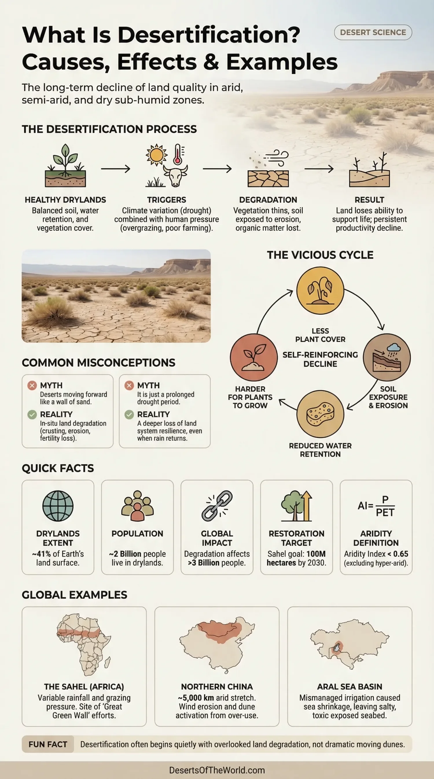
At first, the change can look small: thinner pasture, patchy vegetation, more bare ground, shorter growing seasons, salt on the soil surface, or dust lifting more easily in the wind. Then the cycle tightens. Less cover leaves the ground exposed, exposed ground erodes faster, and soil moisture slips away more quickly. Rarely does desertification begin with moving dunes. It usually begins with land degradation that people overlook for years.
| Aspect | What It Means | Useful Detail |
|---|---|---|
| Basic Meaning | Falling biological productivity in drylands | It affects soil, vegetation, water retention, and farming value |
| Where It Happens | Arid, semi-arid, and dry sub-humid regions | These drylands cover about 41% of Earth’s land surface |
| People Exposed | Communities living and working in water-limited landscapes | Roughly 2 billion people live in drylands |
| Main Drivers | Climate pressure plus land mismanagement | Overgrazing, vegetation loss, soil erosion, poor irrigation, salinization |
| Typical Signs | Less plant cover, harder soil, lower yields, more dust | Runoff rises while infiltration and soil organic matter fall |
| Why It Matters | Food, water, livelihoods, habitats, and local climate all weaken | Land degradation in a broader sense now affects more than 3 billion people worldwide |
What Desertification Really Means
The formal idea is fairly specific. Desertification refers to land degradation in dry areas caused by a mix of climatic variation and human activity. That definition matters because it separates desertification from ordinary drought. A drought is a period of low rainfall. Desertification is the deeper damage left behind when the land system itself starts losing resilience.
A dry year alone is not the whole story. Land can recover after drought if roots remain healthy, topsoil stays in place, and water still enters the ground. Desertification starts to take hold when that recovery weakens. The land becomes less buffered, less able to recover, and more fragile after each bad season.
Desertification Is Not the Same as Desert Expansion
Desertification does not mean the edge of the Sahara or the Gobi simply moves forward like a wall. Dune movement can be part of the process in some places. More often, the damage appears as soil crusting, sheet erosion, gully erosion, salinity, declining grass cover, or a slow drop in crop and pasture quality.
Vegetation can thin and soil structure can weaken before the damage becomes obvious. A field may still look usable from a distance while its organic matter, seed bank, and water-holding capacity are already declining.
Where Desertification Happens
Drylands span a large share of the planet. They cover about 41% of global land and support around 2 billion people. They include rangelands, farm belts, shrublands, seasonal grasslands, villages, towns, and river-fed production zones that depend on careful land use.
UN figures often cited in desertification work note that more than 250 million people have been directly affected, with risk spread across well over 100 countries. The burden falls hardest where soils are thin, rainfall varies sharply from year to year, and households rely closely on local land for crops, grazing, fuelwood, or water.
How Scientists Define Drylands
A technical measure often used here is the Aridity Index, usually written as AI = annual precipitation / potential evapotranspiration. It compares how much water falls from the sky with how much the climate could return to the atmosphere through evaporation and plant demand.
- Arid: AI roughly 0.05 to 0.20
- Semi-Arid: AI roughly 0.20 to 0.50
- Dry Sub-Humid: AI roughly 0.50 to 0.65
Below 0.65, land is generally treated as dryland in this context. Hyper-arid desert interiors are usually treated separately. Desertification often affects the margins and working landscapes around deserts rather than only the most barren cores.
Main Causes of Desertification
No single trigger explains every case. Desertification develops through feedback loops, and those loops differ from place to place. In one region, overgrazing may lead. In another, irrigation without drainage may salt the soil. Elsewhere, repeated drought and thinning tree cover may push the land past its recovery limits. The pattern changes, while the result remains a loss of land function.
Climate Variability and Rising Aridity
Drylands already operate close to water limits. A run of low-rainfall years, hotter conditions, stronger evaporation, or shorter wet seasons can place them under further pressure. Aridity is not the same as drought, although drought often speeds the damage. When atmospheric water demand rises faster than rainfall supply, grasses and shrubs struggle to recover, roots weaken, and more bare soil appears.
Bare soil heats faster, sheds water faster, and erodes faster. A land surface with weaker cover also traps less organic matter, so it holds less moisture in the next dry spell. The next dry year can then cause deeper damage.
Overgrazing
Overgrazing is a common driver. Grazing itself is not the problem; many dryland ecosystems evolved with herbivores. Damage begins when stocking rates remain above what the pasture can renew, or when animals concentrate around wells, roads, settlements, and fenced patches for too long.
Once grasses are grazed too short, roots shrink. Soil surface protection drops. Hooves compact the ground, and compacted soil takes in less water. Runoff rises, so even when rain falls, less of it enters the soil profile. The more exposed the soil becomes, the faster the cycle runs.
Unsuitable Farming on Fragile Soils
Some dryland soils can be productive, but they require careful timing, ground cover, and restrained use. Repeated tillage, ploughing marginal slopes, leaving fields bare between crops, removing residues, and planting without soil protection all raise risk. Topsoil is often shallow in drylands, and recovery slows sharply once it is removed.
Wind can lift fine particles away. Short, intense rainfall can strip exposed surfaces and carve rills or gullies. Crop yields may drop before the field looks visibly damaged, which is why desertification can be difficult to detect at first.
Vegetation Removal and Fuelwood Pressure
In many dry regions, trees and shrubs provide more than shade. They slow wind, anchor soil, recycle nutrients, trap litter, and help rain soak in. Removing too much woody cover strips away part of the land’s surface protection. Deforestation, heavy branch cutting, and repeated clearing can all push the land toward degradation.
Not every use of trees is harmful. The amount removed, the rate of regrowth, and the condition of the surrounding land determine the effect. On fragile ground, even a modest-looking loss of cover can alter erosion, soil temperature, and seedling survival.
Poor Irrigation and Salinization
One path to desertification runs through water management. In hot dry climates, irrigation can leave salts behind when drainage is weak and evaporation is high. Over time the root zone turns saline or alkaline. Crops weaken, soil structure worsens, and bare patches spread.
Well-managed irrigation can protect production, while poorly drained irrigation can damage it. In several dry basins, salinization has been as destructive as wind erosion.
Fire, Repeated Disturbance, and Soil Crusting
After vegetation loss, dryland surfaces can seal into a hard crust. Rain then runs off instead of soaking in. Seeds struggle to establish, and new plants emerge slowly or not at all. Repeated fire or land disturbance can shift the surface toward a harder, less porous condition.
Infiltration is one of the dividing lines between healthy and degrading dryland. Once the surface stops accepting water efficiently, even adequate rainfall brings less benefit.
What Desertification Does to Soil and Water
Soil sits at the center of the process. Desertification removes or weakens fine particles, organic matter, root channels, surface roughness, litter cover, and pore space. These features help the ground hold water, cycle nutrients, and support microbes.
Several changes often appear together:
- Lower infiltration and more surface runoff
- Higher wind and water erosion
- Loss of soil organic carbon
- Hardsetting or crust formation
- Salinity or alkalinity in irrigated dry zones
- Reduced rooting depth and weaker plant recovery
Soils under pressure also lose texture balance. Fine particles blow away or wash downslope, leaving coarser and poorer material behind. In some places, a sealed surface forms; in others, gullies cut through fields and rangelands. Both processes make the land harder to manage and less responsive after rain.
Dust and Sand Become More Mobile
When vegetation cover drops and the upper soil loosens, wind can move more material. This raises dust activity and, in some regions, sand movement. Dust affects air quality, visibility, water bodies, roads, machinery, and solar panels.
Dust storms have many sources, while land degradation and bare surfaces can increase the amount of loose material available to the wind. A dryland with firm cover releases less sediment than a surface with unprotected fine particles.
Effects on People, Farming, and Wildlife
Food Production Falls Under Stress
For farmers and pastoral communities, the first effects are often lower yields, poorer forage quality, shorter grazing periods, more failed seedlings, and higher costs for weaker returns. A pasture that carried animals for months may now hold them for weeks. A field that once handled a dry year may fail after one weak rainy season.
Desertification affects both ecology and land productivity. When the land stops buffering weather swings, livelihoods become more fragile.
Water Becomes Less Reliable
Degraded land often stores less water. Streams may rise and fall more sharply after storms because more rain runs off the surface instead of soaking in. Wells and shallow groundwater can come under pressure when recharge weakens. Water quality may also decline where sediment loads rise or salts accumulate.
Desertification can produce too little water in the soil and too much fast runoff on the surface at the same time. This combination is common in damaged drylands.
Biodiversity Shrinks
As plant cover simplifies, habitats simplify with it. Palatable grasses may disappear first, followed by shrubs or trees that depended on better soil moisture. Insects, reptiles, birds, and mammals that rely on mixed vegetation lose shelter and food. Biodiversity declines as the land becomes drier, more uniform, and less stable.
Even when species do not vanish entirely, their ranges can fragment. Recovery becomes patchier as healthy habitat is separated by exhausted ground.
Human Pressure Rises as Land Quality Falls
When good pasture contracts or cropland weakens, the remaining productive patches are used more heavily. This can create a cycle of rising pressure on a shrinking area of usable land. Desertification is therefore both a result and a multiplier of land stress.
Across the wider issue of land degradation, global estimates point to impacts on more than 3 billion people. Drylands carry a large share of that pressure because rainfall is limited and recovery margins are narrow.
Examples of Desertification Around the World
The Sahel
The Sahel is the long semi-arid belt south of the Sahara, and it is one of the best-known desertification zones on Earth. Rainfall varies sharply from year to year. Population growth, grazing pressure, wood harvesting, and drought have all shaped the land. In many local landscapes, the visible signs include bare crusted surfaces, weaker grass cover, and reduced soil fertility.
Restoration efforts linked to the Great Green Wall aim by 2030 to restore 100 million hectares of land, store 250 million tonnes of carbon, and create 10 million jobs. These targets show the scale of land and water management planned across the region.
Recent work also shows measurable recovery on the ground. By June 2026, the Sahel Integrated Resilience Initiative had restored more than 335,000 hectares of degraded land across Burkina Faso, Chad, Mali, Mauritania, and Niger. The programme had benefited more than 4 million people through a mix of land rehabilitation, soil and water management, livelihood support, and food-system measures.
Northern China and the Mongolia Borderlands
Another widely cited zone lies across northern China and nearby borderland drylands toward Mongolia. FAO material describes a roughly 5,000 km arid stretch in northern China where climate pressure and human use have accelerated degradation. Overgrazing, vegetation clearing, cultivation on sandy land, and poor soil protection have all played a role.
In these areas, the problem often appears as wind erosion, grassland decline, dune activation in some places, and more frequent dust movement. Similar processes occur wherever dryland use exceeds the land’s capacity to recover.
The Aral Sea Basin
The Aral Sea Basin represents a water-driven path into desertification. Large-scale water diversion for irrigation helped shrink one of the world’s major inland water bodies. As shorelines retreated, exposed salty sediments and degraded surrounding lands created a harsher surface environment.
Mismanaged water contributed to land degradation, salinity, dust, and falling biological productivity at the same time. The case shows how poor water management in dry climates can damage land as deeply as prolonged rainfall shortage.
There has been a partial recovery in the North Aral Sea, which is separated from the larger southern remnants by the Kok-Aral dam. Kazakhstan’s Ministry of Water Resources and Irrigation reported that North Aral water volume reached about 23.4 billion m³ on 10 August 2026, up from 18.9 billion m³ in 2022. This is a recovery of the northern basin only; it does not mean that the former Aral Sea as a whole has been restored.
Mediterranean Europe
Mediterranean landscapes contain many areas with seasonal drought, thin soils, steep slopes, intense rain bursts, fire risk, and long histories of cultivation and grazing. Under these conditions, erosion and vegetation loss can combine with warming and dryness to raise desertification sensitivity.
European assessments have repeatedly treated the Mediterranean as one of the most exposed regions in Europe. Spain, Portugal, Italy, Greece, and other dry southern areas are often included in monitoring work because they show the combined effects of water stress, soil erosion, land-use pressure, and declining resilience.
COP17 Outcomes and 2026 Land Restoration Update
The 17th session of the UNCCD Conference of the Parties, or COP17, was held from 17–28 August 2026 in Ulaanbaatar, Mongolia, under the theme “Restoring Land, Restoring Hope”. The meeting brought desertification, land degradation, drought, rangelands, soil health, restoration, and finance into the same negotiating process. Work also continued on the UNCCD’s post-2030 strategic direction.
COP17 ended with decisions across several areas, including rangelands, programme and budget matters, and continued work on future UNCCD priorities. On drought, however, Parties did not reach agreement on a global legally binding instrument. The adopted drought decision keeps the issue under negotiation, makes drought a stand-alone agenda item at COP18, and calls for intersessional work on proactive drought management. COP18 is due to be held in Egypt in 2028.
Land Degradation Neutrality Links Prevention With Restoration
Land Degradation Neutrality, usually shortened to LDN, remains one of the main UNCCD approaches for tracking whether land condition is being maintained or improved. The response order is avoid, reduce, then reverse: protect healthy land from new damage, reduce degradation where it is already occurring, and restore land whose functions have declined.
UNCCD reporting uses three minimum land indicators for this work: land-cover change, land productivity, and soil organic carbon. These measures help separate visible short-term greening from longer recovery in soil condition and productive capacity. A site can regain plant cover while still showing weak soil carbon or unstable productivity.
Why Rangelands Drew Attention at COP17
COP17 took place during the United Nations International Year of Rangelands and Pastoralists 2026. This gave added attention to grazing lands, pastoral livelihoods, vegetation recovery, soil protection, and drought planning. For desertification, the connection is direct: rangelands can remain productive under dry conditions when grazing pressure, water access, plant recovery, and soil cover stay within the land’s capacity to renew.
How Experts Track Desertification
Scientists do not rely on a single sign. They monitor clusters of change. A landscape may be flagged by falling vegetation cover, more bare ground, lower soil organic carbon, weaker infiltration, rising salinity, wind erosion scars, reduced yield stability, or more active dust emission. Satellite records help, while field evidence remains necessary.
Among the most useful indicators are:
- Vegetation cover trends
- Soil organic carbon
- Land productivity
- Salinity and alkalinity
- Runoff and infiltration behavior
- Extent of bare soil
- Wind and water erosion features
A place can look greener after one wet year and still be degrading below the surface. Roots may be shallower, salts may be rising, and the soil may be losing structure even when the color from above looks better. Desertification is often easier to identify across several seasons than in a single snapshot.
Why Desertification Spreads So Easily Once It Starts
Drylands operate on narrow margins. A small drop in cover can lead to a larger drop in infiltration. A small rise in runoff can lead to greater soil loss. A thin crust can block seedling establishment. These linked effects turn land degradation into a self-reinforcing cycle.
Recovery remains more realistic while plants, roots, soil pores, and surface roughness are still present. Once topsoil, seed reserves, and water pathways are badly damaged, the same rainfall supports much less plant growth.
Sources
- UNCCD – COP17 Overview (official dates, host city, theme, and conference context)
- UNCCD – COP17 Official Documents (adopted and draft decisions, including drought, future UNCCD priorities, rangelands, and budget matters)
- FAO – Status of the World’s Soil Resources 2026 at COP17 (27 August 2026 launch; global soil-condition, erosion-management, and erosion-trend findings)
- IISD Earth Negotiations Bulletin – UNCCD COP17 Summary (negotiated outcomes, drought decision, and issues carried forward to COP18)
- UNCCD – Article 1: Use of Terms (formal definitions of desertification, land degradation, drought, and drylands)
- UNCCD – Land Degradation Neutrality Overview (LDN definition and the avoid, reduce, reverse response order)
- UNCCD – Land Degradation Neutrality Principles (implementation principles and land-cover, productivity, and soil-carbon indicators)
- UNCCD – Desertification Overview (official overview of desertification and dryland degradation)
- UNCCD Library – What Is Desertification, and Where Is It Happening? (plain-language explanation, dryland context, and regional examples)
- UNCCD – Desertification: Its Effects on People and Land (figures on dryland extent, affected populations, and economic impacts)
- FAO – What Lands and Areas Are Prone to Desertification? (drivers, vulnerable land types, and land-use pressure)
- FAO – Overview of Land Desertification Issues and Activities in China (technical regional example from northern China)
- IPCC – Desertification Chapter (scientific treatment of definitions, aridity classes, and land-climate links)
- European Court of Auditors – Desertification in the EU (Mediterranean and European dryland context)
- European Environment Agency – Sensitivity to Desertification and Drought in Europe (regional exposure in the Mediterranean basin)
- UNEP – Great Green Wall in the Sahel (restoration targets and Sahel land recovery context)
- UNEP – Sahel Integrated Resilience Initiative (more than 335,000 hectares restored and more than 4 million people benefited by June 2026)
- Kazakhstan Ministry of Water Resources and Irrigation – North Aral Recovery (North Aral water volume of 23.40 billion m³ on 10 August 2026)