Location & Continent
Continent: North America
Country: United States (primarily Wyoming; edges into CO/UT/ID/MT within the broader ecoregion)
Coordinates: 41.9°N, 108.6°W (Great Divide Basin, heart of the Red Desert)
Wyoming Basin Desert – Map & Street View
Click to load the interactive map
Physical Features
Area: Wyoming Basin ecoregion ~133,656 km²; Red Desert core ~24,000 km²; Great Divide Basin ~10,260 km² (endorheic “closed” basin)
Length: ~600+ km across the ecoregion (NW–SE), with desert/steppe expanses around the Continental Divide
Width: ~200–350 km depending on sub-basin (e.g., Great Divide, Green River, Wind River margins)
Elevation: Mostly 1,800–2,200 m (≈6,000–7,200 ft); a high-altitude desert/steppe between the Rockies and intermontane uplifts
Climate & Precipitation
Temperature: Hot, dry summers that can reach 35–40 °C; long, cold winters with lows below −25 °C (occasionally colder during Arctic outbreaks).
Precipitation: ~100–200 mm annually in the driest basins; strong rain-shadow and high evaporation. Snowfall occurs in winter and early spring, but moisture is scarce overall.
Ecological Features
Ecozone: Nearctic
Biome: Temperate desert & cold sagebrush steppe
Ecoregions: Wyoming Basin (Level III, EPA), with sub-basins including the Red Desert and the Great Divide Basin
Flora & Fauna
Flora: Big sagebrush (Artemisia tridentata), greasewood (Sarcobatus), saltbush (Atriplex), rabbitbrush (Chrysothamnus/Ericameria), bunchgrasses, and alkali-flat specialists. Spring moisture sparks brief wildflower flushes.
Fauna: Pronghorn (one of North America’s largest migratory herds), mule deer, desert-adapted elk, sage-grouse, golden eagles, ferruginous hawks, pygmy rabbits, coyotes, red foxes, badgers, prairie rattlesnakes, leopard lizards, and diverse songbirds along riparian ribbons.
Geology & Notable Features
Geology: Intermontane basins sculpted during the Laramide orogeny, floored by thick Eocene–Cretaceous sediments. The Great Divide Basin is endorheic (no outlet to the ocean); widespread eolian sands, alkali flats, and stabilized dune fields reflect persistent wind and aridity.
Notable Features: Killpecker Sand Dunes (largest “living” dune system in the U.S.), Boar’s Tusk volcanic neck (lamproite), Adobe Town badlands, the Continental Divide “loop” that encloses the Great Divide Basin, historic rail and highway corridors (Union Pacific & I-80) crossing the southern Red Desert, plus extensive oil, gas, and uranium fields.
Introduction
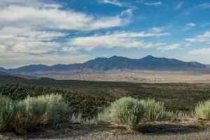
The Wyoming Basin is a geographic region in the western United States known for its dry climate, varied ecosystems, and geological history. Surrounded by mountain ranges, it includes a mix of basins, plains, and uplands that support different plant and animal communities. This section outlines its physical features, climate patterns, flora and fauna, economic role, and how it compares with other desert regions.
Geography
The Wyoming Basin lies primarily in the state of Wyoming but also extends into eastern Utah and western Colorado. It is surrounded by the Rocky Mountains to the west, the Black Hills to the northeast, and the Wind River Range to the east. The basin itself consists of a series of valleys, rolling hills, and plateaus that offer both dramatic vistas and subtle, understated beauty. Here’s a breakdown of key geographical features:
Key Geographic Features
| Feature | Description |
|---|---|
| Elevation | Average elevation ranges from 5,000 to 7,500 feet |
| Climate | Cold desert climate with hot summers and cold winters |
| Major Rivers | Includes parts of the Green River and North Platte River |
| Soil Types | Predominantly sandy and silty soils |
Climate
The climate of the Wyoming Basin is classified as a cold desert climate, characterized by its stark temperature variations and limited precipitation. Average annual rainfall is approximately 5 to 10 inches, with most precipitation occurring during the summer months. Winter months can see temperatures plunge to as low as -20°F, while summer peaks can reach over 90°F. Here’s a summary of the climatic conditions:
Climatic Characteristics
| Type | Details |
|---|---|
| Average Temperature Range | -20°F to 90°F |
| Annual Precipitation | 5-10 inches |
| Humidity Levels | Low humidity, averaging around 30-40% |
Flora and Fauna
The unique climate and soil types in the Wyoming Basin support a variety of plant and animal species, adapted to thrive in a desert environment. Vegetation primarily consists of sagebrush, grasses, and various drought-resistant shrubs. Common animal species include:
Common Flora and Fauna
| Type | Common Species |
|---|---|
| Flora | Greater sage grouse, rabbits, and desert wildflowers |
| Fauna | Pronghorn antelope, coyotes, and various bird species |
Economic Significance
The Wyoming Basin supports several economic activities, including agriculture and energy production. The region contains mineral resources such as coal, oil, and natural gas, which play a central role in its economy:
Key Economic Activities
| Industry | Details |
|---|---|
| Energy Production | Oil and coal mining are major parts of the regional economy |
| Agriculture | Mostly grazing due to low precipitation |
| Tourism | Attracts visitors for its natural beauty and outdoor recreation |
Comparison with Other Desert Regions
When contrasting the Wyoming Basin with other deserts such as the Sonoran Desert or the Great Basin Desert, some distinctive differences emerge:
Desert Comparison Table
| Feature | Wyoming Basin | Sonoran Desert | Great Basin Desert |
|---|---|---|---|
| Climate | Cold desert | Hot desert | Cold desert |
| Average Rainfall | 5-10 inches | 3-15 inches | 5-10 inches |
| Elevation | 5,000-7,500 feet | Sea level to 4,000 feet | 4,000-7,000 feet |
| Typical Vegetation | Sagebrush, grasses | Cacti, shrubs | Sagebrush, saltbush |
Conclusion
The Wyoming Basin is a cold desert region defined by its climate, ecosystems, and mineral resources. It supports a range of plant and animal species and contributes to the economy of nearby communities. Its ecological conditions and resource use shape the character of this desert basin.
References
Government / Official Sources
USGS — “Wyoming Basin Rapid Ecoregional Assessment” (area, habitats)
US EPA — “Level III & IV Ecoregions by State” (Wyoming Basin classification)
Wyoming State Climate Office — Climate Atlas (basin dryness & precipitation)
U.S. Bureau of Land Management — Boar’s Tusk site page
University / Encyclopedic Sources
Encyclopædia Britannica — “Wyoming: Climate” (arid/steppe ranges and precipitation)
Wikipedia — “Red Desert (Wyoming)” (regional overview & wildlife)
Wikipedia — “Great Divide Basin” (endorheic basin facts)