A desert beside the sea feels almost wrong at first glance. People expect shorelines, clouds, and fresh sea air to mean moisture. Yet some coasts stay stubbornly dry year after year. That contrast is exactly what makes coastal deserts so fascinating: they sit at the meeting point of ocean, atmosphere, rock, and life, but they do not behave like wet coasts at all.
Atlantic Coastal Desert
Location & Continent Continent: Africa Countries / Regions: Mauritania, Western Sahara (region) Desert System: Western Sahara Edge of...
Read More →Eritrean Coastal Desert
Location & Continent Continent: Africa Countries: Eritrea, Djibouti Coordinates (approx.): 13°N, 42°E – along the southern Red Sea...
Read More →Sechura Desert
Location & Continent Continent: South America Countries: Mainly Peru; parts of the broader ecoregion extend into coastal Ecuador...
Read More →Atacama Desert
Photos of the Atacama Desert Location & Continent Continent: South America Countries: Mainly northern Chile; some broader definitions...
Read More →Baja Californian Desert
Baja California Desert — Location & Continent Continent: North America Country: Mexico (Baja California; Baja California Sur) Coordinates:...
Read More →Namib Desert
Location & Continent Continent: Africa Countries: Namibia, Angola, South Africa Coordinates: Approximately 23°S, 15°E Photos of the Namib...
Read More →6 inventions in Coastal Deserts
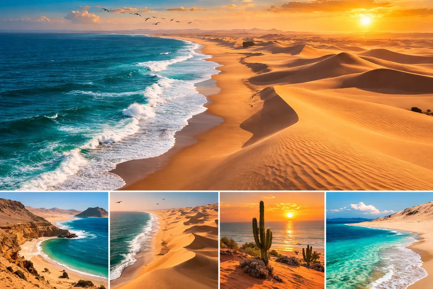
These landscapes are part of the wider desert story, and deserts as a whole cover roughly one-fifth of Earth’s land surface. Coastal deserts form only a small slice of that total, but they punch far above their size in terms of climate science, biogeography, fog ecology, and surface processes. They also produce some of the planet’s most unusual scenery: fog-fed dunes, salt flats, lomas hills, marine terraces, wind-carved gravel plains, and dry shorelines that sit next to some of the richest fishing waters on Earth.
On this page, the focus stays on six ocean-edge deserts that anchor the topic especially well: the Atlantic Coastal Desert, the Eritrean Coastal Desert, the Sechura Desert, the Atacama Desert, the Baja Californian Desert, and the Namib Desert. Together they show that “coastal desert” is not one single template. Some are cool and foggy. Some are blisteringly hot. Some are built around giant dune fields, while others are gravel plains, salars, low terraces, or rocky coasts. Same broad category. Very different expressions.
Main Idea
What links these regions is not just dryness near the sea. It is the way marine influence, air circulation, cold currents, temperature inversions, and terrain combine to keep rainfall low while still allowing fog, dew, sea mist, or rare runoff to shape life on the ground.
What Makes A Coastal Desert Different
A desert is usually defined by very low annual precipitation, often around 250 mm or less. Coastal deserts fit that broad arid threshold, but their climate has an extra twist: the nearby ocean often supplies humidity without rain. That distinction matters. In many inland deserts, the air is dry and the story ends there. In coastal deserts, the air can be damp, the morning can be misty, and yet the ground may still receive almost no measurable rainfall.
This is why coastal deserts can look deceptively gentle. Temperatures are often less extreme than in continental hot deserts, at least near the shore. Fog banks drift inland. Low clouds hang over the coast. The scene can feel muted rather than fiery. But aridity is still the ruling condition. Soil moisture remains low, runoff is episodic, plant cover is sparse over large tracts, and biological activity often depends on tiny windows of water input from fog, dew, or rare storms.
Another feature sets them apart: the desert and the sea are tightly linked. Offshore upwelling can cool the air, suppress rainfall, and support productive marine food webs at the same time. The result is one of the sharpest ecological contrasts on Earth. On one side, nutrient-rich waters support fish, seabirds, seals, turtles, and coastal wetlands. On the other side, a few kilometers inland, gravel plains or dunes may receive barely enough water to support lichens, low shrubs, succulents, or annual blooms after rare wet pulses.
That tension between marine abundance and terrestrial scarcity is not just scenic. It is a working Earth-system pattern. And coastal deserts show it clearly.
How Ocean-Edge Aridity Forms
Cold Currents And Coastal Upwelling
Many of the best-known coastal deserts sit beside cold eastern boundary currents. Along western continental margins, currents such as the Humboldt Current, the Benguela Current, the Canary Current, and the California Current cool the lower atmosphere. Winds can also drive upwelling, which lifts colder deep water toward the surface. Cold surface water means less evaporation into warm rising air, and that helps keep rainfall weak.
The effect is subtle but powerful. Air that passes over cold water becomes cooler and more stable. Stable air resists the vertical uplift needed for rain clouds to grow. So the coast may fill with low cloud and fog, yet the rainfall mechanism never really gets going. The sky looks active, but the rain budget stays tiny.
This is one reason the Pacific side of South America and the Atlantic side of southern Africa host such famous arid belts. In the Atacama and the Namib, the offshore current is not a side note. It is part of the climate engine itself. Fog, low stratus, and temperature moderation near the shore all tie back to cold ocean water and the stable air mass above it.
Subsiding Air And Subtropical High Pressure
Cold currents do not work alone. Many coastal deserts also lie under the influence of subtropical high-pressure belts. In these zones, air descends rather than rises. Descending air warms and dries as it sinks, which suppresses cloud growth and rainfall. So even when the ocean is nearby, the larger atmosphere favors clear skies, weak convection, and aridity.
This is why some of the driest coasts on Earth lie not in the deep interior of continents but near the western margins of the subtropics. The ocean keeps the near-surface air cool. The subtropical circulation keeps the atmosphere stable aloft. Put those pieces together and you get a coast that is humid in feel, dry in hydrology.
Temperature Inversions
In many coastal deserts, the air near sea level is cooler than the air above it. That setup creates a temperature inversion. Normally, warm air near the surface rises. Under an inversion, the lower layer is trapped. Fog and low cloud can form inside that shallow cool layer, but they struggle to build into tall rain-bearing clouds.
The Atacama is a classic example. Along parts of the Chilean coast, cold upwelled water helps produce a low, stable marine layer. Fog forms, slopes catch moisture, and yet rain may stay absent for years. In the Namib, the same broad logic applies: fog drifts inland under a stable air structure, and the desert remains almost rainless near the coast.
Fog is not failed rain. In coastal deserts, fog is often the main water pathway that actually reaches living things on the ground.
Rain Shadows Still Matter
Some coastal deserts also sit beside mountains that cut off moisture from the continental side. The Andes strengthen the Atacama’s dryness by blocking humid air masses. In other words, the Atacama is dry not because of one single cause, but because several dry-making processes line up at once: a cold offshore current, stable high-pressure air, and mountain blocking. When multiple barriers stack together, hyperaridity can emerge.
That layered explanation is worth stressing. Many short articles reduce coastal deserts to “cold current = dry coast.” That is too simple. The actual climate result depends on ocean temperature, wind direction, inversion strength, topography, seasonal circulation, and how often large-scale anomalies like El Niño disrupt the pattern.
Not Every Coastal Desert Is A Cool Fog Desert
This is where the category gets more interesting. The Eritrean Coastal Desert shows that coastal aridity does not always mean cool air and classic west-coast fog-desert conditions. Along the southern Red Sea and the Bab-el-Mandeb region, the climate is extremely hot, rainfall is still low, and marine influence works differently. The coast matters, yes, but the resulting desert is hotter, flatter, and less fog-defined than the Namib or Atacama.
So the label coastal desert covers more than one climate flavor. Some are cool coastal deserts. Some are hot coastal deserts. Some depend heavily on fog interception. Others receive slightly more scattered rainfall or seasonal marine moderation without building a true fog-water economy. Same family, different branch.
Where The Water Really Comes From
Fog, Sea Mist, And “Occult” Moisture
In coastal deserts, water often arrives in ways that do not show up well in a normal rainfall total. Fog droplets can condense on leaves, twigs, lichens, beetle bodies, stones, nets, or rough ground surfaces. This is sometimes called occult precipitation—water input that is not measured as ordinary rain but still matters ecologically.
The best known examples come from the Namib and the Atacama-Sechura belt. In the Namib, fog can be the main water source for small desert organisms. Darkling beetles, dune grasses, lichens, and some shrubs exploit it directly or indirectly. In the Atacama and Peruvian coastal hills, fog supports lomas ecosystems—patchy green islands that appear on slopes where low clouds and mist are intercepted efficiently.
Fog behaves like a thin airborne river. It does not flood valleys, but it can feed life one droplet at a time. Strange system, maybe. Effective system, absolutely.
Dew And Surface Condensation
Where the atmosphere stays near saturation, dew can matter almost as much as fog. In the Namib, dew is heavy enough in some zones to outrank rainfall for certain plants. This changes the whole surface ecology. A desert does not need lush soils to respond to a little water. Crusts, annual seeds, lichens, microbes, and shallow-rooted plants can all exploit small, repeated moisture pulses if the timing fits.
That is why coastal desert surfaces often show fine-scale ecological patterning. One slope, ridge crest, pebble field, or dune face may collect more condensation than the next. A few meters can separate bare ground from a belt of lichens, succulents, or fog-fed herbs.
Rare Rain Pulses And Climate Swings
Rain is sparse in these regions, but when it does arrive, it can reshape the desert quickly. Along the Atacama and Sechura coast, El Niño years can bring unusual moisture, flash floods, short-lived stream activity, and sudden vegetation bursts. Dry channels wake up. Seeds germinate. Annual herbs spread fast. Coastal hills can green in places that looked empty only weeks before.
These pulses matter because they reset biological cycles. Seed banks, insect populations, bird movement, and shrub recruitment may all respond to rare wet years. So even the driest coastal deserts are not static. They run on long waits and short bursts. Months of almost nothing, then a brief ecological rush.
Groundwater, Wetlands, And River Crossings
Another overlooked point: many coastal deserts are not uniform dry blankets. They are broken by wetlands, salars, oases, ephemeral rivers, and groundwater-fed pockets. The Sechura Desert includes coastal wetlands that matter for migratory birds. The Atlantic Coastal Desert supports marshlands and shallow coastal systems tied to the East Atlantic Flyway. The Namib has ephemeral river corridors where larger trees and mammals can persist. These are not side details. They are part of the desert architecture.
So when people picture coastal deserts as empty sand beside the sea, they miss the real pattern. A better image is this: a dry matrix with scattered moisture nodes. Some nodes are fog slopes. Some are wetlands. Some are river mouths or pans. Some are marine caves, tidal flats, or mangrove edges. Life clusters around those breaks in the dry field.
Landforms You See Again And Again
Coastal deserts come in many shapes, but a few landforms repeat often enough to become diagnostic.
- Dune fields: mobile or partly stabilized sand bodies, from the giant Namib dune systems to Baja’s coastal dunes.
- Gravel plains: common where fine material has been removed by wind, leaving stony pavements and desert varnish surfaces.
- Salt flats and salars: especially strong in the Atacama system, where evaporation far exceeds precipitation.
- Marine terraces and cliffs: uplifted or wave-cut coastal surfaces that create sharp shore-desert boundaries.
- Fog slopes and lomas hills: relief that catches low cloud and supports seasonal vegetation.
- Ephemeral channels and wadis: dry most of the time, then active during rare runoff events.
- Coastal marshes, lagoons, and mangrove pockets: more common where local topography and salinity allow water to linger.
Each landform tells part of the story. Dunes point to wind and sand supply. Salt crusts point to closed drainage and fierce evaporation. Fog slopes point to marine-layer condensation. Marshes and lagoons point to the narrow places where desert, sea, and groundwater overlap. Put together, these surfaces let you read a coastal desert almost like a climate map written in rock and sediment.
Main Coastal Deserts Covered On This Page
| Desert | Coast And Region | Approximate Scale | Typical Moisture Pattern | Marine Driver Or Setting | Standout Feature |
|---|---|---|---|---|---|
| Atlantic Coastal Desert | Atlantic coast of Mauritania and Western Sahara region | About 40,000 km² | Usually under 50 mm of rain a year; fog and sea mists matter | Cool Canary Current and coastal marsh systems | Huge bird concentrations and monk seal habitat |
| Eritrean Coastal Desert | Southern Red Sea coast of Eritrea and Djibouti | About 4,600 km² | Less than 100 mm annually; very hot air and variable rain | Red Sea margin and Bab-el-Mandeb setting | Major raptor migration corridor and mangrove-fringed pockets |
| Sechura Desert | Peruvian Pacific coast, with the broader ecoregion tied to the coastal desert belt | About 185,000 km² | About 100 mm in low areas, up to around 200 mm in higher ground | Cold Pacific waters, marine fog, and coastal wetlands | South America’s broadest desert belt and fog-fed hills |
| Atacama Desert | Pacific coast of northern Chile and adjoining arid fringe toward Peru | About 1,000–1,100 km long | Some central sectors average under 5 mm a year | Humboldt Current, inversion layer, and Andes rain shadow | Hyperaridity, salars, fog oases, and ultra-dry air |
| Baja Californian Desert | Pacific side of the Baja California Peninsula, Mexico | About 77,890 km² | Driest areas under 50 mm annually; some fog and summer pulses | California Current and coastal dune systems | High peninsula endemism and boojum landscapes |
| Namib Desert | Atlantic coast of Angola, Namibia, and South Africa | About 1,900 km long; UNESCO sand sea over 3 million ha | About 13 mm at the coast, rising inland in places to roughly 51 mm | Benguela Current, fog, and vast dune transport system | World-famous fog desert with giant dune fields |
Atlantic Margin Coastal Deserts
Atlantic Coastal Desert
The Atlantic Coastal Desert forms a narrow arid fringe along the northwestern African coast, mainly in Mauritania and the Western Sahara region. Its land area is about 40,000 km², which makes it smaller than some of the giant continental deserts people usually picture, but its ecological reach is bigger than that number suggests. This is not just a strip of dry shore. It is a meeting zone between desert plateaus, coastal swamps, shallow marine banks, rocky cliffs, and migratory bird routes.
The climate is hot and arid, with rainfall often below 50 mm a year. Some years may pass with almost no rain at all. Yet the coast is not waterless in a biological sense. Sea mists and fog tied to the Canary Current add moisture to the surface environment. That extra dampness supports lichens, halophytic plants, sparse shrubs, and low vegetation that would struggle farther inland. On paper the rainfall total looks tiny. On the ground, the coast still carries a faint marine fingerprint.
Geomorphically, the desert shows a mixed face. There are sandy stretches, cliffs, rocky plateaus, and coastal flats, along with marshes and shallow-water systems that sit beside one of the most productive marine zones in the eastern Atlantic. That land-sea pairing is one of the area’s defining traits. The terrestrial side is dry and open. The marine side is biologically busy. The edge between them is sharp, but not empty.
Bird life gives this coastal desert much of its global weight. Marshlands and coastal shallows along this belt support enormous numbers of migratory shorebirds. A large share of the waders that use the East Atlantic Flyway winter here, especially around wetland systems such as the Banc d’Arguin area. For birds moving between Europe, Greenland, Siberia, and West Africa, this coast acts as a seasonal service station—resting ground, feeding ground, and survival zone all at once.
Marine fauna also stand out. The coast near Cap Blanc is known for the Mediterranean monk seal, one of the world’s rarest seal species. Offshore waters support turtles, dolphins, and fish-rich food webs. That makes this desert different from a purely inland arid belt. Its biological story cannot be told from land alone. The sea is half the plot.
Vegetation remains sparse overall, but it is not featureless. Salt-tolerant plants dominate parts of the shoreline, while dune and plateau surfaces hold hardy shrubs and grasses adapted to saline soils, wind abrasion, and long dry spells. In places, moisture from fog gives just enough relief for a patchwork of life to establish where rainfall alone would not support it.
Another reason this desert matters is its structure as a transition belt. It is not a giant inland core like the central Sahara. It is the thin, maritime edge of a much larger dry system. That edge function changes everything. Wind direction matters more. Fog matters more. Shorebirds matter more. Marine productivity matters more. Coastal erosion, sand extraction, wetland pressure, and fisheries all affect the region in ways that do not define most inland deserts.
So, yes, it is dry. Very dry. But it is also one of the clearest examples of a coastal desert behaving as a two-sided environment: arid on land, biologically rich at sea, and full of narrow ecological corridors where the two meet.
Namib Desert
The Namib is one of the planet’s best-known coastal deserts and one of the oldest major deserts still active today. It stretches for about 1,200 miles (1,900 km) along the Atlantic coast from Angola through Namibia into South Africa, reaching inland roughly 130–160 km in many sectors. That long, narrow geometry is one reason the desert feels so distinctive. It is not simply “by the sea.” It runs with the sea for a huge distance.
The offshore climate control is the Benguela Current. Cold water cools the lower atmosphere, helps create a marine inversion, and generates fog that drifts inland on sea breezes. Near the coast the Namib is almost rainless; average annual precipitation can be as low as 13 mm, rising inland in many areas toward roughly 51 mm at the foot of the escarpment. Dew is heavy enough in some zones to matter more than rain. That alone tells you what kind of desert this is.
The coastal strip is cooler than many readers expect. Day-night and seasonal contrasts near the sea are narrower than in most hot deserts, because the ocean smooths the temperature curve. Inland, conditions become hotter and more variable. The fog belt, then, is not just a weather detail. It is a real ecological boundary, and life responds to it closely.
The Namib is famous for its dune systems, and for good reason. The desert includes some of the largest and most striking dunes on Earth. In the southern part, large linear dunes run in long parallel belts; individual dunes can extend for many kilometers and reach impressive heights. UNESCO describes the Namib Sand Sea as the world’s only coastal desert with extensive dune fields influenced by fog. The World Heritage property alone covers over 3 million hectares, with a further buffer zone outside it.
Yet the Namib is not only dunes. It also includes gravel plains, coastal flats, inselbergs, playas, ephemeral rivers, and rocky ground. That diversity matters because different moisture pathways work in different landforms. Fog may dominate one zone. Episodic river flow may shape another. Sand movement rules the dunes. Salt and gypsum shape some flats. You can drive across a short transect here and pass through several desert worlds in one go.
The biological adaptations are famous because they are so readable. Darkling beetles collect fog moisture. Welwitschia, perhaps the desert’s most iconic plant, survives in arid ground with astonishing longevity and unusual leaf growth. Lichens thrive in fog-affected belts. Dune grasses and succulents use tiny water windows. Larger fauna—oryx, springbok, ostrich, jackal, and in some river-fed sectors even elephant and lion—show that “desert” does not mean lifeless. Far from it.
The coast adds still more layers: seal colonies, flamingos, pelicans, shorebirds, and offshore fisheries tied to the Benguela upwelling system. Again, the land looks spare while the adjacent ocean can be highly productive. Few places display that contrast as cleanly as the Namib coast.
There is also a process story here that makes the Namib a favorite of geomorphologists. UNESCO describes a three-part conveyor system: material is eroded inland, moved by rivers, redistributed by ocean currents, and then reworked by wind into the coastal dune field. In other words, the dunes are not just sand piles sitting still. They are the visible outcome of river transport, marine redistribution, and aeolian shaping.
Small wonder the Namib matters far beyond southern Africa. It is a living reference point for fog ecology, desert geomorphology, biomimicry, and climate-desert interactions. When people talk about coastal deserts, the Namib is often the benchmark. And honestly, that reputation is earned.
Pacific Margin Coastal Deserts
Sechura Desert
The Sechura Desert occupies the western subtropical edge of South America along the coast of Peru and is part of the broader Pacific coastal desert belt. In ecoregion terms it covers around 18.5 million hectares, or roughly 185,000 km², making it the most expansive desert belt in South America. Even so, it is often overshadowed by its drier southern neighbor, the Atacama. That is a mistake. The Sechura has its own climate logic, landforms, and ecological identity.
Its aridity still ties back to the cold Pacific, but the Sechura is not just “a slightly wetter Atacama.” Lowland precipitation can reach around 100 mm a year, with higher areas in the ecoregion getting around 200 mm. Average annual temperatures sit near 22°C. Fog formed over the cold sea often dissipates between 700 and 1,000 meters, and exposed slopes intercept that moisture, supporting local vegetation. So while the desert is dry overall, it contains more seasonal greening, fog-supported hills, and coastal wetland influence than many people expect.
The landscape is varied. There are sand dunes, coastal plains, rocky scrublands, cactus-bearing slopes, and wetlands near the shore and in lower-lying sectors. Some valleys support willows and other moisture-tolerant plants. In the north, carob and mesquite become more common. In wet pulses—espesially during stronger El Niño phases—annual herbs can spread across surfaces that are usually bare or only thinly vegetated.
That pulse-driven structure is one of the Sechura’s defining traits. The desert often sits in a waiting state. Then a warm Pacific anomaly changes the hydrologic mood, sometimes fast. A coastal desert that looks quiet in one year can bloom, flood, or shift in vegetation cover the next. This makes the Sechura a useful place for studying interannual variability rather than only long-term average dryness.
Biologically, the Sechura supports several species tied closely to this environment. The Sechuran fox is perhaps the best known mammal associated with the desert. It is adapted to a sparse, dry habitat and can persist with little access to surface water. The ecoregion also includes endemic reptiles, butterflies, and birds, along with coastal wetlands that are internationally valuable for migratory species. Several wetland sites in the region have Ramsar recognition, which makes sense given how rare and important water nodes are in this desert belt.
There is also a strong human-geography dimension. The Sechura corresponds to part of Peru’s most populated coastal zone, so pressure from urban growth, agriculture, livestock, and water use is never far away. That does not erase the desert character, but it does mean the Sechura often appears as a working desert landscape rather than a remote empty one. Coastal wetlands, valley agriculture, transport corridors, and settlements all sit in close proximity to arid landforms.
For readers trying to understand coastal deserts globally, the Sechura fills an important gap. It shows that an ocean-edge desert can be broad, populated, seasonally responsive, and wetland-linked without losing its desert identity. It also serves as a bridge between fully hyperarid systems and more variable maritime drylands. Not the driest of the group. Still one of the most instructive.
Atacama Desert
The Atacama Desert is the coastal desert that nearly everyone has heard of, and there is a reason it dominates the category. It extends through northern Chile for roughly 600 to 700 miles (1,000 to 1,100 km) and belongs to one of the most arid settings on Earth. In some sectors, average annual rainfall is less than 5 mm. Other local areas may go years without rain, and some records point to rain touching certain surfaces only a handful of times in a century.
Its dryness is not the result of a single control. The Humboldt Current cools the lower atmosphere offshore. The subtropical high promotes descending, stable air. The Andes limit moisture from the east. The coastal range shapes where the marine layer can penetrate. Put together, those factors create a desert where hyperaridity is not an exaggeration but a working climate condition.
Along the coast, cold upwelled water helps produce fog and low stratus. Yet that fog rarely turns into rain. Instead, it feeds localized moisture systems such as camanchaca fog and slope-bound fog oases. On select hills and ridges, especially where topography catches the marine layer, vegetation can appear in narrow bands or seasonal patches. These lomas-type systems are easy to underestimate if one only looks at rainfall averages. A desert can be nearly rainless and still have fog ecology. The Atacama proves it plainly.
Surface forms in the Atacama are just as memorable as the climate. The desert contains salt flats, alluvial fans, volcanic cones, gravel plains, dune fields, and mineral-rich basins. The Salar de Atacama is especially well known, not only as a stark evaporite basin but also because its subsurface brines contain high concentrations of lithium salts. The broader desert has long been tied to copper and nitrate deposits as well. In the Atacama, geology is never background scenery. It drives the whole visual character.
The dryness also makes the desert important for science. Ultra-dry soils, low cloud cover in high sectors, and very clear air have helped turn the Atacama into a center for astronomy and Mars-analog research. High-elevation sites on the Atacama Plateau are prized for telescopes because the atmosphere is so dry and stable. NASA and other research teams have also used parts of the desert to test equipment and ideas relevant to astrobiology and planetary exploration.
Life in the Atacama is highly selective rather than absent. Microbial communities, fog-dependent plants, cacti, birds at salar margins, and specialized desert fauna all exist, but they cluster where water and salts permit. In some places the desert is almost bare. In others, especially after unusual moisture pulses, annual blooms can transform large areas in a surprisingly short time. This is the source of the widely noted “desierto florido” effect in some sectors of northern Chile.
One of the Atacama’s deepest lessons is that desert severity does not erase ecological complexity. Instead, it compresses life into sharper spatial limits. Wetlands around salars, fog-fed slopes, quebradas, and high-altitude margins become the critical zones. Between them lies a vast dry matrix of rock, sand, salts, and open ground.
If the Namib is the most iconic fog-dune coastal desert, the Atacama is the clearest example of a hyperarid coastal desert shaped by stacked climate barriers. That makes it essential for any serious look at ocean-edge aridity.
Baja Californian Desert
The Baja Californian Desert covers much of the western Baja California Peninsula in Mexico and extends across a region that is still impressively intact compared with many drylands elsewhere. Its ecoregion area is roughly 7.8 million hectares, or about 77,890 km². To the west lies the Pacific Ocean; to the east and south sit neighboring dry ecoregions tied to the Gulf of California and inland basins. This peninsular position shapes nearly everything about the desert.
Climatically, the desert is arid subtropical, with hot summers and mostly mild winters. In the driest sectors, annual rainfall can fall below 50 mm. Coastal areas are cooler than the interior because the California Current moves cold water southward along the Pacific side. Some coastal zones rarely exceed 25°C in summer, while the interior can rise above 40°C. That temperature contrast over relatively short distance is one of the region’s most striking climate traits.
The surface is not a simple sand desert. There are north-south mountain ranges, plains, coastal dunes, volcanic soils, and sectors influenced by former marine submergence. Elevations commonly range from a few hundred meters on the plains to around 1,000–1,500 meters in the ranges. That relief creates local habitat variation, which helps explain why the peninsula supports such unusual life.
The Baja Californian Desert is especially rich in endemism. About 23% of the peninsula’s plant species are endemic, and many reptiles, arthropods, and small mammals are either endemic or near-endemic as well. The boojum tree, one of the most instantly recognizable desert plants on Earth, gives parts of Baja a silhouette found almost nowhere else. Add agaves, cacti, shrubs, epiphytes in humid pockets, and peninsula-specific lizards, and you get a coastal desert that feels biologically separate from mainland North America.
This insular tendency—really a peninsular isolation effect—is a main reason Baja matters in coastal-desert comparisons. The long, narrow peninsula restricts gene flow and helps species differentiate over time. In plain language: it lets evolution do more local work.
The coast also links desert and marine life in obvious ways. Large lagoons on the Pacific side, such as the Ojo de Liebre system, support millions of overwintering waterfowl and are famous as gray whale habitat. So, once again, the coastal desert pattern appears: dry land beside biologically rich coastal waters. This is not coincidence. It is one of the repeated signatures of ocean-edge aridity.
Human use has not erased the region’s desert character, but grazing, invasive plants, salt extraction, and habitat pressure have left marks. Even so, the Baja Californian Desert still contains very large protected landscapes, including El Vizcaíno Biosphere Reserve, Mexico’s largest protected area. That protected extent is valuable because Baja is not just scenic desert. It is a living laboratory of endemism, coastal cooling, and desert-marine interaction.
Compared with the Atacama or the Namib, Baja is less extreme in headline dryness. Compared with many other deserts, though, it has an unusually rich mix of coastal moderation, local fog influence, dunes, mountain blocks, and isolated evolutionary pathways. That makes it one of the most distinctive coastal deserts in North America.
Red Sea Coastal Desert
Eritrean Coastal Desert
The Eritrean Coastal Desert runs along the southern Red Sea coast from Eritrea into Djibouti, including the southern shore of the Bab-el-Mandeb strait and several offshore island groups. In area it is modest—about 460,000 hectares, or roughly 4,600 km²—but it stands out because it expands the coastal-desert idea beyond the classic cool-fog systems of the Pacific and Atlantic west coasts.
This is an extremely hot desert. Annual rainfall averages less than 100 mm and varies a lot from year to year. The mean maximum temperature is around 33°C, while the mean minimum of about 27°C is extraordinarily high by African standards. That thermal profile alone separates it from the cooler coastal belts of the Namib and the Baja Pacific side.
The terrain is generally low and plain-like: sand or gravel flats lying mostly below 200 meters, with rocky outcrops here and there. The shoreline mixes sandy beaches, exposed old coral reefs, and rocky sectors. Geological material includes volcanic lavas tied to the Ethiopian Highlands, overlain by regosols and desert surface deposits. The look is stark, open, and low-relief.
Vegetation is sparse, as expected, but the coast is not entirely barren. There are herbaceous and grassy steppe patches, scattered acacias, halophytic coastal plants, and mangrove stands in some sheltered creeks. That last point is easy to miss and worth keeping in mind. Coastal deserts can still carry mangrove pockets if salinity, shoreline shape, and tidal shelter allow them. The result is a sharper ecological mosaic than a simple “hot dry coast” label suggests.
The desert’s wider geographic setting gives it one of its strongest claims to attention. Every autumn, hundreds of thousands of raptors cross from the Arabian side toward Africa through the Bab-el-Mandeb region. More than two dozen raptor species have been recorded in this movement, making the area one of the world’s major intercontinental bird migration bottlenecks. In that sense, the desert is not just a local landform unit. It is a link in a continental movement system.
Resident biodiversity is not as flashy as in the Namib or Baja, and endemism is lower, but the region still supports gazelles, reptiles, coastal birds, turtles, and nesting sites on islands and sandy coves. Green turtles and hawksbills use suitable coastal sectors, while terns breed on offshore islands. The Red Sea margin thus brings marine and avian value into a desert that might otherwise look biologically thin from a distance.
The Eritrean Coastal Desert also reminds us that not every coastal desert is built around giant dune fields or iconic fog belts. Some are defined more by heat, marine adjacency, saline shore conditions, and migration geography than by classic cold-current imagery. In coastal-desert writing, this region is often underplayed. It should not be. It widens the category in a very useful way.
If the Atacama shows how several dry-making processes can stack into hyperaridity, the Eritrean coast shows another route: a low-rain, sea-edge desert where extreme heat and strategic coastal position matter as much as fog does elsewhere.
How These Six Deserts Compare
Temperature Patterns
The Namib, Atacama, and many sectors of the Baja Californian Desert are shaped by cold offshore currents that moderate near-coastal temperatures. They can be cool or mild at the shore even while inland ground is harshly arid. The Eritrean Coastal Desert breaks that pattern with its persistently high temperatures. The Sechura Desert sits between the extremes: warmer and somewhat more seasonally responsive than the classic cool fog deserts, but still strongly tied to marine moisture and the cold Pacific.
The Atlantic Coastal Desert is another interesting middle case. It is hot and dry overall, yet sea mist and fog soften the surface environment enough to support lichens, halophytes, and coastal bird habitat. So when comparing coastal deserts, temperature alone will mislead you. Marine moderation and rain suppression can happen together.
Rainfall And Water Inputs
At the driest end lies the Atacama, where some sectors average under 5 mm a year. The Namib coast also reaches extremely low figures, around 13 mm in some coastal zones. The Atlantic Coastal Desert and Baja Californian Desert often stay below 50 mm in their driest stretches. The Eritrean Coastal Desert averages under 100 mm, while the Sechura can receive higher totals in low and upland sectors, though still within a desert range.
But a better comparison asks: what kind of water actually reaches life? In the Namib and Atacama, fog is central. In the Sechura, fog and mist support coastal hills and wetlands, while El Niño adds episodic rainfall pulses. In Baja, marine cooling and local fog effects matter near the Pacific side, but summer showers can also enter the story. In the Atlantic Coastal Desert, mist and marsh-linked moisture help sustain life. In the Eritrean system, the signal is less about fog harvesting and more about scarce rainfall, saline coastal habitats, and localized marine-edge vegetation.
Landform Identity
If you want giant dunes, the Namib is the headline desert. If you want salt flats, mineral basins, and hyperarid alluvial landscapes, the Atacama is the clearest case. If you want a broad, low-gradient coastal desert with wetlands and seasonal responsiveness, look to the Sechura. If you want a peninsula desert with mountain blocks, coastal dunes, and strong endemism, the Baja Californian Desert fits best. If you want a narrow fog-influenced Atlantic fringe with bird-rich marshlands, choose the Atlantic Coastal Desert. If you want a super-hot Red Sea margin defined by flats, reefs, islands, and a migration bottleneck, that is the Eritrean Coastal Desert.
So the category holds together, but not because the surfaces are all alike. They are not. Coastal deserts are united by process more than by appearance.
Biodiversity Strategy
Each desert solves dryness in a different way. The Namib leans heavily on fog adaptation and microhabitat specialization. The Atacama compresses life into wetlands, fog oases, and rare productive pockets. The Sechura supports more seasonal and wetland-linked biodiversity, including birds and mammals tied to a less absolute form of aridity. Baja shows strong evolutionary isolation, with high levels of plant and reptile endemism. The Atlantic Coastal Desert matters greatly for migratory birds and marine-coastal linkage. The Eritrean coast stands out for raptor migration, island birds, and shoreline reptiles and turtles.
What they share is this: biodiversity in coastal deserts is usually patchy, strategic, and water-route dependent. It gathers around fog belts, river corridors, marshlands, shaded slopes, saline flats with food resources, and productive marine margins.
Human Geography
Coastal deserts are rarely irrelevant to people. Ports, fishing grounds, mining districts, transport corridors, observatories, grazing lands, and conservation sites often sit inside them or right beside them. The Atacama has mineral extraction and astronomy. Baja has biosphere reserves, salt production, and coastal lagoons. The Sechura intersects with Peru’s dense coastal settlement belt. The Atlantic Coastal Desert sits near major fisheries and wetland systems. The Namib includes important tourism, mining, and river-linked settlements. The Eritrean coast lies beside one of the world’s most strategic marine passages.
None of that cancels the desert character. It shows that coastal deserts are not empty margins. They are active interfaces where dryland science, marine resources, and human use overlap closely.
Why Coastal Deserts Matter In Earth Systems
They Show How Oceans Can Create Dry Land
Most people instinctively connect oceans with rainfall. Coastal deserts show the reverse can also happen. Cold water offshore can help build aridity onshore. That single fact makes these deserts important in physical geography and climatology. They reveal that the presence of the sea is not enough to make a climate wet; what matters is the temperature of the water, the stability of the air above it, the pressure belt overhead, and the shape of the land nearby.
They Make Fog A Major Ecological Force
In many world regions, fog is a passing weather event. In coastal deserts, it can become a real water source and a habitat organizer. Fog-fed slopes, lichen belts, dew-dependent plants, and beetle-inspired water collection research all grow from that condition. The Namib and Atacama are especially strong examples, but the general lesson applies more widely: water budgets are not just rainfall budgets.
They Link Dry Land To Productive Seas
Several major coastal deserts lie beside upwelling systems that rank among the world’s most productive marine zones. This matters for fisheries, seabirds, marine mammals, and coastal food webs. It also gives coastal deserts a distinctive economy of contrast: a poor rain budget on land beside a rich nutrient budget at sea. Few environments place scarcity and abundance so close together.
They Are Excellent Natural Laboratories
Want to study dune migration, salt weathering, evaporite formation, fog harvesting, desert endemism, marine-terrestrial coupling, migration bottlenecks, or climate variability? Coastal deserts offer all of it. The Atacama is useful for planetary analog studies and atmospheric dryness. The Namib is a classic site for fog ecology and aeolian geomorphology. Baja is excellent for endemism and peninsula evolution. The Sechura helps show how episodic climate shifts alter arid coasts. The Atlantic and Eritrean systems reveal how migratory and marine corridors interact with low-rain shorelines.
They Are Sensitive To Small Shifts
Because life in these deserts often depends on narrow moisture windows, even modest changes in fog frequency, wetland condition, runoff timing, grazing pressure, or coastal development can reshape habitats quickly. That sensitivity does not make coastal deserts fragile in a dramatic sense; it makes them finely tuned. A slight shift in marine layer behavior, dune mobility, or surface salinity can move biological boundaries by a lot.
A Useful Way To Read Coastal Deserts
Do not ask only, “How much rain falls here?” Ask four better questions:
- What is the offshore current doing?
- How stable is the lower atmosphere?
- Where does fog or dew actually reach the ground?
- Which landforms trap or redirect the little water that arrives?
Shared Patterns And Big Differences
The six deserts on this page all belong under the same coastal-desert umbrella, but they show very different versions of ocean-edge aridity.
- The Namib is the dune-and-fog classic.
- The Atacama is the hyperarid benchmark shaped by cold current, high pressure, and mountain blocking.
- The Sechura is broader, more seasonally responsive, and more wetland-linked.
- Baja adds peninsular isolation, strong endemism, and coastal cooling on the Pacific side.
- The Atlantic Coastal Desert shows how a narrow foggy shoreline can matter hugely for birds and marine-linked habitats.
- The Eritrean Coastal Desert proves that a coastal desert does not have to be cool to belong in the group.
That last point is worth holding onto. Coastal deserts are best understood as process-driven dry coasts, not as one visual type. The details shift from one ocean basin to another. Cold currents dominate some. Extreme heat defines others. Fog carries the water in one place; marshes, seasonal pulses, or saline shore habitats matter more elsewhere.
Seen that way, the category becomes much richer. It is no longer just “desert next to sea.” It is a set of landscapes where ocean physics, air stability, surface geology, and small water pathways combine to produce some of the most unusual dry regions on Earth.
And that is really the lasting value of coastal deserts. They teach a sharp, memorable lesson: proximity to water does not guarantee wetness. Sometimes the sea does the opposite. Sometimes it helps make the land dry—and still, in very local ways, keeps it alive.