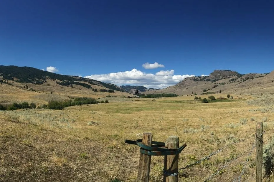
Location & Continent
Continent: North America
Country: United States (Oregon, Idaho, Nevada, Utah, California)
Coordinates: 43°N, 117°W
Northern Basin and Range – Map & Street View
Physical Features
Area: A broad EPA Level III ecoregion spanning large portions of SE Oregon, S Idaho, N Nevada and smaller parts of NW Utah and NE California (not a single, bounded “desert” but a mosaic of basins, ranges and playas)
Relief & Landforms: Dissected lava plains, rolling hills, alluvial fans, internally drained basins (playas) alternating with fault-block mountain ranges; classic Basin-and-Range topography
Elevation: ~1,200–3,300 m in mountains; basins commonly 1,200–1,700 m above sea level
Climate & Precipitation
Temperature: Hot, dry summers (valley highs often 32–38 °C; hotter in heatwaves); cold winters with frequent hard freezes at elevation
Precipitation: Low overall and strongly elevation-dependent—~150–300 mm annually on many basin floors, rising to 750–1,000+ mm as snow on high peaks (e.g., Steens Mountain); western subregions see a winter peak, elsewhere late-spring peaks are common
Type: Cold desert / semi-arid steppe with strong rain-shadow effects and high potential evaporation
Ecological Features
Ecozone: Nearctic
Biome: Temperate cold desert and sagebrush steppe
Ecoregions (Level IV examples): Dissected High Lava Plateau, Pluvial Lake Basins, High Desert Wetlands, Owyhee Uplands & Canyons, High Lava Plains, Barren Playas
Flora & Fauna
Flora: Dominated by big sagebrush (Artemisia tridentata—Wyoming, basin, and mountain forms), rabbitbrush, greasewood and shadscale on alkaline flats; bunchgrasses such as bluebunch wheatgrass, Idaho fescue, Thurber’s needlegrass; scattered western/Utah juniper on rocky uplands; higher zones with Douglas-fir, limber/whitebark pine and quaking aspen
Fauna: Pronghorn, mule deer, pygmy rabbit, greater sage-grouse, sage thrasher, ferruginous hawk, golden eagle, burrowing owl, kit fox, coyote; native fishes (e.g., Lahontan & Warner suckers) in isolated lake/stream systems; reptiles common on warm basin floors
Geology & Notable Features
Geology: Part of the Basin and Range Province—crustal extension produced north–south fault-block mountains and internally drained basins; widespread Miocene flood basalts and younger volcanic cones; Pleistocene pluvial lakes left broad shorelines, beaches, dunes and salt flats
Notable Features: Alvord Desert and Lake Abert playas, Summer Lake and Malheur wetlands; Steens Mountain & Abert Rim fault scarp; Hart Mountain National Antelope Refuge; Owyhee Canyonlands; extensive BLM rangelands; strong geothermal and wind resources under careful siting to protect sagebrush habitats
Introduction
The Northern Basin and Range is a striking geomorphological region of the United States, primarily located in parts of Nevada, Utah, and Idaho. This area is characterized by its unique landscape of alternating mountain ranges and valleys, showcasing a stunning variety of ecosystems and wildlife. Understanding this extraordinary desert region requires an exploration of its geography, climate, flora, and fauna.
Geography
The Northern Basin and Range spans approximately 180,000 square miles, featuring distinct topographical characteristics. This region is known for its elongated mountain ranges, such as the Sierra Nevada and the Wasatch Mountains, interspersed with arid basins and valleys. The terrain features a variety of elevations, with some mountain peaks soaring over 12,000 feet.
Key Geographical Features
| Feature | Description | Location |
|---|---|---|
| Great Basin | Largest desert in North America, characterized by numerous salt flats. | Nevada |
| Ruby Mountains | A mountain range known for its wilderness and outdoor recreation. | Nevada |
| Bear River Range | Offers unique rock formations and is a popular hiking destination. | Utah |
Climate
The climate of the Northern Basin and Range is primarily a high desert climate, which signifies hot summers and cold winters. Precipitation within the region is low, averaging between 5 to 15 inches annually, with much of it falling as snow in higher elevations during winter months.
Temperature Variations
Temperature in the Northern Basin and Range can vary significantly due to altitude:
- Summer: Average highs can reach up to 100°F in basin areas.
- Winter: Mountain areas can see lows of -10°F.
Flora and Fauna
The Northern Basin and Range’s diverse ecosystems support a wide variety of flora and fauna adapted to its arid climate. Desert vegetation is predominant, featuring sagebrush, juniper trees, and various cacti species. In contrast, the higher elevations boast coniferous forests dominated by ponderosa pine and white fir.
Wildlife
Common wildlife inhabiting the region includes:
- Coyotes – Highly adaptable predators.
- Desert tortoises – A threatened species often found in the low desert.
- Mountain goats – Typically found at higher elevations.
Human Impact and Conservation
Despite its rugged landscape, the Northern Basin and Range has been impacted by human activities including mining, agriculture, and urban development. Conservation efforts are crucial to protecting the delicate ecosystems and wildlife native to this region.
Protected Areas
Several national parks and protected areas exist within the Northern Basin and Range, including:
- Great Basin National Park – Notable for its unique geological features and biodiversity.
- Ruby Mountains Wilderness – Offers stunning scenery and recreational opportunities.
Conclusion
In summary, the Northern Basin and Range is a fascinating and ecologically rich region that offers insights into the geological and biological diversity of deserts. Its unique geographical features, dramatic climate variations, and intricate ecosystems highlight the complexity of this arid landscape. Ongoing conservation efforts will be vital to ensuring the preservation of this remarkable region for future generations.
References
Government / Official Sources
US EPA — Level III Ecoregions of North America (Northern Basin and Range overview)
U.S. National Park Service — The Basin and Range Province (geomorphic context)
USGS — Land-cover change in the Northern Basin and Range Ecoregion
State / University / Conservation Sources
Oregon Conservation Strategy — Northern Basin & Range (climate, elevation, habitats)
bplant.org — Northern Basin and Range (precipitation ranges, flora overview)
WAFWA — Sagebrush Conservation Strategy (sagebrush-dependent wildlife)


