
Location & Continent
Continent: North America
Country: United States
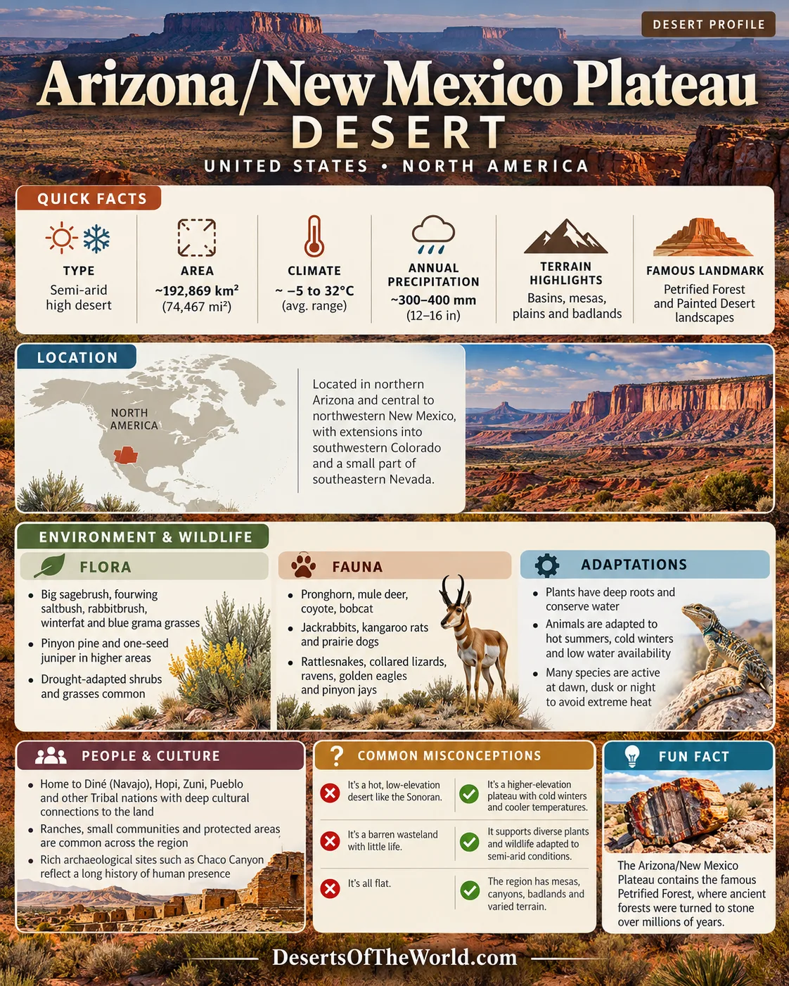
Primary Extent: Northern Arizona and central to northwestern New Mexico, with extensions into southwestern Colorado and a small part of southeastern Nevada
Coordinates: ~35°N, 109°W
Arizona/New Mexico Plateau – Map & Street View
Physical Features
Area: ~192,869 km² (74,467 mi²) for the Arizona/New Mexico Plateau Level III ecoregion
Landscape: Broad basins, plains, mesas, tablelands, badlands, and deeply cut drainage systems
Elevation: Much of the region lies roughly 1,200–2,400 m above sea level, with higher terrain along adjoining mountain areas
Relief: From nearly level plains and mesa tops to more than 300 m along tableland slopes
Climate & Precipitation
Temperature: Hot summers on lower open plains and cold winters at higher elevations; large daily temperature changes are common
Precipitation: Generally ~300–400 mm annually (12–16 in), with moisture from winter storm systems and the summer monsoon
Ecological Features
Ecozone: Nearctic
Biome: Semi-arid grassland, desert and shrub steppe, and pinyon–juniper woodland
Ecoregion: Arizona/New Mexico Plateau (EPA Level III), occupying much of the southern Colorado Plateau transition zone
Flora & Fauna
Flora: Big sagebrush (Artemisia tridentata), fourwing saltbush (Atriplex canescens), rabbitbrush (Ericameria and related genera), winterfat, blue grama and other dryland grasses; two-needle pinyon (Pinus edulis) and one-seed juniper (Juniperus monosperma) occur in woodland zones
Fauna: Pronghorn, mule deer, coyote, bobcat, black-tailed jackrabbit, desert cottontail, kangaroo rats, prairie dogs, rattlesnakes, collared lizards, horned lizards, ravens, golden eagles, ferruginous hawks, and pinyon jays
Geology & Notable Features
Geology: Sedimentary rocks ranging from Triassic through Cretaceous age form mesas, cliffs, badlands, and broad tablelands. Volcanic rocks and lava fields occur locally, while windblown sediment covers parts of the plateau surface.
Notable Features: Painted Desert and Petrified Forest landscapes, the San Juan Basin and Chaco Canyon, Little Colorado River country, sandstone mesas and canyons, and extensive Diné (Navajo), Hopi, Zuni, Pueblo, and other Tribal cultural landscapes
Arizona/New Mexico Plateau: High-Desert Ecoregion
The Arizona/New Mexico Plateau is a large semi-arid ecoregion occupying much of the southern half of the Colorado Plateau. It forms a transition between the higher-relief Colorado Plateaus to the north, semiarid grasslands farther east, mountain ecoregions to the northeast and southwest, and hotter desert regions toward the south and west.
Vegetation changes with elevation, soil, and available moisture. Sagebrush, rabbitbrush, saltbush, winterfat, blue grama, and other grasses dominate many open areas, while pinyon and juniper become more common on higher mesas and slopes. Biological soil crusts occur on undisturbed ground in parts of the region and help stabilize dry soils.
Sedimentary formations account for many of the plateau’s mesas, badlands, and canyon walls. The Painted Desert exposes colorful sedimentary layers, while areas of volcanic rock record younger episodes of lava flow and cinder-cone activity. Drainages associated with the Little Colorado, San Juan, and other river systems cut through these formations and expose long sequences of rock.
The region is also a living cultural landscape. Diné (Navajo), Hopi, Zuni, Pueblo, and other Indigenous communities maintain present-day ties to lands within and around the plateau. Chaco Canyon preserves major Ancestral Puebloan architecture and road systems, while many other archaeological and ceremonial places remain culturally connected to Tribal communities today.
Visiting the Plateau
Conditions vary considerably across the plateau because of elevation, season, and distance from developed areas. Summer heat, winter freezes, strong winds, thunderstorms, and flash flooding can all occur. Visitors should carry adequate water, avoid disturbing biological soil crusts and archaeological material, and follow access requirements on National Park Service, Bureau of Land Management, state, and Tribal lands. Some culturally sensitive locations are closed or require permission from the relevant Tribal authority.
Introduction
The Arizona/New Mexico Plateau is a semi-arid highland ecoregion of the American Southwest and southern Colorado Plateau. Its broad plains, mesas, basins, badlands, and sandstone canyons are bordered by higher mountain regions and lower, hotter deserts. The ecoregion covers about 192,869 km² (74,467 mi²) across northern Arizona, central and northwestern New Mexico, southwestern Colorado, and a small section of southeastern Nevada.
Geography
The Arizona/New Mexico Plateau consists mainly of broad tablelands, basins, plains, mesas, and dissected canyon country. It occupies a large part of the southern Colorado Plateau but is not identical to the entire Colorado Plateau physiographic province.
Several geographic characteristics define the region:
- Extensive plains and mesa surfaces separated by escarpments, washes, and canyons
- The San Juan Basin across northwestern New Mexico and adjoining areas
- Badland landscapes associated with the Painted Desert and nearby sedimentary formations
- Drainage systems connected to the Little Colorado River, San Juan River, and numerous intermittent streams
- Dry uplands transitioning into pinyon–juniper woodland toward higher elevations
The Arizona/New Mexico Plateau is bordered by other ecological regions with different elevations and climates. Mountainous terrain occurs along parts of its northeastern and southwestern margins, while lower and hotter desert environments lie farther south and west.
Plateau Features
| Feature | Description | Regional Setting |
|---|---|---|
| Painted Desert | Badlands developed in colorful sedimentary formations, especially within and around Petrified Forest National Park. | Northeastern Arizona |
| San Juan Basin | A broad structural basin containing mesas, badlands, dry grasslands, shrublands, and major archaeological landscapes. | Northwestern New Mexico and adjoining states |
| Chaco Canyon | Sandstone canyon and mesa terrain containing major Ancestral Puebloan great houses and associated archaeological sites. | Northwestern New Mexico |
| Little Colorado River Country | Plateaus, badlands, washes, and canyon systems shaped by the Little Colorado River and its tributaries. | Northern and northeastern Arizona |
Climate
The Arizona/New Mexico Plateau has a semi-arid to arid continental climate. Elevation produces large local differences in temperature, while low humidity contributes to wide day-to-night temperature ranges.
- Summer: Lower and exposed areas can become hot, while higher mesas remain cooler. Afternoon thunderstorms occur during the summer monsoon.
- Winter: Freezing temperatures are common, particularly at night and at higher elevations. Snow occurs in parts of the region.
- Annual precipitation: Much of the ecoregion receives roughly 300–400 mm (12–16 in) each year, although totals vary with elevation and location.
- Seasonality: Moisture arrives through both winter storm systems and summer thunderstorms, with long dry periods possible between events.
Rainfall can be highly localized. Summer storms may produce heavy short-duration precipitation and flash flooding even when nearby areas remain dry.
Flora and Fauna
Vegetation across the plateau is dominated by grassland, shrub steppe, desert scrub, and pinyon–juniper woodland. Plant communities change with elevation, soil depth, salinity, and available moisture.
- Shrubs: Big sagebrush, rabbitbrush, fourwing saltbush, winterfat, and other drought-tolerant shrubs occur across open uplands and basins.
- Grasses: Blue grama, galleta grass, western wheatgrass, and other native grasses are common in semi-arid grasslands.
- Woodlands: Two-needle pinyon and one-seed juniper form open woodland on many mesas and higher slopes.
- Mammals: Pronghorn, mule deer, coyotes, bobcats, jackrabbits, cottontails, kangaroo rats, and prairie dogs occur in suitable habitats.
- Birds: Golden eagles, ferruginous hawks, ravens, pinyon jays, and several grassland and shrubland species use the region.
- Reptiles: Rattlesnakes, collared lizards, horned lizards, and other reptiles occupy rocky, sandy, and grassland environments.
Saguaro cactus is characteristic of the lower and warmer Sonoran Desert rather than the Arizona/New Mexico Plateau and is therefore not representative of this ecoregion.
Indigenous and Cultural Landscape
The Arizona/New Mexico Plateau overlaps lands with long-standing and present-day connections to Diné (Navajo), Hopi, Zuni, Pueblo, and other Indigenous peoples. Tribal communities are part of the modern region as well as its archaeological record.
- Land Use: Farming, livestock raising, gathering, and other land-based practices vary among communities and environments across the plateau.
- Archaeological Sites: Chaco Canyon, pueblos, roads, rock art, field systems, and other remains document long histories of settlement and movement.
- Living Cultural Sites: Many mountains, springs, archaeological locations, and landscape features retain ceremonial or community importance and may have specific access rules.
- Arts: Pottery, weaving, jewelry, carving, and other artistic traditions continue within communities across the wider region.
Tribal nations should not be treated only as part of the plateau’s past. Their governments, communities, languages, land management practices, and cultural traditions remain part of the region today.
Conclusion
The Arizona/New Mexico Plateau is a large semi-arid transition zone within the southern Colorado Plateau. Broad tablelands, basins, sedimentary badlands, sandstone canyons, grasslands, shrublands, and pinyon–juniper woodland define much of its terrain. Winter storms and summer monsoon rainfall support ecosystems adapted to limited and variable moisture.
The plateau also contains major cultural landscapes, including Chaco Canyon and extensive lands connected to Diné, Hopi, Zuni, Pueblo, and other Indigenous communities. Its geology, dryland ecology, and present-day Tribal landscapes distinguish it from both the lower deserts to the south and west and the higher mountain regions around its margins.
References
Government / Official Sources
- U.S. Geological Survey — Arizona/New Mexico Plateau Ecoregion
- U.S. Environmental Protection Agency — Ecoregions of North America
- National Park Service — Petrified Forest National Park
- National Park Service — Chaco Culture National Historical Park
Climate & Regional Sources
- National Park Service — Chaco Culture Natural Resources and Climate
- National Park Service — Petrified Forest Vegetation Inventory
- National Park Service — Chaco Culture Vegetation Inventory
- NOAA — Climate Data Online