
Current Access – October 2026
A temporary Bureau of Land Management closure remains in effect on part of Black Rock Desert Playa for the 2026 Burning Man event cleanup period.
- Temporary closure: About 10,185 acres, less than 3% of the playa, are closed to unauthorized recreational use from July 30 through October 10, 2026.
- Open playa: The remainder of Black Rock Desert Playa remains open to dispersed recreational use.
- Through traffic: The East and West Playa Highways remain open for through traffic during the closure.
The temporary restriction is scheduled to end after October 10. Check the BLM closure notice and current Black Rock Field Office information before visiting.
Location & Continent
Continent: North America
Country: United States
State: Nevada
Counties: Washoe, Pershing, Humboldt
Region: Great Basin (high desert of the American West)
Closest Gateway Community: Gerlach
Coordinates (Central Playa Approx.): 40.86°N, 119.18°W
Black Rock Desert – Map & Street View
Physical Features
Landscape Type: Playa (dry lakebed) within a broader basin-and-range desert setting
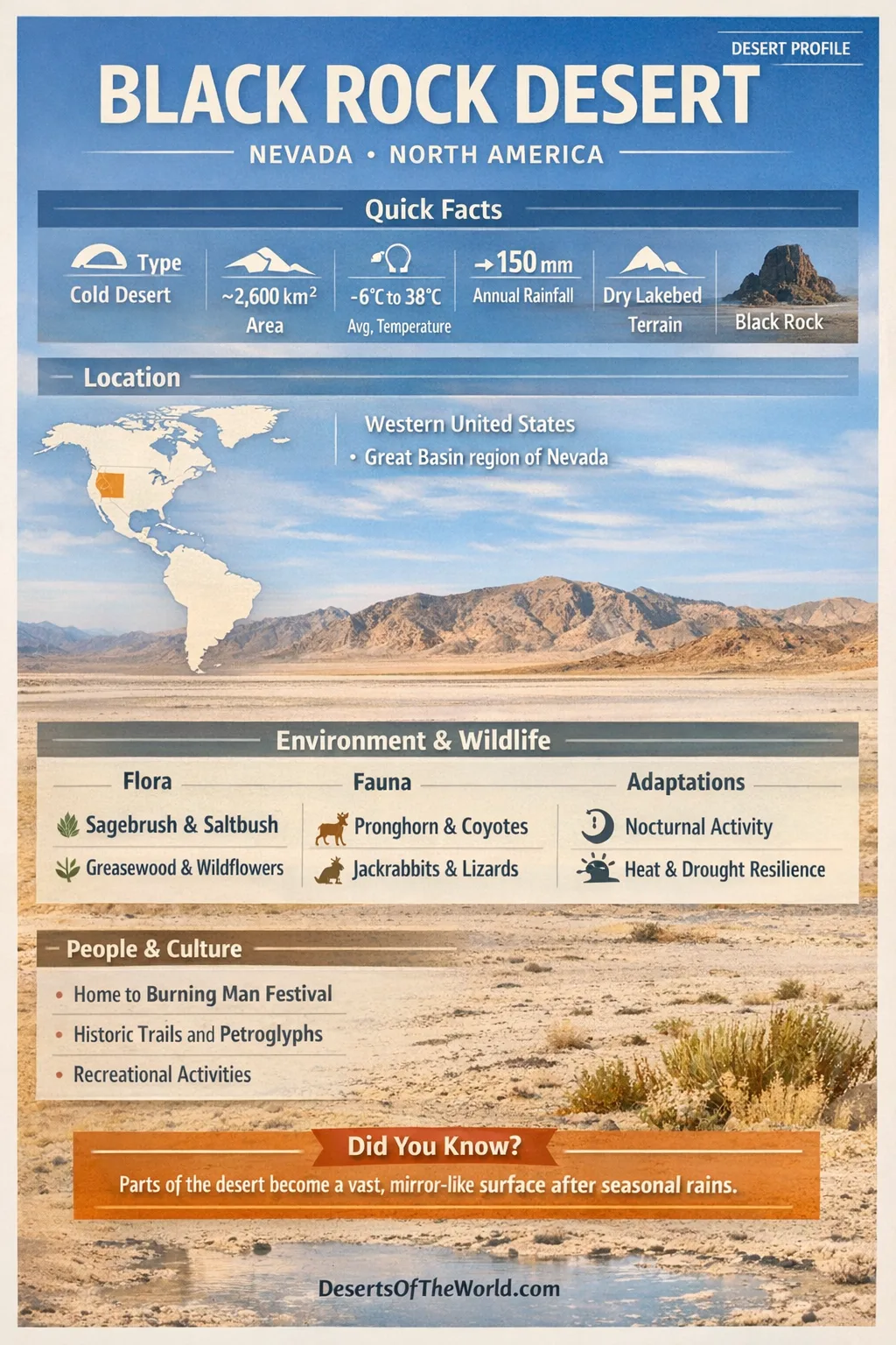
Estimated Area (Wider Desert Basin): ~2,600 km² (about ~1,000 sq mi)
Central Playa: several hundred km² of mostly flat, alkaline clay
Typical Playa Elevation: ~1,190 m (about ~3,900 ft) above sea level
Surrounding Relief: ranges and highlands rise well above the basin floor, shaping wind and drainage patterns
Signature Surface: pale alkali crust, polygon cracks, and hardpan that can become firm and smooth when dry
Climate & Precipitation
The Black Rock Desert sits in Nevada’s high-desert belt, where the air is dry and weather can change quickly. Many climate maps classify it as a cold desert (often described as BWk), shaped by elevation and distance from the ocean.
Summer: long days with hot afternoons, commonly 32–38°C (90–100°F), paired with much cooler nights.
Winter: cold conditions with nighttime temperatures that can drop below freezing; the basin also occasionally receives snow.
Annual Precipitation (General Range): ~100–200 mm (about 4–8 inches) in nearby low-elevation areas, varying by storm track and year.
Wind: breezes and stronger gusts can lift fine playa sediment and create dusty conditions.
Ecological Setting
The central Black Rock Playa has little persistent vegetation because its salty, alkaline surface alternates between waterlogged and extremely dry conditions. More diverse Great Basin plant communities occur around the playa margins and surrounding uplands.
Ecozone: Great Basin Desert (high-elevation desert and shrublands)
Biome: Deserts and xeric shrublands
Playa Ecology: seasonal wet-dry cycles that favor short-lived, highly adapted organisms and microbial films
Flora & Fauna
Away from the central playa, the landscape transitions into shrub steppe. Plants in these dry environments commonly have small leaves, waxy surfaces, extensive roots or other adaptations that limit water loss.
Common Plant Types Around the Playa:
- Sagebrush and other aromatic shrubs that characterize much of the Great Basin
- Saltbush and greasewood in more saline soils
- Seasonal wildflowers following favorable moisture conditions
Many animals reduce exposure to daytime heat by moving during cooler morning, evening or nighttime periods.
Animals Often Associated With the Region:
- Pronghorn and mule deer in the wider basin-and-range landscape
- Coyotes, jackrabbits, and small mammals using open desert terrain
- Reptiles and insects adapted to heat and dry air
- Birdlife that can increase seasonally when nearby wetlands, springs and seeps hold water
After sufficient rain, shallow water can temporarily cover portions of the playa and alter conditions for birds, insects and microorganisms.
Geology & Notable Features
The geology of the Black Rock Desert is closely connected with the former Lake Lahontan system. During the late Pleistocene, this large pluvial lake covered extensive parts of northwestern Nevada. As the lake contracted, fine sediments and salts accumulated in basins that now include Black Rock Playa.
Key Geological Themes:
- Pluvial-lake legacy: fine-grained clays and salts deposited during wetter climatic periods
- Basin-and-range motion: crustal extension producing alternating basins and mountain blocks
- Volcanic influence: regional volcanism contributing dark rock outcrops and varied soils
Notable Features in and Around the Black Rock Desert:
- Black Rock itself: a dark rocky landmark rising above the pale basin and giving the desert its name
- High Rock Canyon area nearby: volcanic cliffs and canyons within the wider conservation landscape
- Hot springs and geothermal areas associated with the region’s active geologic setting
The contrast between pale playa sediments, darker volcanic rock and surrounding mountain ranges makes the region’s geologic structure visible across the landscape.
Introduction to the Black Rock Desert
The Black Rock Desert in northwestern Nevada is best known for Black Rock Playa, a broad and unusually level dry lakebed surrounded by Great Basin mountain ranges.
Unlike deserts dominated by dune systems, the central Black Rock landscape is defined by an expansive clay playa. When dry, the surface develops polygonal cracks and firm hardpan. After rain or snowmelt, shallow water and mud can temporarily cover parts of the playa, making surface conditions unsuitable for vehicle travel.
Playa Dynamics and Seasonal Change
A playa is a closed desert basin where water collects temporarily and evaporates rather than draining to the ocean. In the Black Rock Desert, water may arrive from winter storms, snowmelt or runoff from surrounding uplands. It spreads across low areas and later evaporates, leaving alkaline clay and salts behind.
The most important practical detail is that flat does not mean stable. The surface can change from firm and dry to soft mud after precipitation. Repeated wetting, drying and wind movement also reshape the playa crust and redistribute fine sediment.
Water, Salts, and the Desert’s Chemistry
Water entering Black Rock Playa carries dissolved minerals and fine sediment. Because the basin has no external drainage, evaporation concentrates salts and helps create the playa’s alkaline conditions. This chemistry limits persistent vegetation in the playa center, while salt-tolerant shrubs occur around less extreme margins.
The mineral crust varies with moisture, sediment and evaporation. When completely dry, fine surface particles can be lifted by strong winds and produce dusty conditions across the playa.
Land Management and Protected Landscapes
Much of the Black Rock Desert and surrounding landscape is public land managed by the Bureau of Land Management. The wider region includes the Black Rock Desert–High Rock Canyon Emigrant Trails National Conservation Area, which protects desert ecosystems, geologic features and historic emigrant routes across the Great Basin.
The conservation area includes more than the playa itself. Canyons, volcanic uplands, springs, basins and historic travel corridors form part of the wider protected landscape.
Human Presence and Cultural Footprints
People have traveled through this part of Nevada for centuries, using water sources, passes and natural corridors through the basin-and-range landscape. Historic emigrant routes crossed portions of the region during nineteenth-century westward migration.
In recent decades, Black Rock Playa has also become the site of large temporary gatherings. The best known is Burning Man, whose event operations require temporary BLM closures and restrictions on portions of the playa each year.
What Makes Black Rock Desert Stand Out Among World Deserts
Many deserts are dominated by dunes, gravel plains or exposed rock. The Black Rock Desert is distinguished by its large, flat playa and its origin within a former Pleistocene lake basin.
Its geology provides a clear example of how desert landscapes can develop through changing climate, closed-basin drainage, evaporation and sediment accumulation rather than through dune formation alone.
Black Rock Desert Data Table
| Category | Details |
|---|---|
| Desert Type | Cold high desert with a major playa (dry lakebed) |
| Core Surface | Alkaline clay hardpan, seasonal shallow water, salt crust |
| Elevation | Playa around ~1,190 m (~3,900 ft) |
| Rainfall | Low annual totals, often ~100–200 mm (4–8 in) in the basin region |
| Key Formation Story | Remnant basin of a Pleistocene pluvial lake system (Lake Lahontan legacy) |
| Typical Vegetation | Edge-zone sagebrush, saltbush, greasewood; sparse to none in central playa |
References
Bureau of Land Management – 2026 Temporary Closures at Black Rock Desert Playa
Bureau of Land Management – 2026 Black Rock Closure Map
Bureau of Land Management – Black Rock Desert–High Rock Canyon Emigrant Trails NCA
U.S. Geological Survey – Lake Lahontan (Background and Geologic Context)
National Park Service – Lake Lahontan Overview Article
University of Nevada, Reno Extension – Great Basin/High Desert Ecology Resource
National Weather Service – Regional Climate and Weather Data (Nevada)