Salt flats are flat desert surfaces where water has left behind salt and other minerals after repeated cycles of flooding, evaporation, and drying. They may look empty from a distance, yet they record lake history, climate change, groundwater movement, mineral chemistry, wind action, and desert drainage in one pale surface. Some are hard enough to drive across in dry months. Others hide soft mud below a thin crust. The difference matters.
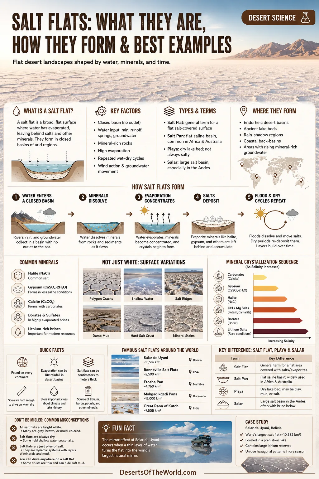
What Is a Salt Flat?
A salt flat is a natural landform where salt-rich minerals collect on a low, flat surface. Most salt flats form in dry regions where water enters a basin but has no easy way out. The water may arrive from rainfall, mountain runoff, springs, groundwater, or old lakes. When that water evaporates, dissolved minerals stay behind.
Over time, the basin floor becomes coated with evaporite minerals. The most familiar one is halite, the mineral form of common salt. Gypsum, calcite, borates, sulfates, carbonates, and lithium-bearing brines may also occur, depending on local geology.
| Feature | Salt Flat Meaning |
|---|---|
| Landform Type | Flat evaporite surface in a dry basin, playa, salt pan, or salar |
| Main Process | Water dissolves minerals, collects in a closed basin, then evaporates |
| Common Minerals | Halite, gypsum, calcite, borates, sulfates, carbonates |
| Usual Climate | Arid or semi-arid, where evaporation often exceeds rainfall |
| Surface Look | White crust, polygon cracks, damp mud, shallow seasonal water, or rough salt ridges |
| Desert Connection | Many salt flats sit inside desert basins, dry lake beds, or rain-shadow landscapes |
Salt Flat, Salt Pan, Playa, and Salar: The Difference
People often use these words as if they mean the same thing. They overlap, but each word carries a slightly different meaning.
Salt Flat
A salt flat is a broad, flat surface with visible salt or other evaporite minerals. It may be dry, wet, crusted, muddy, bright white, or gray-white depending on season and mineral mix.
Salt Pan
A salt pan usually means a flat basin floor where salts collect after water evaporates. In African and Australian deserts, “pan” is widely used for dry lake beds and saline basins.
Playa
A playa is a dry lake bed in a closed desert basin. Not every playa is bright white with salt. Some are mostly clay, silt, or mud. A playa becomes a salt flat when evaporite minerals dominate the surface.
Salar
Salar is common in Andean regions of South America. It usually refers to a large salt flat or salt basin, often with a thick crust and salty brine below. Salar de Uyuni in Bolivia is the best-known example.
| Term | Best Use | Typical Example |
|---|---|---|
| Salt Flat | General term for a flat salt-covered surface | Bonneville Salt Flats, Utah |
| Salt Pan | Flat saline basin, often used in Africa and Australia | Etosha Pan, Namibia |
| Playa | Dry lake bed in a closed basin | Death Valley playas, California |
| Salar | Large salt basin, especially in the Andes | Salar de Uyuni, Bolivia |
How Salt Flats Form
Salt flats begin with water, not salt. That may sound backwards, but it is the heart of the process. A desert basin needs a water source, a closed drainage setting, mineral-bearing rocks, and enough evaporation to leave dissolved material behind.
1. Water Enters a Closed Basin
Many salt flats sit in endorheic basins. These are drainage basins with no outlet to the sea. Rivers, streams, springs, floodwater, and groundwater may enter the basin, but the water cannot flow onward through a normal river system.
Instead, it collects at the lowest point. In wetter periods, that low point may become a lake. In drier periods, it shrinks, breaks into ponds, or disappears from the surface.
2. Water Dissolves Minerals from Rock and Sediment
Water is never just water in a landscape. As it moves through mountains, volcanic rocks, limestone, sandstone, ancient lake beds, and desert soils, it picks up dissolved ions. Sodium, chloride, calcium, magnesium, sulfate, carbonate, potassium, boron, and other elements can travel with it.
In a river with an outlet, these dissolved minerals keep moving downstream. In a closed desert basin, they stay trapped.
3. Evaporation Removes Water but Leaves Minerals
Dry air, strong sun, and wind pull water back into the atmosphere. The minerals do not evaporate with it. As the water becomes more concentrated, minerals begin to crystallize.
Different minerals appear at different stages. Carbonates may form before gypsum. Halite forms when brine becomes very salty. In some basins, borates, potash minerals, or lithium-rich brines may develop under the crust.
4. Flooding and Drying Repeat
A salt flat is not made in one dry season. It grows through repeated wet-and-dry cycles. Floods dissolve old salt. Summer heat or dry-season air redeposits new salt. Wind adds dust. Groundwater rises through the crust and brings more dissolved minerals upward.
Layer by layer, a white or pale mineral surface forms. Thin in some places, thick in others.
5. The Surface Becomes Smooth, Cracked, or Polygonal
Salt flat surfaces can look smooth after fresh flooding and evaporation. Later, crystals grow, shrink, push, crack, and lift. That creates crust ridges, rough salt plates, and the famous polygon patterns seen on many playas.
The pattern is not decoration. It is the surface expression of moisture, salt movement, crystal growth, and underground brine behavior.
Why Salt Flats Are So Flat
Salt flats are among the flattest natural surfaces on Earth because they form at the bottom of low basins where fine sediment and dissolved minerals settle evenly. Shallow water helps level the surface, a bit like a thin coat of plaster spreading across a floor.
When floodwater covers a basin, suspended clay and silt can settle. When the water evaporates, salts crystallize over that level surface. Repeated cycles smooth out small bumps. In very large salt flats, the flatness can be so even that the horizon seems unusually clean and low.
Not every part is perfectly flat, though. Edges often grade into mud, dunes, marshy ground, alluvial fans, or rough evaporite crust. The center is usually the flattest part because it is the lowest and most often flooded.
Why Salt Flats Are White
Many salt flats look white because halite and other evaporite minerals reflect sunlight well. Fresh salt crystals can make a basin look almost snow-covered, even in hot desert air.
The color changes with moisture and sediment. A dry halite crust can look bright white. A damp surface may appear gray, cream, or glassy. Windblown dust can dull the surface. Thin floodwater can turn the flat into a mirror, especially where the crust beneath is smooth and pale.
Why Some Salt Flats Form Mirror Surfaces
The mirror effect appears when shallow water spreads across a very flat salt crust. The water layer must be thin and calm. Too much wind breaks the reflection. Too much water hides the white crust and behaves more like a lake.
Salar de Uyuni is famous for this because the surface is broad, level, and reflective after seasonal rain. The effect is simple: a thin sheet of water lies over a flat, light-colored crust. The sky has nowhere to break.
It lasts only while conditions stay right. Heat and wind can remove the water quickly. One day, mirror. Soon after, salt again.
Inside a Salt Flat: Crust, Brine, Mud, and Older Lake Beds
A salt flat is not just a white skin on the ground. Beneath the surface, layers may include hard crust, damp salt, clay-rich sediment, saline groundwater, older lake deposits, and buried evaporites.
Salt Crust
The crust is the visible surface. It may be thin and fragile near the edges or thick and hard toward the center. Bonneville Salt Flats, for example, has areas where the salt crust is much thicker near the center and much thinner toward the margins.
Brine
Brine is very salty water held within pores and spaces below the surface. In some salars, brine contains lithium, potassium, boron, magnesium, and other dissolved materials. This is why some salt flats are studied not only as landforms but also as mineral systems.
Clay and Lake Sediment
Many salt flats formed from old lakes. Their basins may contain layers of clay, silt, volcanic ash, organic traces, shoreline deposits, and chemical minerals. These layers help geologists read past climate conditions.
Groundwater Flow
Groundwater can move through and below a salt flat. It may dissolve salt in one place and help redeposit it in another. That is why salt flats can change even when the surface looks still.
Salt Flats and Desert Climate
Salt flats are strongly tied to desert and semi-desert climates because they need high evaporation. Rain is not absent, but it usually cannot keep up with drying.
Many salt flats form in rain shadows, high plateaus, inland basins, and desert valleys. Mountains often matter as much as the basin itself. They provide runoff, dissolved minerals, and closed topography.
Three conditions appear again and again:
- Limited drainage: water collects instead of flowing to the sea.
- High evaporation: dry air removes water faster than it is replaced.
- Mineral supply: surrounding rocks and sediments feed dissolved salts into the basin.
Main Types of Salt Flats
Ancient Lake Salt Flats
These form where old lakes dried out after climate shifted toward drier conditions. Bonneville Salt Flats and Salar de Uyuni both belong to this broad story. Their present surfaces are tied to much larger water bodies that existed in wetter periods.
Seasonal Playa Salt Flats
Some playas flood during storms or wet seasons, then dry again. Their salt crust may dissolve and reform every year or every few years. Badwater Basin in Death Valley is a strong example of a changing salt surface shaped by floodwater, heat, and crystal growth.
Coastal Salt Flats and Sabkhas
Some saline flats form near coasts, lagoons, tidal margins, or low coastal deserts. These are often called sabkhas in North Africa and the Arabian Peninsula. They can flood from seawater, storm surge, groundwater, or rare rain.
High-Altitude Salars
High Andean salars form in interior basins between mountains and volcanic plateaus. They often combine old lake history, volcanic mineral supply, strong sun, dry air, and cold nights. Several contain brines rich in lithium and other dissolved elements.
Best Examples of Salt Flats Around the World
The best-known salt flats are not all the same. Some are famous for size. Some for speed records. Some for wildlife, seasonal water, ancient lake history, or mineral study.
| Salt Flat | Location | Why It Matters |
|---|---|---|
| Salar de Uyuni | Bolivia | Largest salt flat on Earth; famous for mirror surfaces, halite crust, and lithium-bearing brines |
| Bonneville Salt Flats | Utah, United States | Remnant of ancient Lake Bonneville; known for broad, hard salt crust and land-speed history |
| Badwater Basin | California, United States | Lowest point in North America; active salt crust, seasonal flooding, and polygon patterns |
| Etosha Pan | Namibia | Large salt pan linked with seasonal water and wildlife habitat around its margins |
| Makgadikgadi Pans | Botswana | Vast pan system left by an ancient lake in the Kalahari region |
| Salar de Atacama | Chile | Andean salar with salt crust, brines, lagoons, and desert-margin ecosystems |
| Chott el Djerid | Tunisia | Large North African salt lake and pan system with seasonal water and dry salt crusts |
| Lake Eyre / Kati Thanda Basin | Australia | Large inland salt lake basin that shifts between dry salt surface and rare floodwater |
Salar de Uyuni, Bolivia
Salar de Uyuni sits on the Bolivian Altiplano, a high interior plateau in the Andes. It is widely described as the world’s largest salt flat, covering roughly 10,000 square kilometers. Its salt crust formed after prehistoric lakes dried, leaving behind layers of halite and lake sediment.
The surface is famous for two very different moods. In dry periods, the crust often breaks into polygon patterns. During wet periods, shallow water can form a mirror-like surface across wide areas. Beneath parts of the salar, brines contain lithium and other dissolved minerals.
Bonneville Salt Flats, United States
The Bonneville Salt Flats lie in northwestern Utah, in the Great Salt Lake Desert. They are a remnant of ancient Lake Bonneville, a large Ice Age lake that once covered much of western Utah. As the lake shrank, evaporite minerals remained on the basin floor.
The Bureau of Land Management describes the central crust as much thicker in places than the edges, where it can taper to very thin salt. The surface changes through seasonal flooding, dissolution, drying, and redeposition. It is not a frozen landscape. It moves, chemically.
Badwater Basin, Death Valley, United States
Badwater Basin is the lowest point in North America, about 282 feet below sea level. The salt flats cover a large area on the Death Valley floor and contain mostly sodium chloride, along with minerals such as calcite, gypsum, and borax.
This is an active salt flat. Rainstorms can create temporary lakes. Floodwater dissolves salts, then evaporation leaves fresh crystals behind. That cycle helps form rough salt surfaces, crust ridges, and polygon shapes.
Etosha Pan, Namibia
Etosha Pan is a large salt pan in northern Namibia. For much of the year it appears dry and pale, but seasonal water can gather across parts of the pan. Around the edges, waterholes and grasslands support wildlife, making the pan part of a wider desert-savanna system.
Its value is not only visual. Etosha shows how a salt pan can be both stark and ecologically connected. The pan itself may seem bare, while the margins carry much of the seasonal life.
Makgadikgadi Pans, Botswana
The Makgadikgadi Pans are among the largest salt pan systems in the world. They are remnants of a former lake system in the Kalahari region. Today, wide pale pans, dry grassland, islands of vegetation, and seasonal water create a changing desert basin.
During dry periods, the pans can look almost empty. After rain, shallow water can alter the surface and draw animals to nearby grazing areas.
Salar de Atacama, Chile
Salar de Atacama lies in northern Chile’s Atacama Desert region. It is a high desert salt basin with a rough halite crust, saline lagoons, brines, and volcanic surroundings. The setting shows how salt flats can form where mountain runoff, volcanic rocks, dry air, and closed drainage meet.
Unlike the clean white image many people associate with salt flats, Salar de Atacama often has rugged crusts and darker tones. Salt flats are not always smooth.
Chott el Djerid, Tunisia
Chott el Djerid is a large salt lake and salt pan system in the Sahara region of Tunisia. Its surface may shift between dry crust, damp patches, and shallow seasonal water. In hot weather, reflected light and distance can create strong mirage effects.
North African chotts show how salt flats can belong to broad arid basin systems, not only bright white tourist landscapes.
Lake Eyre / Kati Thanda, Australia
Kati Thanda–Lake Eyre is a large inland basin in Australia. It is often dry and salt-covered, but rare flood events can bring water over huge areas. The basin then changes color, texture, and ecological role for a time before drying returns.
It is a reminder that salt flats can be dry most years and still be part of a living hydrologic system.
Why Salt Flats Develop Polygon Patterns
Many salt flats show honeycomb-like polygons across the surface. These shapes form as salt, water, mud, and heat interact near the ground surface.
As brine evaporates, salt crystals grow. The crust expands, cracks, lifts, and reorganizes. Moisture can move through cracks and bring more dissolved salt upward. Over time, ridges form around polygon edges. The shapes may be small and tight or broad and open, depending on salt type, moisture, crust thickness, and drying conditions.
Polygon patterns are often most visible in dry periods. After flooding, they may soften, dissolve, or disappear under a new thin layer of salt.
Are Salt Flats Always Dry?
No. Many salt flats are dry only part of the time. Some flood seasonally. Some hold shallow water after rare storms. Some have wet mud beneath a crust that looks dry on top.
This matters for understanding the landform. A salt flat is not simply “a dry place.” It is a place where water arrives, lingers, dissolves minerals, and vanishes again. The dry surface is only one phase of the cycle.
Why Salt Flats Can Be Fragile
Salt flats may look hard and plain, but they can be fragile. Tire tracks can remain visible for a long time in soft or damp areas. Thin crust can break under weight. Edges can be muddy. Seasonal ponds can dissolve and rebuild the surface.
The most stable-looking parts are not always safe or durable. In many salt flats, local land managers mark where vehicles, walking routes, or viewing areas are allowed. Those rules protect both visitors and the crust.
Salt Flats as Natural Climate Records
Salt flats can store clues about older climates. Layers of lake sediment, evaporite minerals, shoreline benches, pollen, volcanic ash, and brine chemistry help researchers reconstruct wet and dry periods.
When a basin contains evidence of a former lake, it tells a simple but useful story: the climate, water supply, or drainage balance was once different. A present-day salt flat may be the floor of a lost lake. Around it, old shorelines on hillsides can mark former water levels.
Salt Flats and Minerals
Salt flats are part of evaporite geology. Their mineral content depends on the rocks around the basin, groundwater chemistry, volcanic influence, lake history, and evaporation rate.
| Mineral or Material | Where It Appears | What It Tells Us |
|---|---|---|
| Halite | White salt crusts and brines | Strong evaporation and sodium-chloride-rich water |
| Gypsum | Crusts, crystals, and mixed evaporite layers | Sulfate-rich water and staged evaporation |
| Calcite | Carbonate-rich layers and crust mixtures | Calcium and carbonate chemistry in basin water |
| Borates | Some desert basins and evaporite deposits | Special basin chemistry, often linked with arid closed basins |
| Lithium-Rich Brine | Some salars below the salt crust | Long-term concentration of dissolved elements in closed basins |
| Clay and Silt | Below and between evaporite layers | Former lake beds, flood events, and basin sedimentation |
Do Plants and Animals Live on Salt Flats?
The bare salt crust usually supports little plant life because salinity is high and water is limited. The margins are different. Around the edges of salt flats, saline wetlands, springs, dunes, shrubs, grasses, microbial mats, and seasonal pools may support life adapted to harsh conditions.
Birds may use nearby saline lagoons. Insects and small organisms may appear after water returns. Salt-tolerant plants can grow where soils are less extreme. The center may seem empty, but the surrounding desert edge often carries the ecological activity.
Salt Flats and Human Use
Salt flats have been used for travel routes, salt collection, scientific study, mineral exploration, racing, photography, and tourism. Their flatness and open views make them memorable, but each use depends on surface condition and local rules.
Bonneville is known for land-speed events on suitable crust. Uyuni is known for travel across a huge salar and for satellite calibration interest because of its broad, flat, reflective surface. Some Andean salars are studied for brines. Badwater Basin is protected inside a national park, where the salt surface is part of a larger desert landscape.
Use changes from place to place. A salt flat inside a protected area is not the same as a managed recreation area or a mineral basin.
How to Recognize a Salt Flat on a Map or Satellite Image
Salt flats often appear as pale, smooth areas at the bottom of closed basins. On satellite images, they may look white, gray, cream, or light tan. Their edges can fade into darker mudflats, alluvial fans, dunes, or shallow water.
Common clues include:
- A low basin with no clear river outlet to the sea
- Pale mineral surfaces in the basin center
- Mountain runoff or dry channels leading inward
- Seasonal lakes or damp patches after rain
- Old shorelines, terraces, or lake-bed sediment around the basin
- Polygon patterns visible in high-resolution imagery
Common Misunderstandings About Salt Flats
“Salt Flats Are Just Dried Oceans”
Some saline basins may have marine influence, especially coastal sabkhas. Many famous inland salt flats did not form from oceans. They formed from lakes, groundwater, runoff, and closed-basin evaporation.
“The Surface Never Changes”
Salt flats change often. Flooding dissolves salt. Drying redeposits it. Wind moves dust. Crystals grow and break. Tracks, crust ridges, and shallow ponds can appear or vanish with season.
“White Means Pure Table Salt”
Halite may dominate, but salt flats often contain mixed evaporites and sediment. Gypsum, calcite, borates, clay, and brines can all be part of the system.
“Dry Means Safe to Cross”
A dry-looking crust can hide wet mud or soft brine below. Edges are often less stable than the center. Marked routes and local guidance matter.
Salt Flats Compared with Other Desert Landforms
| Landform | Main Material | Main Process | How It Differs from a Salt Flat |
|---|---|---|---|
| Sand Dune | Sand grains | Wind transport and deposition | Built by moving sand, not evaporating brine |
| Gravel Desert Pavement | Gravel and rock fragments | Wind removal of finer particles | Rocky surface rather than chemical salt crust |
| Playa Mudflat | Clay, silt, mud | Lake-bed sedimentation and drying | May contain little visible salt |
| Salt Flat | Evaporite minerals and saline sediment | Evaporation in a closed basin | Surface is shaped by mineral precipitation and brine movement |
| Dry Lake Bed | Clay, silt, sand, salts | Former or seasonal lake drying | Can become a salt flat if evaporites dominate |
Why Salt Flats Matter in Desert Geography
Salt flats show how deserts handle water. They prove that dry landscapes can have strong water histories. A basin may be dry now, yet its floor can carry the chemical memory of lakes, floods, springs, and groundwater movement.
They also connect several parts of desert science: geomorphology, hydrology, mineral chemistry, climate history, ecology, and remote sensing. One flat white surface can hold all of that, quietly.
Sources
- Bureau of Land Management: Bonneville Salt Flats Special Recreation Management Area (salt crust thickness, location, surface character, and management context)
- Utah Geological Survey: Bonneville Salt Flats GeoSights (Lake Bonneville history and salt-flat formation)
- National Park Service: Death Valley Salt Flats (crystal growth, flooding, salt crust changes, and surface patterns)
- National Park Service: Badwater Basin (elevation, salt-flat area, and mineral composition)
- NASA Earth Observatory: An Expanse of White in Bolivia (Salar de Uyuni and prehistoric lake evaporation)
- International Union of Geological Sciences: Uyuni Salt Flat (global geoheritage context, halite layers, and Tauca paleolake origin)
- U.S. Geological Survey: Hydrology and Surface Morphology of the Bonneville Salt Flats and Pilot Valley Playa (evaporite zones, halite crust, and playa hydrology)
- U.S. Geological Survey: Playas, Sabkhas, and Saline Lakes (hydrologic links among playas, pans, sabkhas, salinas, saline lakes, and salt flats)