Some roads pass through dry country. Others are shaped by the desert. That difference is what makes the best-known desert drives so memorable. A road beside a dune sea feels different from a road on a salt pan, and both feel different again from a gravel track cut across a stony plateau.
A real desert road is never only about distance. It is about surface, relief, light, drainage, and the way the horizon behaves. On one route, the land is so flat it barely seems to move. On another, a sealed carriageway drops from high mountains into a basin below sea level. Desert roads look simple from far away. Up close, layered they are.
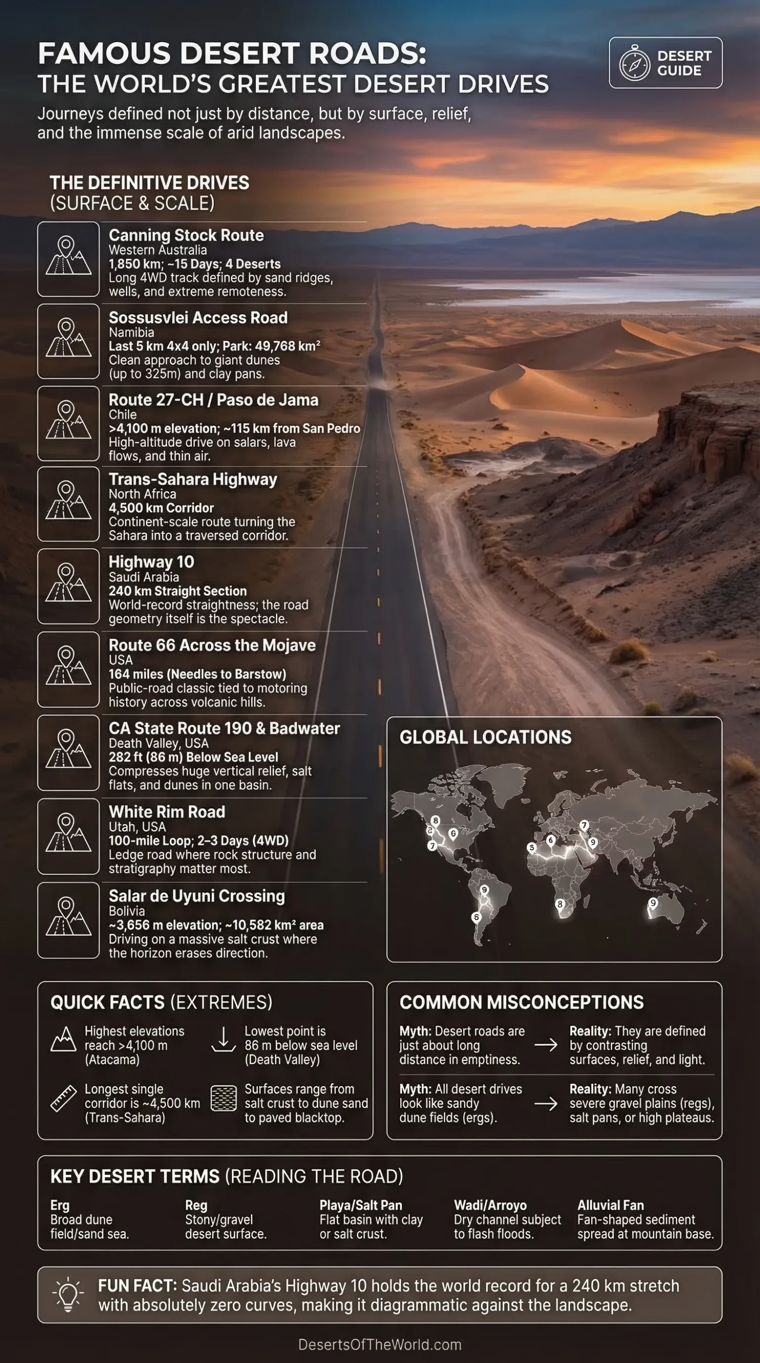
| Road | Desert Setting | Verified Figure | What Makes It Stand Out |
|---|---|---|---|
| Canning Stock Route | Western Australian dune and spinifex deserts | 1,850 km; about 15 days; four deserts | A long 4WD track where wells, sand ridges, and remoteness still define the journey |
| Sossusvlei Access Road | Namib dune sea and clay pan country | Last 5 km for 4×4 vehicles only; park size 49,768 km² | One of the cleanest road approaches to giant dunes anywhere on Earth |
| Route 27-CH / Paso de Jama Corridor | Atacama Desert and high Andean altiplano | Altiplanic lagoons above 4,100 m; about 115 km from San Pedro de Atacama | A desert drive built on altitude, salars, lava flows, and thin air |
| Trans-Sahara Highway | Sahara corridor from North Africa toward West Africa | 4,500 km | A continent-scale road that turns the Sahara into a traversed corridor |
| Highway 10 | Eastern Arabian desert margins | 240 km straight section | World-record straightness, with the road itself as the spectacle |
| Route 66 Across the Mojave | Mojave Desert | 164 miles from Needles across the Mojave to Barstow | A public-road desert classic tied to motoring history |
| California State Route 190 and Badwater Road | Death Valley basin desert | Badwater Basin at 282 ft / 86 m below sea level | A drive that compresses salt flats, dunes, alluvial fans, and huge relief into one basin |
| White Rim Road | High desert canyon country | 100-mile loop; most 4WD trips take 2–3 days | A ledge road where rock structure matters as much as the route itself |
| Salar de Uyuni Crossing | High-altitude salt desert on the Bolivian Altiplano | About 3,656 m elevation; around 10,582 km² | A road-like crossing over salt crust, where the horizon nearly erases direction |
Why Desert Roads Stay in Memory
The strongest desert drives do not all share one look. What they share is contrast. A driver may move from hard gravel to drift sand, from blacktop to washboard corrugation, from open basin floor to escarpment edge, all within a single day. In dry regions, small changes in surface matter a lot.
Surface is only one part of it. Relief matters just as much. Some desert roads run through erg landscapes where dunes dominate the view. Others cut across regs and gravel plains, where the horizon looks severe and clean. High-altitude desert roads add another layer: colder air, stronger radiation, wider daily temperature swings, and a different colour palette altogether.
Water also leaves its mark, even where rainfall is low. Many of the world’s best-known desert roads follow firm ground near old transport lines, edge around flood-prone basins, or use corridors opened by wadis, ephemeral rivers, and passes. Dry country still answers to water. It always has.
Roads That Define Desert Driving
Canning Stock Route, Western Australia
The Canning Stock Route is the long-form version of a desert drive. Tourism material from Western Australia places it at 1,850 kilometres, describes it as a roughly 15-day 4WD track, and notes that it crosses the Little Sandy, Gibson, Great Sandy, and Tanami deserts. Few routes show Australian arid-country scale so plainly.
Its fame is not just about length. It is about pattern: wells, spinifex country, sand ridges, occasional rock breaks, and long stretches where the route still reads like a line negotiated with scarcity rather than a road imposed on it. Long before recreational driving became the point, a transport corridor this was.
Sossusvlei Access Road, Namibia
The road into Sossusvlei is one of the sharpest introductions to a dune desert anywhere. Official Namibian material notes that the final 5 kilometres from the sedan car park area are for 4×4 vehicles only, while the wider Namib-Naukluft Park covers 49,768 km². The same material describes one dune as rising 325 metres above sea level.
That is what gives this route its pull. It begins as an ordinary access road and then reaches the point where sand starts to set the terms. Along the way, the landscape shifts between clay pans, dune walls, ephemeral river traces, and fog-fed desert life. The road is short compared with the outback giants, but the visual return is huge.
Route 27-CH and the Paso de Jama Corridor, Chile
In the Atacama, desert driving becomes a matter of altitude as much as dryness. Chile’s official travel material places the Altiplanic Lagoons at more than 4,100 metres above sea level and about 115 kilometres from San Pedro de Atacama. Access information from CONAF also ties parts of the route network to the Paso de Jama international corridor.
This matters because the Atacama is not one single surface. Around these roads, you move through salt flats, lava fields, high basins, and wetlands that survive in a desert otherwise known for dryness. A low hot desert it is not. It is a cold, high, mineral-rich desert where the horizon often sits above 4,000 metres.
Trans-Sahara Highway, North Africa
The Trans-Sahara Highway turns desert scale into road scale. The African Union has described the Algiers–Lagos line as a 4,500-kilometre route. Few desert roads carry that kind of geographic weight. On a map, it looks like a long stroke down the continent. On the ground, it links very different arid zones into one long north–south axis.
Its fame comes from range and reach. This is not a scenic byway in the narrow sense. It is a desert corridor crossing rocky Sahara country, gravel stretches, basin floors, and margins where settlement, supply, and long-distance movement all matter. The road is famous because it makes the Sahara legible as distance, not just as image.
Highway 10, Saudi Arabia
Saudi Arabia’s Highway 10 shows how a desert road can become famous for geometry alone. Saudipedia notes that the stretch from Harad to al-Batha runs 240 kilometres without curves and holds the world record for the longest straight road section of its kind. Not every desert road needs dunes or cliffs to become memorable.
This one works through line. The landscape opens, the eye fixes on a vanishing point, and the road seems almost diagrammatic against dry ground. Minimal, spare, and a little severe in charcter, it shows how desert space can magnify even the simplest piece of infrastructure.
Route 66 Across the Mojave, United States
Route 66 belongs in any serious look at desert roads because of its Mojave section. The National Park Service notes that from Needles the road proceeded 164 miles across the Mojave Desert to Barstow. That stretch helped turn desert motoring into public road culture rather than a specialist crossing.
Its desert value is easy to miss if the story stops at diners and neon. Beneath that cultural layer sits a very real arid-land corridor: volcanic hills, dry basins, long settlement gaps, and the visual rhythm of utility poles, road cuts, and pale ground extending toward distant ranges. It is both a road-history classic and a true desert drive.
California State Route 190 and Badwater Road, Death Valley
Few roads show basin-desert structure as clearly as California State Route 190 and the roads branching toward Badwater Basin. National Park Service material states that Route 190 crosses Death Valley National Park from east to west. NPS also places Badwater Basin at 282 feet (86 metres) below sea level, with salt flats covering nearly 200 square miles or 518 square kilometres.
What makes this drive special is density. The park’s own planning material points to more than 11,000 feet of vertical relief from Telescope Peak down to Badwater. In one road system you get salt polygons, dune fields, alluvial fans, fault-block mountains, and a basin floor that rewrites the normal sense of elevation. The geology is not background here. It is the plot.
White Rim Road, Utah
White Rim Road is a different sort of desert classic. The National Park Service describes it as a 100-mile loop around and below the Island in the Sky mesa top in Canyonlands, and notes that most four-wheel-drive trips take two to three days. That already tells you what kind of road it is: slow, exposed, and built around stone rather than speed.
Its fame comes from structure. The road tracks benches, cliffs, and the pale band of the White Rim Sandstone, letting the driver read stratigraphy almost mile by mile. Many desert roads are about open horizons. This one is about rock architecture.
Salar de Uyuni Crossing, Bolivia
Salar de Uyuni stretches the idea of a desert road almost to its limit. NASA has described it as a major transport route across the Bolivian Altiplano because of its flatness at elevations above 3,659 metres. USGS material places the salt flat at about 10,582 square kilometres and around 3,656 metres elevation. Few desert crossings make scale feel so clean.
This is a playa drive, not a dune drive. There are very few conventional roadside cues, almost no vegetation to frame the route, and a surface made of salt crust rather than asphalt, gravel, or bedrock. In dry conditions, the crossing can feel less like following a road than moving over a bright plane calibrated by mountains at the edge.
What These Roads Reveal About Desert Landscapes
The best-known desert roads also explain a wider truth about deserts: they are not one landform repeated over and over. Dune deserts need firm access edges and hard pan corridors. Salt deserts behave differently again, with seasonal moisture and fragile crusts changing the surface. Basin deserts compress relief. High deserts add altitude and cold.
These roads also show why humans have chosen certain lines again and again. Stock routes follow water logic. Trade corridors seek the most workable long-distance path. Park roads often sit where landforms can be seen clearly without cutting across the most unstable terrain. A road may look purely modern, yet the reasons for its path are often older than the pavement.
Another point often missed: a desert road is one of the best ways to read arid geomorphology. From a moving vehicle you can see alluvial fans spreading from mountain fronts, playa margins marking vanished water, dune orientation showing prevailing winds, and gravel plains revealing where finer material has been stripped away. Empty, the scene may look. Information-rich it is.
Desert Terms That Help Read the Road
- Erg — a broad dune field or sand sea, where wind-built ridges dominate the landscape.
- Reg — a stony or gravel-covered desert surface, often firmer and visually flatter than dune country.
- Playa / Salt Pan — a flat basin where water gathers only at intervals, then evaporates and leaves clay, salt, or both.
- Wadi / Arroyo — a usually dry channel that can carry sudden water after rain.
- Alluvial Fan — a fan-shaped spread of sediment laid down where a mountain stream loses force at the basin edge.
- Corrugation — the ribbed “washboard” texture common on unsealed desert tracks after repeated vehicle passage.
Learn those terms and many famous desert roads become easier to understand. The route stops being just a line between places. It becomes a line through process — wind process, water process, sediment process, and the long human habit of finding firm ground in a dry land.
Sources
- Namibia High Commission – Sossusvlei Brochure (park size, dune figure, road access, final 5 km 4×4 section)
- Chile Travel – Altiplanic Lagoons (altitude, distance from San Pedro de Atacama, road context)
- CONAF – Reserva Nacional Los Flamencos (Paso de Jama access references and protected-area road links)
- African Union – Communiqué on Regional Infrastructure Projects (Trans-Sahara Highway length)
- Saudipedia – Highway 10 (240 km straight section and road profile)
- National Park Service – Route 66 Origins (Needles-to-Barstow Mojave distance)
- National Park Service – Badwater Basin (below-sea-level figure and salt-flat area)
- National Park Service – Death Valley Foundation Document Overview (Route 190 crossing, park relief, basin context)
- National Park Service – White Rim Road (loop length and usual trip duration)
- NASA Earth Observatory – Salar de Uyuni, Bolivia (transport role and high-altitude setting)
- USGS / Federal Geographic Data Committee – Cool Semi-Desert Scrub & Grassland (Salar de Uyuni area and elevation figure)
- Australia’s Golden Outback – Canning Stock Route (route length, four-desert crossing, 15-day track profile)