
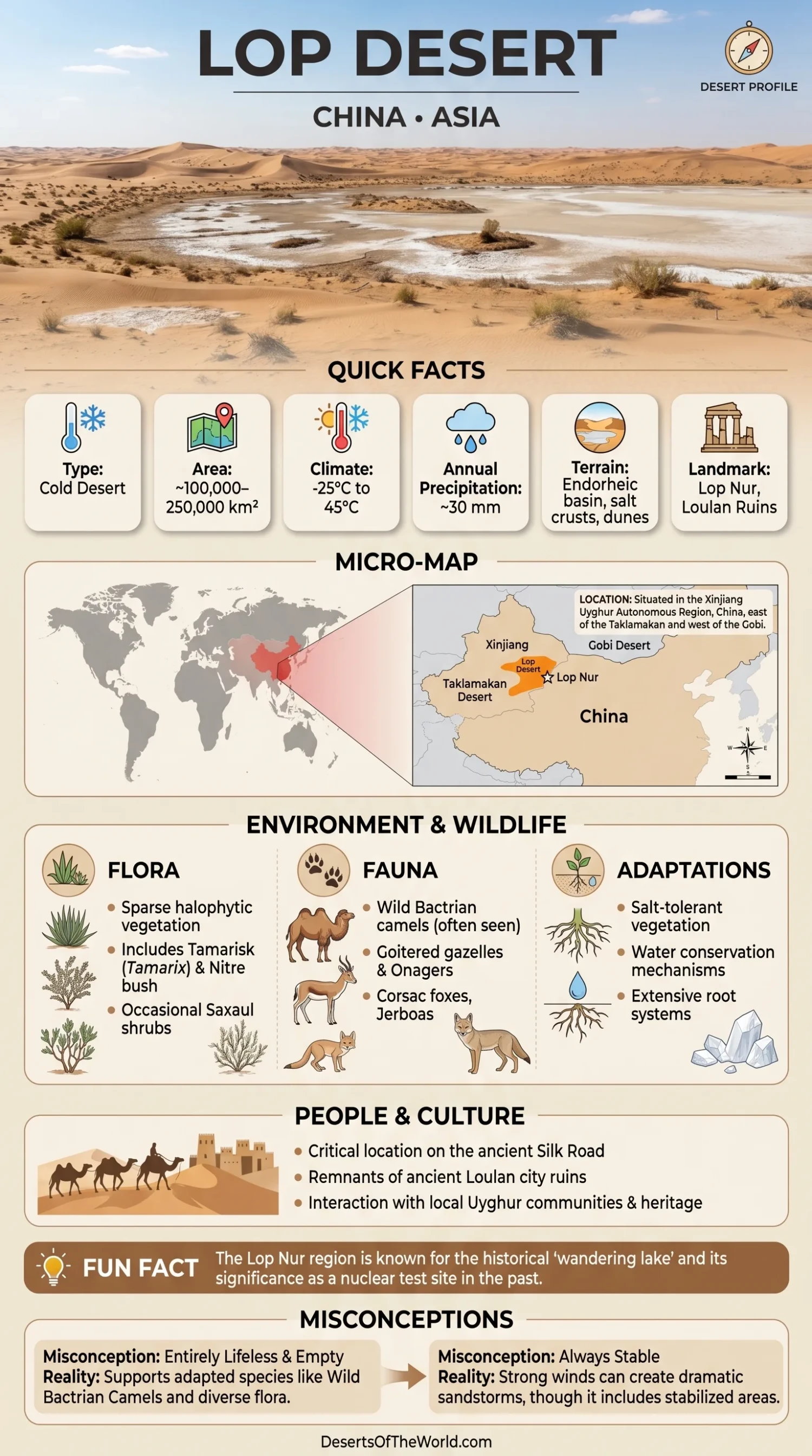
Location & Continent
Continent: Asia
Country: China
Region: Xinjiang Uyghur Autonomous Region, eastern Tarim Basin
Coordinates: ~40°10′N, 90°35′E
Lop Desert – Map & Satellite View
Physical Features
Area: About 50,000 km² under the commonly cited Lop Desert definition; boundaries vary depending on whether neighboring basin and desert terrain is included
Lop Nor Basin: More than 20,000 km² within the eastern Tarim Basin
Elevation: The Lop Nur depression lies at about 780 m above sea level
Surface: Salt crusts, clay flats, gravel desert, yardangs, former lake sediments, and localized sand deposits
Climate & Precipitation
Climate: Extremely arid continental desert climate
Temperature: Very hot summers and cold winters, with large annual and daily temperature ranges
Precipitation: Around 17 mm annually in Lop Nur according to Chinese Academy of Sciences climate research
Evaporation: Approximately 2,700 mm or more annually, far exceeding precipitation
Ecological Features
Biogeographic Realm: Palearctic
Environment: Temperate desert, saline playa, gravel desert, dry mountain valleys, and sparse desert shrubland
Protected Area: Xinjiang Lop Nur Wild Camel National Nature Reserve covers about 61,200 km² across parts of Bayingolin, Hami, and Turpan
Flora & Fauna
Flora: Tamarisk, Nitraria, saxaul, Calligonum, reeds in wetter drainage areas, salt-tolerant shrubs, and other sparse desert plants
Fauna: Wild Bactrian camel, goitered gazelle, Tibetan wild ass in adjoining uplands, argali, Tarim hare, reptiles, desert birds, and small mammals
Reserve Records: Xinjiang environmental authorities report 261 wild vertebrate species and 130 vascular plant species within the Lop Nur Wild Camel National Nature Reserve
Geology & Notable Features
Geology: A closed sedimentary depression at the eastern end of the Tarim Basin, containing thick lake deposits, evaporite minerals, salt crusts, clay surfaces, wind-eroded ridges, and brine deposits
Notable Features: Dried Lop Nur lake bed, yardang fields, salt-encrusted playa surfaces, Loulan archaeological site, Kuruktag Mountains, Kumtag Desert margin, and the Lop Nur Wild Camel National Nature Reserve
Lop Desert and Lop Nur
The Lop Desert, also called the Lop Depression, occupies the eastern part of China’s Tarim Basin in Xinjiang. It is closely associated with Lop Nur, the former terminal lake that once received water from the Tarim River system.
The desert is better known for its broad clay and salt surfaces than for large dune seas. Former lake beds, salt crusts, gravel plains, yardangs, and low-relief desert terrain dominate much of the region. The Lop Nur depression forms one of the lowest parts of the Tarim Basin at roughly 780 m above sea level.
The name Lop Desert is sometimes applied inconsistently to a much larger part of the eastern Tarim Basin. A figure of about 50,000 km² is commonly used for the Lop Desert itself, while geological studies place the Lop Nor basin at more than 20,000 km². Figures such as 100,000 or 250,000 km² generally combine wider surrounding desert terrain and should not be treated as equivalent measurements of the same feature.
Geography
The Lop Desert lies east of the central Taklamakan sand sea and south of the Kuruktag Mountains. The Kumtag Desert approaches from the southeast, while low mountains and dry valleys separate parts of the basin from adjoining desert regions.
The central Lop Nur landscape is remarkably flat in topographic terms. Many surfaces differ by only a few meters in elevation across broad distances. This low relief reflects the area’s former role as the terminal collecting basin for rivers draining the eastern Tarim system.
- Former Lake Floor: Fine clay and salt-rich sediment covers large sections of the dried Lop Nur basin.
- Salt Crusts: Evaporation concentrated dissolved minerals as lake and groundwater levels declined.
- Yardangs: Wind erosion has carved elongated ridges from consolidated lake and river sediments.
- Gravel Desert: Stony surfaces occur toward mountain fronts and on parts of the surrounding basin.
- Sand: Dunes and windblown sand occur locally but do not define the whole Lop landscape.
Lop Nur: From Terminal Lake to Dry Playa
Lop Nur was the terminal lake of the Tarim Basin drainage system. Water arriving from rivers originating in the mountains around the Tarim Basin collected in this low eastern depression because there was no outlet to the sea.
The lake changed in size, salinity, and position over long periods as river channels shifted and regional water supply varied. Sediment studies show that Lop Nur experienced repeated changes between fresher and highly saline conditions during the Holocene.
During the twentieth century, diversion and consumption of water upstream combined with the region’s naturally dry climate to reduce inflow sharply. Chinese Academy of Sciences reporting states that the remaining Lop Nur lake dried in 1972.
The former lake floor now contains salt-rich sediment, evaporite crusts, and subsurface brines. Some areas display concentric patterns left by the retreat and evaporation of water, visible clearly in satellite imagery.
Climate
Lop Nur lies in one of the driest parts of the Tarim Basin. Chinese Academy of Sciences research gives a mean annual precipitation of only about 17 mm for the Lop Nur area, compared with annual evaporation of approximately 2,728 mm.
Other studies of the basin report similarly low rainfall, in some cases below 20 mm annually. The surrounding mountain systems restrict the arrival of moist air, while the continental interior location produces strong seasonal temperature changes.
Summers are intensely hot and dry. Winters are cold, and temperatures can fall well below freezing. Strong winds redistribute dust and sand and also shape the yardang terrain on exposed former lake sediments.
Yardangs and Wind-Eroded Terrain
Yardangs are among the characteristic landforms of the Lop Nur region. They develop where persistent winds erode relatively soft sediment into long ridges separated by grooves or corridors.
Many Lop Nur yardangs formed in former lake or river sediments. Their orientation records dominant wind directions, while differences in sediment hardness control how quickly individual ridges erode.
The result is a landscape of parallel and branching ridges rather than conventional sand dunes. In satellite images, these wind-carved surfaces can extend across large sections of the basin.
Salt Crusts and Subsurface Brines
The dried Lop Nur basin contains extensive evaporite deposits created as mineral-rich lake and groundwater repeatedly concentrated through evaporation.
Scientific studies describe the Lop Nor basin as one of China’s major potash-bearing brine regions. Salt-rich depressions contain minerals formed through repeated dissolution, precipitation, recrystallization, and concentration of groundwater.
In the Luobei depression, salt strata can reach tens to more than 100 m in thickness. The modern surface includes broad salt crusts over low-lying parts of the basin.
Vegetation and Wildlife
The central salt playa supports little vegetation, but the wider Lop Nur region includes dry valleys, mountain foothills, desert shrubland, and areas where groundwater allows more plant growth.
Plants recorded within the Lop Nur Wild Camel National Nature Reserve include saxaul, tamarisk, Calligonum, Nitraria, and other species adapted to drought or saline soil.
The reserve was created primarily to protect the wild Bactrian camel, one of the rarest large desert mammals. Xinjiang environmental authorities describe the Lop Nur region as one of its principal remaining habitats. A 2017 reserve profile estimated about 600 wild camels within the protected area at that time.
The same reserve records goitered gazelle, argali, Tibetan wild ass in suitable sectors, Tarim hare, reptiles, birds, and other desert wildlife. These animals are concentrated in habitats where terrain, vegetation, springs, or groundwater provide usable conditions rather than on the barren salt playa itself.
Lop Nur Wild Camel National Nature Reserve
The Xinjiang Lop Nur Wild Camel National Nature Reserve covers approximately 61,200 km². It spans portions of Bayingolin Mongol Autonomous Prefecture, Hami, and Turpan and includes northern Lop Nur, parts of the Kuruktag region, the Aqike Valley, and desert terrain toward the Altun Mountains and Kumtag.
The protected area includes core, buffer, and experimental zones. Its purpose centers on wild Bactrian camel habitat and the wider desert ecosystem supporting the species.
Monitoring programs have used satellite collars, camera traps, field surveys, automatic ecological stations, and patrol systems to follow camel movements and document other wildlife.
Loulan and the Silk Roads
The ancient city of Loulan developed near the former Lop Nur lake and river network. Water supported irrigated agriculture and settlement in terrain that is now extremely dry.
Archaeological studies have identified abandoned farmland, canals, wooden documents, textiles, pottery, and settlement remains around the Loulan region. Research published through the Chinese Academy of Sciences has documented thousands of hectares of former agricultural land west of Lop Nur.
Loulan occupied a strategic position where routes passing west from the Hexi Corridor entered the Tarim Basin. UNESCO’s documentation for the Chinese section of the Silk Roads lists the Ancient City of Loulan among sites proposed for the wider Chinese Silk Roads heritage network.
The broader UNESCO-listed Chang’an–Tianshan Corridor describes Silk Road routes continuing westward from the Loulan and Hami area toward the northern and southern sides of the Tian Shan.
Lop Nur Nuclear Test Area
The name Lop Nur is also associated with China’s former nuclear weapons testing program. The test area was located in the Kuruktag and Kyzyltag mountains near the desert basin rather than on the central dried lake floor alone.
U.S. Geological Survey work on the site records underground nuclear testing between 1969 and 1992. Tests used both vertical shafts and horizontal tunnels depending on terrain and bedrock conditions.
This historical test area is distinct from the Lop Nur Wild Camel National Nature Reserve and from the Loulan archaeological site, although all lie within the wider eastern Tarim Basin region.
Tarim River Water Management
Water management in the Tarim Basin has changed conditions in some areas upstream of Lop Nur. Ecological water releases began in the lower Tarim River in 2000 to raise groundwater levels and restore riparian vegetation along sections of the river corridor.
Chinese Academy of Sciences satellite and groundwater studies reported that declining groundwater around the wider Lop Nur region slowed after 2010 and showed partial recovery in later observations. This does not mean that the former Lop Nur lake has returned. The central historical lake basin remains predominantly dry.
The distinction is important: recovering groundwater or temporary surface water in parts of the Tarim system is different from restoration of the former terminal lake.
Access and Protected Areas
The Lop Nur region is remote and includes protected habitat, archaeological areas, active mineral operations, and historically controlled zones. It should not be treated as an unrestricted trekking destination.
The Wild Camel National Nature Reserve is managed as a protected area, and access conditions depend on location and activity. Archaeological sites such as Loulan also fall under cultural heritage management. Anyone planning fieldwork or authorized travel in the wider Lop Nur region should verify current access rules with the relevant Chinese and Xinjiang authorities before entering remote desert areas.
Extreme heat, winter cold, lack of surface water, long distances between settlements, salt flats, and difficult navigation add practical hazards even outside restricted areas.
Lop Desert and Lop Nur Measurements
| Feature | Measurement or Status |
|---|---|
| Lop Desert | About 50,000 km² under a commonly cited geographic definition |
| Lop Nor Basin | More than 20,000 km² |
| Lop Nur Elevation | About 780 m above sea level |
| Annual Precipitation | About 17 mm in Chinese Academy of Sciences climate research |
| Annual Evaporation | Approximately 2,728 mm in the same regional climate study |
| Modern Lake Drying | 1972 |
| Wild Camel Reserve | Approximately 61,200 km² |
Conclusion
The Lop Desert occupies the eastern Tarim Basin around the dried Lop Nur depression. Its defining surfaces are former lake beds, salt crusts, yardangs, clay flats, and gravel terrain rather than a continuous field of high dunes.
Lop Nur once collected water from the Tarim drainage system but dried in 1972 after decades of declining inflow. The same basin preserves traces of earlier lake phases, Loulan’s irrigated settlement landscape, extensive evaporite deposits, and some of the remaining habitat of the wild Bactrian camel. These features make the area’s hydrological history central to understanding both its present desert surface and the archaeological record around the former lake.
References
Scientific and Government Sources
- Chinese Academy of Sciences – Vegetation and Climate of the Lop Nur Area
- Chinese Academy of Sciences – Lop Nur Vegetation and Environmental History
- Chinese Academy of Sciences – Water and Groundwater Change in the Lop Nur Region
- Chinese Academy of Sciences – Ecological Water Conveyance in the Lower Tarim River
- Xinjiang Department of Ecology and Environment – Lop Nur Wild Camel National Nature Reserve
- Xinjiang Forestry and Grassland Administration – Lop Nur Wild Camel Reserve Management Center
- U.S. Geological Survey – Geology of the Lop Nor Nuclear Test Site
Archaeology and Silk Roads
- UNESCO World Heritage Centre – Chinese Section of the Silk Roads, including Ancient City of Loulan
- UNESCO World Heritage Centre – Silk Roads: Routes Network of Chang’an–Tianshan Corridor
- Chinese Academy of Sciences – Ancient Loulan Agriculture and Environmental History