
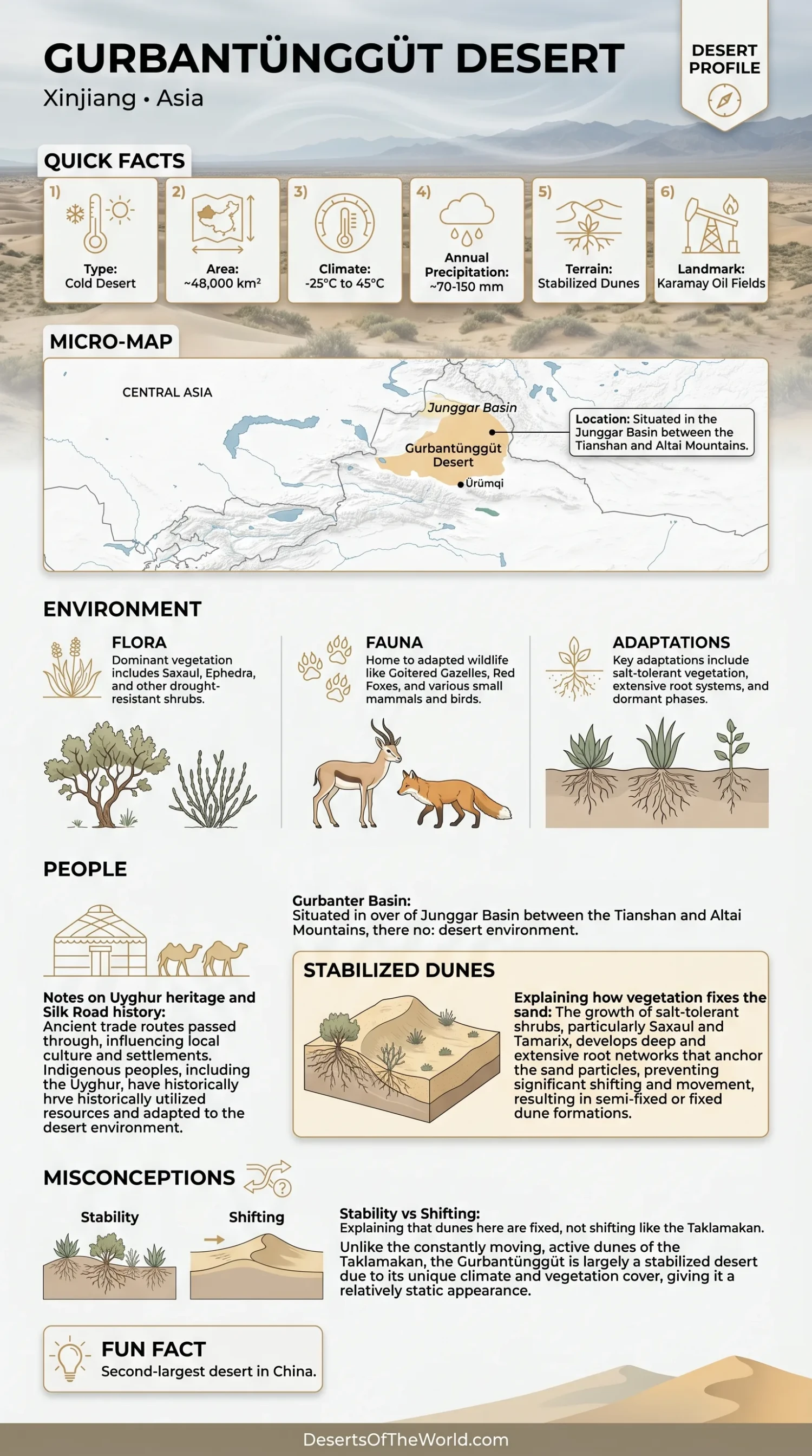
The Gurbantünggüt Desert occupies the dry interior of the Junggar Basin in northern Xinjiang, northwestern China. Covering about 48,800 km², it is generally ranked as China’s second-largest desert after the Taklamakan. Yet size is not what makes this desert unusual. Much of its sand surface is fixed or semi-fixed by vegetation and biological soil crusts, giving Gurbantünggüt a very different character from highly mobile sand seas.
Its position between major Central Asian mountain systems creates a cold temperate desert climate. Winter snow, spring meltwater, short-lived plants, drought-resistant shrubs and crust-forming organisms interact with the dunes in ways rarely associated with the popular image of a desert. In spring, parts of the sandy landscape can support a brief layer of herbaceous growth before summer dryness returns.
Location in the Junggar Basin
The Gurbantünggüt Desert lies within the Junggar Basin, one of the large enclosed basins of Central Asia. The Tian Shan rise to the south, while the Altai region lies farther north. These mountain systems help isolate the basin from direct maritime moisture and strongly influence regional air circulation, precipitation and sediment movement.
The desert occupies much of the basin’s central lowland. Published descriptions commonly place large parts of the sandy interior at roughly 300–600 meters above sea level, although elevation changes toward basin margins and adjacent uplands.
This geographic setting also explains why the Gurbantünggüt differs from the Taklamakan Desert south of the Tian Shan. The two deserts are in separate basins and experience different combinations of wind, winter moisture, vegetation cover and dune mobility.
Why So Much of the Desert Is Fixed or Semi-Fixed
A fixed desert does not mean that every grain of sand is immobile. It means that vegetation, roots, surface crusts and local moisture have reduced wind-driven sand movement enough for many dunes to maintain relatively stable forms.
Research commonly describes about 90–95% or more of the Gurbantünggüt sandy area as fixed or semi-fixed. Exact percentages vary among surveys and definitions, so the number should be treated as a broad landscape estimate rather than a permanent measurement.
Three processes work together:
- Shrubs anchor dune surfaces. Their roots bind subsurface sand while stems reduce wind velocity close to the ground.
- Ephemeral plants cover open spaces for part of the year. They germinate when temperature and soil moisture briefly become favorable.
- Biological soil crusts bind the uppermost sand. Cyanobacteria, algae, lichens and mosses can form living surface layers between vascular plants.
The result is a landscape where sand dunes remain clearly visible but are often partly vegetated. Bare, semi-fixed and more stable patches can occur within the same dune system.
Dune Forms and Sand-Ridge Structure
Longitudinal dunes are among the best-known landforms of the Gurbantünggüt Desert. Field studies have described many ridges running broadly north–south, with individual dunes commonly reaching around 10–50 meters in height. Some ridges extend for many kilometers.
The desert is not made of one repeated dune shape. Researchers have recorded dendritic, honeycomb, longitudinal and compound dune patterns. Intersections between ridges can create branching or cellular forms when winds from different directions redistribute sand over long periods.
| Dune Feature | What It Looks Like | What Controls It |
|---|---|---|
| Longitudinal ridges | Long, narrow sand ridges extending across the desert surface | Persistent wind patterns, vegetation and sediment supply |
| Dendritic dunes | Branching ridge networks resembling connected limbs | Changing wind directions and interaction between older dune ridges |
| Honeycomb forms | Intersecting ridges enclosing small sandy cells | Multidirectional winds and dune-ridge intersections |
| Coppice dunes | Sand accumulations formed around shrubs | Plant stems trap wind-blown sediment around vegetation |
| Interdune areas | Lower ground between dune ridges | Topography, soil texture, runoff and moisture redistribution |
What Recent Sediment Measurements Show
A large sediment dataset published in late 2025 provides unusually detailed physical information about the desert’s dunes. Researchers sampled 67 sampling zones and 424 sites, producing 1,859 sediment samples from different dune types, slope positions and sediment profiles.
The project classified samples across nine dune-type groups and measured particle-size distributions with laser diffraction. The laboratory instrument covered particles from 0.02 to 2,000 micrometers. These measurements allow researchers to compare sorting, mean grain size, skewness and particle fractions across different parts of the dune field.
Why does grain size matter? Wind cannot move every particle equally. Fine grains can travel much farther than coarse sand, while vegetation changes near-surface airflow and traps particular sediment fractions. Variations in sand texture therefore contain information about wind energy, sediment sources and dune development.
Climate, Rainfall and Temperature
The Gurbantünggüt is a temperate continental desert with cold winters, hot summers and a large seasonal temperature range. Long-term research commonly places mean annual temperature near 5–7°C across study areas, though conditions vary with latitude, elevation and position within the Junggar Basin.
Annual precipitation is often reported in the range of 70–150 mm. That is still desert-level moisture, but its timing changes the ecology. Part of the precipitation arrives during the colder part of the year and can remain temporarily stored as snow.
Summer conditions are much warmer. Research from the broader Junggar desert landscape reports average July temperatures above 27°C at some study locations, while winter temperatures fall far below freezing. The desert therefore combines two stresses that are rarely shown in photographs together: summer water shortage and winter cold.
Winter Snow as a Seasonal Water Store
Snow is one of the defining ecological features of the Gurbantünggüt Desert. A winter snow layer can remain on parts of the desert for several months, insulating the soil and storing water until temperatures rise.
When snow melts, water enters the upper soil during a period when evaporation remains lower than it will be in summer. This creates a temporary moisture window. Seeds respond quickly. So do mosses, lichens and other members of the biological soil crust.
Experiments in the desert have shown that changing snow depth can alter soil water, nutrient conditions, microbial biomass and biological-crust activity. More snow does not produce identical effects everywhere, because dune position, crust type, soil texture and melt timing change how much water remains available.
Spring Ephemeral Plant Communities
One of the desert’s most distinctive biological features is its population of ephemeral plants. These species complete much of their visible life cycle during a narrow period when moisture and temperature align.
Some germinate in autumn, survive winter in an early developmental stage and resume growth in spring. Others germinate after winter. They grow rapidly, flower, produce seed and then decline as the surface becomes hotter and drier.
Erodium oxyrrhynchum is one species used frequently in ecological research in the Gurbantünggüt. Its behavior helps scientists study how germination season, soil moisture and biological crust development influence plant growth.
What 2026 Research Adds
A January 2026 field study examined Erodium oxyrrhynchum growing across different stages of biological soil-crust development: bare sand, algal crust, lichen crust and moss crust.
The researchers found that autumn-germinated plants generally produced more aboveground biomass than spring-germinated plants. They also found a gradual decrease in aboveground biomass along the sequence from bare sand → algal crust → lichen crust → moss crust.
That result reveals an interesting ecological balance. Mature crusts can enrich or modify surface soil, yet they also change how water moves and how plants gain access to it. In the experiment, soil moisture and nutrient availability were the main controls on plant biomass, with microbial communities and plant traits adding further effects.
Biocrusts therefore should not be described simply as either “good” or “bad” for vascular plants. Their effect depends on the plant, season, water supply and stage of crust development.
Biological Soil Crusts Between the Dunes
Look closely at stable desert ground and the surface is not always loose sand. Dark, greenish, gray or textured patches can be biological soil crusts, often shortened to biocrusts.
These communities can contain:
- cyanobacteria and algae,
- lichens,
- mosses,
- fungi and other microorganisms associated with the crust layer.
As these organisms grow, filaments and biological material connect mineral grains near the surface. This can improve resistance to wind erosion and alter water infiltration, evaporation, carbon cycling and nutrient distribution.
The Gurbantünggüt has become an especially useful natural laboratory for biocrust research because large areas contain both sandy dunes and established crust communities. Researchers can compare bare sand with several stages of crust development across similar climatic conditions.
Why Crust Cover Changes Across a Single Dune
A dune crest and an interdune hollow may sit only a short distance apart, yet their surfaces experience different wind exposure, sand burial, solar heating and moisture retention. Biocrusts respond to those small-scale differences.
More exposed crest areas generally experience stronger wind and more frequent sand movement. Lower or sheltered positions can hold moisture longer and allow more stable crust development. Grain size matters too. Studies of the desert have linked precipitation and soil particle size with the spatial distribution of biological crusts.
This small-scale patchwork is one reason a single vegetation percentage cannot describe the whole desert accurately.
Haloxylon Shrublands and Long-Lived Vegetation
Permanent woody vegetation gives much of the Gurbantünggüt its semi-fixed character. Species of Haloxylon, often called saxaul in Central Asian desert literature, are among the characteristic shrubs.
Haloxylon ammodendron tolerates drought, sandy soils and saline conditions. Its branches reduce wind speed near the ground while its root system extracts water from below the rapidly drying surface layer. Sand can accumulate around established shrubs, creating small vegetated mounds and coppice-like dune forms.
The space below and around a shrub can also differ chemically and physically from open sand. Wind-blown organic material accumulates, shade lowers surface heating for part of the day, and roots change local soil structure. Desert vegetation therefore creates a mosaic of plant-centered microhabitats.
How Tamarix Uses Water Below Coppice Dunes
A 2026 study on Tamarix ramosissima at the southwestern edge of the Gurbantünggüt measured water use with stable isotopes and plant physiological data. The work compared shrubs growing on coppice dunes at different developmental stages.
During dry periods, plants shifted toward deeper soil water. Researchers examined layers down to 5 meters. Shrubs on declining-stage coppice dunes showed especially strong dependence on water stored between 1.8 and 5 meters during drought; one measured condition produced an estimated deep-water contribution of 86.5%.
Small rainfall events produced a different response. After a 7 mm precipitation pulse, shrubs increased their use of water from the upper 0–60 cm of soil. A smaller 4.2 mm event caused only a short-lived increase in shallow-water use.
This shows how desert shrubs switch between water sources rather than relying on one fixed depth throughout the year. A few millimeters of rain can matter, but only briefly.
How Water Moves Through Sandy Soil
Desert sand can absorb water quickly, but that does not mean the water remains near the surface. Strong evaporation removes shallow moisture, while gravity carries part of the water downward.
Within the Gurbantünggüt, soil moisture varies with:
- dune position — crest, slope and interdune ground receive and retain water differently;
- vegetation cover — roots extract moisture while plant canopies modify evaporation and wind;
- snow accumulation — sheltered places can collect more snow;
- grain size — finer and coarser sediments differ in water retention and infiltration;
- rainfall size — a brief light shower may wet only shallow layers, while a larger event can recharge deeper soil.
The combination produces sharp moisture differences over surprisingly short distances. For desert plants, centimeters of topographic relief and centimeters of soil depth can both matter.
Wildlife in the Sandy Desert Ecosystem
The dunes support more than plant communities. Research within the Gurbantünggüt and wider Junggar desert landscape records desert rodents, reptiles and larger mammals adapted to open sandy and shrub-covered habitats.
The Siberian jerboa has been studied in the desert using infrared cameras to understand daily activity patterns. The great gerbil (Rhombomys opimus) is another well-documented rodent associated with the region’s desert and semi-desert habitat.
Small mammals influence the vegetation as well as use it. Burrowing changes soil structure, exposes buried material and creates small patches where water, seeds and nutrients behave differently. Research on short-lived plants in the Gurbantünggüt has therefore examined plant responses to rodent disturbance as part of normal desert ecosystem dynamics.
Across the wider Junggar Basin, shrub desert also provides habitat for animals such as goitered gazelles and several specialized Central Asian reptiles. Their distribution is not uniform across every part of the Gurbantünggüt, so basin-wide species lists should not be treated as records for every dune field.
Geology and the Origin of the Desert Sand
The Gurbantünggüt sits within a sediment-filled basin surrounded by mountain systems that have supplied mineral material over geological time. Rivers, older lake deposits, weathering and wind have all contributed sediment that could later be reworked into dunes.
The present sand field is therefore not simply a pile of material blown in from one direction. Mineralogical and grain-size differences show that sediment sources and transport pathways vary across the desert.
Recent work on dune sediments has emphasized spatial contrasts between different areas and dune forms. Northern, western, southern and interior sites do not necessarily contain identical sediment populations. Once sand reaches the basin interior, repeated wind transport sorts grains further and reshapes them into new dune forms.
Wind and Aeolian Processes
Aeolian simply means produced or transported by wind. In Gurbantünggüt, wind lifts fine particles, pushes sand grains along the surface and slowly modifies dune slopes.
Vegetation changes that process. A shrub interrupts airflow and creates zones of lower wind speed immediately around it. Sand settles there. Biological crusts further reduce the amount of loose sediment available for transport.
This is why dune stability is best understood as a balance between wind energy, available sand, vegetation, biocrust cover and seasonal moisture. Change any one of those and the surface can respond.
A Desert Defined by Strong Seasonal Change
| Season | Typical Surface Conditions | Ecological Response |
|---|---|---|
| Winter | Cold conditions, frozen ground in places and recurring snow cover | Snow stores water and insulates parts of the soil surface |
| Early Spring | Snowmelt raises shallow soil moisture | Ephemeral plants germinate or resume growth; biocrust activity rises |
| Late Spring | Temperatures rise and surface water declines | Many short-lived plants flower and produce seed |
| Summer | Hot, dry surface conditions and strong evaporation | Long-lived shrubs depend more heavily on deeper soil water |
| Autumn | Cooling temperatures and occasional precipitation | Some ephemeral species may germinate before winter |
This seasonal rhythm explains the apparent contradiction of a sandy desert that can have snow in winter, flowers in spring and drought-resistant shrubland through summer. Each phase uses a different part of the same limited water supply.
Gurbantünggüt and Taklamakan Compared
The Gurbantünggüt and Taklamakan are both major deserts of Xinjiang, but treating them as interchangeable hides basic physical differences.
| Feature | Gurbantünggüt Desert | Taklamakan Desert |
|---|---|---|
| Basin | Junggar Basin | Tarim Basin |
| Relative Size | About 48,800 km² | Far larger |
| Sand Stability | Extensive fixed and semi-fixed dunes | Much larger areas of active dune fields |
| Winter Character | Cold desert with ecologically relevant seasonal snow | Cold winters occur, but the hydrological and vegetation pattern differs |
| Vegetation | Relatively broad shrub, ephemeral-plant and biocrust cover in many areas | Sparser across much of the interior dune field |
| Characteristic Landscape | Vegetated longitudinal and compound dune systems | Very large mobile sand seas and high dune systems |
Both deserts belong to the wider arid landscape of Central Asia, yet the Tian Shan separates their basins and contributes to different climatic and ecological patterns.
Why Scientists Study the Gurbantünggüt Desert
The Gurbantünggüt brings several desert processes together within one landscape: dune stabilization, seasonal snow, ephemeral vegetation, shrub water use and biological soil crust development. That combination allows researchers to study interactions that are harder to isolate in deserts dominated almost entirely by bare mobile sand.
Recent studies also benefit from stronger datasets. The 2025 dune-sediment project created measurements from hundreds of sites, while 2026 plant studies have added field evidence on biocrust–plant relationships and deep-versus-shallow water use.
These studies show why long-term observations matter. A desert’s surface may look static from a distance, yet water pathways, plant activity, microbial processes and sediment movement change from season to season.