A desert is not simply a place full of sand. In earth science, a desert is a land area with very low precipitation and a lasting moisture deficit. That means the land usually loses more water through evaporation and plant transpiration than it gains from rain or snow. This is why a rocky plateau, a salt flat, or even an icy polar plain can still be a true desert landscape.
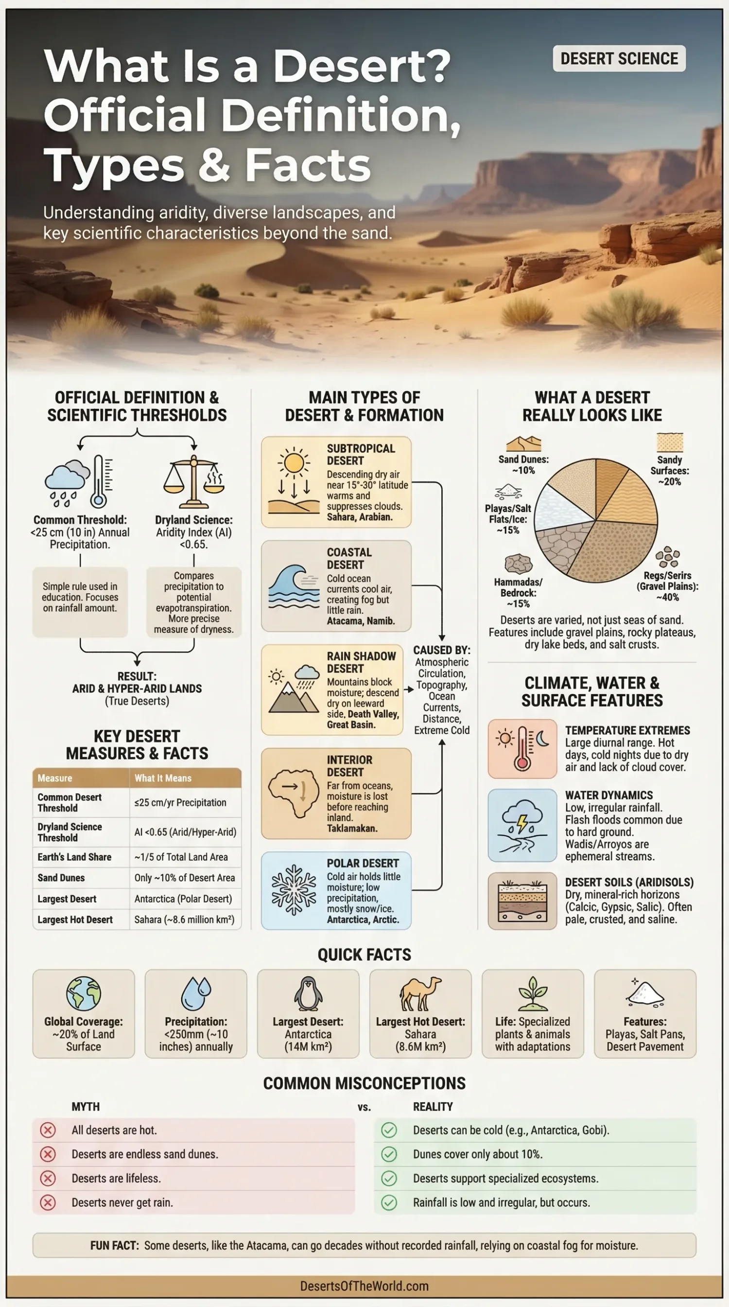
The usual working definition is simple: a desert gets no more than about 25 centimeters (10 inches) of precipitation in a year. That rule is widely used in education and field geography because it is easy to understand. In dryland science, researchers also use a more technical measure called the Aridity Index, which compares annual precipitation with potential evapotranspiration. That second method gives a sharper picture of how dry a place really is.
| Measure | What It Means |
|---|---|
| Common Desert Threshold | 25 cm (10 in) or less of yearly precipitation |
| Dryland Science Threshold | Aridity Index below 0.65 marks drylands; the driest desert zones fall in the hyper-arid and arid bands |
| Share Of Earth’s Land | Deserts cover about one-fifth of Earth’s land area |
| Sand Dunes | Dunes make up only about 10% of the world’s deserts |
| Largest Desert On Earth | Antarctica, a cold polar desert |
| Largest Hot Desert | Sahara, about 8.6 million km² |
Official Definition And Scientific Thresholds
There is no single worldwide legal sentence that all institutions use word for word. Still, the scientific meaning is stable. A desert is land with very little precipitation, sparse plant cover, and limited water available for life. In many textbooks, park systems, and geography references, the line sits at 25 centimeters of precipitation per year.
Dryland science adds a more exact tool: the Aridity Index, written as precipitation / potential evapotranspiration. In plain language, it asks a simple question: how much water falls from the sky, and how much water could the climate pull back out? When that ratio is very low, the land behaves like a desert even if the yearly rainfall number alone looks borderline.
The usual dryland classes are these:
- Hyper-Arid: AI below 0.05
- Arid: AI from 0.05 to 0.20
- Semi-Arid: AI from 0.20 to 0.50
- Dry Sub-Humid: AI from 0.50 to 0.65
This point matters because not every dryland is a desert. Semi-arid steppe and dry grassland may feel harsh and water-limited, yet they are not always true desert. Thats where many short definitions go a bit off track.
Main Types Of Desert
Deserts are often grouped by how their dryness forms, not only by how hot they are. This approach explains why the Sahara, the Atacama, the Gobi, and Antarctica all fit under the same broad idea while looking nothing alike.
Subtropical Desert
A subtropical desert forms under descending dry air near roughly 15° to 30° latitude north and south. This is the classic hot desert belt. The Sahara, Arabian Desert, and many Australian deserts belong here. Air sinks, warms, and blocks cloud growth, so rainfall stays low.
Coastal Desert
A coastal desert sits next to a cold ocean current. The air may hold fog, yet rain stays rare. The Atacama Desert is the textbook case. In parts of it, rainfall has never been recorded, while fog from the Pacific side still brings small amounts of moisture to plants, soils, and people using fog nets.
Rain Shadow Desert
A rain shadow desert forms on the dry side of a mountain barrier. Moist air drops rain on the windward side, then descends drier on the leeward side. Death Valley is a strong example. Several mountain ranges strip moisture from incoming air before it ever reaches the basin.
Interior Desert
An interior desert lies far from oceans. By the time air masses move deep into a continent, much of their moisture is gone. The Gobi fits this pattern. It is dry not because it sits in tropical heat, but because distance and topography leave little water in the air.
Polar Desert
A polar desert is cold all year or nearly so, yet still very dry. Antarctica is the largest desert on Earth. Snowfall over much of the continent is low in water equivalent, and most water is locked in ice, not available for roots, streams, or easy biological use.
Why Deserts Form
Several physical systems create desert climates. They often overlap. A place may be dry because of sinking subtropical air, cold offshore currents, mountain rain shadows, continental distance, or persistent polar cold.
Descending Air In The Subtropics
Near the subtropics, global circulation pushes air downward. As it sinks, it warms and dries. Cloud formation becomes harder. Less cloud means less rain. That simple chain helps shape many of the world’s best-known hot deserts.
Cold Ocean Currents
Cold currents cool the lower atmosphere above the sea. Fog can form, but vertical cloud growth stays weak. So the coast may feel damp while the annual rainfall total remains tiny. This is why the Atacama can be both foggy and very dry at the same time.
Mountain Barriers
Mountains act like climate walls. Air rises, cools, and drops moisture on one side. The air that descends beyond the crest is drier and warmer. Over time, that creates a rain shadow with limited runoff, sparse vegetation, and big day-night temperature swings.
Distance From Moisture Sources
Some deserts owe their dryness to sheer distance. The farther an air mass travels inland, the less moisture it may still carry. Interior Asia shows this well. A desert does not need tropical latitude to become dry. It needs a weak water supply.
Extreme Cold
Cold air holds less moisture than warm air. In polar settings, very low temperatures limit how much water vapor the atmosphere can carry. The result is a land of ice and snow that still qualifies as a desert because precipitation remains low.
What A Desert Really Looks Like
The common mental picture is a sea of dunes. Useful image, but only partly true. Sand dunes cover only about 10% of the world’s deserts, while all sandy surfaces together account for roughly 20%. Much of the rest is gravel plain, exposed bedrock, hardpan, salt crust, volcanic surface, or ice.
Many desert floors are made of regs and serirs, which are gravelly plains left behind after wind removes fine particles. Others are hammadas, rocky plateaus with very thin soil. Basin interiors often contain playas, flat dry lake beds where water appears briefly and vanishes again. Along mountain fronts, alluvial fans spread out like open stone hand-fans built by flash floods.
This is why a desert biome can look hard, cracked, smooth, pebbled, salty, or icy. Not just sandy. That old image still lingers, even though it misses most desert surfaces.
Climate, Water, And Temperature Patterns
Deserts are dry, but not all dry places behave the same way. Some get tiny drizzles spread through the year. Others receive almost nothing for years, then suddenly get a short, intense storm. A desert may have low yearly rainfall yet still face flash flooding because hard ground and sparse vegetation do not absorb water fast enough.
The atmosphere above a desert usually allows strong solar heating by day and rapid heat loss at night. That creates large diurnal ranges, meaning the difference between daytime and nighttime temperature can be wide. Dry air does not hold heat well after sunset. So a place that feels blistering in the afternoon can turn surprisingly cold before dawn.
Water in deserts often moves in short pulses. Streams may remain dry for long periods, then run fast after a storm. Such channels are called wadis, arroyos, or ephemeral streams, depending on region and context. In basin deserts, runoff may end in a closed depression rather than reaching the sea. That leads to salt build-up and the growth of playas and salt pans.
Desert Soils And Surface Features
Many desert soils belong to the Aridisol order. These soils are dry for long periods and often store minerals in distinct horizons rather than washing them down and away. That is one reason desert ground can become pale, crusted, or chemically layered.
Common soil and ground features include:
- Calcic Horizons: layers rich in calcium carbonate
- Gypsic Horizons: layers with gypsum accumulation
- Salic Horizons: salt-rich layers, common in playas and closed basins
- Desert Pavement: tightly packed pebbles left after fine sediment is removed
- Alluvial Fans: fan-shaped sediment bodies at mountain fronts
- Playas: dry lake beds in closed basins
These features are not random decoration. They record evaporation, sediment transport, basin drainage, and long periods of limited biological mixing. A desert surface is often a climate archive written in gravel, crust, and mineral bands.
Life In A Desert Is Not Sparse By Accident
Desert ecosystems support plants and animals shaped by water stress, heat load, cold nights, salt, and irregular food supply. The low biomass is real, yet the biological strategies are often very refined. A desert is not empty; it is selective.
Plants reduce water loss in different ways. Some open leaf pores at night rather than day. Some store water in stems or leaves. Others wait as seeds for the right short wet period, then grow, flower, and set seed quickly. In many deserts, roots spread wide rather than deep so the plant can capture a brief shower before the water disappears.
Animals solve the same problem differently. They may stay in burrows through the hottest hours, feed at night, draw water from food, or release very concentrated waste. Small changes matter a lot in a water-limited biome.
Examples That Show How Broad The Desert Idea Really Is
Antarctica
Antarctica is the world’s largest desert. Much of the continent receives very low annual precipitation, with snowfall equivalent to about 150 mm of rain. Its ice sheet covers nearly 14 million km². This is the clearest proof that a desert does not need heat or dunes to be real.
Sahara
The Sahara is the world’s largest hot desert, stretching about 4,800 km from west to east and covering about 8.6 million km². Even here, the classic sand-sea image tells only part of the story. The Sahara also includes gravel plains, rocky plateaus, mountain massifs, seasonal basins, wadis, oases, and salt depressions.
Atacama
The Atacama Desert on the Pacific side of South America is one of the driest places on Earth. In some parts, rainfall has never been recorded. Moisture often comes not from rain but from camanchaca, a dense fog tied to cold ocean conditions. That small detail changes how life survives there.
Death Valley
Death Valley shows what a rain shadow basin can do. Average rainfall is less than 5 cm a year. Summer temperatures often pass 49°C in the shade, and the basin floor drops to 86 m below sea level. Heat, topography, and dryness all stack on top of one another there.
Desert, Dryland, And Desertification Are Not The Same Thing
These terms are often mixed together, and that causes a lot of confusion.
- Desert: a very dry land area with low precipitation and limited available moisture
- Dryland: the wider group that includes arid, semi-arid, and dry sub-humid regions
- Desertification: land degradation in drylands caused by a mix of climatic variation and human activity
Desertification does not simply mean dunes marching across fertile land. In formal dryland work, it means the decline of land health in already dry regions. Soil structure can weaken, salts can build up, plant cover can thin, and water balance can shift. A place can suffer desertification without turning into a sand sea.
Facts That Correct Common Desert Myths
- Not All Deserts Are Hot. Antarctica is a desert.
- Not All Deserts Are Sandy. Dunes cover only a small part of global desert area.
- Low Rainfall Is Only Part Of The Story. Moisture loss also matters.
- Deserts Support Life. Their biodiversity is specialized, not absent.
- Flash Floods Still Happen. Dry ground can shed water very fast.
- Desert Soils Hold Clues. Salts, gypsum, and carbonates often build up near the surface.
- Drylands Are Broader Than Deserts. Semi-arid lands are dry, but not always desert.
Short Questions People Often Ask
Is Every Place With Little Rain A Desert?
No. Low rainfall is a major part of the definition, but scientists also look at water balance, vegetation, and aridity. Some low-rain landscapes fall into semi-arid or dry sub-humid classes instead.
Why Is Antarctica A Desert If It Is Covered In Ice?
Because desert status depends on very low precipitation, not on surface color or temperature. Most water there is frozen and not freely available to ecosystems.
Do Deserts Always Have Big Temperature Swings?
Many do, especially hot deserts with clear skies and very dry air. But not all desert regions behave the same way. Coastal fog deserts and polar deserts follow different temperature patterns.
Why Are There Salt Flats In Many Deserts?
Because many basin deserts are internally drained. Water flows in, evaporates, and leaves salts behind. Over time the surface becomes crusted, flat, and bright.
Sources
- National Geographic Education – Desert (definition, global extent, desert types, dune share, drylands context)
- U.S. Geological Survey – Deserts (annual precipitation threshold and biodiversity context)
- IPCC – Figure 3.1 On Drylands And Aridity Index (AI thresholds for humid, dry sub-humid, semi-arid, arid, and hyper-arid zones)
- UNCCD – Desertification (formal meaning of desertification and dryland categories)
- British Antarctic Survey – Antarctic Factsheet And Geographical Statistics (Antarctica as a desert, precipitation equivalent, ice sheet scale)
- NASA – Frequently Asked Questions About Antarctica (why Antarctica counts as a desert)
- USDA NRCS – Aridisols (desert soils, aridic moisture regime, calcic, gypsic, and salic horizons)
- U.S. Geological Survey – Desert Features (sand share, gravel plains, bedrock, playas, and alluvial fans)
- U.S. Geological Survey – Playas (how playas form in closed basins)
- U.S. National Park Service – Death Valley Weather And Climate (rain shadow effect, rainfall, heat, basin depth)
- European Space Agency – The Atacama Desert, Chile (areas with no recorded rainfall and camanchaca fog)
- Britannica – Sahara (area, dimensions, and major landforms of the Sahara)