Desert wadis are the dry river valleys that give many arid landscapes their hidden drainage system. For most of the year, a wadi may look like a gravel corridor, a sandy channel, or a quiet valley between cliffs. After rain, it can change fast. Water gathers from slopes, gullies, plateaus, and mountain fronts, then runs through the channel as a short-lived desert river. That contrast—dry bed, sudden flow—is what makes wadis one of the most useful landforms for understanding how deserts move water.
| Feature | Meaning in Desert Geography |
|---|---|
| Common Form | A dry valley, ravine, or riverbed that carries water mainly after rainfall. |
| Hydrology Type | Usually ephemeral or intermittent, meaning flow is short-lived and tied to rain or seasonal runoff. |
| Typical Regions | North Africa, the Sahara margins, the Arabian Peninsula, the Levant, and other drylands with similar landforms. |
| Related Terms | Arroyo, dry wash, desert wash, gully, ravine, ephemeral stream, alluvial channel. |
| Main Desert Role | Moves water and sediment, supports narrow bands of vegetation, recharges some groundwater, and shapes valleys, fans, and plains. |
What Desert Wadis Are
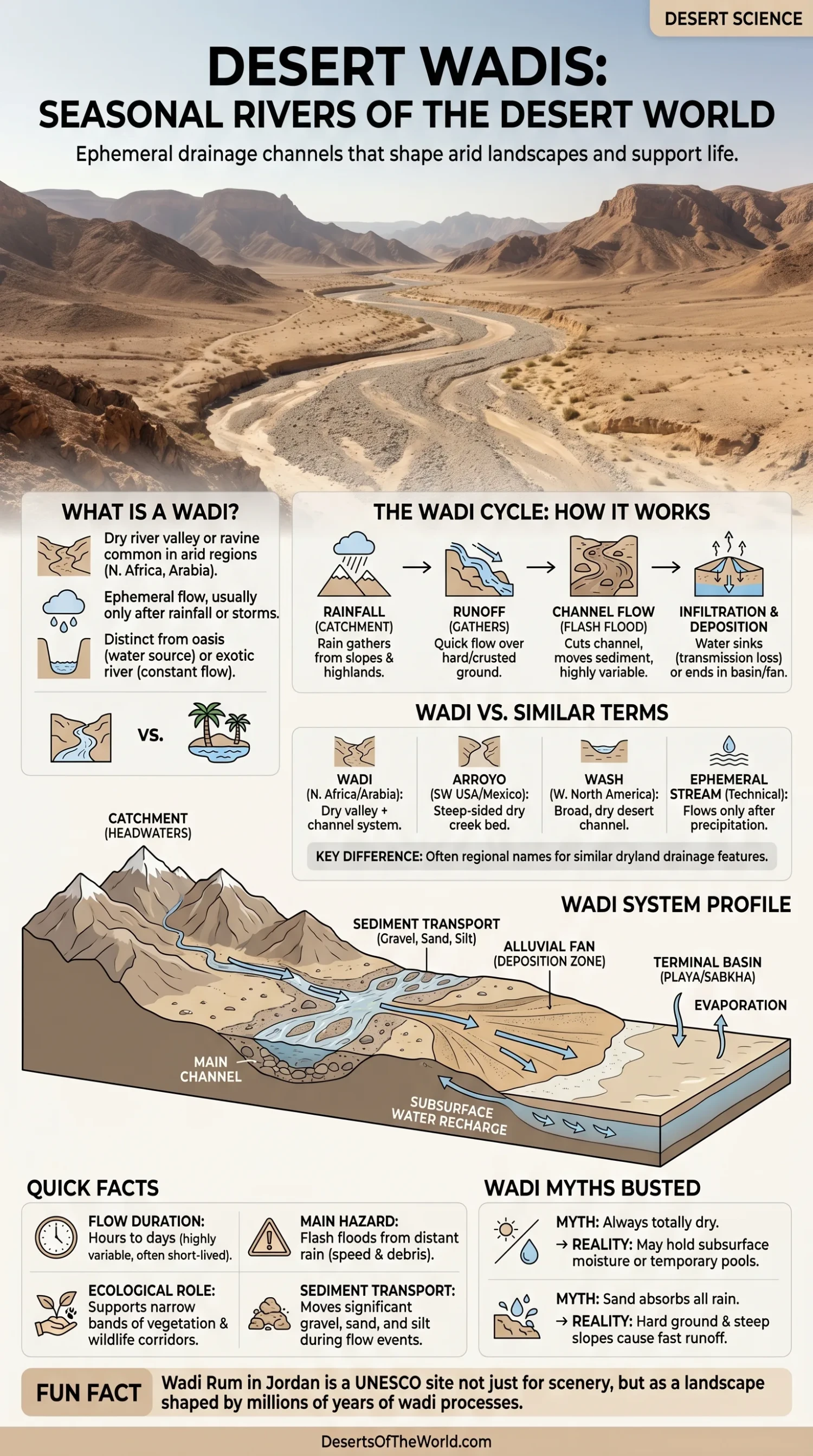
A wadi is a valley or channel in a dry region that usually stays dry until rain arrives. The word is widely used for desert riverbeds in North Africa, the Arabian Peninsula, and parts of Western Asia. In English-language geography, it often means a dry drainage channel that can briefly carry water after rain.
Not every dry valley is a wadi. A true wadi has a drainage function. It collects runoff from a catchment area and sends that water downslope, even if flow happens only for a few hours or a few days. Some wadis are broad and shallow. Others cut through sandstone, limestone, granite, or volcanic rock as narrow gorges.
The simple image is this: a wadi is a river with a long pause button. The channel is still there when the water is gone.
Why Wadis Matter in Desert Landscapes
Deserts are not waterless places. They are places where water is rare, uneven, and often brief. Wadis show this better than almost any other landform. They reveal how rainfall moves through a dry landscape before it disappears into sediment, evaporates, reaches a dry basin, or feeds underground water.
Wadis matter because they connect several desert processes at once:
- Runoff: rainwater moves quickly over hard, rocky, or crusted ground.
- Erosion: flowing water cuts channels, undercuts banks, and deepens gullies.
- Sediment Transport: gravel, sand, silt, and clay move through the drainage system.
- Deposition: water slows and drops sediment on alluvial fans, valley floors, playas, or sabkhas.
- Ecology: plants and animals often use wadis because moisture can linger below the surface.
Seen from above, many desert regions look like they are etched with pale veins. Those veins are often wadis, washes, and related drainage lines. Dry on most days, yes. Empty, no.
Wadi, Arroyo, Wash, and Ephemeral Stream
The same kind of landform can have different names depending on region and language. This creates confusion, especially for readers comparing the Sahara, Arabia, and the American Southwest.
| Term | Where It Is Commonly Used | General Meaning |
|---|---|---|
| Wadi | North Africa, Arabian Peninsula, Levant, English geography writing | A dry valley or riverbed that may carry water after rain. |
| Arroyo | Southwestern United States, Mexico, Spanish-speaking regions | A dry creek bed or steep-sided channel that carries runoff after storms. |
| Wash | Western North America | A dry desert channel shaped by occasional flowing water. |
| Ephemeral Stream | Hydrology and earth science | A stream that flows only in direct response to precipitation or snowmelt. |
| Intermittent Stream | Hydrology | A stream that flows during certain wet periods but not all year. |
The terms overlap, but they are not perfect twins. Wadi often carries a desert valley meaning, not only the watercourse itself. Ephemeral stream is more technical and focuses on flow timing. Wash and arroyo are common regional words for similar dryland channels.
How Wadis Form
Wadis form when water repeatedly follows the same low path through an arid or semi-arid landscape. Rain may be rare, but when it comes, it often arrives in short, intense bursts. On bare slopes and rocky ground, much of that water cannot soak in quickly enough. It runs downhill.
Rainfall Starts the Drainage Pulse
A wadi begins with a catchment. This may be a mountain slope, plateau edge, desert escarpment, canyon wall, or broad basin. Rain falls across that catchment and gathers into tiny rills. The rills join gullies. The gullies join a larger channel.
Then the wadi wakes up.
The flow may look muddy because desert runoff often carries fine sediment. It can also carry gravel, stones, broken plant material, and older channel deposits. In steep terrain, the water may move with force, especially where narrow rock walls funnel runoff into one corridor.
Dry Ground Does Not Always Absorb Water Fast
A common mistake is to imagine desert sand drinking up every drop. Some sand does absorb water, but deserts are not made only of loose sand. Many wadis cross bedrock, compacted soil, gravel pavement, clay-rich surfaces, salt flats, or crusted ground. These surfaces can shed water quickly.
Even where the channel bed is porous, flow may move faster than infiltration for a while. The result is a short river that may run strongly, then shrink, split, or vanish downstream as water seeps into sediment.
Erosion Cuts the Channel
When wadi flow returns again and again, it scours the bed and banks. The work is uneven. A single storm can cut a bank, expose older layers, move boulders, or open a fresh channel across a fan. Then years of dry weather may pass with little visible change.
This stop-start rhythm makes wadis different from many humid-region rivers. They do not always reshape the land slowly and steadily. Sometimes the land changes in short bursts.
The Main Parts of a Wadi System
A wadi is not only the dry bed visible from a road or trail. It belongs to a wider drainage system. Understanding the parts helps explain why a dry valley can suddenly carry water even when rain falls far away.
Catchment or Drainage Basin
The catchment is the land area that sends runoff into the wadi. In dry mountains, a catchment may include bare rock slopes, side gullies, terraces, and small tributary channels. Rain on any part of this basin can feed the main wadi.
Headwaters
The headwaters are the upper parts of the drainage system. They often begin in uplands, escarpments, or rocky slopes where rainfall is slightly higher than on the desert floor. In some regions, snowmelt from nearby highlands can also feed short-lived flow.
Main Channel
The main channel carries the combined runoff. It may be narrow and rocky in the upper valley, then wider and braided on flatter ground. Some channels have steep banks. Others look like shallow sandy corridors.
Alluvial Fan
Where a wadi leaves a canyon or mountain front and reaches a flatter plain, its flow slows down. Sediment drops out. Over time, this can build an alluvial fan, a fan-shaped deposit of gravel, sand, and finer material.
Alluvial fans are common in arid and semi-arid regions because streams often lose energy quickly when they exit confined valleys. A line of joined fans along a mountain front can form a broad apron known as a bajada.
Terminal Basin, Playa, Chott, or Sabkha
Some wadis do not reach the sea. They end in closed basins, dry lakes, salt flats, chotts, playas, or sabkhas. Water may pool briefly, evaporate, or sink into the ground. Fine sediment and salts can remain after the water disappears.
How Water Moves Through a Wadi
Wadi flow is often short-lived, but it is not random. Several processes decide how far the water travels and how long it lasts.
Runoff and Channel Flow
Runoff begins when rainfall exceeds the ground’s ability to absorb water. Steep slopes, bare rock, compacted surfaces, and sparse vegetation all help water gather faster. In a wadi channel, flow may appear as a shallow sheet, a braided stream, or a deeper muddy current.
Transmission Losses
As water moves downstream, some of it soaks into the channel bed and banks. Hydrologists often call these losses transmission losses. In drylands, they can be high because sandy and gravelly beds may act like a sponge beneath the channel.
This is one reason a wadi may flow strongly upstream and fade downstream without reaching a lake or sea. The water has not simply “disappeared.” Much of it may have entered the subsurface.
Groundwater Recharge
Some wadi water can help recharge shallow groundwater, especially where the channel bed is coarse and permeable. This does not mean every wadi contains easy water below the surface. Geology matters. So do sediment thickness, bedrock depth, rainfall pattern, and evaporation.
Still, in many dry regions, wadis have long been linked with wells, temporary pools, grazing routes, and narrow green corridors because subsurface moisture can last longer than surface flow.
Sediment: The Other River Inside a Wadi
A flowing wadi carries more than water. It moves the desert itself, grain by grain and stone by stone.
During strong runoff, a wadi can transport:
- Boulders and cobbles in steep channels or debris-rich floods.
- Gravel along the bed as rolling or bouncing particles.
- Sand in sheets, bars, and braided channel deposits.
- Silt and clay as suspended material that makes floodwater look brown or gray.
- Organic material such as leaves, branches, seeds, and plant fragments.
As the water slows, heavier material falls first. Finer sediment may travel farther into lower basins. This sorting helps build alluvial fans and layered channel deposits. In cut banks, these layers can show older flood events like pages in a desert notebook.
Wadis and Flash Floods
Flash flooding is one of the main natural hazards linked with wadis. The risk comes from speed, not only depth. A wadi can be dry under clear sky while rain falls upstream beyond a ridge or canyon bend. Water then travels down the channel and arrives with little warning.
Several conditions make wadis prone to fast flooding:
- Narrow valleys that funnel runoff into one route.
- Steep catchments with little vegetation cover.
- Rocky or crusted ground that sheds water quickly.
- Short, intense rainstorms over uplands.
- Loose sediment that can turn flow into a heavy, debris-rich current.
This does not make wadis negative landforms. It makes them active landforms. They are part of how deserts drain, erode, and renew small pockets of life after rain.
Wadis as Desert Life Corridors
Many desert plants use wadis because water lingers there longer than on open slopes. The channel may stay dry at the surface, while moisture remains below the gravel or sand. Roots can reach that hidden supply, especially in deeper channel deposits.
Vegetation in and near wadis often appears as narrow ribbons rather than wide forests. The pattern makes sense. Moisture follows the channel. Soil depth also tends to be greater there because the wadi collects sediment and organic material.
Common Ecological Roles
- Seed Movement: floodwater moves seeds along the channel.
- Temporary Grazing: fresh plant growth may appear after rain.
- Shade and Shelter: shrubs and trees in wadis can create cooler microhabitats.
- Wildlife Pathways: animals may follow wadis because they offer cover and occasional water.
- Soil Renewal: fine sediment can settle in pockets and support plant growth.
In a desert, a wadi can be a thin line of opportunity. Not lush everywhere. Not permanent everywhere. Still, life often gathers near it.
Wadis, Oases, and Exotic Rivers Are Not the Same
Wadis are sometimes confused with oases or large desert-crossing rivers. The differences are useful.
| Feature | Water Source | Surface Water Pattern | Desert Role |
|---|---|---|---|
| Wadi | Rainfall runoff, upland storms, occasional seasonal flow | Usually dry, flows briefly after rain | Drains catchments, moves sediment, supports narrow moisture zones |
| Oasis | Groundwater, springs, shallow water table, or managed water | May have more reliable water than surrounding desert | Creates a localized green area in arid land |
| Exotic River | Water from wetter regions outside the desert | Can flow through desert despite local aridity | Connects distant climates with dry basins and valleys |
| Playa or Chott | Runoff into closed basins | Often dry, may hold shallow temporary water | Receives fine sediment and salts after evaporation |
A wadi may feed an oasis, cross a dry basin, or end in a salt flat. Yet the wadi itself is best understood as a drainage channel or valley, not simply as a water source.
Famous Wadi Landscapes Around the Desert World
Some wadis are known for their geology, scenery, ecology, or long record of human use. The examples below show how varied these landforms can be.
Wadi Rum, Jordan
Wadi Rum is one of the best-known wadi landscapes. It lies in southern Jordan and is listed by UNESCO as a mixed natural and cultural World Heritage property. Its sandstone valleys, cliffs, narrow gorges, natural arches, and broad desert floors show how drainage incision and weathering can shape a desert valley system over long periods.
Wadi Rum also shows that wadis are not only channels for water. They can become whole desert corridors, with rock shelters, inscriptions, pastoral routes, and landforms shaped by water, wind, salt weathering, and time.
Saharan Wadis and Mountain Margins
Across parts of the Sahara, wadis drain from highlands and mountain regions such as the Atlas, Ahaggar, Tibesti, and nearby desert uplands. Some are linked to older wetter periods, while others still respond to modern storms. In northern Sahara regions, smaller wadis may drain toward chotts or closed basins.
These systems help explain why the Sahara is not a blank sand sea. It contains mountains, plateaus, gravel plains, dry valleys, salt basins, and buried drainage traces. Wadis stitch many of those surfaces together.
Arabian Peninsula Wadis
Wadis are common across the Arabian Peninsula, where dry mountains and plateaus feed short-lived drainage channels. In some places, wadis cut through rocky terrain and form deep valleys. In others, they spread across gravel plains and alluvial fans.
Some Arabian wadis hold pools after rain or support trees and shrubs along the channel. Others remain dry for long periods, showing only gravel beds and old flood deposits. Same landform family, different behavior.
Dry Washes of the American Southwest
The American Southwest uses terms like arroyo and wash more often than wadi, but the hydrologic idea is similar. Dry channels in deserts such as the Mojave, Sonoran, and Chihuahuan landscapes may carry sudden runoff after storms. Many alluvial fans in these regions were built by repeated short-lived flows leaving canyons and mountain fronts.
This comparison helps place wadis in a wider dryland pattern. Different languages, same desert lesson: water may be rare, yet it leaves strong marks.
What Wadis Reveal About Past Climates
Some wadi networks are active today. Others include traces of older drainage systems shaped when climate conditions were wetter than now. A wide dry valley, abandoned channel, or layered alluvial deposit can preserve clues about earlier rainfall, runoff, and sediment movement.
Desert scientists read these clues through:
- Channel shape and depth.
- Alluvial fan layers.
- Gravel size and sorting.
- Old lake beds or playa deposits downstream.
- Soil horizons and carbonate layers.
- Remote sensing images that reveal buried or faint drainage lines.
A wadi can act like a memory line across a desert. It may record both present-day storms and older phases of landscape development.
How to Read a Wadi Landscape
Wadis can look quiet, but their shapes tell a clear story when read carefully. A steep, narrow upper wadi suggests fast runoff and strong incision. A wider gravel channel suggests repeated spreading and shifting of flow. A fan at the valley mouth shows where water lost speed and dropped its load.
Clues in the Channel Bed
- Large rounded stones point to strong past flow able to move heavy material.
- Fine mud layers may mark slower water, temporary pooling, or overbank deposits.
- Braided small channels suggest shifting flow across loose sediment.
- Fresh cut banks can show recent erosion after a storm.
- Vegetation lines often mark where subsurface moisture lasts longer.
Clues Around the Wadi
Side slopes, terraces, and fans matter too. A wadi does not work alone; it belongs to the land around it. Terraces may mark older channel levels. Rock walls may focus runoff. Alluvial fans may show repeated pulses of deposition where the valley opens.
Small details, big story.
Wadis in Human Geography
For people living in drylands, wadis have often been natural routes, water-search zones, grazing corridors, and settlement edges. Their value comes from geography. A wadi is lower than the surrounding terrain, may hold deeper sediment, may gather runoff, and may keep moisture below the surface after rain.
That does not mean every wadi is safe or reliable. Some are dry for long stretches. Some flood quickly. Some contain water only in scattered pools after rain. The pattern depends on rainfall, geology, channel shape, and upstream basin size.
Still, wadis often stand out in desert maps because they organize movement. Valleys guide paths. Channels mark drainage. Vegetation marks moisture. In open arid land, those signals matter.
Common Misunderstandings About Wadis
A Wadi Is Not Always a River With Regular Seasons
The phrase “seasonal river” is useful for general readers, but many wadis are more accurately called ephemeral channels. Some flow during a rainy season. Others flow only after scattered storms, and not every year.
A Dry Wadi Is Not Inactive
A dry channel can still be part of an active drainage network. Its next flow may depend on a storm far upstream. Sediment layers, fresh gravel bars, and cut banks can reveal recent movement even when no water is visible.
Desert Floods Do Not Need a Wide River
A small wadi can carry fast runoff if the catchment is steep and rain is intense. Narrow canyons and dry washes can rise quickly because water is concentrated into limited space.
Sand Does Not Remove All Flood Risk
Some water soaks into sandy or gravelly beds, but infiltration takes time. Hard ground, bedrock, clay, desert pavement, and steep slopes can send runoff downstream faster than the land can absorb it.
Terms That Help Explain Wadis
| Term | Plain Meaning |
|---|---|
| Catchment | The land area that drains water into a channel. |
| Runoff | Water that flows over the land surface after rain. |
| Ephemeral Stream | A stream that flows only in direct response to precipitation or snowmelt. |
| Alluvium | Loose sediment deposited by running water, including sand, gravel, silt, and clay. |
| Alluvial Fan | A fan-shaped deposit where a stream leaves a narrow valley and spreads onto flatter land. |
| Transmission Loss | Water lost from a flowing channel into the bed and banks. |
| Playa | A dry lake bed or flat basin that may briefly hold water after runoff. |
| Sabkha | A salt-flat environment often linked with evaporation in arid coastal or inland settings. |
Frequently Asked Questions About Desert Wadis
Are Wadis Always Dry?
No. Many wadis are dry most of the time, but they may carry water after rainfall, during a wet season, or after runoff from nearby highlands. Some also contain temporary pools or subsurface moisture after surface flow ends.
Is a Wadi the Same as an Oasis?
No. A wadi is a valley or drainage channel. An oasis is a localized area where water is available near the surface, often from groundwater or springs. A wadi can help support oasis-like vegetation in some settings, but the two terms mean different things.
Why Can Wadis Flood So Quickly?
Wadis can flood quickly because rainfall may run off steep, rocky, compacted, or sparsely vegetated land. Narrow channels gather that runoff into a small space. Rain can also fall upstream, so the channel may rise even where the sky looks clear nearby.
Do Wadis Help Recharge Groundwater?
Some do. Water flowing through sandy or gravelly wadi beds can seep downward and recharge shallow groundwater. The amount depends on channel sediment, bedrock, rainfall intensity, flow duration, and local geology.
Where Are Wadis Most Common?
The term is most common in North Africa, the Sahara region, the Arabian Peninsula, and parts of Western Asia. Similar dryland channels occur in many other deserts, where they may be called arroyos, washes, dry creek beds, or ephemeral streams.
Sources
- U.S. Geological Survey – Desert Features (desert runoff, ephemeral streams, arroyos, wadis, and desert water movement)
- U.S. Geological Survey – Water Resources Glossary (definition of ephemeral stream and related hydrology terms)
- U.S. Geological Survey – EarthWord: Alluvial Fan (alluvial fan formation and sediment deposition)
- NOAA National Severe Storms Laboratory – Flood Basics (flash flooding in dry arroyos, canyons, and small streams)
- UNESCO World Heritage Centre – Wadi Rum Protected Area (Wadi Rum landforms, desert valleys, gorges, and protected landscape context)
- Encyclopaedia Britannica – Sahara Drainage (Saharan wadis, ephemeral streams, chotts, and desert drainage systems)