
Desert canyons look dry, but most were cut by water. The work is uneven: long quiet periods, then a storm, a flood pulse, a season of river flow, a fall of broken rock. Over geologic time, that stop-and-start rhythm can open a deep corridor through sandstone, limestone, granite, basalt, mudstone, or a stack of many rock layers.
In a desert, water does not need to be constant to reshape land. It only needs a route, a slope, loose sediment, and enough speed. A dry wash can become a brown, sediment-heavy stream for a short time. A river can cut down through an uplifted plateau. A narrow crack in sandstone can turn into a slot canyon. Slowly, then suddenly, the land is sliced open.
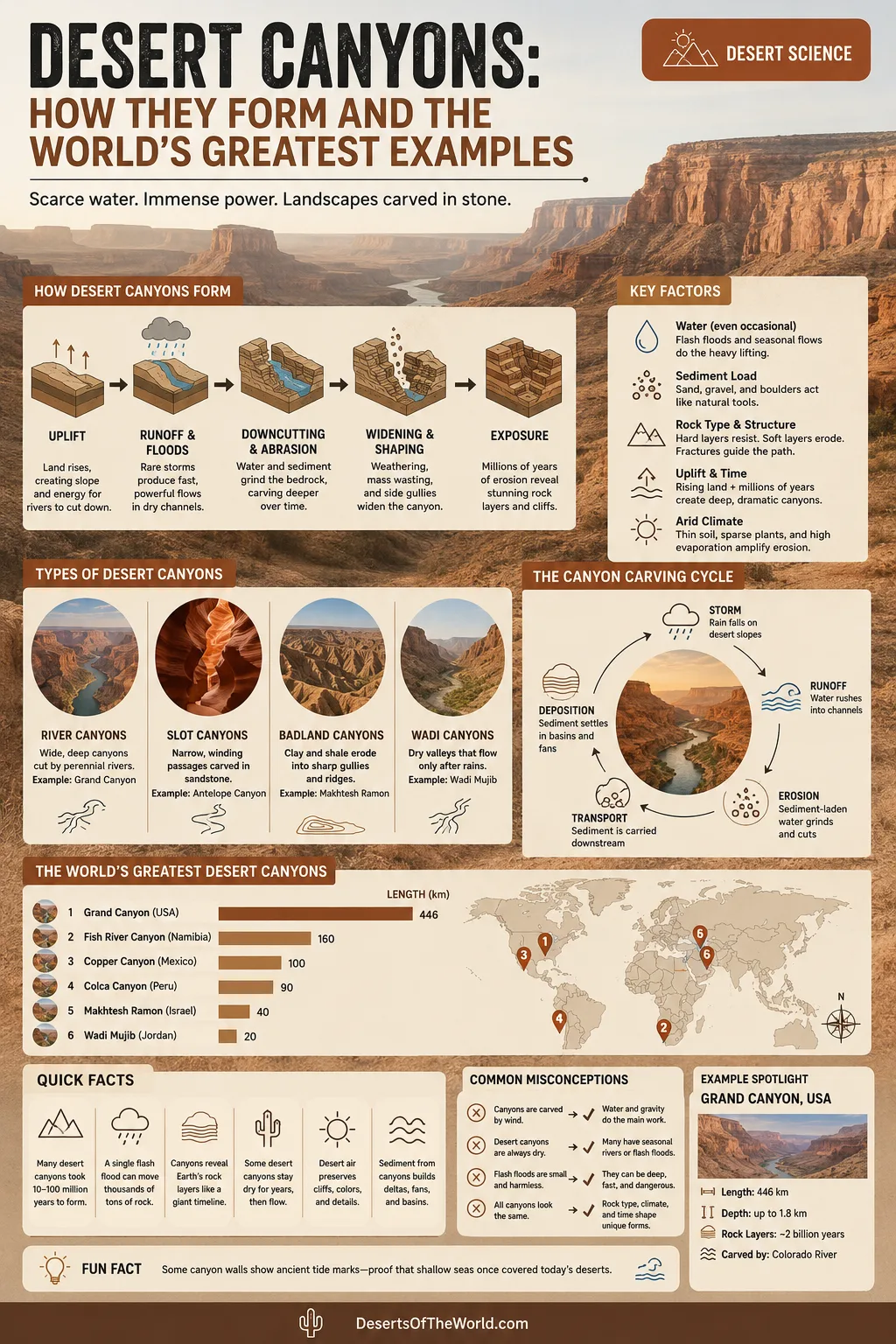
Desert Canyons: How They Form and The World’s Greatest Examples
A desert canyon is a steep-sided valley formed in an arid or semi-arid setting. Some lie inside true deserts. Others sit on dry plateaus, desert margins, or rain-shadow landscapes where evaporation is high and plant cover is thin. Their shared trait is simple: water is limited, but erosion can be intense when water moves.
| Feature | What It Means | Desert Canyon Link |
|---|---|---|
| Main Cutter | Moving water, usually rivers, flash floods, washes, wadis, and tributary streams. | Even dry channels can carry high-energy flow after storms. |
| Main Rock Types | Sandstone, limestone, shale, mudstone, granite, gneiss, basalt, and volcanic deposits. | Hard layers form cliffs; softer layers form slopes, ledges, alcoves, and side gullies. |
| Common Forms | Broad river canyons, narrow slot canyons, badland gullies, gorge systems, and wadi corridors. | Shape depends on water route, slope, fractures, and rock resistance. |
| Related Landforms | Mesas, buttes, terraces, alluvial fans, talus slopes, dry falls, plunge pools, and playas. | Canyons often connect uplands to desert basins where sediment is deposited. |
| Timescale | Many canyons form over millions of years, while individual floods can alter floors in minutes or hours. | The large shape is old; the details are often fresh. |
What Makes A Canyon A Desert Canyon?
The word “desert” can mislead. A desert canyon is not defined by sand dunes. Many have no dunes at all. The desert identity comes from climate, hydrology, bare rock, and sparse vegetation.
Several traits set desert canyons apart from humid-region valleys:
- Thin soil cover: Less plant matter and fewer roots leave bedrock exposed.
- Short, forceful runoff: Rain can rush over dry ground before it soaks in.
- Ephemeral channels: Washes, arroyos, and wadis may stay dry for long periods, then carry water suddenly.
- High sediment loads: Floodwater often moves sand, gravel, cobbles, and boulders that grind the canyon floor.
- Strong rock control: Joints, faults, bedding planes, and layer hardness strongly guide canyon shape.
- Visible geologic layers: Dry air and limited vegetation leave cliffs, ledges, and color bands easy to see.
This is why desert canyons can feel like open geology. Walls do not hide under thick forest. River terraces, fault lines, cross-bedded sandstone, volcanic caps, and old flood deposits often sit in plain view.
How Desert Canyons Form
Most desert canyons form through a chain of linked processes rather than one single event. A river may do the main downcutting. Flash floods may deepen side canyons. Gravity widens the walls. Wind may polish exposed surfaces, but it rarely carves the main canyon by itself.
Uplift Gives Rivers Cutting Energy
Canyons need relief. When a plateau, mountain block, or desert highland rises, streams gain slope. Slope gives moving water more energy, and that energy lets the channel cut downward into bedrock. This process is called incision or downcutting.
Uplift does not have to be fast. A landscape can rise slowly while a river keeps its course. The river then cuts deeper to maintain its path. The result may be an entrenched river canyon with steep walls and older meanders locked into rock.
The Grand Canyon is the best-known example. Colorado Plateau uplift raised rock layers high enough for the Colorado River and its tributaries to cut downward, exposing a thick stack of sedimentary rocks.
Storm Runoff Becomes A Short-Lived River
Deserts receive little rain overall, yet storms can be intense. When rain falls on bare slopes, slickrock, compacted soil, or crusted ground, runoff forms fast. Water gathers in rills, then gullies, then washes. In a narrow canyon, that flow is squeezed into a tight space.
Fast water carries sediment. Sand acts like sandpaper. Gravel and cobbles strike the channel floor. Boulders may roll during larger floods. Over many events, this moving load scours potholes, undercuts ledges, deepens slots, and clears loose debris from the canyon bed.
That is the desert canyon paradox: rare water can do concentrated work.
Abrasion Turns Sediment Into Tools
Water alone is not the full story. Sediment gives water cutting teeth. A clear stream can erode, but a sediment-rich flood can scrape, chip, and grind. In bedrock channels, this abrasion deepens grooves and potholes. In sandstone slots, it can smooth corners into flowing curves.
Some canyon floors contain rounded stones that have been moved, dropped, and moved again. They are not random decoration. They are part of the cutting system.
Rock Layers Decide The Wall Shape
Canyon walls often follow the personality of the rock. Hard sandstone, limestone, basalt, and gneiss can form steep cliffs. Softer shale, mudstone, or weathered volcanic ash may form slopes and benches. Where hard and soft layers alternate, the canyon wall becomes stair-stepped.
| Rock Or Structure | How It Affects Canyon Form | Common Result |
|---|---|---|
| Massive Sandstone | Allows narrow cuts along joints and bedding planes. | Slot canyons, smooth walls, alcoves, and domes. |
| Limestone | Can be cut by rivers and altered by solution along cracks. | Gorges, caves, undercut ledges, and pale cliffs. |
| Shale And Mudstone | Break down faster under wet-dry cycles. | Badland gullies, soft slopes, and crumbly side walls. |
| Granite And Gneiss | Resist erosion but fracture into blocks. | Deep rocky gorges with angular walls and boulder-filled floors. |
| Faults And Joints | Give water pre-cut lines of weakness. | Straight canyon segments, slots, side passages, and vertical cracks. |
Weathering Opens Cracks and Ledges
Weathering breaks rock in place. Erosion moves it away. In desert canyons, the two processes work together.
Daily heating and cooling can stress exposed rock. Salt crystals can grow in pores where water evaporates. Occasional frost can wedge open cracks in cold deserts and high plateaus. Biological weathering also matters where plants, lichens, or microbes occupy cracks and rock surfaces.
Once a block loosens, gravity takes over. Rockfall, debris flows, and talus buildup widen the canyon. Down below, the next flood may remove part of that debris and carry it toward a basin.
Sediment Leaves The Canyon Mouth
A canyon is not only an erosional feature. It is also part of a sediment conveyor. Material cut from the uplands travels down the channel. When the canyon exits a mountain front and the slope drops, water loses speed. Sand and gravel spread outward as an alluvial fan.
Alluvial fans are common at desert canyon mouths. They show that the canyon is connected to a larger dryland system: upland source area, narrow channel, fan, basin floor, and sometimes a playa where fine sediment and salts collect.
Why Deserts Keep Canyon Walls Sharp
Desert canyons often preserve steep, clean walls because the landscape is not softened by constant moisture. In wetter climates, slopes may round off faster under thick soil, root action, and regular mass movement. In dry regions, rock faces can remain exposed for long periods.
That does not mean desert canyons are frozen in time. They change, just not at a steady human pace. A quiet side canyon may look the same for years, then a single flood can move a boulder pile, cut a fresh gully, or scour a sandy floor down to bedrock.
Wind Shapes The Finish, Not The Main Cut
Wind matters in deserts, but it is often overrated as a canyon maker. Wind can sandblast exposed rock, move dunes against cliff bases, remove fine dust, and help polish surfaces. It can also help form tafoni, honeycomb weathering, and small alcoves in some sandstones.
The main canyon cut, though, usually comes from water moving downhill. The proof sits in the landforms: river terraces, potholes, plunge pools, polished flood channels, gravel bars, undercut banks, and alluvial fans. Wind leaves its signature. Water cuts the trench.
Types Of Desert Canyons
| Type | How It Forms | Where It Is Common |
|---|---|---|
| Broad River Canyon | A permanent or long-lived river cuts down through an uplifted plateau or highland. | Colorado Plateau, dry Andean valleys, interior desert margins. |
| Slot Canyon | Flash floods exploit narrow fractures in sandstone or similar bedrock. | Arizona, Utah, Jordan, and other sandstone desert regions. |
| Wadi Gorge | Ephemeral streams cut through desert mountains, often with short flood seasons. | Arabian deserts, North African drylands, Sinai, and Jordan. |
| Badland Canyon | Soft clay, mudstone, or ash-rich deposits erode into dense gullies and small ravines. | Desert basins, dry lake margins, and volcanic sediment areas. |
| Fault-Controlled Canyon | Water follows fractures, faults, or lowered blocks in the crust. | Rift margins, uplifted desert blocks, and tectonic basins. |
The World’s Greatest Desert Canyon Examples
The best desert canyons are not all great for the same reason. Some are deep. Some are wide. Some reveal rock history with rare clarity. Others show how short-lived floods can sculpt narrow stone corridors. Together, they explain the range of canyon forms found in dry landscapes.
| Canyon Or Canyon Area | Region | Desert Setting | Main Forming Force | Why It Stands Out |
|---|---|---|---|---|
| Grand Canyon | Arizona, United States | Colorado Plateau drylands | Colorado River incision, tributary erosion, plateau uplift | Huge scale, visible rock layers, and one of Earth’s clearest examples of arid-land erosion. |
| Fish River Canyon | Southern Namibia | Dry plateau near the Namib Desert margin | Tectonic trough development, river incision, resistant basement rocks | Africa’s large desert canyon, with a dry, rugged floor and steep erosional walls. |
| Antelope Canyon And Nearby Slot Canyons | Arizona, United States | Sandstone desert near Lake Powell | Flash floods cutting Navajo Sandstone | Narrow corridors, smooth sandstone walls, and textbook slot-canyon form. |
| Canyonlands | Utah, United States | Colorado Plateau canyon country | Green and Colorado river incision plus tributary washes | A maze of canyons, mesas, benches, spires, and joint-controlled sandstone passages. |
| Death Valley Canyons | California and Nevada, United States | Mojave and Great Basin desert transition | Storm runoff, mountain-front erosion, fault-basin relief | Golden Canyon, Mosaic Canyon, and Gower Gulch show how rare floods carve dry mountain fronts. |
| Wadi Rum Gorges | Southern Jordan | Arabian Desert sandstone landscape | Drainage incision, salt weathering, cliff retreat, and mass wasting | Narrow gorges, sandstone cliffs, natural arches, caverns, and broad sandy valley floors. |
| Colca Canyon | Arequipa Region, Peru | Dry Andean canyon and volcanic highland | River incision linked with Andean uplift and volcanic terrain | Very deep walls, strong elevation contrast, and a dry highland setting shaped by the Colca River. |
Grand Canyon, United States
Grand Canyon is the classic desert canyon because it combines length, width, depth, and rock exposure in one place. The canyon is 277 miles (446 km) long. In places it reaches up to 18 miles (29 km) wide, and its deepest sections reach about 6,000 feet (1,829 m) from rim to river.
Its formation is tied to the uplift of the Colorado Plateau and the cutting action of the Colorado River. The canyon did not simply “open” in one event. River incision, tributary erosion, slope failure, weathering, and changing base levels all played a role. The rock layers are much older than the canyon cut itself, which is why the walls read like a vertical archive of Earth history.
For desert-canyon study, Grand Canyon is useful because it shows several processes at once: main-stem river cutting, side-canyon growth, cliff-and-slope weathering, debris flows, terraces, and the link between uplift and erosion.
Fish River Canyon, Namibia
Fish River Canyon lies in southern Namibia, within a dry landscape of exposed rock, sparse plants, and intermittent flow. Official geologic material describes an upper canyon that is wider and shallower, and a lower canyon that is narrower and deeper, with depths commonly listed between 460 and 550 m in the lower section.
This canyon is not a simple river trench. Part of its origin is tied to tectonic subsidence along faults, while later incision by the Fish River cut into resistant rocks. In the dry season, the river may shrink to pools, but its channel still records the work of past flow. That contrast makes Fish River Canyon one of the clearest examples of a desert canyon where an intermittent river can still define a large landform.
Antelope Canyon and The Slot Canyons Of Northern Arizona
Antelope Canyon is a slot canyon in Navajo Sandstone near Page, Arizona. Its narrow, curving corridors show what happens when floodwater is forced through small openings in erodible sandstone. Sand carried by the water helps smooth the walls, while joints and bedding planes guide the channel.
Slot canyons are different from broad river canyons. They may be only a few feet wide in places, with walls that rise far above the floor. Their beauty comes from tight geometry: narrow light, curved walls, and polished stone. Their geology comes from concentration. Water that would spread across open ground is trapped in a narrow chute, so its energy focuses on a small area.
Antelope Canyon is also a reminder that a canyon can be dry at the surface and still belong to an active flood system.
Canyonlands, United States
Canyonlands National Park in Utah is canyon country on a wide scale. The Green and Colorado rivers cut through layered sedimentary rock, while side washes and tributary canyons drain toward them. Some canyons exceed 2,000 feet in depth, and the wider landscape includes mesas, benches, grabens, spires, and slickrock walls.
The area shows how a desert canyon network grows. A main river lowers the base level. Tributaries steepen and cut toward it. Joints and faults guide some passages. Hard layers create benches, while softer layers wear back. The result is not one canyon, but a connected terrain of cuts, walls, and rock islands.
Death Valley Canyons, United States
Death Valley is better known for salt flats and heat, yet its mountain fronts contain many canyons. Golden Canyon, Gower Gulch, Mosaic Canyon, and Titus Canyon show how desert relief, faulting, and storm runoff work together.
The floor of Death Valley is low, while nearby ranges rise steeply. That relief gives short desert streams enough slope to move sediment quickly during storms. In places, floodwater cuts through soft badland deposits. Elsewhere, it passes through polished narrows, breccia, marble, or older bedrock. The canyons may look still on a dry day. Geologically, they are not still.
Wadi Rum Gorges, Jordan
Wadi Rum is a protected desert landscape in southern Jordan, known for sandstone cliffs, narrow gorges, arches, caverns, ramps, and sandy valley floors. UNESCO describes the protected area as 74,000 hectares and notes its range of narrow gorges and towering cliffs.
Its canyon forms are shaped by more than flowing water. Drainage incision cuts valleys and gorges, while salt weathering, cliff undercutting, mass wasting, and wind-blown sand help shape the sandstone surfaces. Wadi Rum is a strong example of a desert canyon landscape where vertical rock walls and broad sandy floors sit side by side.
Colca Canyon, Peru
Colca Canyon sits in southern Peru’s dry Andean highlands, in a landscape connected with volcanic terrain, steep relief, and river incision. It is not a classic lowland sand desert canyon. It belongs better to the dry highland and desert-margin category, where aridity, uplift, and deep river cutting meet.
UNESCO’s geopark material describes the Colca Canyon as reaching depths of more than 3,400 m. The canyon’s scale comes from the river cutting into uplifted Andean terrain. Elevation changes are large, and the canyon walls expose a long geologic record of volcanic, tectonic, and erosional processes.
How To Read A Desert Canyon Wall
A canyon wall can be read like a field page. Not every wall shows every feature, but several clues appear again and again:
- Horizontal bands: Different sedimentary layers, often deposited in seas, rivers, lakes, dunes, or floodplains before the canyon existed.
- Cross-bedding: Angled layers inside sandstone, often linked to old dunes or migrating sand bars.
- Vertical cracks: Joints or fractures that guide runoff, slot formation, and rockfall.
- Benches and cliffs: Alternating soft and hard layers responding differently to erosion.
- Dark surface coating: Desert varnish, a thin mineral film common on exposed rock in dry regions.
- Terraces: Older river or floodplain levels left above the modern channel after downcutting.
- Talus slopes: Broken rock gathered at the base of cliffs after weathering and rockfall.
Once these clues become familiar, a canyon stops looking like one solid cut. It becomes a record of deposition, uplift, water flow, weathering, collapse, and sediment transport.
Why Some Desert Canyons Are Narrow and Others Are Wide
Canyon width depends on the balance between downward cutting and wall retreat. If water cuts down faster than walls crumble back, the canyon stays narrow. If slopes weather and collapse faster, the canyon widens.
Several controls matter:
- Rock strength: Massive sandstone and limestone can hold steep walls; weak mudstone widens into slopes.
- Fracture spacing: Closely spaced joints make rock easier to break apart.
- Flood frequency: Repeated floods can clear debris and keep a narrow channel open.
- Relief: Greater height difference gives water more energy for incision.
- Climate swings: Wetter past periods may have supplied more runoff than the modern desert climate does.
- Base level: If the main river or basin floor drops, tributaries may cut deeper to match it.
This explains why nearby canyons can look different. One may be a wide amphitheater with badland slopes. Another, cut into better-jointed sandstone, may be a tight slot. Same region. Different rock and drainage behavior.
Common Questions About Desert Canyons
Are Desert Canyons Made By Wind?
Wind can shape details, especially on exposed sandstone. It can remove fine sediment, polish surfaces, and move sand into ramps or dunes. Yet most desert canyons are cut mainly by water: rivers, floods, washes, and runoff carrying sediment downhill.
How Can A Dry Canyon Still Be Active?
A canyon does not need daily water to be active. In deserts, erosion may happen in pulses. A wash can stay dry for months, then move sediment during one storm. Rockfall can occur after temperature stress or after a rare wet period. Active, in this case, means the landform still changes when the right conditions arrive.
Why Do Slot Canyons Form So Smoothly?
Slot canyons form where water is forced through narrow passages, often in sandstone. Floodwater carries sand and gravel that abrade the walls. The flow curves, swirls, and rebounds inside tight spaces, smoothing edges over time. The result can look carved by hand, but the tools are water, sediment, and gravity.
Why Are Some Canyon Walls Layered?
Layering usually comes from older environments that existed before the canyon. A sandstone layer may record dunes. A limestone layer may record a shallow sea. Mudstone may record floodplains or quiet water. The canyon cut exposes these layers after uplift and erosion remove the surrounding rock.
Do Desert Canyons Keep Getting Deeper?
Some do. A canyon can deepen if the river still has enough slope and sediment-moving energy. Others widen more than they deepen, especially where base level is stable or where debris shields the bedrock floor. Many desert canyons change in small pulses rather than at a steady pace.
Desert Canyon Terms Worth Knowing
| Term | Plain Meaning | Why It Matters |
|---|---|---|
| Incision | Downward cutting by a river or stream. | It creates depth. |
| Abrasion | Grinding by sediment carried in moving water. | It scours channels, potholes, and slot walls. |
| Ephemeral Stream | A channel that carries water only after rain or during short wet periods. | Many desert washes and wadis work this way. |
| Alluvial Fan | A fan-shaped deposit at the mouth of a canyon. | It records sediment leaving the canyon. |
| Base Level | The lower limit a stream cuts toward, such as a river, lake, sea, or basin floor. | A drop in base level can trigger deeper canyon cutting. |
| Joint | A natural crack in rock without major movement along it. | Joints often guide slot canyons and straight cliff lines. |
| Talus | Broken rock piled below a cliff. | It shows wall retreat and rockfall activity. |
Sources
- National Park Service — Grand Canyon Geology (Colorado Plateau uplift, Colorado River erosion, and exposed rock layers)
- National Park Service — Grand Canyon Questions (Grand Canyon length, width, and depth figures)
- U.S. Geological Survey — Geology of Grand Canyon National Park (river incision and canyon age context)
- National Park Service — Canyonlands Geology (Green and Colorado rivers carving layered canyon country)
- National Park Service — Death Valley: Then and Now (slow desert erosion and flood-event canyon change)
- Geological Survey of Namibia — Fish River Canyon (Fish River Canyon depth, upper and lower canyon form, and erosional origin)
- UNESCO — Wadi Rum Protected Area (narrow gorges, sandstone cliffs, arches, caverns, and desert setting)
- UNESCO — Colca y Volcanes de Andagua (Colca Canyon depth and volcanic dryland setting)