
Deserts look dry, open, and still, but a short storm can turn a quiet wash into a fast channel of muddy water. Desert flash floods happen suddenly because rain falls faster than dry ground, rock, clay, and narrow drainage channels can absorb or carry it. The storm may be overhead. It may also be miles away, hidden behind a ridge or outside the visible sky. By the time the water arrives, the desert floor can change in minutes.
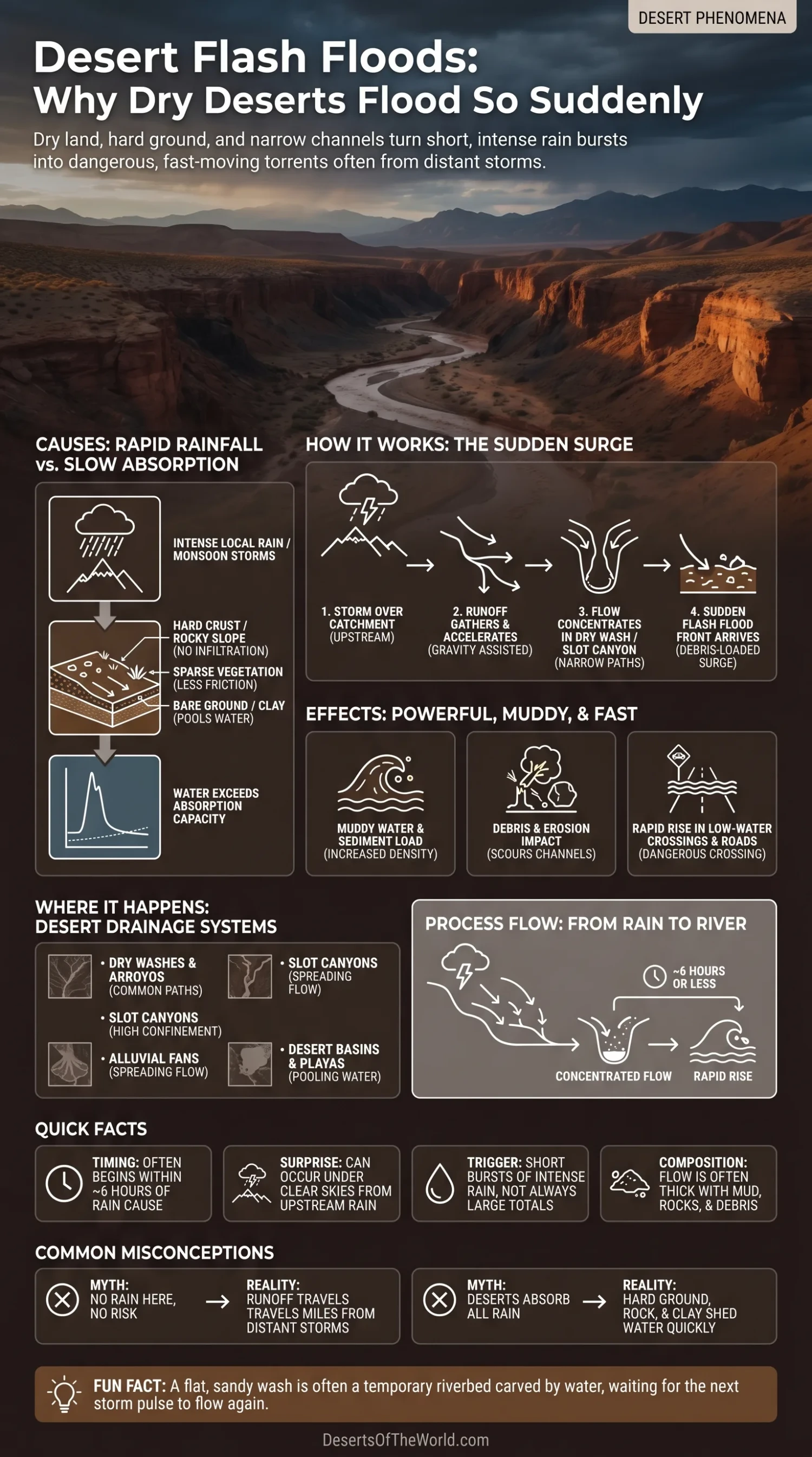
| Feature | What It Means in Deserts |
|---|---|
| Main Trigger | Short bursts of intense rain, often from thunderstorms, monsoon storms, or moisture moving over dry basins. |
| Common Pathways | Dry washes, arroyos, wadis, slot canyons, gullies, alluvial fans, dirt roads, and low-water crossings. |
| Timing | A flash flood is commonly defined as a rapid flood that begins within about 6 hours of the cause, though desert washes can react much faster. |
| Why It Feels Surprising | The ground may be dry, the local sky may look clear, and the channel may have carried no water for months or years. |
| Landscape Clue | A flat, sandy wash is not empty land. It is often a temporary riverbed that carries runoff during storm events. |
What Is a Desert Flash Flood?
A desert flash flood is a fast rise of water across land that is normally dry. It often moves through ephemeral channels, meaning channels that carry water only after rain or seasonal runoff. In North America, these channels may be called washes or arroyos. In North Africa, the Middle East, and parts of Asia, the word wadi is often used.
The process begins when rain falls over a dry catchment, runoff gathers, and water moves downhill into the lowest available path. In desert country, that path is often a canyon floor, gravel wash, shallow basin, or road crossing a natural drainage line.
A channel can remain dry for months or years and still carry fast-moving water when the right storm reaches its catchment.
Why Dry Deserts Flood So Suddenly
Deserts receive little average rainfall, but that does not mean every rain event is gentle. Some storms are brief, local, and intense. When heavy rain falls on steep, sparsely vegetated, rocky, or hardened ground, much of the water can move across the surface instead of soaking into the soil.
Rainfall Can Arrive Faster Than the Ground Can Take It In
Dry desert soil does not always absorb water quickly. Some loose sandy surfaces allow good infiltration, but many desert areas also contain compacted soil, clay-rich layers, caliche, exposed bedrock, desert pavement, or biological soil crust. These surfaces can limit the rate at which water enters the ground.
Once rainfall exceeds the infiltration rate, excess water becomes surface runoff. On sloping ground, that runoff quickly moves toward gullies and drainage channels.
Steep Slopes Send Runoff Down Fast
Many deserts sit beside mountains, mesas, escarpments, and rocky highlands. A storm over higher ground can send water into valleys and basins below.
This is why a desert flood can arrive where no rain is falling. The storm may be over a ridge, plateau, or mountain catchment several miles upstream. Someone standing farther downstream may have clear skies overhead while runoff is already moving through the drainage system.
Vegetation Is Often Too Sparse to Slow the Flow
Plants can slow runoff. Leaves reduce raindrop impact, roots help stabilize soil, and stems interrupt shallow surface flow. In many deserts, vegetation is scattered. Bare ground, gravel, and exposed rock give runoff fewer obstacles.
Faster runoff can carry more sediment and increase erosion as water moves toward channels.
Dry Channels Are Already Shaped Like Waterways
A wash may look like a convenient walking route because it is open and often smoother than the surrounding terrain. Its shape comes from repeated water flow.
When rainwater gathers from a large catchment, it naturally funnels into these low channels. A dry wash remains part of the drainage system even when no water is visible.
The Desert Drainage System: Washes, Arroyos, Wadis, and Fans
Desert floods follow the shape of the land. Water moves from higher ground toward low areas, from small rills into gullies, from gullies into washes, and from washes onto fans or basin floors.
Washes and Arroyos
Washes and arroyos are normally dry streambeds. They may carry water only after rain, but their banks, gravel bars, and scoured floors show repeated flow. Some are shallow and wide. Others cut deeply into soft sediment.
During a flood, these channels can carry muddy water, sand, gravel, branches, and rocks. The water often contains far more sediment than a typical permanent river.
Wadis
Wadis are dry valleys or temporary channels common in desert and semi-desert regions across North Africa, the Arabian Peninsula, and parts of Southwest Asia. Some remain dry through long periods, then carry water suddenly after storms.
The regional terminology changes, but the drainage process is similar: runoff concentrates in a channel that is dry for much of the year.
Slot Canyons
Slot canyons are narrow, steep-sided channels. They are especially sensitive to flash flooding because water has little room to spread out. A flow that remains shallow in a broad wash can become deeper and faster when confined inside a narrow canyon.
Escape routes can also be limited because steep canyon walls restrict movement away from the channel floor.
Alluvial Fans
An alluvial fan forms where water leaves a steep channel and spreads onto flatter ground, depositing gravel, sand, and finer sediment. Many desert roads, settlements, and developed areas occupy fan surfaces because the terrain is broad and relatively flat.
Yet alluvial fans are built partly by repeated runoff and sediment movement. Floodwater may split into several shallow channels, shift course, or spread across areas where no permanent channel is obvious.
Why a Small Amount of Rain Can Matter
Desert flood risk is not controlled by rainfall total alone. Rainfall rate matters. The location of the storm, its duration over one catchment, ground conditions, slope, and drainage shape also affect runoff.
| Condition | Effect on Flooding |
|---|---|
| High Rainfall Rate | Water falls faster than the surface can absorb it, creating quick runoff. |
| Hard or Crusted Ground | Less water enters the soil, so more water moves across the surface. |
| Bare Rock | Rain runs off almost immediately, especially on slopes and canyon walls. |
| Sparse Vegetation | Flow meets less resistance and can gather speed. |
| Narrow Channels | Water depth and speed can rise quickly because the flow is confined. |
| Large Upstream Catchment | Rain from a wide area concentrates into one drainage line downstream. |
The U.S. Geological Survey notes that desert storms can occasionally deliver intense rainfall. One documented Sahara event produced 44 millimeters of rain in 3 hours, while large Saharan storms can reach rainfall rates of about 1 millimeter per minute. These are not ordinary daily conditions, but they show why a dry climate can still experience rapid runoff.
The Role of Thunderstorms and Monsoon Moisture
Many desert flash floods come from convective thunderstorms. These storms can release intense rain over a small area while nearby ground remains dry. In places such as the Sonoran, Mojave, Chihuahuan, Arabian, and Sahara margins, seasonal moisture can produce short periods of heavy rainfall.
In the desert Southwest of the United States, summer monsoon moisture often helps thunderstorms develop over mountains and elevated terrain. Runoff generated there may later move into lower desert basins.
Why Storm Location Matters More Than Local Rain
A person standing in a dry wash may see no storm overhead while heavy rain is falling elsewhere in the same drainage basin.
Runoff follows the connected catchment.
If a thunderstorm drops heavy rain upstream, water can move through branching channels and arrive downstream as a rapid rise. Changes in water sound, sediment, floating debris, or flow in previously dry channels may accompany the arrival, but some floods develop with little local warning.
Why Deserts With Sand Still Flood
It is easy to assume sand should absorb all rain. Some sandy surfaces do allow rapid infiltration near the surface, yet deserts are not made only of loose dune sand. Many desert landscapes contain gravel plains, bedrock slopes, clay pans, salt flats, hard crusts, and compacted tracks.
Even where sand absorbs water, several conditions can still produce flooding:
- Rain may exceed infiltration speed. Water begins moving across the surface before the ground can absorb it.
- Subsurface layers may block downward movement. A shallow hardpan or clay layer can keep water near the surface.
- Runoff may come from rockier ground nearby. A sandy wash can receive water generated on less permeable slopes.
- Channels concentrate flow. A broad catchment can deliver runoff into one narrow drainage line.
Sand can absorb water, but infiltration varies by location, soil depth, rainfall intensity, and the material beneath the surface.
Flood Waves, Debris, and Muddy Water
Desert flash floods often carry more than water. They can move sediment, gravel, logs, cactus pieces, branches, and rocks loosened from canyon walls or channel banks. The flow may look brown, gray, or reddish depending on local geology.
This sediment load affects how the water behaves. Muddy water can hide holes, loose sediment, uneven stones, and fast current beneath the surface.
Why the First Wave Can Carry So Much Material
Dry channels accumulate sand, pebbles, plant matter, and collapsed bank material between flood events. When runoff returns, the first strong pulse can pick up and transport some of this stored material.
In narrow channels, that material may arrive with muddy water and moving gravel before the flow settles into a more regular pattern.
Desert Landscapes That Flood Fast
Not every desert surface responds to rainfall in the same way. Rapid runoff is especially common where steep slopes, exposed rock, sparse vegetation, narrow drainage, and sizable upstream catchments occur together.
Rocky Canyons
Rocky canyons shed rainfall quickly because exposed stone absorbs little water. Water runs down walls, ledges, and side gullies before collecting on the canyon floor. Narrow channels can then concentrate that runoff.
Dry Washes Across Basin Floors
Wide washes may look less confined than slot canyons, but they can still carry fast flow and sediment. Their broad beds can contain several smaller channels that join or spread during larger runoff events.
Playas and Closed Basins
Some deserts drain inward rather than toward the sea. Rainwater may collect in low basins, forming temporary shallow lakes on playas or salt flats. These events often behave differently from fast canyon floods, but roads crossing playas can become submerged, soft, or impassable.
Alluvial Fans Near Mountain Fronts
Fans can receive sudden runoff from steep canyons above them. Because channels on fans can shift, water may spread, split, and rejoin across different parts of the fan surface.
Why Flash Floods Are Hard to Predict in Deserts
Forecasting desert flash floods is difficult because storms can be small in area and develop quickly. One canyon may receive heavy rainfall while another nearby remains almost dry. Rain gauges can miss the strongest part of a storm, and mountainous terrain can make radar observation more difficult.
Hydrologists and weather forecasters also have to consider slope, soil, vegetation, drainage shape, previous rainfall, and the size of the upstream catchment. Desert basins can respond unevenly even during the same weather system.
Official warnings therefore often focus on washes, small streams, canyons, low-water crossings, and poorly drained areas where runoff can collect.
Desert Flash Floods and Landform Change
Flash floods also shape desert terrain. Although flowing water may be absent for long periods, short runoff events can move large amounts of sediment.
A strong flood can:
- Cut new channels into soft sediment.
- Deepen arroyos and gullies.
- Move gravel and rocks downstream.
- Spread sediment across alluvial fans.
- Leave debris lines on canyon walls and shrubs.
- Fill temporary pools used by desert organisms.
Gravel bars, eroded banks, fresh sediment layers, and fan deposits preserve evidence of earlier flood events long after the surface dries.
Physical Clues of Past Flooding in a Desert Wash
A dry wash often preserves evidence that water has moved through it before. These features do not predict when another flood will occur, but they identify terrain shaped by runoff.
- Rounded gravel: Stones worn and moved by repeated flow.
- Fresh cut banks: Sharp sediment edges produced by recent erosion.
- Debris caught in shrubs: Material deposited above the normal dry channel floor.
- Ripple marks or mud cracks: Evidence of shallow water, sediment movement, or drying mud.
- Multiple small channels: Braided drainage that can spread across a broad wash.
- Scoured canyon floors: Surfaces repeatedly cleared by moving water and sediment.
A surface shaped as a drainage channel can carry water again even when it has been dry for a long period.
Common Misunderstandings About Desert Flash Floods
“It Is Not Raining Here, So There Is No Flood Risk”
Local rain is only one part of the drainage picture. Runoff from distant storms can travel downstream through washes and canyons. Clear skies at one location do not rule out rainfall farther upstream.
“The Desert Is Too Dry to Flood”
Dry terrain can produce rapid runoff. Hard ground, sparse vegetation, steep rock surfaces, and well-defined drainage channels can move rainfall quickly toward low areas.
“A Wide Wash Cannot Flood Quickly”
A wide wash gives water more room to spread, but it can still carry fast flow, sediment, and debris. Roads often cross washes because they form natural low points, which means those same locations can collect runoff during storms.
“Only Large Storms Matter”
A large regional storm can affect many catchments, but a smaller intense storm can also produce fast runoff if it remains over steep or poorly absorbent terrain.
Desert Regions Where This Pattern Is Common
Desert flash flooding occurs across many drylands. Rainfall seasons, drainage terminology, and landforms vary, but runoff repeatedly follows the same basic physical controls.
| Region | Common Landforms | Typical Flood Context |
|---|---|---|
| American Southwest | Washes, arroyos, slot canyons, alluvial fans | Summer monsoon storms, local thunderstorms, runoff from higher terrain |
| Sahara Margins | Wadis, rocky plateaus, dry basins | Rare intense storms and runoff through normally dry channels |
| Arabian Desert | Wadis, gravel plains, mountain-front fans | Seasonal storms and runoff from rugged uplands |
| Atacama and Andean Drylands | Alluvial fans, steep quebradas, dry valleys, salt basins | Unusual rainfall, highland runoff, winter frontal systems, and local channel response |
| Australian Interior | Ephemeral creeks, claypans, desert channels | Storm runoff, tropical moisture reaching inland basins, and temporary flow |
July 2026 Flooding in Chile’s Atacama Region
A July 2026 weather event in northern Chile provides a recent example of how normally dry terrain can react when sustained or intense rainfall reaches desert-edge drainage systems.
On 18 July 2026, Chile’s National Service for Disaster Prevention and Response (SENAPRED) reported heavy rainfall associated with a wider frontal system affecting central and northern parts of the country. A Red Alert was declared for Huasco Province in the Atacama Region as emergency agencies responded to rainfall and changing conditions around rivers and quebradas.
By 19 July 2026, response work in Huasco Province was focused on restoring road access toward Alto del Carmen and San Félix. SENAPRED reported flooding, isolated communities, and sectors affected by the activation of quebradas, with machinery working to clear Route C-46 and other transport links.
The location matters. The reports concern Huasco Province and affected parts of the Atacama Region; they do not describe the entire Atacama Desert as flooded. The Atacama extends far beyond the affected drainage basins, and many hyper-arid areas experienced a different weather situation.
The event fits the physical pattern seen in desert flash flooding. Quebradas that remain dry or carry little water during ordinary conditions can collect runoff from surrounding slopes when heavy rainfall reaches their catchments. Water and sediment then concentrate in established drainage lines, while roads following or crossing those channels can lose connectivity.
What Desert Flash Floods Reveal About Drylands
Low annual rainfall does not mean flowing water has little influence on desert landscapes. Much of that influence is concentrated into short events separated by long dry periods.
During rainfall, connected slopes, gullies, washes, quebradas, wadis, alluvial fans, playas, and basins form a drainage network. Once the event ends, many channels return to dry conditions, while erosion and deposited sediment remain visible.
Frequently Asked Questions
Why Do Deserts Flood If They Receive Little Rain?
Deserts flood because some rain arrives in intense bursts. When rain falls faster than the ground can absorb it, runoff moves into washes, arroyos, wadis, canyons, quebradas, and low basins. Low annual rainfall does not prevent short periods of heavy runoff.
Can a Flash Flood Happen Under Clear Skies?
Yes. A storm upstream can send water into a dry channel downstream even if the sky directly overhead is clear. This can happen where mountain catchments and long drainage networks collect rainfall from areas outside the observer’s view.
Are Sandy Deserts Safe From Flash Floods?
No. Some sand absorbs water efficiently, but deserts also contain rock, clay, crusted soil, gravel plains, hardpan, and compacted surfaces. Runoff generated on nearby slopes can also enter sandy washes.
What Is the Difference Between a Wash, an Arroyo, a Wadi, and a Quebrada?
Wash and arroyo are commonly used for temporary or normally dry channels in parts of North America. Wadi is widely used in North Africa, the Arabian Peninsula, and nearby regions. In Spanish-speaking drylands, quebrada can refer to a ravine, gorge, or drainage channel. Each can become a pathway for runoff depending on local terrain.
Why Are Slot Canyons So Sensitive to Flash Flooding?
Slot canyons are narrow and steep-sided, so water has little room to spread. Runoff entering the canyon can become deeper and faster while carrying mud, gravel, rocks, and other debris.
Did the Entire Atacama Desert Flood in July 2026?
No. Official reports described rainfall, activated quebradas, flooding, isolation, and transport disruption in affected parts of Chile’s Atacama Region, particularly Huasco Province. The event should not be described as flooding across the entire Atacama Desert.
Sources
- NOAA National Weather Service – Flash Flood Glossary (flash flood definition and timing)
- NOAA National Severe Storms Laboratory – Flood Basics (heavy rainfall, runoff, and flash-flood processes)
- National Weather Service – Flood Related Hazards (rapid flooding, drainage channels, and flood hazards)
- National Weather Service Phoenix – Monsoon Safety (desert storms, washes, and runoff from distant rainfall)
- National Park Service – Zion National Park Flash Floods (slot canyons, drainage basins, and upstream rainfall)
- National Park Service – Joshua Tree National Park Rain Events and Flash Floods (desert washes, roads, canyons, and sudden runoff)
- U.S. Geological Survey – Desert Features (desert rainfall, wadis, arroyos, ephemeral streams, and Sahara rainfall examples)
- U.S. Geological Survey – Flood-Inundation Mapping of a Steep, Gravel Desert Stream in Death Valley National Park (desert runoff, channel response, and short flood peaks)
- SENAPRED – Response to the July 2026 Frontal System, 18 July 2026 (heavy rainfall response and Red Alert for Huasco Province in the Atacama Region)
- SENAPRED – Huasco Response Update, 19 July 2026 (activated quebradas, flooding, isolated communities, and restoration of access toward Alto del Carmen and San Félix)