
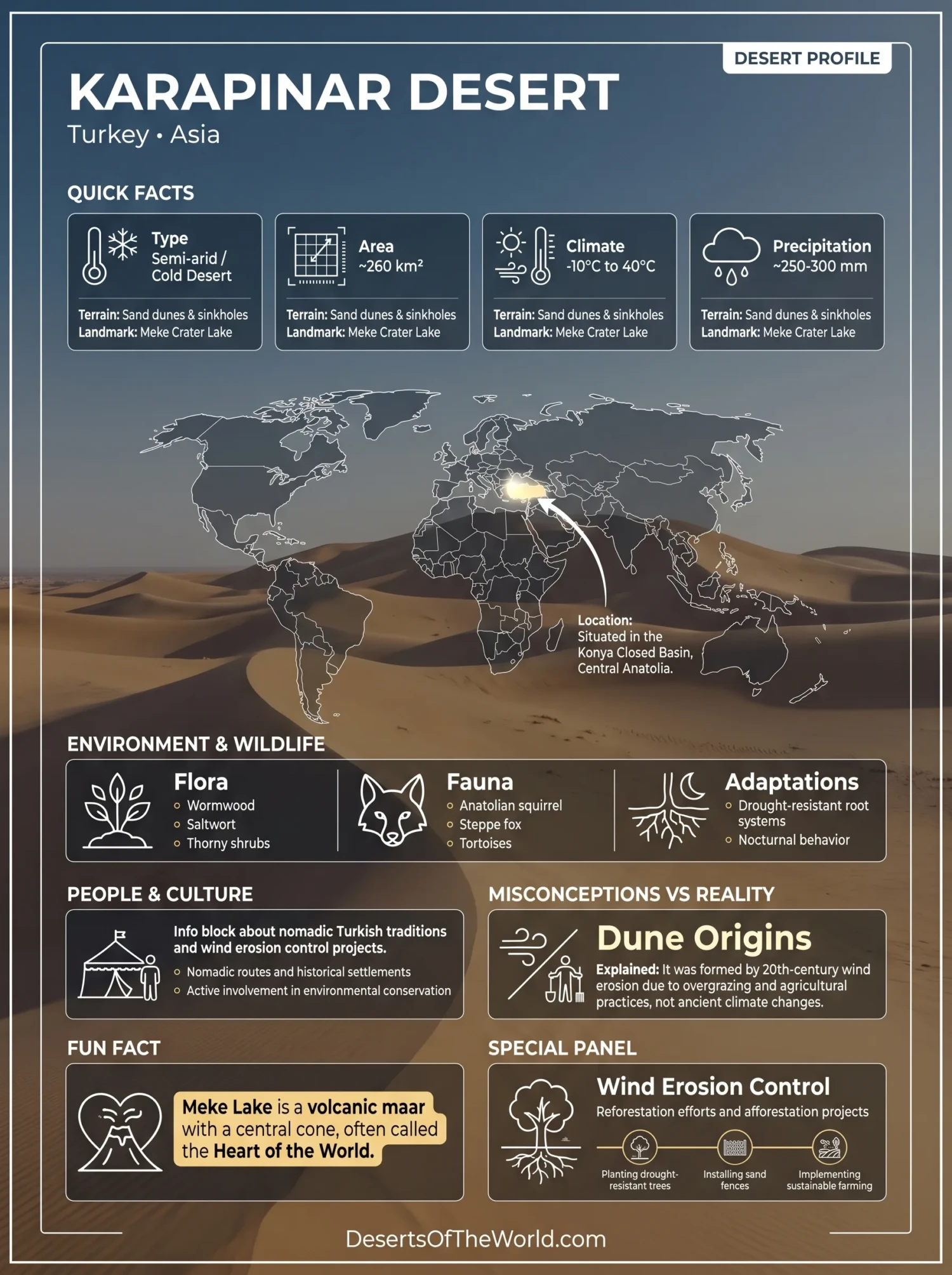
Location & Continent
Continent: Asia
Country: Turkey
Coordinates: 37°42′N, 33°33′E
Karapınar Desert – Map & Street View
Photos of the Karapınar Desert

Physical Features
Area: ~260 km² (Turkey’s only true desert region)
Length: ~35 km (east–west)
Width: ~8–10 km (north–south)
Elevation: ~990–1,000 m above sea level (part of the Konya Closed Basin)
Climate & Precipitation
Temperature: Summer highs can exceed 40 °C; winters drop below −10 °C
Precipitation: ~250 mm annually, mostly in spring and autumn; strong evaporation and wind erosion dominate the local climate
Ecological Features
Ecozone: Palearctic (semi-arid steppe and cold desert transition zone)
Biome: Temperate steppe and semi-desert
Ecoregions: Central Anatolian steppe, Konya Closed Basin, Karapınar dune field and sinkhole area
Flora & Fauna
Flora: Sparse halophytic (salt-tolerant) and xerophytic vegetation such as wormwood (Artemisia), saltwort (Salsola), steppe grasses, and tamarisk along dry channels
Fauna: Anatolian ground squirrel, steppe fox, hares, reptiles (agamas, tortoises), migratory birds including larks, harriers, and sandgrouse near wetlands such as Meke Lake
Geology & Notable Features
Geology: Formed by intense wind erosion and desertification due to overgrazing and deforestation in the mid-20th century; composed of volcanic ash, dune sands, and loess deposits over the Konya Basin’s lacustrine sediments
Notable Features: Meke Crater Lake (a volcanic maar with a central cone), Acıgöl Salt Lake, large moving dunes stabilized by reforestation projects, sinkholes caused by groundwater loss, and the Karapınar Wind Erosion Control Project—Turkey’s major desert reclamation success
Introduction to the Karapınar Desert
The Karapınar Desert, located in Turkey’s Central Anatolia region, presents a unique desert landscape characterized by its arid climate and distinct geographical features. Known for its striking beauty and ecological significance, this desert has attracted both researchers and adventurers alike. In this article, we will explore the geographical aspects, climate, flora, fauna, and cultural significance of the Karapınar Desert.
Geography of the Karapınar Desert
The Karapınar Desert spans approximately 260 square kilometers. It is situated near the town of Karapınar, which lies southeast of Konya. The desert is bordered by the Aksaray Province to the east and is flanked by the Taurus Mountains to the south. The area’s altitude ranges from 1,000 to 1,500 meters above sea level, contributing to its unique climatic conditions.
Topographical Features
The landscape of the Karapınar Desert consists mainly of sand dunes, rocky outcrops, and salt flats. The salt flats cover large areas of the desert and formed through the evaporation of water from ancient lakes. These surfaces contrast with the surrounding sandy terrain.
Climate Conditions
The climate of the Karapınar Desert is classified as an arid continental climate. It experiences hot, dry summers and mild winters. Average annual rainfall is around 300 mm, making it one of the driest regions in Turkey.
Seasonal Variations
Summers in the Karapınar Desert can reach temperatures of up to 40°C (104°F), while in the winter months, temperatures can drop to around -5°C (23°F) at night. This extreme temperature variation is typical for deserts and influences local ecosystems.
Flora and Fauna
The biodiversity of the Karapınar Desert is surprisingly rich given its harsh conditions. The flora primarily consists of drought-resistant plants such as:
- Sumac
- Thorny shrubs
- Grasses
These plants have adapted to conserve water and survive in high temperatures. As for the fauna, notable species include:
- Desert tortoises
- Foxes
- Various bird species
Ecosystem Dynamics
The interactions between plants and animals in this desert ecosystem exhibit complex relationships that are essential for survival. Pollination often relies on local insects, and many plants have developed specialized adaptations to thrive in the harsh desert environment.
Cultural Significance
The Karapınar Desert is not only a natural wonder but also holds cultural importance. The local inhabitants, primarily Turkish nomads, rely on traditional practices tied to this unique environment. Their customs, stories, and rituals reflect a deep connection with the desert landscape.
Tourism and Conservation Efforts
Tourism in the Karapınar region has increased, with visitors coming to explore the desert landscape. Local authorities are also carrying out conservation efforts to protect species and habitats in the area. Initiatives include:
- Environmental education programs
- Protected area designations
- Research and monitoring of local species
Karapınar Desert Comparison Table
| Feature | Karapınar Desert | Other Notable Deserts |
|---|---|---|
| Area (sq km) | 1,200 | Namib – 81,000 |
| Annual Rainfall (mm) | 300 | Atacama – 15 |
| Altitude (m) | 1,000 – 1,500 | Sahara – 0 – 1,900 |
| Average Summer Temperature (°C) | 40 | Death Valley – 56.7 |
Conclusion
The Karapınar Desert reflects patterns of adaptation and human use within Turkey. Its salt flats, plant life, and animal species illustrate the conditions typical of this desert environment. Ongoing conservation efforts aim to protect its ecosystems and maintain its role in Turkey’s natural landscape.
References
Government / Official Sources
Turkish State Meteorological Service — “Climatic Data of Konya and Karapınar Region”
Republic of Türkiye Ministry of Agriculture and Forestry — “Karapınar Wind Erosion Control and Afforestation Project”
Konya Provincial Directorate of Agriculture — “Environmental Rehabilitation of the Karapınar Desert Area”
University Sources
Selçuk University — “Desertification and Land Rehabilitation Efforts in Karapınar (Konya, Turkey)”
Konya Technical University — “Wind Erosion Processes and Control in the Karapınar Area”
ResearchGate / Ankara University — “Formation and Afforestation of the Karapınar Desert”