
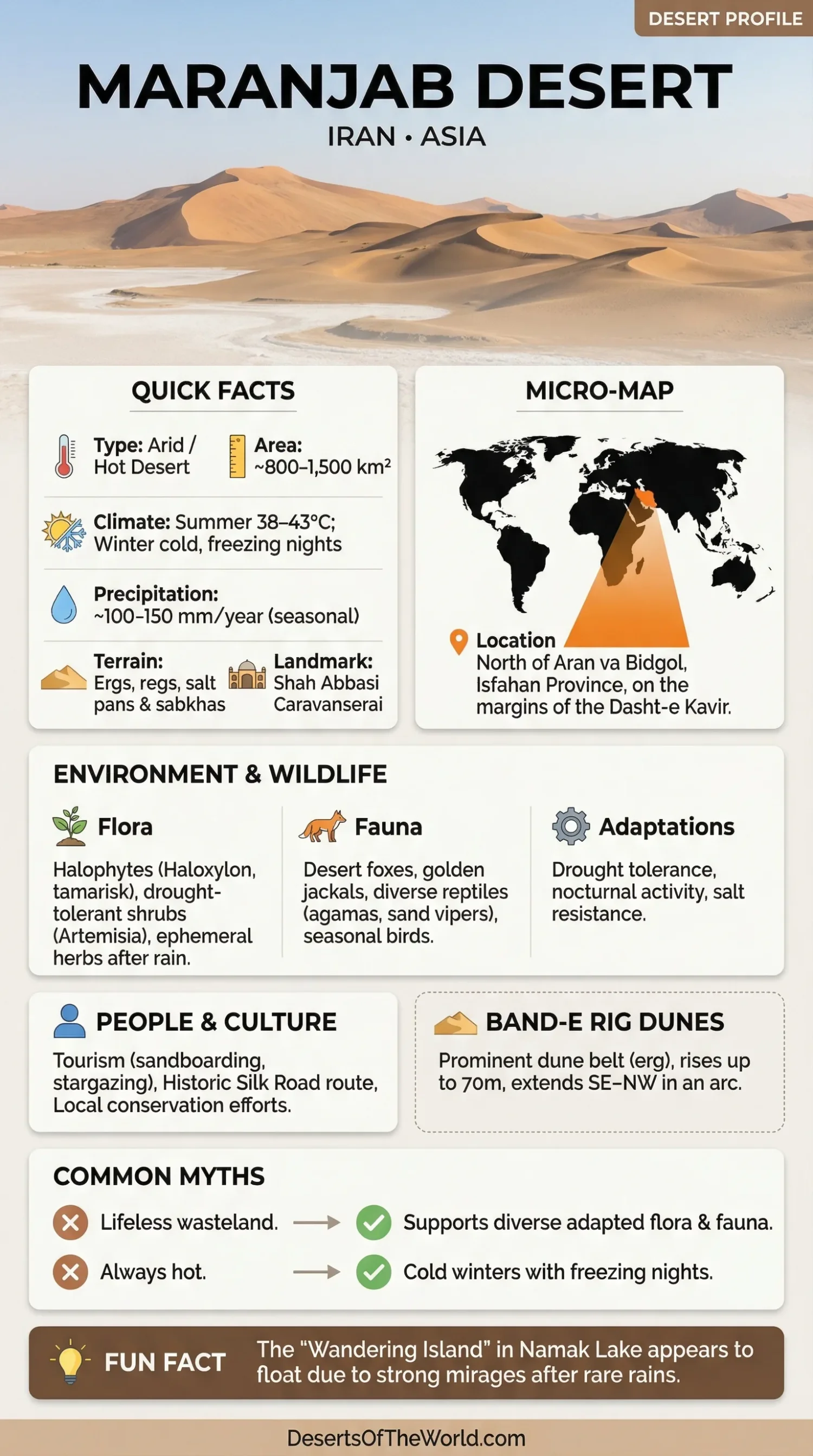
Location & Continent
Continent: Asia
Country: Iran (Isfahan Province – Aran va Bidgol County, near Kashan)
Coordinates: 34.3003°N, 51.8324°E
The Maranjab Desert lies in central Iran, north of Aran va Bidgol and near Kashan. It occupies part of the dry landscape along the western side of the broader Dasht-e Kavir basin, where dune fields, salt-rich lowlands, gravel plains, and sparse desert vegetation occur close together.
Maranjab is closely associated with Namak Lake to the north and the Band-e Rig dune belt. The transition between sand and saline terrain is one of the defining physical features of this part of Isfahan Province.
Maranjab Desert – Map & Street View
Photos of the Maranjab Desert
Physical Features
| Feature | Measurement or Description |
|---|---|
| Area | ~800–1,500 km² (estimates vary by source) |
| Length | Band-e Rig dune belt ~80–120 km (SE–NW arc) |
| Width | Band-e Rig typically ~18–25 km |
| Elevation | Dune field ~850–1,000 m; nearby Namak (Salt) Lake ~790 m |
| Main Surfaces | Sand dunes, gravel plains, saline flats, salt crusts, and dry basin terrain |
The quoted area of ~800–1,500 km² should be understood as an estimate rather than a sharply surveyed administrative boundary. Maranjab blends into neighboring dune and salt-basin landscapes, so the total depends on which surrounding surfaces are counted as part of the desert.
Band-e Rig Dune Belt
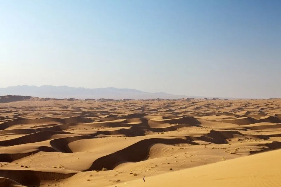
The Band-e Rig dune system forms one of the most recognizable parts of Maranjab. It extends in a broad southeast-to-northwest arc, with published measurements placing the belt at roughly 80–120 km long and commonly around 18–25 km wide.
This is not one continuous dune ridge. The sandy zone contains dunes of different shapes and sizes, broad accumulations of windblown sand, firmer areas between dunes, and transitions toward gravelly or saline ground. Wind repeatedly moves loose surface material, so small dune forms can change even when the larger dune belt remains in roughly the same position.
Elevation and Basin Relief
Much of the Maranjab dune field lies around 850–1,000 m above sea level. Nearby Namak Lake occupies lower ground at about 790 m. This difference helps define the local relief: sandy terrain sits above the lowest salt-basin surfaces, where water and dissolved minerals tend to collect.
The elevation change is modest compared with mountain deserts, but over a broad, open basin it strongly influences drainage, salt accumulation, and the distribution of sandy versus saline landforms.
Climate & Precipitation
Temperature: Hot, arid summers, with daytime temperatures often around 38–43 °C; winters are dry, with nights that can approach or fall below 0 °C.
Precipitation: Low and highly seasonal, roughly 100–150 mm/year in the wider Kavir–Namak Lake region. Most rainfall occurs from November to April, while summers are frequently rainless.
The climate reflects Maranjab’s location in the dry interior of Iran. Clear skies, low humidity, sparse vegetation, and exposed ground allow the surface to heat rapidly during the day. After sunset, that heat can escape quickly, especially during winter.
Seasonal Rainfall Pattern
Rain does not fall evenly through the year. The cooler months provide most of the limited precipitation, while summer can remain dry for long periods. Individual storms can still produce short-lived pools, damp salt flats, or temporary runoff even though annual rainfall totals stay low.
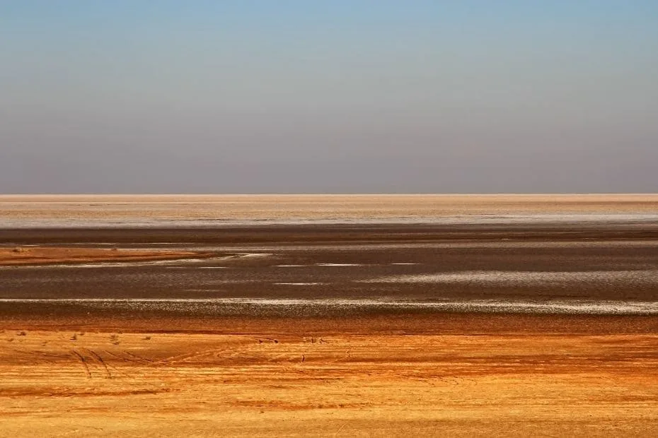
On the margins of Namak Lake, these wet periods can briefly change the appearance of the landscape. Once water evaporates, dissolved salts remain at the surface and can form pale crusts or polygon-like salt patterns.
Day and Night Temperature Changes
A large difference between daytime and nighttime temperature is common in dry environments. Maranjab’s bare ground absorbs solar energy efficiently during daylight, yet dry air retains less heat after sunset than humid air. The result can be a warm or hot afternoon followed by a much cooler night.
This seasonal and daily variation means that the desert should not be thought of as permanently hot. Winter nights can be cold.
Ecological Features
Ecozone: Palearctic
Biome: Deserts & Xeric Shrublands
Ecoregion: Central Persian Desert Basins (WWF PA1313)
Maranjab belongs to the dry ecological systems of Iran’s interior basins. The landscape may appear sparsely vegetated, yet plant communities differ noticeably between sandy dunes, firmer desert soils, and saline flats.
Water availability and soil salinity are especially important. Plants growing close to salt-rich ground face a different set of conditions from shrubs rooted in deeper dune sand. This produces a patchy ecological pattern rather than an even cover of vegetation.
Flora & Fauna
Flora: Halophytes and drought-tolerant shrubs including Haloxylon (saxaul), tamarisk, Calligonum, Zygophyllum, and sagebrush (Artemisia) occur on sands and saline flats. Scattered acacia and hardy ephemeral herbs may appear after rainfall.
Fauna: Desert foxes, golden jackals, wolves, striped hyenas, and hares occur in the wider desert region, along with reptiles such as agamas, geckos, and sand vipers. Raptors and wintering waterbirds can also be found around Namak Lake in wetter years.
Plants Adapted to Sand and Salt
Salt tolerance and drought resistance are two recurring traits among Maranjab’s plant life. Species of Haloxylon and tamarisk can survive where rainfall is scarce and soils contain elevated mineral concentrations. Shrubs rooted in sand also help trap windblown sediment around their stems.
Ephemeral plants follow another strategy. Instead of remaining visibly active throughout the year, some grow rapidly after suitable rainfall, flower, and complete much of their life cycle before the surface dries again.
Animals of the Wider Desert Region
Mammals in the wider landscape tend to use large territories because food, shade, and water are widely scattered. Foxes, jackals, hares, wolves, and striped hyenas are among the animals associated with this central Iranian desert environment.
Reptiles are well suited to the warm ground and sparse vegetation. Agamas, geckos, and snakes use dunes, rocky surfaces, and shrub cover for shelter. Many species avoid the hottest hours by remaining beneath vegetation, inside burrows, or in shaded cracks.
Namak Lake creates a different habitat when water is present. In wetter periods, shallow water and moist flats can attract seasonal and wintering birds, adding temporary aquatic habitat beside the dry dune system.
Geology & Notable Features
Geology: Maranjab lies on the margins of the Dasht-e Kavir basin and includes ergs, gravelly flats, salt pans, and polygon-crusted saline surfaces. The Band-e Rig dune complex forms a broad crescent-shaped belt, with dunes and sandy hills rising above the surrounding flats.
Notable Features: Shah Abbasi (Maranjab) Caravanserai on the historic Silk Road; the Band-e Rig dune system; Namak (Salt) Lake and the “Wandering Island” (Jazire-ye Sargardān); traditional qanat features; and a freshwater spring near the caravanserai.
Ergs, Gravel Plains and Salt Pans
Maranjab is often pictured as a field of dunes, but sand represents only part of the local desert system. An erg is a sandy desert surface dominated by dunes, while a reg consists mainly of gravel and coarser material. Both occur in the wider region.
Lower parts of the basin form salt pans and saline flats. Water flowing into these depressions carries dissolved minerals. Because the basin is extremely dry and evaporation is strong, much of the water disappears while salts remain behind.
Namak Lake
Namak Lake lies near the northern side of Maranjab at an elevation of about 790 m. For much of the year, large parts of the lake basin are dry or covered by salt-rich surface material rather than permanent open water.
After rainfall, shallow water may temporarily cover sections of the basin. Evaporation then exposes salt again. Repeated wetting and drying can create geometric patterns in the crust, giving the lake bed a very different appearance from the neighboring dunes.
Wandering Island
The feature known as Jazire-ye Sargardān, or the “Wandering Island,” lies within the Namak Lake landscape. It does not physically drift across the basin. Its name comes from the way the low outcrop can appear to change position when shallow water, reflections, heat shimmer, and mirage effects alter the viewer’s sense of distance.
Flat desert horizons provide few nearby reference points, so these optical effects can be especially noticeable.
Maranjab Caravanserai and Historic Routes
The Shah Abbasi Maranjab Caravanserai is one of the best-known built landmarks in the desert. Its position beside a historic route reflects the practical demands of movement through central Iran’s dry interior, where dependable stopping places were closely tied to water and accessible terrain.
The caravanserai sits between sandy terrain and the salt-basin landscape. Travelers moving across the region could use such roadside inns for shelter and rest before continuing across long stretches of sparsely settled country.
The structure is associated with the Safavid period and the historic Silk Road network. Its presence also explains why Maranjab is known for more than dunes alone: natural landforms and long-established travel routes occupy the same desert setting.
Fresh Water Near Saline Ground
Freshwater sources near the caravanserai stand in marked contrast to the salt-rich surfaces around Namak Lake. This is possible because groundwater can move through layers of sand and sediment differently from surface water in a salt basin.
Local variations in sediment, drainage, and underground flow can therefore place usable fresh water relatively close to highly saline ground. In an arid landscape, that difference has long influenced where routes and stopping places could develop.
Main Landscape Zones
| Zone | Main Characteristics |
|---|---|
| Band-e Rig | Large dune belt with mobile and semi-mobile sand forms. |
| Desert Plain | Dry open ground containing gravel, sand, and sparse shrubs. |
| Saline Flats | Salt-rich lowlands with limited vegetation and periodic surface moisture. |
| Namak Lake Basin | Low-lying salt-lake environment that may hold shallow water after rainfall. |
| Vegetated Margins | Scattered drought-tolerant and salt-tolerant shrubs where soil conditions permit. |
These zones occur close enough to one another that a relatively short distance can produce a clear change in surface texture and color. Golden sand, dark gravel, pale salt crust, and sparse green shrubs can all form part of the same regional desert system.
Seasonal Conditions
| Season | Typical Conditions |
|---|---|
| Winter | Cooler days and cold nights; temperatures can approach or fall below 0 °C overnight. |
| Spring | Temperatures rise, while occasional rain can temporarily alter salt-flat and vegetation conditions. |
| Summer | Hot and usually very dry; daytime temperatures often reach about 38–43 °C. |
| Autumn | Daytime heat gradually decreases and cooler nighttime conditions return. |
The period from roughly October through April generally has milder daytime conditions than summer. Clear skies can still produce sharp temperature changes between afternoon and night, particularly during the colder months.
References
FAQ
Where Exactly Is the Maranjab Desert?
It lies north of Aran va Bidgol in Isfahan Province, near Kashan and on the margins of the Dasht-e Kavir. The desert also lies close to Namak Lake.
How Large Is the Maranjab Desert?
The desert is estimated at roughly 800–1,500 km², although estimates vary because Maranjab does not have one universally defined natural boundary. The surrounding dunes, salt flats, and dry basin terrain merge gradually into neighboring desert areas.
How Large Is the Band-e Rig Dune Belt?
The Band-e Rig dune belt is approximately 80–120 km long along its southeast-to-northwest arc and is typically around 18–25 km wide.
What Is the Elevation of Maranjab?
The main dune field lies at roughly 850–1,000 m above sea level. Nearby Namak Lake occupies lower ground at approximately 790 m.
How Much Rain Does Maranjab Receive?
Annual precipitation in the wider Kavir–Namak Lake region is roughly 100–150 mm. Most precipitation falls between November and April, while summer is frequently rainless.
How Hot Does the Maranjab Desert Get?
Summer daytime temperatures often reach around 38–43 °C. Winter is much cooler, and nighttime temperatures can approach or drop below 0 °C.
Is Maranjab a Sand Desert or a Salt Desert?
It contains both sandy and saline landscapes. Band-e Rig forms the main dune system, while Namak Lake and nearby lowlands contain salt pans, saline flats, and salt-crusted surfaces.
Is There Wildlife in Maranjab?
Yes. The wider region supports foxes, golden jackals, wolves, striped hyenas, hares, reptiles, raptors, and seasonal birds. Wildlife varies between sandy terrain, shrub-covered areas, and the Namak Lake basin.
What Plants Grow in the Maranjab Desert?
Drought- and salt-tolerant plants include Haloxylon, tamarisk, Calligonum, Zygophyllum, and Artemisia. Plant cover is sparse and changes according to soil moisture and salinity.
Why Is the “Wandering Island” Famous?
After rainfall, shallow water can surround the low outcrop in Namak Lake. Reflections, heat shimmer, and mirage effects may then make the feature appear to shift or float against the flat horizon.
When Are Conditions Mildest in Maranjab?
The period from October through April generally brings milder daytime temperatures than summer. Winter nights can still become cold, so daytime and nighttime conditions may differ sharply.