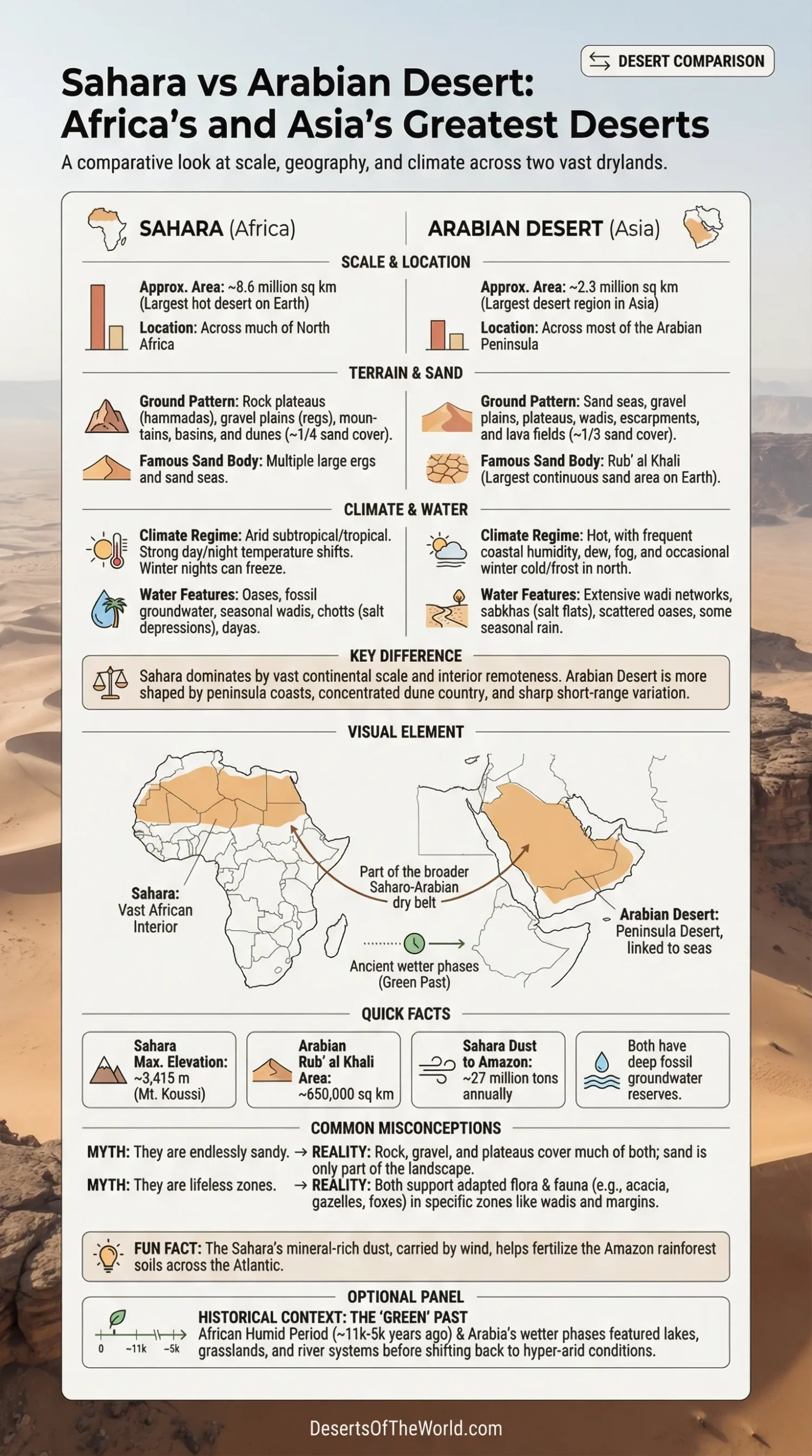
The Sahara and the Arabian Desert define hot-desert geography in Africa and Asia, yet they do not behave like twins. The Sahara is the larger continental mass, spread across North Africa from the Atlantic side to the Red Sea. The Arabian Desert is smaller, but tighter in form and more strongly shaped by peninsula coasts, escarpments, giant sand seas, and dry river channels. Put them side by side and the contrast is plain: one dominates by scale, the other by concentrated dune country and sharp regional variety.
| Measure | Sahara | Arabian Desert |
|---|---|---|
| Approximate Area | About 8.6 million sq km | About 2.3 million sq km |
| General Position | Across much of North Africa | Across most of the Arabian Peninsula |
| Overall Standing | Largest hot desert on Earth | Largest desert region in Asia |
| Most Famous Sand Body | Multiple ergs and sand seas | Rub’ al Khali, the largest continuous sand area on Earth |
| Typical Ground Pattern | Rock plateaus, gravel plains, mountains, basins, and dunes | Sand seas, gravel plains, plateaus, wadis, escarpments, and lava fields |
| Water Pattern | Oases, fossil groundwater, seasonal wadis, chotts, and dayas | Wadi networks, sabkhas, scattered oases, dew, fog, and short seasonal rains in some sectors |
Where These Two Deserts Sit
The Sahara fills nearly the whole northern belt of Africa. Its west-to-east reach is about 4,800 km, and its north-to-south breadth varies widely. That scale matters. The desert acts less like a single dune field and more like a dry continent inside a continent.
The Arabian Desert covers almost the full interior of the Arabian Peninsula. Saudi Arabia holds the largest share, with extensions into Jordan, Iraq, Kuwait, Qatar, the United Arab Emirates, Oman, and Yemen. Seas and gulfs sit around much of its margin, so the Arabian Desert interacts more directly with coastal humidity, escarpments, and mountain rims than the Sahara does.
Location shapes everything. The Sahara reads as a vast African interior. The Arabian Desert reads as a peninsula desert, linked to the Red Sea, the Gulf, the Arabian Sea, and the uplands that ring parts of the peninsula.
Scale and Shape
By broad modern estimates, the Sahara is about 3.7 times larger than the Arabian Desert. That difference is not cosmetic. It changes travel distance, climate rhythm, biological distribution, and even the way people imagine each desert.
The Sahara has room for separate mountain massifs, giant gravel plains, salt basins, dune seas, and far-flung oasis systems, all within one desert name. The Arabian Desert is smaller, but it is not simple. Inside it sit several large desert units that many readers know as landscapes in their own right: Rub’ al Khali, An Nafud, Ad Dahna, basaltic harrat, interior plateaus, and low salt flats.
Huge, yes. Uniform, no.
Ground Underfoot
Sand, Rock, and Mountains in the Sahara
Many people picture the Sahara as endless dunes. That picture is only partly right. Sand sheets and dunes cover roughly one-quarter of the Sahara’s surface. The rest includes regs (gravel plains), hammadas (rocky plateaus), shallow basins, seasonal salt depressions, and mountain blocks such as the Tibesti and Ahaggar. The Sahara’s highest point, Mount Koussi in Chad, rises to 3,415 metres.
This is why the Sahara feels so broad in character. A person can move from a dune sea to a black rock plateau, then to a dry basin, then to a mountain zone that holds a little more life than the open plain around it. In physical geography terms, it is not one desert scene repeated over and over.
Sand Seas, Plateaus, and Lava Fields in Arabia
The Arabian Desert has a stronger sand identity, though even here the story is wider than dunes alone. At least one-third of the desert is covered by sand. The star landform is Rub’ al Khali, which covers about 650,000 sq km and forms the largest continuous sand area on Earth. In the north lies An Nafud, about 65,000 sq km. Between them runs Ad Dahna, a long red-sand corridor around 1,200 km in length.
Yet Arabia is not only sand. Broad plateaus, gravelly surfaces, escarpments, and black basalt lava fields are part of the same desert system. From above, the contrast can be striking: pale dunes, dark volcanic tracts, broken mountain lines, and dry drainage paths all packed into one peninsula.
If the Sahara is the more varied desert at continental scale, the Arabian Desert is the more concentrated lesson in how many dryland surfaces can sit close together.
Climate and Moisture
Heat, Cold, and Daily Range
Both deserts are hot-desert systems, though their heat is not identical in feel or pattern. The Sahara is controlled by a dry subtropical regime in the north and a dry tropical regime in the south. Clear skies, very low humidity, and sparse vegetation allow strong heating by day and sharp cooling after sunset. Winter nights in northern sectors can drop below freezing.
The Arabian Desert is also fiercely hot, with summer temperatures reaching about 55°C in places. Still, Arabia adds another layer: more frequent coastal humidity, night dew in some sectors, fog along some margins, and occasional winter cold in the north. The contrast can surprise people. In the far north of Arabia, frost or even snowfall can occur during unusual cold spells.
Dry they both are, yet their moisture behavior is not the same.
Why the Arabian Desert Often Feels More Mixed
The Sahara has very large hyper-arid tracts and a stronger sense of interior remoteness. The Arabian Desert, by contrast, sits closer to several bodies of water and to mountain chains that help create local variation. Some southern and coastal sectors receive moisture from seasonal air flows tied to the Indian Ocean, while parts of the interior stay among the driest zones in Southwest Asia.
That makes the Arabian Desert more patchy in climate at short range. A humid coastal edge, a steep escarpment, a gravel plain, and an empty dune basin can stand surprisingly close to one another.
Water, Oases, and Salt Flats
How Water Appears in the Sahara
Surface water is scarce, though the Sahara is not truly waterless. It contains large oasis depressions, many wadis, chotts, and dayas. Some wadis still carry seasonal flow after rain, while others are old channels shaped during wetter phases in the past. Beneath parts of the Sahara lie major stores of old groundwater, often called fossil water, held in large aquifer systems.
That hidden water has long mattered for settlement. Oasis agriculture, date palms, wells, and small garden belts depend on it. In many Saharan districts, life gathers not around rivers but around points where groundwater can be reached.
How Water Moves Through Arabia
The Arabian Desert has no broad network of permanent interior rivers, yet running water has done a great deal of shaping there. About two-thirds of the desert is drained by complete wadi systems. These channels may stay dry for long periods, then carry sudden runoff after rain. In many parts of Arabia, intermittent water flow has carved the ground more effectively than wind has.
Salt flats matter in both deserts, but Arabia has a strong sabkha story. A sabkha is a saline flat or salt-crusted depression, common along the southern Persian Gulf coast and in low basins where evaporation concentrates salts. The Sahara has its own salt depressions too, especially chotts in the north. So the visual rhythm differs a little: in the Sahara, broad interior basins and oasis pockets stand out; in Arabia, wadis and sabkhas are more central to the landscape pattern.
Plants and Animals
Neither desert is empty of life. Sparse, yes. Empty, no.
In the Sahara, vegetation tends to gather in highlands, wadis, oasis depressions, and better-watered edges. Salt-tolerant plants grow in saline flats, while grasses, shrubs, and scattered trees appear where soil moisture lingers a little longer. After rain, short-lived annuals can complete their life cycle with great speed. Animal life includes fennec foxes, dorcas gazelles, addax in suitable areas, dromedaries, reptiles, and many smaller desert specialists.
The Arabian Desert supports similarly adapted life, though often with a different distribution pattern. Shrubs may be widely spaced across sandy or gravelly ground, acacias appear mainly toward margins and drainage zones, and the heart of Rub’ al Khali is botanically very thin. Britannica notes that only about 37 plant species have been identified there. Fauna linked with Arabian drylands include Arabian oryx, sand gazelles, foxes, rodents, reptiles, and birds fitted to open desert, escarpments, or desert-edge habitats.
One useful way to compare them is this: the Sahara offers broader ecological zoning across a bigger map, while Arabia packs sharp transitions into shorter distances.
How People Have Lived with These Deserts
The Sahara and the Arabian Desert both supported mobile pastoral life, oasis farming, and trade, though the settings differed. In the Sahara, caravan movement tied oasis towns and Sahelian margins to Mediterranean North Africa. Salt, dates, textiles, and many other goods moved through chains of stopping points where water could be found. Settlement stayed scattered and strongly tied to oases, highlands, and outer margins.
In the Arabian Desert, Bedouin life grew around camels, sheep, horses, wells, pasture timing, and knowledge of routes between the interior and the coasts. Oases also mattered here, but the peninsula setting gave Arabia a denser relationship with seaports, escarpment towns, and highland agriculture on its edges.
In both deserts, the lesson is much the same: where water appears, even briefly, people build systems around it. Very practical systems.
Why the Sahara and Arabian Desert Are Often Linked
Geographers and paleoclimate researchers often connect these two deserts because they sit within the same broad Saharo-Arabian dry belt. Today that belt forms a major arid barrier between wetter parts of Africa and Eurasia. Yet it was not always this dry.
The Sahara went through a much wetter phase during the African Humid Period, roughly 11,000 to 5,000 years ago, when lakes, wetlands, grasslands, and river systems extended across areas that are now barren. Arabia also had wetter windows. Recent cave and lake records from the peninsula show repeated humid phases in the deeper past, with grasslands and surface water appearing far beyond their modern limits.
This older wet history helps explain why the Sahara and Arabian drylands share so many biological and geographic links. They are separate deserts, yes, but they also belong to one larger story of shifting rain belts, monsoon reach, ancient lakes, and retreating vegetation.
How Far Their Influence Reaches
The Sahara has the larger global atmospheric footprint. NASA satellite work has shown that winds lift about 182 million tons of Saharan dust past the desert’s western edge in an average year, and roughly 27 million tons of that dust reaches the Amazon Basin. So the Sahara does not end at its own margins; its dust affects skies, soils, and seas far away.
The Arabian Desert has a more regional climate role. Its dust, dry air, wadis, salt flats, and coastal humidity gradients shape environmental conditions around the Red Sea, the Gulf, and the Arabian Sea margins. Less global in image, perhaps, but very strong in regional effect.
Which Desert Feels Larger, Sandier, or More Severe?
Larger: the Sahara, by a wide margin.
Sandier In the Popular Imagination: often the Arabian Desert, because Rub’ al Khali, An Nafud, and Ad Dahna create giant connected dune landscapes. The Sahara has famous dunes too, but much of it is rock, gravel, plateau, and basin.
More Varied In Landform: the Sahara. Its scale allows a wider spread of mountain massifs, ergs, hammadas, regs, chotts, and oasis systems.
More Mixed In Short-Range Climate: the Arabian Desert, because coastal humidity, fog, escarpments, and interior dryness can sit close together.
More Severe: that depends on what is being measured. For pure continental immensity and vast interior dryness, the Sahara stands apart. For giant uninterrupted sand, difficult dune basins, and very hot, humid margins near some coasts, the Arabian Desert can feel just as exacting in a different way.
Sources
- Encyclopaedia Britannica: Sahara (area, landforms, climate, drainage, and general physical geography)
- Encyclopaedia Britannica: Arabian Desert (area, geology, climate, wadis, people, and regional setting)
- Encyclopaedia Britannica: Rub’ al Khali (largest continuous sand area, relief, and location)
- NASA Earth Observatory: A Deluge For The Sahara (rare rainfall in the Sahara and hyper-arid context)
- NASA Goddard: Saharan Dust Feeds Amazon Plants (dust transport and the Sahara’s far-reaching atmospheric role)
- NOAA Paleoclimatology: End Of The African Humid Period (wetter Sahara in the Holocene and later drying)
- Northumbria University: Arabia’s Green Past (humid phases in Arabia and the idea of “Green Arabia”)