
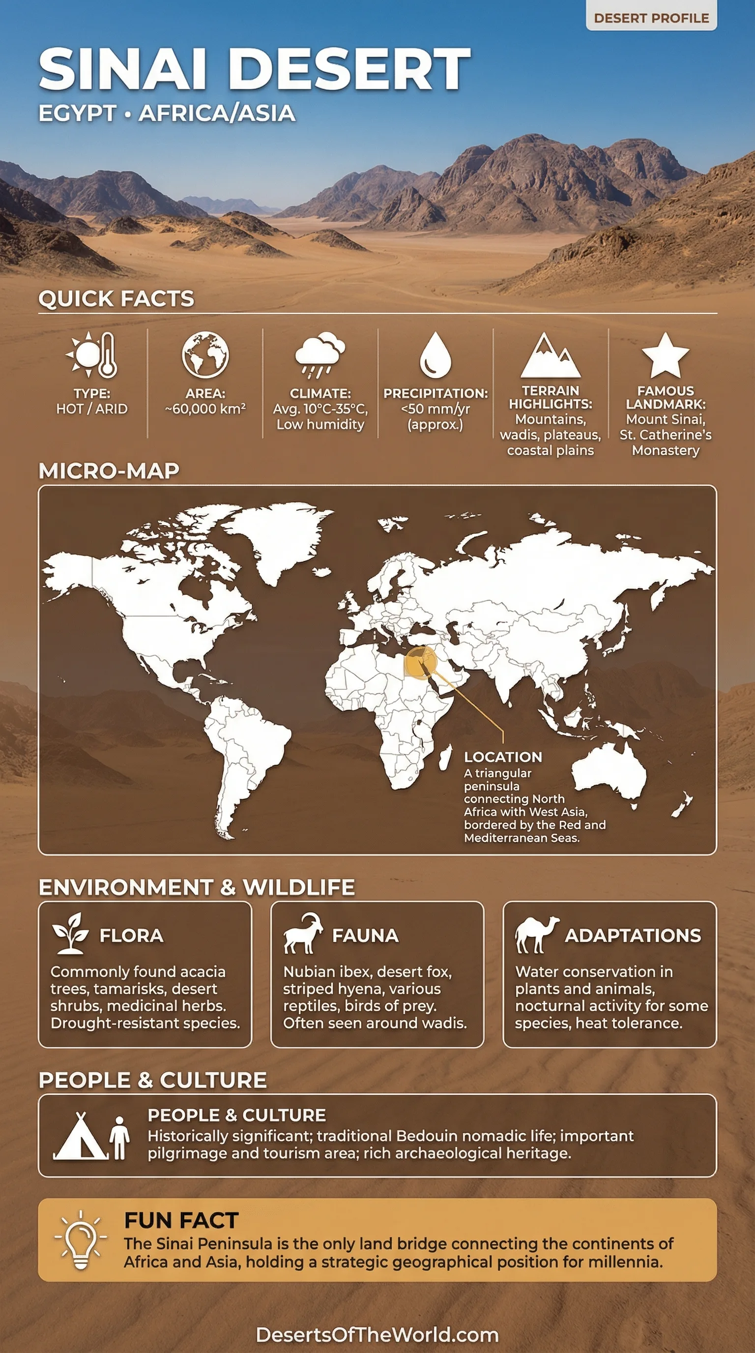
Location and Regional Context
Continent: Asia (Western Asia)
Country: Egypt
Region: Sinai Peninsula
Central Coordinates: 29.50°N, 33.83°E
The Sinai Desert lies on the Sinai Peninsula, a rugged, triangular land bridge between Africa and Asia. With the Mediterranean to the north and the Red Sea to the south, Sinai contains coastal plains, plateaus, wadis, and mountain terrain within a relatively compact area.
Sinai Desert – Map Views
Physical Features
Land Area (Sinai Peninsula): About 60,000–61,000 km²
Approximate Dimensions: ~380 km north–south; ~210 km west–east
Elevation Range: Sea level to about 2,642 m (Mount Catherine)
The Sinai Desert is not dominated by sand alone. Rock deserts cover much of the interior, while sand sheets and dunes are more common in the north and in some low basins.
Climate and Seasonal Weather
Climate Type: Predominantly arid desert; local cold-desert traits at high elevations
Rain Pattern: Sparse overall; most rain arrives in cooler months as short-lived storms
Typical Conditions: Hot sun, low humidity inland; cooler and windier near coasts and peaks
Summers are hot and dry across much of Sinai, while high ground can become markedly cooler in winter. Low rainfall and sharp day–night temperature contrasts influence plant activity, evaporation, and the behavior of wadis after rare storms.
Ecological Setting
Realm: Palearctic
Biome: Deserts and xeric shrublands
Common Habitats: Rocky slopes, limestone plateaus, sandstone plains, gravel fans, coastal desert
Ecological conditions vary sharply across short distances. Plants and animals are often concentrated where shade, stone, and moisture occur together, especially in microhabitats such as rock cracks, wadi beds, and pockets of deeper soil.
Flora and Fauna
Plants Often Associated With Sinai’s Desert Landscapes
- Acacia (notably umbrella-shaped desert forms) in wadis and runoff zones, where trees provide shade and help support local wildlife.
- Tamarisk and salt-tolerant shrubs in drier flats and some coastal pockets exposed to saline soils and coastal winds.
- Ephemeral wildflowers that appear briefly after sufficient rainfall.
- Hardy grasses and low shrubs adapted to dry plateau conditions.
Wildlife Commonly Found Across Sinai Desert Habitats
- Mountain and cliff specialists in the southern highlands, using ledges and gullies as natural movement routes, with granite walls providing cover.
- Small mammals and nocturnal foragers that avoid midday heat by shifting activity into the cooler hours.
- Reptiles adapted to dry ground and short periods of activity, often using coloration that blends with sand and gravel.
- Migratory birds passing through seasonally, because Sinai’s geography funnels movement between larger landmasses.
Timing is an important part of survival in Sinai. Many animals reduce activity during the hottest part of the day and become active when temperatures fall, while many plants respond rapidly when enough rain reaches the soil.
Geology and Landforms
Sinai’s desert landforms reflect the distribution of rock types across the peninsula. The region consists of three main geological zones: crystalline mountains in the south, broad limestone plateaus in the center, and sandstone plains in parts of the north. Differences in rock structure and erosion produce marked variations in elevation, surface texture, and landform patterns over short distances.
| Zone | Typical Terrain | What It Looks Like | Why It Matters |
|---|---|---|---|
| Southern Highlands | Granite and metamorphic massifs | Jagged peaks, narrow valleys, rocky slopes | Creates cooler microclimates and pockets where plants can persist |
| Central Plateau | Limestone tablelands and gravel plains | Wide horizons, pale rock surfaces, wind-shaped textures | Channels runoff into wadis; forms broad catchments |
| Northern Lowlands | Sandstone, sand sheets, and coastal plains | Sandy expanses, gentle ridges, dune patches | Closer to Mediterranean influences; more frequent plant flushes after rain |
Wind continually moves loose sediment, while episodic rainfall can erode slopes, shift gravel, and refill shallow channels. Storm runoff can leave fresh alluvial fans, exposed rock surfaces, and reorganized wadi beds.
Understanding the “Desert” in Sinai Desert
The phrase Sinai Desert usually describes the peninsula’s broad arid interior rather than a single, clearly defined desert unit. Sinai includes several desert types: rock deserts dominated by exposed stone, sand landscapes shaped by wind deposition, and wadi networks that channel seasonal water flow.
On a map, Sinai may appear as a simple landmass between two seas, but its terrain varies widely. Cliffs, plateaus, gravel plains, dunes, and wadis reflect different rock types and repeated erosion by wind and episodic runoff.
Wadis, Water, and Desert Hydrology
In Sinai, there are no permanent rivers. Water is mainly stored in groundwater and small springs, and it flows through dry channels after rainfall. A wadi is usually dry but can carry water and sediment for a short period following a storm, reshaping the surface of the land.
Wadi floors often contain deeper soils, scattered vegetation, and occasional trees. These areas form narrow green corridors across the surrounding desert. In Sinai’s desert ecology, wadis support many plant and animal communities.
Coasts, Gulfs, and Edge Effects
Sinai’s desert is bordered by water on multiple sides, and those edges affect local conditions. The Gulf of Suez and the Gulf of Aqaba frame the peninsula’s southern reaches, while the Red Sea and Mediterranean influence wind patterns and humidity gradients. Even small differences in moisture can affect where shrubs and other vegetation persist.
Coastal desert zones differ from the interior through stronger maritime influence, greater exposure to wind, and more saline conditions in some locations. These edge effects contribute to ecological variation across the peninsula.
Human Activity and Land Use
People have interacted with Sinai’s desert for a very long time, often following the availability of water and shade. Traditional knowledge includes routes, seasonal grazing, and ways of using scarce resources under highly variable rainfall conditions.
Sinai is also linked to ancient stonework and early mineral use, including areas known for turquoise in the broader peninsula. The dry climate and sparse vegetation can leave old pathways, walls, and working sites visible for long periods.
Protected Areas and Biodiversity
Several protected areas in Sinai conserve desert, mountain, and coastal habitats. The Saint Katherine region is known for rugged highlands and distinctive habitats, while coastal protected areas contain adjoining marine and desert ecosystems.
Recovery from disturbance can be slow in arid environments. Damaged shrubland may take many seasons to recover, and disturbed soil crusts can alter infiltration, erosion, and seed establishment for years.
Research and Monitoring in the Sinai Desert
Researchers use Sinai to study arid landscapes through satellite imagery, field surveys, and geological mapping. Satellite data can track shifting sand, seasonal vegetation changes, and the effects of storms, while field geology records rock textures, fault lines, and the way valleys cut through plateaus.
Remote sensing shows broad surface patterns, while fieldwork records finer details such as gravel size, soil crusts, plant roots, and small areas where vegetation persists.
References
UNESCO World Heritage Centre – Saint Catherine Area (Sinai)
NASA Earth Observatory – Dry Country of Turquoise (Sinai)
NASA Earth Observatory – Fisheye Over Sinai
Egyptian Environmental Affairs Agency (EEAA) – Welcome to St. Katherine (PDF)
Egyptian Environmental Affairs Agency (EEAA) – Ras Mohammed National Park Document (PDF)
Copernicus Publications – Sinai Peninsula Rainfall and Extremes (Open Access Paper)
Springer (PDF) – Overview of Sinai Geology and Rock Provinces