
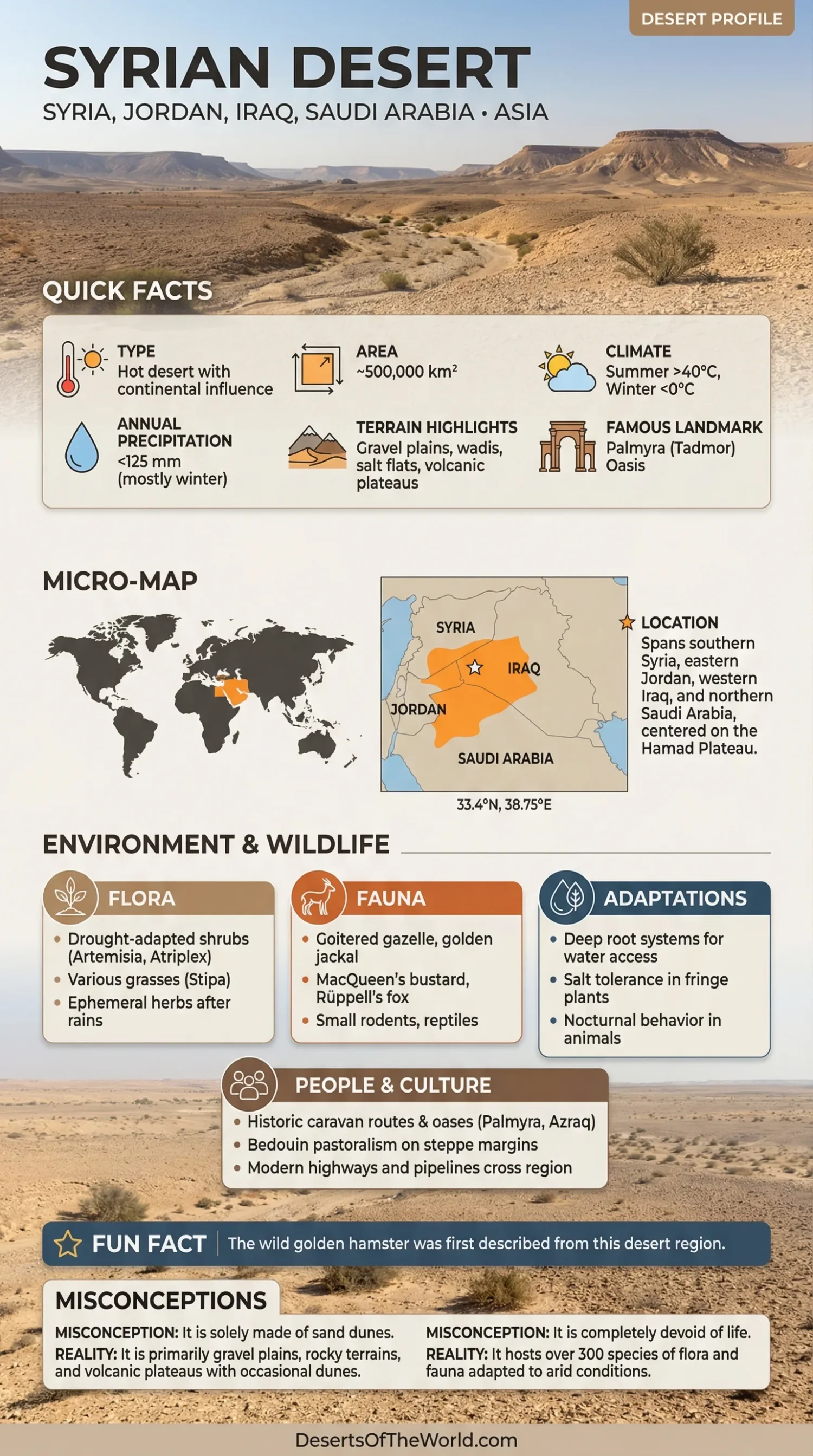
Location & Continent
Continent: Asia
Countries: Syria, Jordan, Iraq, Saudi Arabia
Regional Name: Bādiyat ash-Shām, commonly translated as the Syrian Desert or Syrian Steppe
Coordinates: ~33.4°N, 38.75°E
Physical Features
Area: Approximately 500,000 km² under the broad regional definition
Terrain: Stony plains, gravel desert, limestone plateaus, dry valleys, salt depressions, isolated sandy areas, and basalt lava fields
Elevation: Much of the interior plateau lies several hundred meters above sea level; uplands rise substantially higher
Major Landform: Harrat ash-Shām, a basaltic volcanic province extending through southern Syria, eastern Jordan, and northern Saudi Arabia
Climate & Precipitation
Climate: Arid to semi-arid continental conditions
Temperature: Summer daytime temperatures commonly exceed 40°C in low desert areas; winter nights can fall to freezing or below on exposed plateaus
Precipitation: Low and highly variable; the Syrian Badia generally receives less than 200 mm annually, with Palmyra averaging about 127 mm in a long-term FAO dataset
Rainfall Season: Most precipitation falls during the cooler months, while summers are usually dry
Ecological Features
Biogeographic Realm: Palearctic
Environment: Desert, semi-desert, and dry steppe
Syrian Badia: Covers about 55% of Syria and consists largely of dry rangeland receiving less than 200 mm of annual rainfall
Main Habitats: Dwarf-shrub plains, rocky uplands, seasonal wetlands, oases, wadis, and volcanic terrain
Flora & Fauna
Flora: Dwarf shrubs, perennial grasses, annual plants after winter rain, Artemisia, Atriplex, Haloxylon, and salt-tolerant plants around saline depressions
Fauna: Gazelles, foxes, rodents, reptiles, steppe birds, and other animals adapted to dry rangelands; several larger desert species have declined greatly or disappeared from parts of their former range
Geology & Notable Features
Geology: Limestone and sedimentary plateaus dominate large areas, while the southwest contains extensive basalt associated with the Harrat ash-Shām volcanic province
Notable Features: Harrat ash-Shām, Jabal al-Druze, Palmyra oasis, Hamad Plateau, seasonal salt depressions, gravel plains, and dry wadi systems
Human Geography
Pastoralism: Seasonal livestock grazing has long been part of land use across the Badia
Historic Routes: Oasis settlements such as Palmyra connected routes between the Levant and Mesopotamia
Modern Infrastructure: Roads, pipelines, settlements, and grazing areas cross large parts of the desert and steppe
Syrian Desert
The Syrian Desert, or Bādiyat ash-Shām, is a broad dryland region extending across parts of Syria, Jordan, Iraq, and northern Saudi Arabia. It covers roughly 500,000 km² and includes true desert, semi-desert, and steppe rather than one continuous expanse of sand.
Most of the terrain consists of open gravel or stony plains crossed by dry valleys. The southwestern part is very different: dark basalt flows, volcanic cones, and lava-covered ground form the Harrat ash-Shām. Rainfall also changes across the region, allowing seasonal grass and shrub growth in areas commonly described as the Badia.
Geography
The Syrian Desert occupies much of the interior between the more humid Levantine zone to the west and the Euphrates region to the east. Southward, its dry landscapes merge gradually with the deserts of the Arabian Peninsula.
The term Syrian Desert refers to a geographic region larger than the desert areas located inside modern Syria. In Syria itself, the name Al Badia is commonly applied to the dry steppe and rangelands occupying much of the country’s interior.
The landscape includes:
- Gravel Plains: Broad surfaces covered by stone fragments and desert pavement.
- Wadis: Normally dry drainage channels that may carry water after winter storms.
- Plateaus: Open limestone and sedimentary uplands across much of the interior.
- Seasonal Depressions: Low areas where runoff can collect temporarily before evaporating.
- Basalt Fields: Dark volcanic surfaces concentrated mainly toward southern Syria and eastern Jordan.
Large dune fields are less characteristic here than in deserts such as the Rub’ al Khali. Rock, gravel, steppe, and volcanic terrain occupy much of the region.
Harrat ash-Shām and the Black Desert
One of the most distinctive landscapes in the Syrian Desert is Harrat ash-Shām, a volcanic province extending from southern Syria through Jordan into northern Saudi Arabia.
The Smithsonian Global Volcanism Program describes the volcanic field as covering roughly 100,000 km². It contains numerous smaller volcanic centers, lava fields, cones, and basalt plains. Volcanic activity began during the Miocene and continued intermittently into the Holocene.
The last known eruption listed by the Smithsonian occurred around 2670 BCE, with an uncertainty of about 200 years.
In southern Syria, the volcanic province includes Jabal al-Druze and the Es Safa field. In Jordan, the basalt-covered landscape is commonly known as the Black Desert. The dark lava contrasts sharply with the pale limestone and gravel surfaces farther east and north.
Climate
Rainfall is low throughout the Syrian Desert but varies substantially with location and elevation. The Syrian Badia receives less than 200 mm annually across most of its area.
FAO monitoring around Palmyra recorded a long-term annual average of approximately 127 mm. Individual years can differ sharply. In the same monitoring program, annual rainfall ranged from 198 mm in one year to only 27 mm in another.
Most rain arrives during the cooler part of the year. Summer is generally hot and dry, with daytime temperatures above 40°C in many low-elevation areas. Winter brings much colder conditions, including frost and occasional snow on higher ground.
This year-to-year rainfall variation strongly affects vegetation. Annual grasses and herbs can expand rapidly following a wet winter and remain scarce after drought.
Vegetation and Seasonal Growth
The Syrian Desert is not uniformly bare. Plant cover depends mainly on rainfall, soil, elevation, grazing pressure, and access to temporary or underground water.
FAO studies of the Syrian Badia identify four broad ecological settings: shrubby plains, rocky uplands and plateaus, seasonal wetlands, and oases.
Perennial shrubs persist through dry periods more reliably than annual plants. Annual grasses and herbs respond quickly to winter rainfall and may provide short-lived grazing after favorable seasons.
Plants recorded from desert-steppe environments include:
- Artemisia shrubs on dry steppe soils
- Atriplex and other salt-tolerant shrubs
- Haloxylon in drier desert environments
- Perennial grasses used by grazing livestock
- Short-lived annual herbs appearing after rainfall
Vegetation becomes concentrated around wadis, depressions, springs, and places where soils retain more moisture.
Wildlife
Dry plains and rocky uplands support mammals, reptiles, birds, and invertebrates adapted to scarce water and large temperature changes.
Gazelles historically occupied extensive areas of the Badia, while foxes, rodents, reptiles, and steppe birds remain characteristic of suitable desert habitats. FAO records from the Syrian steppe also document the former presence of larger herbivores such as oryx and onagers.
Hunting, prolonged drought, habitat change, and pressure on rangelands have reduced some wildlife populations. Distribution also varies widely across the four countries covered by the Syrian Desert, so individual species should not be assumed to occur throughout the entire region.
Seasonal wetlands and oases support different communities from the open desert. Even temporary pools can provide short-lived habitat after rainfall.
Palmyra and the Desert Oasis
Palmyra lies at an oasis northeast of Damascus on the western interior of the Syrian Desert. Springs and groundwater made permanent settlement possible in an otherwise dry landscape.
Its position allowed it to develop as a caravan center connecting routes between the Mediterranean region, Mesopotamia, Persia, and lands farther east. UNESCO describes Palmyra as an oasis city at the crossroads of several civilizations.
The archaeological property has been on the UNESCO World Heritage List since 1980 and on the List of World Heritage in Danger since 2013. The World Heritage Committee retained it on the danger list in 2026 while conservation, documentation, and recovery work continued.
Palmyra also illustrates the importance of localized water in the Syrian Desert. Springs supported settlement and oasis agriculture in a region where surrounding rangelands depend largely on irregular rainfall.
Pastoralism and Rangelands
The Syrian Badia has long been used for seasonal livestock grazing. Sheep, goats, and camels move through rangelands according to rainfall, forage growth, water availability, and access to crop residues outside the desert.
Traditional seasonal movement allowed herds to use vegetation when forage was available and move elsewhere during the driest months. Over time, settlement, changes in land use, larger livestock populations, and greater demand for fuel and water altered this pattern.
FAO studies of the Syrian Badia documented several pressures on rangelands, including:
- heavy grazing in accessible areas;
- removal of shrubs for fuel;
- large fluctuations in forage production between wet and dry years;
- dependence on limited water sources;
- loss of vegetation during prolonged drought.
These effects are not uniform across the entire Syrian Desert. Conditions differ substantially between Syria, Jordan, Iraq, and Saudi Arabia and between settled, pastoral, protected, and remote areas.
Dust and Wind
Dry soils and sparse vegetation make parts of Syria and Iraq major sources of airborne dust. Strong winds can lift exposed sediment and carry it across hundreds of kilometers.
NASA satellite observations have documented large dust plumes originating in eastern Syria and western Iraq and spreading across neighboring countries. Dust activity varies with weather, soil moisture, land condition, and wind direction.
These events differ from sandstorms confined to dune fields. Much of the transported material consists of fine dust lifted from dry soil, exposed sediment, and desert surfaces.
Conclusion
The Syrian Desert is a roughly 500,000 km² region of desert, semi-desert, and steppe extending across Syria, Jordan, Iraq, and northern Saudi Arabia. Gravel plains and limestone plateaus dominate much of the interior, while the Harrat ash-Shām volcanic province adds extensive basalt fields and volcanic cones in the southwest.
Rainfall is low and irregular, with the Syrian Badia generally receiving less than 200 mm annually. That limited moisture supports seasonal grasslands, dwarf shrubs, pastoral grazing, oases, and wildlife where local conditions allow. Palmyra developed around one of those rare water sources, while the wider Badia remains closely tied to winter rainfall and the availability of temporary forage.
References
- FAO – The Rangelands of the Syrian Arab Republic
- FAO – Syrian Steppe: Rangeland Grazing and Environment
- Smithsonian Global Volcanism Program – Harrat Ash Shaam
- UNESCO World Heritage Centre – Site of Palmyra
- UNESCO World Heritage Committee – 2026 State of Conservation Decision for Palmyra
- NASA Earth Observatory – Winter Dust from Syria and Iraq
- NASA Earth Observatory – Middle East Dust Storm