Desert rock formations look still from a distance, yet they are records of movement. Arches, buttes, mesas, fins, spires, caprock ledges, dry washes, and wind-cut surfaces all point to the same slow work: rock layers breaking, loosening, and being carried away. In deserts, that work can be easier to see because vegetation is sparse and bare stone stays exposed for long periods.
Desert Rock Formations: Arches, Buttes and Mesas Explained
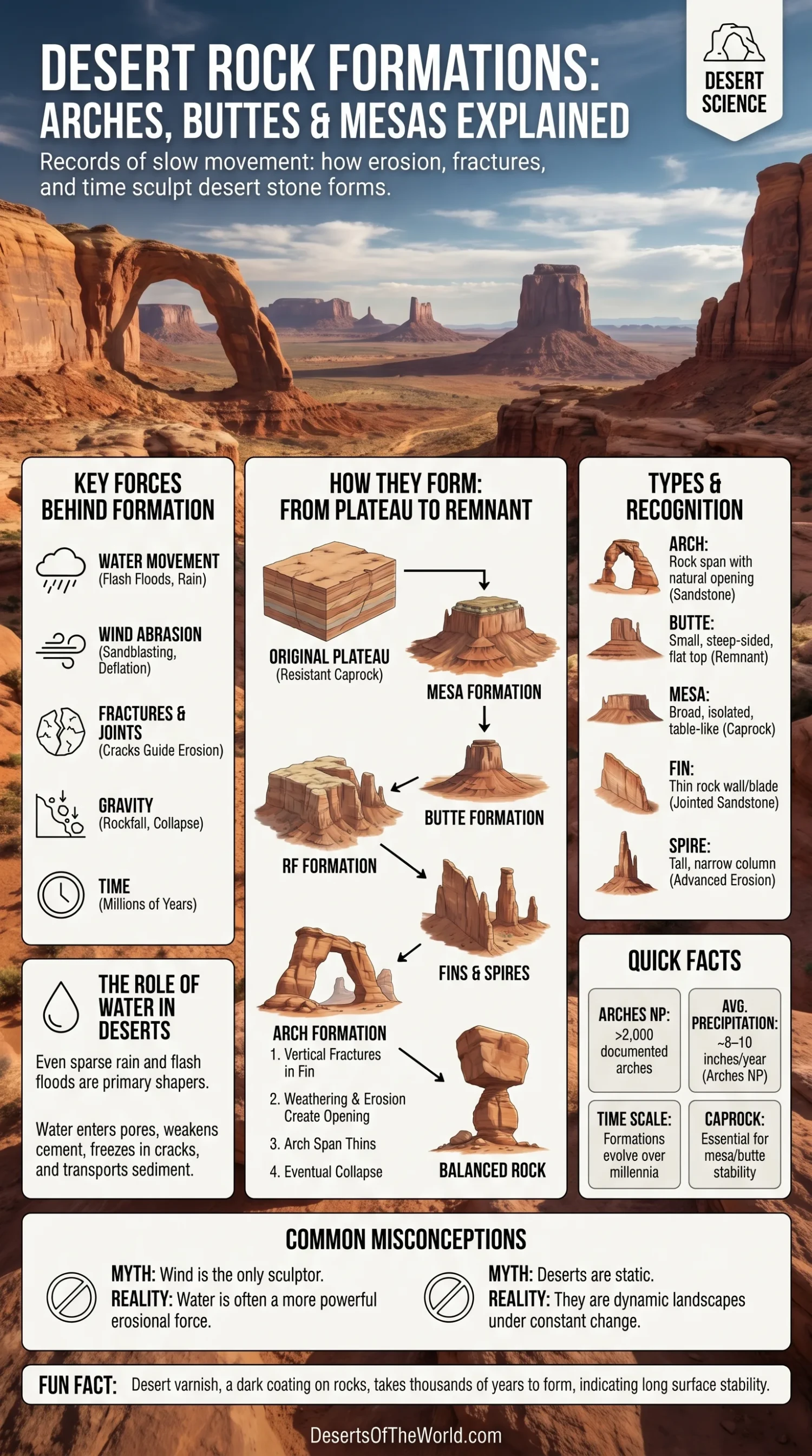
Most desert rock formations are not random shapes. They form where rock type, climate, erosion, water movement, fractures, and time meet in the right order. A mesa may begin as part of a broad plateau. A butte may remain after a mesa shrinks. A fin may split from a sandstone wall. An arch may open through that fin when weathering weakens the stone from within.
The shape is the clue. Flat tops often point to resistant caprock. Steep sides suggest that softer layers beneath have worn away. Narrow openings in sandstone show where cracks, water, salt, frost, and gravity have worked together. Desert landforms are like pages in a stone book: each layer tells where the sediment came from, how it was buried, and how it returned to the open air.
| Formation | Basic Shape | Main Process | Common Desert Setting |
|---|---|---|---|
| Arch | Rock opening with a natural span | Weathering and erosion along cracks, fins, and weaker zones | Sandstone deserts, dry plateaus, canyon country |
| Butte | Small, steep-sided, often flat-topped hill | Remnant left after a mesa or plateau is eroded | Arid and semi-arid plateau regions |
| Mesa | Broad, isolated, flat-topped highland | Plateau erosion with resistant caprock left on top | Dry basins, canyonlands, sedimentary plateaus |
| Fin | Thin wall or blade of rock | Jointed sandstone eroded into narrow ridges | Sandstone landscapes with parallel fractures |
| Spire or Pillar | Tall, narrow rock column | Advanced erosion of buttes, fins, or cliff edges | Badlands, canyon margins, dry escarpments |
| Balanced Rock | Large block resting on a narrower base | Differential erosion of harder and softer layers | Layered sandstone and desert plateau terrain |
Why Deserts Expose Rock Formations So Clearly
Deserts are often described by lack of rain, but their rock scenery is shaped by more than dryness. Sparse plant cover leaves cliffs, ridges, and stone surfaces visible. Flash floods can cut channels quickly. Wind removes loose particles and polishes exposed surfaces. Daily temperature swings stress rock faces. In some places, salt crystals grow inside tiny openings and pry grains apart.
Water still matters in deserts. In fact, many desert landforms depend on short, repeated contact with water. A rare storm can soak sandstone, fill cracks, move sand, and send runoff through a wash. After the water leaves, evaporation may concentrate salts. Later, wind clears loosened grains. The desert does not need constant rain to reshape rock. It only needs the right events, repeated over long spans of time.
Weathering and Erosion Are Not the Same
Weathering breaks rock down where it sits. Erosion moves the broken material away. That difference matters.
- Physical weathering breaks rock through heating, cooling, frost wedging, salt growth, and pressure release.
- Chemical weathering changes minerals through reactions with water, oxygen, weak acids, or dissolved salts.
- Erosion removes the loosened grains, blocks, and sediment by water, wind, gravity, or ice.
A sandstone wall can weaken for centuries before a visible piece falls. Quiet work first. Then a sudden change.
How Natural Arches Form in Desert Landscapes
A natural arch is a rock span with an opening beneath it. In desert sandstone country, many arches begin as vertical fractures in thick rock layers. Those fractures widen into narrow fins. Weathering then attacks the weaker parts of the fin until an opening forms. The opening may grow wider as loose grains and blocks fall away.
Wind plays a role, especially in removing sand and abrading exposed surfaces, but it is rarely the only sculptor. Many short explanations give wind too much credit. In most sandstone arch landscapes, water is deeply involved: rainwater seeps into pores, dissolves mineral cement, freezes in cracks where the climate allows it, and weakens the rock from inside.
The Arches National Park Example
Arches National Park in Utah is one of the clearest places to understand desert arch formation. It contains more than 2,000 documented natural stone arches. The park also receives only about 8 to 10 inches of precipitation in an average year, yet that small amount is enough to keep weathering active.
The park’s most famous arches are mainly associated with the Entrada Sandstone, a porous Jurassic sandstone. Beneath it lies the less porous Carmel layer. Rainwater can enter the Entrada more easily, then collect above the denser layer below. That trapped water weakens the cement between sand grains. In cold periods, water in cracks may freeze and expand. Over time, small cavities become larger openings.
There is also a deeper structural reason. Buried salt layers once shifted and bulged under pressure, bending the overlying rock. The sandstone cracked into long, roughly parallel joints. Those joints guided later erosion. Without that crack pattern, the same rock would not produce the same maze of fins and arches.
The Life Cycle of a Sandstone Arch
- A thick sandstone layer develops vertical joints or fractures.
- Erosion widens the joints and separates the rock into narrow fins.
- Water enters pores and cracks, weakening mineral cement.
- Small alcoves form on one or both sides of a fin.
- The alcoves meet, creating an opening.
- The span thins as weathering continues.
- Eventually, the arch collapses and leaves pillars, blocks, or a broken ridge.
An arch is not a finished object. It is a stage.
Arches and Natural Bridges Are Related but Not Identical
People often use “arch” and “natural bridge” as if they mean the same thing. They are related, but the usual distinction is process. A natural bridge is commonly linked to stream erosion, where flowing water cuts through rock and leaves a span. A natural arch can form through several processes, including weathering along sandstone fins, coastal erosion, or collapse around weaker zones.
In desert regions, this difference helps explain why some openings stand high on dry ridges while others sit near washes or former watercourses. The shape may look similar, but the story behind it can be different.
What Makes a Butte Different from a Mesa?
A butte is usually smaller than a mesa, with a narrower top and steep sides. A mesa is broader, flatter, and more table-like. Both are common in arid and semi-arid regions because layered rocks and limited vegetation make erosion patterns easy to see.
There is no single worldwide size rule that separates every butte from every mesa. The terms are descriptive. If the flat summit is broad and table-like, “mesa” usually fits better. If the feature stands more like an isolated tower or small flat-topped hill, “butte” is usually the clearer word.
| Feature | Mesa | Butte |
|---|---|---|
| Top Shape | Broad and flat, like a table | Smaller flat top or narrow summit |
| Size | Larger landform | Smaller remnant |
| Sides | Steep slopes or cliffs on one or more sides | Steep sides on most or all sides |
| Typical Origin | Eroded plateau remnant | Eroded mesa remnant or isolated hard-capped hill |
| Main Protective Layer | Resistant caprock | Resistant caprock, if still preserved |
How Mesas Form
Mesas often begin as part of a plateau or broad upland. The surface is protected by a resistant rock layer, often sandstone, limestone, lava, conglomerate, or another hard unit. Around it, water and wind remove softer material. Valleys cut downward. Cliff edges retreat. The once-continuous plateau becomes a set of isolated, flat-topped masses.
The caprock is the shield. Under it, softer layers may be carved more quickly. This produces the classic mesa form: a flat top, steep sides, and a visible stack of sedimentary beds.
Why Mesas Are Common in Dry Plateau Regions
Dry regions often preserve exposed layers in a clean, readable way. On the Colorado Plateau, for example, flat-lying sedimentary rocks, high elevation, deep canyons, and limited plant cover create ideal conditions for mesas, buttes, cliffs, benches, and spires. Similar landform logic appears in many drylands outside North America, including parts of the Sahara, the Arabian deserts, the Namib margin, and the desert plateaus of central Asia.
The names may change by language and region. The processes remain familiar.
How Buttes Form
A butte is often the next erosional step after a mesa. As the edges of a mesa retreat, its summit narrows. Blocks fall from the caprock. Slopes develop below the cliff line. If enough of the mesa disappears, a smaller isolated remnant remains: a butte.
Buttes are not always perfectly flat. Some have uneven tops or broken caps. Others stand as clean, geometric towers. The most stable ones usually keep a protective layer on top. Once that caprock is removed, the softer rock below can wear away faster.
Caprock Controls the Shape
Caprock is a harder layer that protects weaker rock beneath it. It may be a tough sandstone bed, a lava flow, a cemented conglomerate, or another erosion-resistant unit. In desert scenery, caprock often creates sharp visual contrast: a hard rim above softer slopes.
Think of a roof over sun-dried clay. As long as the roof stays in place, the material below lasts longer. When the roof breaks, the exposed part begins to fail. Simple, but powerful.
Fins, Spires, Pinnacles, and Balanced Rocks
Arches, buttes, and mesas are easier to understand when seen with nearby landforms. Desert landscapes rarely produce one shape in isolation. A single sandstone area may contain fins, arches, alcoves, tafoni, spires, cliffs, benches, and talus slopes within a short walk.
Fins
Fins are narrow rock walls, often formed where fractures divide thick sandstone into parallel slabs. They are important because many sandstone arches begin inside fins. The fin stage shows the rock before the opening forms.
Spires and Pinnacles
Spires and pinnacles are narrow vertical remnants. They may form from the breakdown of fins, buttes, cliff edges, or badland slopes. Where softer layers erode around harder cores, these towers can stand for long periods before gravity claims them.
Balanced Rocks
Balanced rocks form when a harder block rests on a softer pedestal. The lower layer erodes faster, creating a narrow base. The upper block may look carefully placed, but the shape is natural. It is differential erosion made visible.
The Main Forces Behind Desert Rock Formations
Differential Erosion
Differential erosion means some rocks wear away faster than others. This is the heart of many desert landforms. Hard caprock remains. Soft shale, weak sandstone, or clay-rich layers retreat. The result may be a mesa, butte, ledge, hoodoo, or cliff band.
Jointing and Fractures
Joints are cracks in rock where there has been little or no movement along the crack surface. They guide water, root growth, ice formation, and erosion. In sandstone deserts, joint patterns can decide where fins, narrow canyons, and arches appear.
Porosity and Cement
Sandstone is made of grains held together by natural cement such as calcite, silica, or iron minerals. If the rock is porous, water can move through it. If that water dissolves cement or carries salts, the stone weakens grain by grain.
Salt Weathering
Salt weathering is common in dry regions. Water carrying dissolved salts enters pores and cracks. As the water evaporates, salt crystals grow. Their pressure can loosen grains and peel surfaces. This process can help create pits, honeycomb textures, and fragile crusts on sandstone.
Freeze-Thaw Action
Not all deserts are hot year-round. Cold deserts and high desert plateaus can have freezing nights or winter snow. When water freezes inside cracks, it expands. Repeated freezing and thawing can pry rock apart. In high desert sandstone country, this is one reason cliffs shed blocks and arches slowly thin.
Wind Abrasion and Deflation
Wind can move sand, dust, and small grains across open ground. It wears exposed rock through abrasion and removes loose particles through deflation. Wind is especially active where vegetation is sparse and dry sediment is available. Still, wind usually works with earlier weakening by water, salts, fractures, and gravity.
Desert Varnish: The Dark Skin on Many Rock Faces
Many desert cliffs and boulders carry dark brown, black, reddish, or orange coatings known as desert varnish. These coatings often contain clay minerals, iron oxides, manganese oxides, and other surface materials. They form slowly on stable rock surfaces, especially in arid and semi-arid settings.
Desert varnish can make rock faces look older, darker, or streaked after rain. It also tells a useful geomorphic story: the surface has likely remained exposed and fairly stable for a long time. Fresh breaks, recent rockfalls, and newly eroded surfaces often look lighter because the coating has not developed there yet.
Where These Formations Appear Around the World
The American Southwest is famous for arches, buttes, and mesas, but desert rock formations are global. Similar shapes appear wherever dry climate, exposed bedrock, layered sediment, resistant caps, and erosion meet.
| Region | Notable Landform Types | Why the Area Fits the Topic |
|---|---|---|
| Colorado Plateau, United States | Arches, mesas, buttes, fins, canyons, spires | Layered sedimentary rocks, sandstone cliffs, dry climate, and long erosion history |
| Sahara Desert Margins | Rock plateaus, inselbergs, wind-cut forms, desert varnish | Broad exposed bedrock areas shaped by wind, water, and long dry periods |
| Wadi Rum, Jordan | Sandstone cliffs, domes, narrow canyons, rock bridges | Large sandstone masses cut by joints, weathering, and erosion |
| Ennedi Plateau, Chad | Natural arches, towers, sandstone massifs | Desert sandstone shaped by weathering, runoff, and wind exposure |
| Namib Desert Margins | Inselbergs, gravel plains, wind-shaped rock surfaces | Long-term aridity, exposed bedrock, and strong aeolian processes |
| Central Asian Drylands | Badlands, mesas, cliffs, eroded sedimentary hills | Dry basins with soft sedimentary rocks and active erosion |
Why Layered Sedimentary Rock Creates Such Clear Shapes
Many desert rock formations form in sedimentary rocks because sedimentary layers often vary in hardness. A sandstone bed may resist erosion. A shale layer below it may crumble faster. A limestone cap may protect a softer slope. These contrasts allow erosion to carve sharp forms rather than smooth hills.
Layering also gives the eye a scale. A cliff face may show cross-bedding from old dunes, flat bedding from quiet water, ripple marks from shallow flow, or mud cracks from drying surfaces. In desert country, the rock is often bare enough to read these features directly.
Cross-Bedding and Ancient Dunes
Cross-bedding appears as angled layers inside sandstone. It often records old dune slopes or flowing water. In desert sandstone, cross-bedding can reveal a time when loose sand moved across an ancient landscape before burial turned it into rock.
Talus Slopes and Rockfall Aprons
At the base of many cliffs and buttes, broken rock gathers in sloping piles called talus. These piles are not just debris. They show active erosion. Fresh blocks may have sharp edges and lighter surfaces. Older pieces may darken with varnish and settle into the slope.
Why Some Formations Last and Others Fall
Rock formations last when their internal structure can carry weight and resist weathering. They fail when cracks widen, supports thin, undercutting deepens, or water weakens the cement inside the rock. Gravity waits for the weak moment.
Large arches can stand for thousands of years, then lose a slab in seconds. A butte may keep its caprock for a long period, then shrink quickly after the cap breaks. A balanced rock may seem impossible until the pedestal finally gives way.
This is normal landform change, not damage in the human sense. Desert rock formations are temporary shapes in a long erosion sequence.
How To Read a Desert Rock Formation
A desert rock formation becomes easier to understand when viewed through a few simple questions.
- Is the top flat? A flat top often suggests caprock or former plateau surface.
- Are the sides steep? Steep sides may show resistant layers over softer beds.
- Are there vertical cracks? Cracks guide fins, narrow canyons, arches, and rockfall.
- Is there a dark surface coating? Desert varnish may point to long exposure and surface stability.
- Is broken rock gathered below? Talus shows active cliff retreat.
- Does the opening sit in a fin or near a wash? That can help distinguish arch-forming weathering from stream-cut bridge formation.
Common Misunderstandings About Desert Rock Formations
Wind Does Not Create Every Desert Shape Alone
Wind is visible and easy to imagine, so it often gets too much credit. It can abrade, polish, and move sediment, but many arches, mesas, and buttes depend on water, fractures, caprock, mineral cement, salt weathering, and gravity.
Deserts Are Not Always Too Dry for Erosion
Dry landscapes can erode quickly during short storms. Flash runoff can move sediment, cut channels, and undercut slopes. Long dry pauses may follow, but the next storm continues the work.
Buttes Are Not Just Small Mountains
A butte is better understood as an erosional remnant, often tied to a former mesa or plateau. Its form says more about erosion and rock layers than simple height.
Mesas Are Not Flat Because Nothing Happened
A mesa’s flat top often survives because a resistant layer protected it while surrounding material wore down. The flatness is not emptiness. It is evidence.
Helpful Terms for Desert Rock Formations
| Term | Meaning |
|---|---|
| Caprock | A hard upper layer that protects softer rock below from faster erosion. |
| Differential Erosion | Uneven erosion caused by differences in rock hardness, structure, or exposure. |
| Joint | A natural crack in rock that can guide water, weathering, and erosion. |
| Fin | A narrow wall of rock, often formed from fractured sandstone. |
| Talus | Loose rock fragments collected at the base of a cliff or steep slope. |
| Desert Varnish | A dark surface coating on exposed rock, often made from clay minerals and iron or manganese oxides. |
| Aeolian | Related to wind activity, especially wind erosion, transport, or deposition. |
| Weathering | The breakdown of rock in place by physical or chemical processes. |
| Erosion | The removal and transport of weathered material by wind, water, gravity, or ice. |
Why These Formations Matter in a Desert Knowledge Site
Arches, buttes, and mesas are more than scenic objects. They help explain how deserts work. They show past environments, old dunes, vanished seas, uplifted plateaus, changing drainage, and the slow exposure of buried stone. They also make desert maps easier to understand because landforms often guide routes, viewpoints, drainage lines, and habitat edges.
In a sandy desert, dunes may dominate the view. In a rocky desert, stone does. Many real deserts contain both. The best way to understand them is not to separate sand from rock too sharply, but to see how wind, water, sediment, and bedrock keep trading roles.
Sources
- National Park Service – Arches (formation of natural arches, Entrada Sandstone, Carmel layer, precipitation, and documented arch count)
- U.S. Geological Survey – Geology of Arches National Park (sandstone layers, arch formation, salt anticlines, desert varnish, and regional uplift)
- National Park Service – Arches, Buttes and Rock Formations (definitions of mesas, buttes, plateaus, pillars, spires, fins, and related landforms)
- National Park Service – Plateaus and Mesas (plateau and mesa formation, caprock, and erosion of elevated flat surfaces)
- U.S. Geological Survey – Eolian Processes (wind erosion, deflation, abrasion, desert pavement, ventifacts, and arid-land surface processes)
- National Park Service – Desert Varnish (rock coatings, varnish composition, desert occurrence, and surface stability)
- National Park Service – Weathering and Erosion (difference between weathering and erosion, physical weathering, chemical weathering, wind, water, salt, and ice effects)