An immense sea of sand in China’s Xinjiang Uyghur Autonomous Region, the Taklamakan is one of Earth’s largest shifting-sand deserts—famous for towering dunes, extreme aridity, Silk Road ruins, and the life-giving Tarim River skirting its edge.
Location & Continent
Continent: Asia
Country: China (Xinjiang Uyghur Autonomous Region)
Coordinates: ~38°N, ~83°E
Taklamakan – Map & Street View
Photos of the Taklamakan Desert

Physical Features
Area: ~337,000 km² (among the world’s largest sand deserts)
Length: ~1,000 km (east–west)
Width: ~400–500 km (north–south)
Elevation: ~800–1,300 m above sea level across the Tarim Basin floor
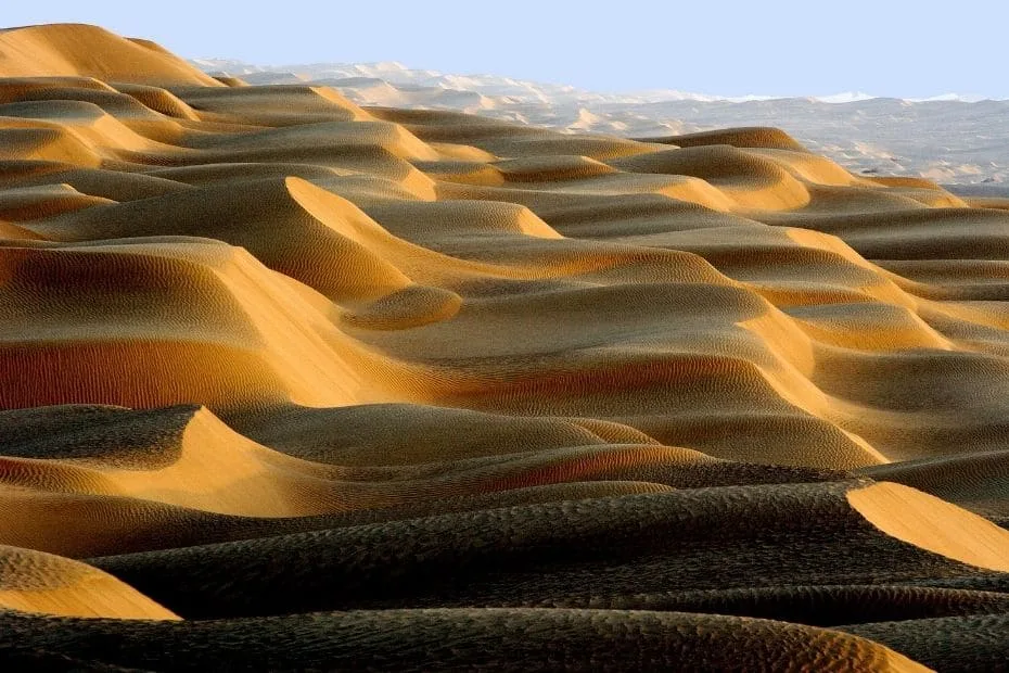
Dune Types: Star, barchan, and linear megadunes; many exceed 100–200 m in height
Climate & Precipitation
Temperature: Summer highs commonly 45–50 °C; winter lows −20 to −30 °C in interior basins
Precipitation: Typically < 50 mm annually; interior zones can receive < 10 mm—extreme aridity with high evaporation
Winds & Sandstorms: Seasonal strong winds sculpt dunes and drive frequent dust events
Ecological Features
Ecozone: Palearctic (cold desert and steppe transition)
Biome: Temperate desert and xeric shrubland with saline playas
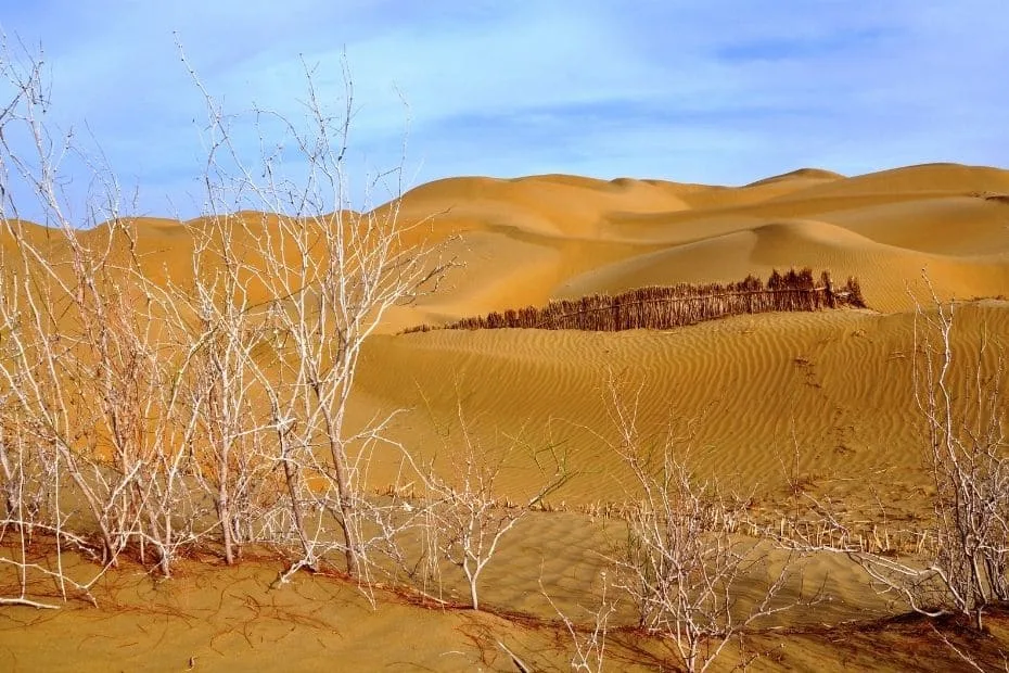
Riparian Oases: Populus euphratica (desert poplar) and tugai woodlands along the Tarim and Hotan river corridors
Flora & Fauna
Flora: Saxaul (Haloxylon ammodendron), Tamarix, Ephedra, Salsola (saltworts), Nitraria, and ephemeral wildflowers after rare rains; reedbeds near springs and river margins
Fauna: Wild Bactrian camel (critically endangered pockets), goitered gazelle, onager (Asiatic wild ass) in adjoining steppe, corsac fox, jerboas, hedgehogs, reptiles such as desert monitor and sand lizards, and raptors including saker falcons; migratory birds concentrate at oasis lakes
Geology & Notable Features
Geology: Endorheic Tarim Basin bounded by the Kunlun, Pamir, and Tian Shan ranges; vast aeolian sand seas over ancient alluvial and lacustrine sediments; salt flats and clay pans in interdune depressions
Notable Features: Tarim River green corridor; Taklamakan Desert Highway with massive shelterbelt forests; archaeological sites at Niya, Loulan, and Miran on the margins; nearby oil and gas fields; historical Silk Road caravan routes skirting the desert’s northern and southern rims
Overview
The Taklamakan Desert sits like a golden ocean at the heart of the Tarim Basin. Rimmed by high mountain ranges that block moist air,
it is intensely dry, with towering dunes that shift under powerful seasonal winds. Human life clusters at the edges where rivers
such as the Tarim, Yarkand, and Hotan create oases—fertile waystations on Silk Road routes that once funneled goods and ideas between
East and West. Modern engineering has carved a highway through the sands, protected by long belts of drought-tolerant trees and shrubs.
Despite its reputation as “the place you go in and don’t come out,” life persists here. Desert poplars endure in salty soils; saxaul
stabilizes dunes; and wildlife threads the sparse vegetation and oasis wetlands. The Taklamakan isn’t empty so much as exquisitely selective,
rewarding the rare rain with short-lived blooms and sheltering ancient histories beneath its dunes.
References
Government / Official & Intergovernmental
Chinese Academy of Sciences (CAS) — Research briefs on Tarim Basin deserts, dune dynamics, and oasis ecology
China Meteorological Administration — Climate characteristics of Xinjiang’s arid basins (temperature, precipitation, dust storms)
UNESCO World Heritage Centre — Silk Roads corridors around the Tarim Basin (oasis towns and archaeological contexts)
U.S. Geological Survey (USGS) — Remote sensing and geomorphology of Central Asian deserts and endorheic basins
University / Scholarly
Lanzhou University & collaborators — Quaternary evolution of the Tarim Basin and Taklamakan aeolian systems
Chinese Academy of Sciences / Springer — Desert poplar (Populus euphratica) ecology and riparian restoration in the Tarim corridor
Wiley journals — Dust emission, dune morphology, and oasis–desert interactions in the Taklamakan
Wikipedia
Introduction
The Taklamakan Desert is one of the largest sandy deserts in the world, covering about 337,000 square kilometers. It lies within the Taklamakan Basin in Xinjiang, China, and is defined by extensive dune fields, an arid climate, and desert-adapted species. This section compares the Taklamakan Desert with other major deserts, focusing on its geography, climate, flora and fauna, and cultural context.

Geography
The Taklamakan Desert is bordered by mountain ranges, including the Tianshan Mountains to the north and the Kunlun Mountains to the south. These surrounding ranges create a rain shadow that limits precipitation and shapes the desert’s climate. Key geographical features include:
| Feature | Description |
|---|---|
| Area | 337,000 square kilometers |
| Location | Northwest China, Xinjiang |
| Surrounding Mountains | Tianshan (North), Kunlun (South) |
| Elevation | Approximately 1,000 meters above sea level |
| Sand Dunes | Some reaching heights of up to 300 meters |
Climate
The Taklamakan Desert experiences a harsh desert climate with extreme temperatures ranging from scorching highs of 49°C (120°F) in the summer to frigid lows of -20°C (-4°F) in the winter. Precipitation levels are notably low, averaging around 3 to 5 centimeters annually. The climate influences the desert’s ecosystem and its inhabitants:
- Temperature Range: Extreme fluctuations create diverse habitats.
- Precipitation: Limited rainfall resulting in arid conditions.
- Wind Patterns: Strong winds contribute to the shifting of sand dunes.
Flora and Fauna
Despite its harsh climate, the Taklamakan Desert is home to a surprising variety of life adapted to survive in such conditions. Featured species include:
- Flora: Saltbush, Tamarisk, and Scorzonera are prevalent plants that have evolved to thrive in high salinity and arid conditions.
- Fauna: Animals such as the elusive Bactrian camel, desert foxes, and various rodents are notable residents of the desert.
In comparison to other deserts, the biodiversity of the Taklamakan stands out due to its unique adaptations. Here’s a quick comparison with two other notable deserts:
| Desert | Area | Climate | Flora & Fauna |
|---|---|---|---|
| Taklamakan Desert | 337,000 km2 | Extreme temperatures, low precipitation | Bactrian camel, Tamarisk |
| Sahara Desert | 9,200,000 km2 | Hot, dry, with seasonal rains | Fennec fox, Acacia trees |
| Gobi Desert | 1,295,000 km2 | Harsh winters, hot summers | Gobi bear, shrubs |
Cultural Significance
The Taklamakan Desert has shaped the history and culture of the surrounding regions, including communities of the Uighur people. Many settlements developed along sections of the Silk Road that crossed the desert:
- Cultural Heritage: The Silk Road facilitated trade and cultural exchanges between East and West.
- Traditional Livelihoods: Nomadic herding practices among the Uighurs have deep connections to the desert landscape.
- Environmental Adaptations: Local communities have developed unique methods of water use and sustainable farming.
Conclusion
The Taklamakan Desert reflects the interaction of desert ecosystems, climate patterns, and regional cultures. Although conditions are harsh, it supports plant and animal species adapted to arid environments and has influenced human settlement and trade in surrounding areas. The desert illustrates the range of environments and life forms found across the planet.