
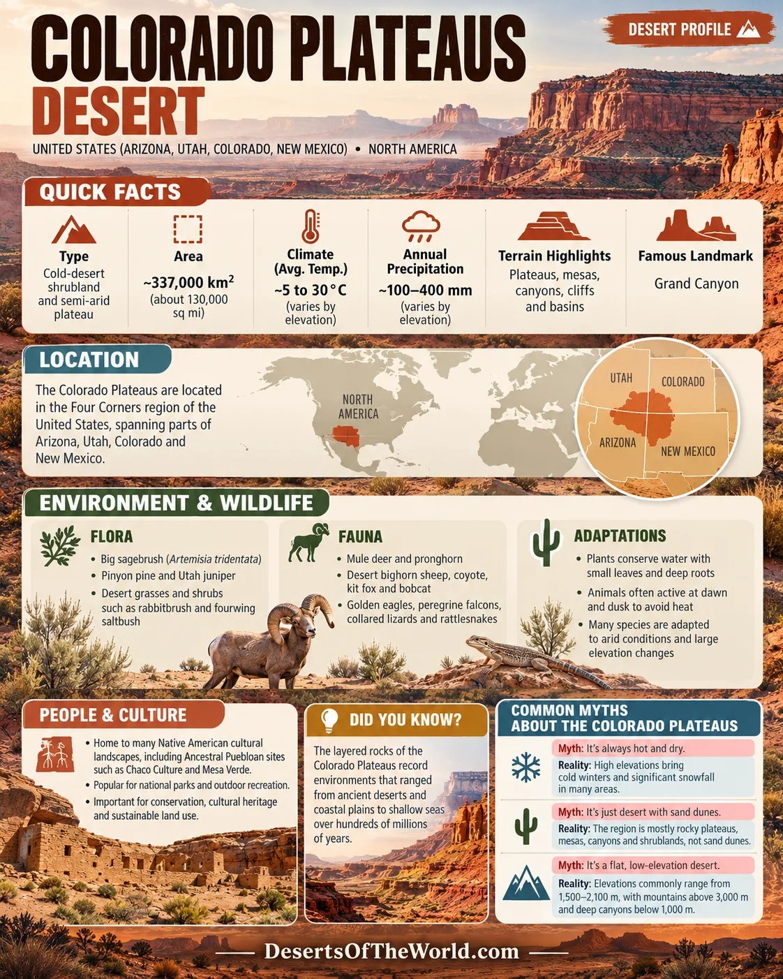
Location & Continent
Continent: North America
Country: United States (Arizona, Utah, Colorado, New Mexico)
Coordinates: ~36°N, 111°W
Colorado Plateau – Map & Street View
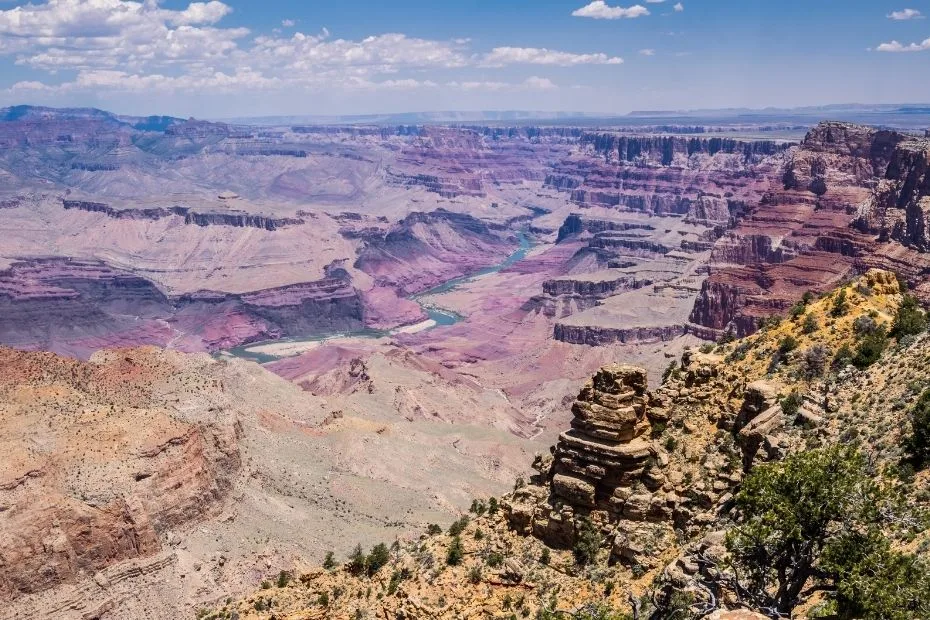
Photos of the Colorado Plateau
Physical Features
Area: ~337,000 km² (about 130,000 sq mi for the Colorado Plateaus physiographic province)
Length: ~600–700 km north–south
Width: ~400–500 km east–west
Elevation: Plateau surfaces commonly lie about 1,500–2,100 m above sea level, while canyon bottoms descend below 1,000 m and mountain areas rise above 3,000 m
Climate & Precipitation
Temperature: Hot summers occur in lower canyons and basins, while winters are cold on high plateaus and mountain margins
Precipitation: Generally low and strongly affected by elevation; winter storms and the late-summer North American Monsoon provide much of the region’s moisture
Ecological Features
Ecozone: Nearctic
Biome: Cold-desert shrubland and semi-arid steppe grading into pinyon–juniper woodland and montane conifer forest at higher elevations
Ecoregions: EPA Level III Colorado Plateaus and related Colorado Plateau shrubland systems, with transitions toward the Great Basin, Arizona/New Mexico Mountains, and surrounding desert regions
Flora & Fauna
Flora: Big sagebrush (Artemisia tridentata), blackbrush (Coleogyne ramosissima), fourwing saltbush (Atriplex canescens), rabbitbrush (Ericameria), Mormon tea (Ephedra viridis), galleta grass, Indian ricegrass, pinyon pine (Pinus edulis), and Utah juniper (Juniperus osteosperma)
Fauna: Mule deer, pronghorn, desert bighorn sheep, coyote, kit fox, bobcat, mountain lion, collared lizards, whiptails, rattlesnakes, golden eagles, peregrine falcons, canyon wrens, and ravens
Geology & Notable Features
Geology: Thick sequences of Paleozoic and Mesozoic sandstone, limestone, shale, and other sedimentary rocks were uplifted across the plateau and later dissected by the Colorado River and its tributaries. Volcanic fields and igneous intrusions occur in several parts of the province.
Notable Features: Grand Canyon, Canyonlands, Arches, Capitol Reef, Zion, Bryce Canyon, and Petrified Forest National Parks; Monument Valley; Glen Canyon; the Colorado and Green river systems; Chaco Culture and Mesa Verde cultural landscapes
Colorado Plateau: High Desert, Canyons and Layered Rock
The Colorado Plateau is an uplifted region centered on the Four Corners area of Arizona, Utah, Colorado, and New Mexico. Much of its landscape consists of broad plateaus and mesas separated by cliffs, basins, buttes, and deeply incised canyons. Sedimentary layers exposed along canyon walls record environments that ranged from deserts and coastal plains to shallow seas.
Elevation strongly affects climate and vegetation. Lower areas support shrublands, desert grasslands, and warm canyon environments, while pinyon–juniper woodland is widespread at middle elevations. Ponderosa pine, Douglas-fir, aspen, and other montane vegetation occur on higher plateaus and mountains.
The Colorado River and its tributaries are central to the region’s present topography. As the plateau was uplifted, rivers cut downward through older rock layers. This process produced canyon systems such as the Grand Canyon and the deeply dissected terrain of Canyonlands and Glen Canyon.
Rain and snow are unevenly distributed across the plateau. Winter storm systems provide snow and rain, especially at higher elevations, while summer monsoon thunderstorms can produce intense local rainfall. Dry washes and slot canyons may flood rapidly even when the storm occurs some distance upstream.
Biological soil crusts occur across many undisturbed dryland surfaces. These communities of cyanobacteria, lichens, mosses, and other organisms stabilize soil and influence water and nutrient cycles. Because they can be damaged by foot and vehicle traffic, remaining on established roads and trails is especially important in crust-covered areas.
Lake Powell Reaches Record-Low Levels in 2026
The effects of the 2025–26 snow drought across the Upper Colorado Basin became visible at Lake Powell during summer 2026. NASA reported that unusually low mountain snow accumulation, weak spring snowmelt and stretches of unusually warm weather reduced the amount of water reaching the reservoir.
Lake Powell first fell below its previous record-low level on August 15, 2026. The earlier record was 3,519.92 ft, set on April 13, 2023. A NASA-USGS Landsat 8 image from September 10, 2026 showed the reservoir at 3,517.24 ft, already below that former record and still declining.
The low level is directly connected to conditions across the Colorado Plateau and the wider Colorado River Basin. Much of the river’s flow originates as mountain snowmelt, so a poor snow season can reduce runoff months later. Lake Powell stores Colorado River water behind Glen Canyon Dam and helps regulate supplies and hydropower operations farther downstream.
Introduction
The Colorado Plateau is a large uplifted region of the southwestern United States covering parts of Arizona, Utah, Colorado, and New Mexico. It contains high-desert basins, mesas, plateaus, cliffs, arches, buttes, badlands, and some of North America’s deepest canyon systems.
Although much of the plateau is arid or semi-arid, it is not a uniform desert. Differences in elevation create a sequence of environments ranging from dry shrublands and grasslands to pinyon–juniper woodland and high-elevation conifer forest.
Geography
The Colorado Plateau covers approximately 337,000 km² in its commonly used physiographic definition. Its interior consists mostly of plateaus, mesas, basins, and canyonlands rather than continuous mountain ranges.
Much of the plateau surface lies between about 1,500 and 2,100 meters above sea level, although elevations vary widely. Deep canyon bottoms are much lower, while volcanic mountains and uplifted plateau margins rise above 3,000 meters.
The Colorado River drainage system cuts across much of the region. Major tributaries include the Green, San Juan, Little Colorado, and Virgin rivers. Repeated river incision has exposed long sequences of sedimentary rock and produced many of the plateau’s major landforms.
Landforms
Some of the best-known landforms and landscapes of the Colorado Plateau include:
- Grand Canyon: A deeply incised canyon system cut primarily by the Colorado River and its tributaries through a long sequence of sedimentary and older basement rocks.
- Monument Valley: A landscape of sandstone buttes and mesas within the Navajo Nation along the Arizona–Utah border.
- Canyonlands: A heavily dissected region in southeastern Utah shaped by the Colorado and Green rivers and their tributaries.
- Arches: Concentrations of natural sandstone arches formed through erosion, fracturing, and weathering of Entrada Sandstone and related formations.
- Bryce Canyon: Amphitheaters containing dense groups of hoodoos formed by erosion and repeated freeze-thaw processes.
Climate
The Colorado Plateau has predominantly arid to semi-arid conditions, but climate changes substantially with elevation and location. Lower canyon areas can become very hot in summer, while high plateaus receive snow and experience prolonged freezing conditions in winter.
| Season | Typical Pattern | Precipitation Pattern |
|---|---|---|
| Winter | Cold on high plateaus; milder in lower desert canyons | Pacific storm systems bring rain and mountain snow |
| Spring | Large day-to-night temperature changes; frequent wind | Often relatively dry between winter storms and the summer monsoon |
| Summer | Hot at lower elevations and milder on higher plateaus | Localized thunderstorms associated with the North American Monsoon |
| Autumn | Warm days and increasingly cold nights | Generally dry, with occasional frontal storms |
Annual precipitation differs sharply with topography. Some lower areas receive only a few hundred millimeters per year, while high plateaus and mountain zones receive substantially more moisture, including winter snowfall.
Ecosystems
Vegetation on the Colorado Plateau follows elevation, soil type, aspect, and available moisture.
- Desert and Shrubland: Blackbrush, saltbush, sagebrush, Mormon tea, rabbitbrush, yucca, prickly pear, and drought-tolerant grasses occur across lower and drier terrain.
- Grasslands: Indian ricegrass, galleta, blue grama, and other grasses occur on plains and open uplands where soil and precipitation permit.
- Pinyon–Juniper Woodland: Pinyon pine and juniper form extensive open woodland across middle elevations.
- Montane Forest: Ponderosa pine, Douglas-fir, fir, spruce, and aspen occur on higher plateaus and mountain slopes.
- Riparian Habitat: Rivers, springs, and perennial streams support cottonwoods, willows, wetlands, and other vegetation uncommon on surrounding dry uplands.
Wildlife varies with these habitat zones. Desert bighorn sheep occupy canyon and rocky desert terrain, while mule deer and mountain lions range across broader elevation zones. California condors are present in parts of the plateau following reintroduction programs, particularly around northern Arizona and southern Utah.
Indigenous and Archaeological Landscapes
The Colorado Plateau contains lands with long-standing and present-day connections to numerous Tribal nations and Indigenous communities. These include the Navajo Nation, Hopi Tribe, Pueblo communities, Southern Paiute peoples, Ute communities, and Zuni Pueblo, among others.
Archaeological sites document thousands of years of human settlement, farming, trade, movement, and ceremonial activity. Chaco Canyon contains large Ancestral Puebloan structures and an extensive road system, while Mesa Verde preserves cliff dwellings and other settlements associated with Ancestral Pueblo peoples.
Many archaeological places are also part of living cultural landscapes rather than solely historical sites. Tribal lands, sacred places, traditional-use areas, and culturally important natural features remain connected to present-day communities. Access rules differ by jurisdiction, and some locations require Tribal permission or are closed to visitors.
Recreation and Access
National parks, national monuments, Tribal parks, national forests, Bureau of Land Management lands, state lands, and other jurisdictions cover large parts of the plateau. Access conditions and rules vary considerably between them.
- Hiking: Major trail systems occur in Grand Canyon, Zion, Canyonlands, Capitol Reef, Arches, and other protected areas.
- River Travel: Sections of the Colorado, Green, and San Juan rivers are used for rafting and other permitted river trips.
- Camping: Developed and backcountry camping is available in many areas, subject to local permits and restrictions.
- Dark-Sky Observation: Low population density and large protected areas provide dark night skies in many parts of the plateau.
Visitors entering remote canyon country should account for heat, limited water, long distances between services, rapidly changing weather, and flash-flood risk. Biological soil crusts, archaeological sites, and culturally sensitive areas should not be disturbed.
Conclusion
The Colorado Plateau is an uplifted, deeply dissected region whose present form reflects the interaction of layered sedimentary rocks, tectonic uplift, erosion, and the Colorado River drainage system. Grand Canyon, Canyonlands, Monument Valley, arches, hoodoos, mesas, and slot canyons represent different expressions of these geological processes.
Elevation also divides the plateau into distinct ecological zones, from dry shrublands and grasslands to pinyon–juniper woodland and high-elevation forest. The same region contains extensive Tribal lands and archaeological landscapes associated with Indigenous communities whose connections to the plateau continue today. These geological, ecological, and cultural features distinguish the Colorado Plateau from the lower deserts surrounding much of its southern and western margins.
References
Government / Official Sources
- National Park Service — Colorado Plateaus Province
- National Park Service — The Colorado Plateau
- National Park Service — Colorado Plateau Geology and Uplift
- U.S. Environmental Protection Agency — Level III Ecoregions of the United States
- National Park Service — Glen Canyon and Colorado Plateau Geology
- NASA Earth Observatory — Lake Powell Drops to Record-Low Levels
- U.S. Bureau of Reclamation — Lake Powell Water Operations
Research Sources
- U.S. Geological Survey — Uplift and River Incision on the Western Colorado Plateau
- National Park Service — Climate and Vegetation Patterns on the Colorado Plateau