The label “South America’s two deserts” works as a shorthand, even though the continent also has other deserts and drylands. These two stand out because they represent two ends of the spectrum: one is the dryness benchmark, the other is the vast southern desert-steppe.
| Feature | Atacama Desert | Patagonian Desert |
|---|---|---|
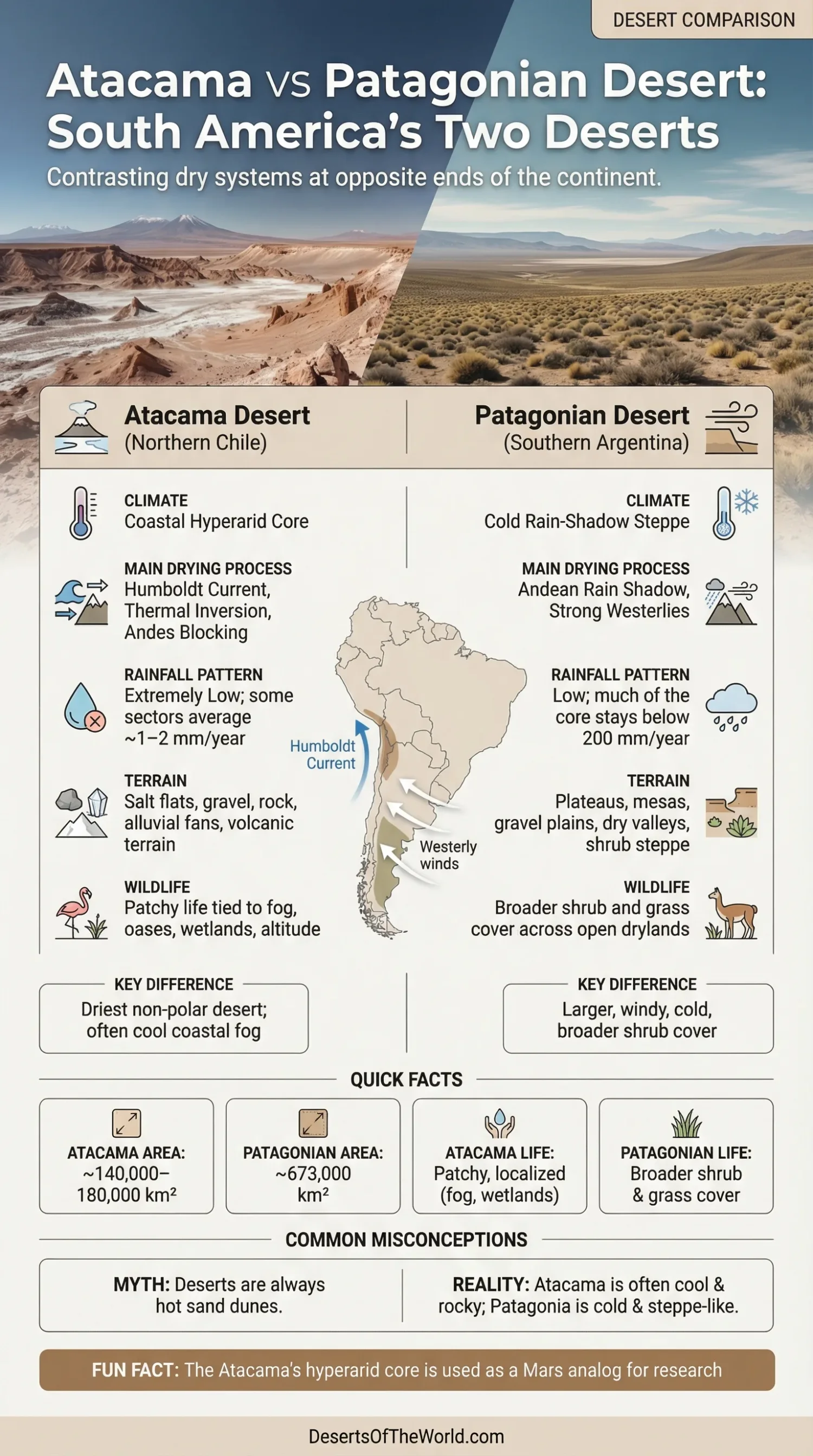
| General Setting | Northern Chile along the Pacific margin | Mostly southern Argentina, east of the Andes |
| Desert Style | Coastal desert with a hyperarid core | Cold desert and steppe desert |
| Approximate Area | Roughly 140,000–180,000 km², depending on the boundary used | About 673,000 km² |
| Main Drying Process | Humboldt Current, thermal inversion, subtropical high pressure, Andean blocking | Andean rain shadow under strong westerly winds |
| Rainfall Pattern | Extremely low; some sectors average around 1–2 mm a year | Low but less extreme; much of the core stays below 200 mm a year |
| Visual Character | Salt flats, gravel, rock, alluvial fans, volcanic terrain | Plateaus, mesas, gravel plains, dry valleys, shrub steppe |
| Ecological Feel | Patchy life tied to fog, oases, wetlands, and altitude | Broader shrub and grass cover across open drylands |
Why The Comparison Matters
Many short summaries reduce the contrast to “Atacama is hot, Patagonia is cold.” That is too thin. The Atacama is often cool for its latitude, especially near the coast, and Patagonia is not just cold. It is windy, open, and steppe-like. Put side by side, these deserts show that desert does not mean one look, one climate, or one kind of ground.
Where Each Desert Sits
Atacama Desert
The Atacama runs through northern Chile, with the broader dry Pacific belt continuing toward southern Peru. In the classic Chilean definition, it stretches for about 1,000 to 1,100 kilometers from north to south. To the west lie coastal mountains and the Pacific. To the east rise the Domeyko Range and the Andes. Between them sit salt basins, interior plains, alluvial fans, and high volcanic margins.
This setting matters. The Atacama is not just a strip of bare sand. It is a layered desert made of coast, cliffs, interior depressions, salars, and high Andean edges.
Patagonian Desert
The Patagonian Desert occupies much of mainland southern Argentina and reaches parts of southwestern Chile in a broader ecological sense. It extends from roughly 37°S to 51°S and spreads eastward from the Andes toward the Atlantic side of Patagonia. In area, it is far larger than the Atacama.
Its form is broad rather than narrow. What stands out here is plateau country: long tablelands, escarpments, gravel surfaces, and open basins under a sky that seems to keep going.
Why They Are Dry For Different Reasons
Atacama Desert: Cold Ocean, Stable Air, And Mountain Barriers
The Atacama stays dry because several controls line up at once. The Humboldt Current cools the air over the Pacific coast. That cooling helps create a thermal inversion: cooler air near the surface, warmer stable air above it. Clouds and fog may form, but rain struggles to develop. Add the South Pacific high-pressure belt and the Andes to the east, and the result is one of the driest regions on Earth.
This is why the Atacama can look cloud-touched near the coast and still stay nearly rainless. Fog matters here. Rain often does not.
Patagonian Desert: Westerlies And Rain Shadow
Patagonia dries out for a different reason. Moist westerly air moves in from the Pacific and rises over the Andes. Much of its moisture falls on the Chilean side and over the Patagonian ice fields. East of the mountains, the descending air is drier, and the Argentine plateau sits in that rain shadow.
The difference across a short west-to-east distance can be sharp. The wet Andean flank receives meters of precipitation, while much of the dry Patagonian steppe farther east stays under 200 millimeters a year. So the Patagonian Desert is not a coastal hyperarid system like the Atacama. It is a lee-side desert, built by mountains and wind.
Climate And Seasonality
The Atacama’s main signature is not heat. It is dryness. In its driest sectors, average rainfall is around 1–2 millimeters a year, and some stations have gone through recorded periods without measurable rain. Coastal temperatures are moderated by the ocean, so the desert often feels milder than many people expect from a place at this latitude.
Patagonia is different again. It is dry, but not to the same extreme. Much of the Patagonian Desert receives less than 200 millimeters of precipitation a year, while some steppe sectors sit around 200–300 millimeters. Frost is common. Snow can fall. And the wind is a constant force. Always there, it feels.
- Atacama: ultra-low rainfall, saline basins, coastal fog, big elevation changes from coast to high plateau.
- Patagonia: low precipitation, cold winters, strong winds, and a broader transition into shrub steppe.
Landforms And Surface Character
Atacama Desert
The Atacama is often imagined as a dune desert. That picture is too narrow. Much of the surface is made of salt pans, gravel, bare rock, alluvial fans, volcanic slopes, and dry basins. Around San Pedro de Atacama, the mix of salar edges, volcanic backdrops, and wind-cut landforms gives the desert its best-known look. In many areas, pebble-covered ground is more common than loose sand.
Elevation changes also shape the land. Low coastal sectors, interior plains, high basins, and Andean volcanic margins all belong to the same desert system. One desert, many levels.
Patagonian Desert
The Patagonian Desert reads differently from the first glance. It is a country of tablelands, basaltic surfaces, gravel spreads, canyons, terraces, and broad plains. The visual rhythm is horizontal. Long distances. Low cover. Hard light.
That is why Patagonia is often described as a steppe desert or cold desert. It is dry, yes, but it is not the near-barren salt-flat world of the Atacama’s hardest core. Its dryness leaves more room for shrubs and grasses to hold on across wide areas.
Plants And Wildlife
Life In The Atacama
In the Atacama, living systems gather wherever moisture can be trapped. Coastal fog supports lomas vegetation on some slopes. River oases interrupt the dryness in a few valleys. High salars and Andean wetlands support flamingos and other birdlife. Higher ground supports animals adapted to thin air and sparse forage, including vicuñas and viscachas.
That patchwork is the real pattern. The Atacama is not empty; it is selective. Life appears where fog, groundwater, wetlands, or altitude create an opening.
Life In The Patagonian Desert
The Patagonian Desert supports broader plant cover than the hyperarid center of the Atacama. Low shrubs, cushion plants, and bunchgrasses dominate large tracts. Genera such as Poa and Stipa help define the grassy side of the steppe, while tougher shrubs handle drought and abrasion from the wind.
Its wildlife suits open-country drylands: guanacos, Patagonian maras, foxes, pumas, burrowing rodents, and steppe birds all belong to this landscape. Here, survival depends less on hidden fog moisture and more on coping with cold, exposure, and uneven forage over distance.
What Makes Atacama Harsher Than Patagonia
If the question is which desert is drier, the answer is the Atacama. Its hyperarid sectors are among the best-known dry benchmarks on Earth and are used in Mars analog research.
If the question is which desert feels larger and more open, Patagonia usually takes that place. It covers far more land and gives a stronger sense of continental scale.
If the question is which desert supports broader everyday vegetation, Patagonia usually does. The Atacama can be biologically sparse over huge stretches, while Patagonia often carries continuous shrub or grass cover even where the land still qualifies as desert or semi-desert.
Human Presence And Land Use
The Atacama is closely linked with mining, salt basins, observatories, and scientific fieldwork. Its dry air, high altitude, and clear skies made northern Chile one of the planet’s best places for astronomy, with major facilities such as ALMA and Paranal tied to the desert environment. Oasis settlements and irrigated pockets exist, but they are the exception rather than the rule.
The Patagonian Desert has a different human profile. It is more closely associated with rangelands, sheep country, scattered towns, and long transport routes across the plateau. Population density is low. Distances are large. The land use pattern reflects that scale.
Atacama Vs Patagonian Desert By Category
| Category | Atacama Desert | Patagonian Desert |
|---|---|---|
| Desert Type | Coastal desert with a hyperarid core | Cold desert and steppe desert |
| Main Drying Mechanism | Humboldt Current, thermal inversion, subtropical high pressure, Andean blocking | Andean rain shadow plus strong westerlies |
| Approximate Area | Roughly 140,000–180,000 km², depending on boundary used | About 673,000 km² |
| Typical Surface | Salt flats, rock, gravel, alluvial fans, volcanic terrain | Plateaus, gravel plains, shrub steppe, mesas, dry valleys |
| Rainfall Pattern | Extremely low; some sectors average around 1–2 mm a year | Low but less extreme; much of the core stays below 200 mm a year |
| Moisture That Still Matters | Fog, groundwater, and rare rain events | Seasonal precipitation, frost, and local snow |
| Vegetation Pattern | Patchy and localized around fog oases, wetlands, and higher sectors | Broader shrub and grass cover across wide steppe tracts |
| Research Identity | Mars analog studies, desert microbiology, high-altitude astronomy | Dryland ecology, wind erosion, and steppe systems |
Why The Usual “Hot Desert Vs Cold Desert” Label Falls Short
It works as a shortcut, but only as a shortcut. The Atacama is not simply a blazing sand desert, and Patagonia is not simply a frozen empty plain. The Atacama is often cool near the coast, foggy in places, and shaped by salars and volcanic basins. Patagonia is dry, cold, and windy, yet often more vegetated than many people expect. Those details are where the comparison becomes accurate.
Seen this way, the pair explains something larger about South America. A desert can form beside a cold ocean under stable air, and another can form thousands of kilometers away behind a mountain wall under the force of westerly winds. Same continent. Very different dry logic.
Sources
- NASA JPL – Detecting Life in the Ultra-dry Atacama Desert (Atacama as the driest non-polar desert and a Mars analog)
- NASA Astrobiology – Astrobiology Field Sites (Atacama environmental conditions, salinity, and low microbial abundance)
- National Geographic Society – South America: Physical Geography (Peru Current, thermal inversion, and Atacama rainfall context)
- Encyclopaedia Britannica – Atacama Desert (extent, landforms, elevation pattern, and climate controls)
- ALMA Observatory – Privileged Location (why the Atacama’s dry, high, clear setting works so well for astronomy)
- USGS – Chile and Argentina: Wet Andes (Patagonian west-to-east rainfall contrast and the Andes rain-shadow effect)
- NASA Earth Observatory – Blowing in the Patagonian Wind (wind and dust activity in the central Patagonian Desert)
- One Earth – Patagonian Steppe (Patagonian climate, soils, vegetation, and representative fauna)
- Encyclopaedia Britannica – Patagonia (Patagonian extent, area, and plateau character)