
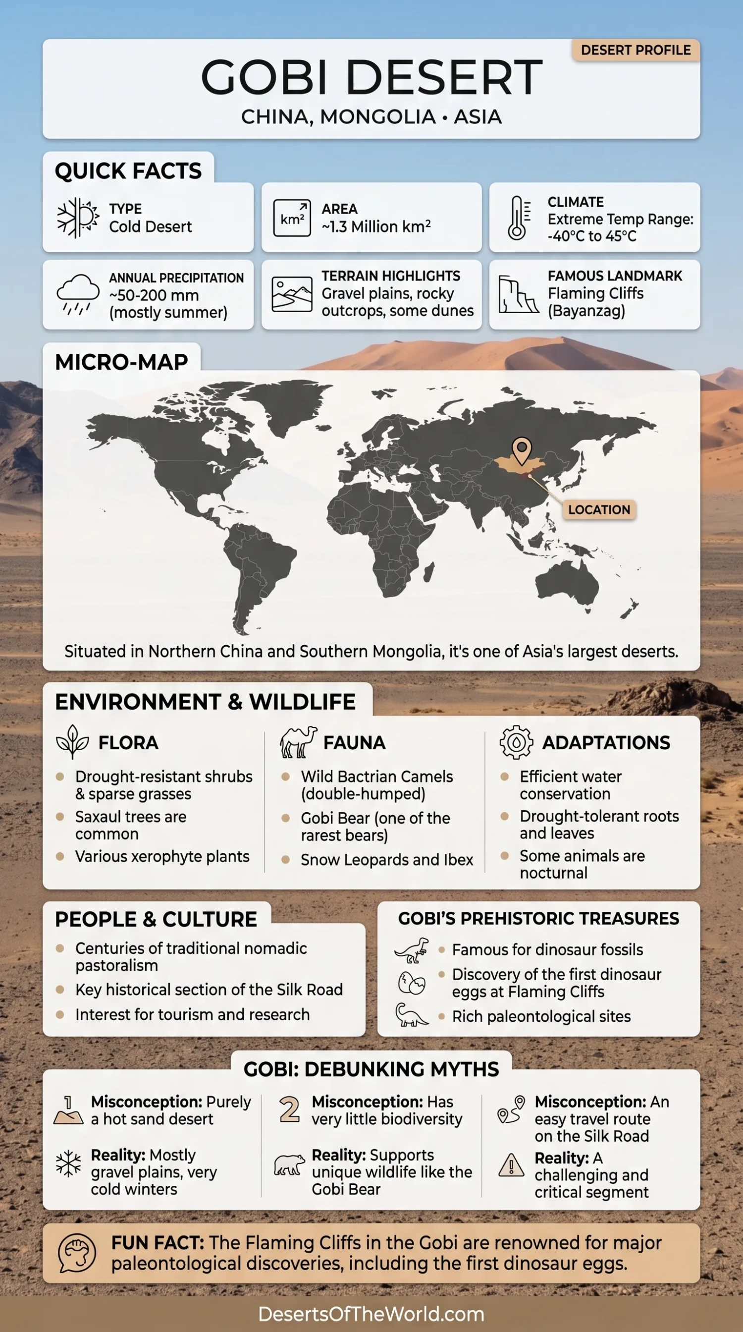
Location & Continent
Continent: Asia
Countries: China, Mongolia
Coordinates: 42°N, 105°E
Gobi Desert – Map & Street View
Photos of the Gobi Desert

Physical Features
Area: Around 1.3 million km² (one of the largest deserts in the world)
Length: Roughly 1,600 km
Width: Around 800 km
Elevation: Commonly around 900–1,500 m above sea level, with higher mountain areas
The Gobi is not an uninterrupted sand sea. Much of its surface consists of gravel plains, rocky ground, dry basins, exposed sediment, and sparsely vegetated steppe. Large dune systems occur in several areas, including Khongoryn Els in southern Mongolia, but sand covers only part of the wider desert landscape.
Climate & Precipitation
Climate: Cold continental desert and semi-desert
Temperature: Summers can reach about 45°C in hotter areas, while severe winter conditions can approach −40°C
Precipitation: Roughly 50–200 mm per year across much of the wider Gobi; many dry areas receive less than 100 mm
The Gobi’s inland position and surrounding mountain systems create a dry continental climate with a very wide seasonal temperature range. Winter precipitation can fall as snow, while warmer-season rainfall contributes a larger share of annual moisture in many parts of Mongolia and northern China.
Rainfall varies considerably across a desert extending more than a thousand kilometres. The driest western and southwestern sectors should therefore not be represented by the same annual precipitation figure as wetter steppe-transition areas.
Why Early-Spring Dust Storms Are Intensifying in the Mongolian Gobi
A 2026 Scientific Reports study examined March dust activity in the Mongolian Gobi using observations and atmospheric data from 2000–2023. The researchers found that early-spring dust activation has intensified in this part of the Gobi even while dust activity has declined across several other East Asian source regions.
The change is linked partly to reduced snow cover and drier soil. Snow normally shields loose ground from wind erosion and helps retain soil moisture as it melts. When March snow cover declines, more bare soil becomes exposed earlier in the season. The darker exposed surface also absorbs more solar energy than snow, encouraging additional warming and evaporation.
Dry ground alone does not produce a dust storm. Strong enough winds and atmospheric instability are also required to lift sediment. The study found that the Mongolian Gobi has retained persistent baroclinic instability and upper-level wind conditions capable of supporting dust uplift. This differs from the Loess Plateau, where weakening atmospheric dynamics can partly offset the effects of surface drying.
The combination matters. In the Mongolian Gobi, earlier snow loss, soil drying, and continued atmospheric instability can occur together during March. Dust occurrence increased markedly after 2020 in the study record, when warmer and drier surface conditions coincided with atmospheric conditions favorable for dust mobilization.
The findings apply specifically to the Mongolian Gobi and early spring, especially March. Dust behavior later in spring can be controlled more strongly by large-scale circulation patterns and individual weather systems, so the mechanism should not be applied uniformly to every season or to the entire Gobi Desert.
Ecological Features
Ecozone: Palearctic
Landscape Types: Cold desert, semi-desert, and dry steppe
Biomes: Temperate desert and xeric shrubland, with temperate grassland and steppe transition zones
Ecoregions: Eastern Gobi Desert Steppe, Alashan Plateau Semi-Desert, Gobi Lakes Valley Desert Steppe
The Gobi covers several ecological regions rather than one uniform habitat. Gravel deserts, dry valleys, mountain slopes, dune fields, saline basins, and steppe margins each support different plant and animal communities.
Flora & Fauna
Flora: Saxaul, wormwood and other drought-resistant shrubs, salt-tolerant plants, and sparse grasses
Fauna: Wild Bactrian camels, Gobi bears, gazelles, jerboas, wild asses, ibex, snow leopards in mountainous areas, and numerous bird species
Saxaul is one of the characteristic woody plants of Gobi desert environments. Its deep root system and ability to tolerate dry, sandy, and saline soils allow it to survive where plant cover is otherwise sparse. Grasses and low shrubs become more common toward semi-desert and steppe margins.
The wild Bactrian camel is adapted to highly arid parts of the Gobi, while gazelles and wild asses range across broad open landscapes. Ibex and snow leopards are associated more closely with rocky mountain terrain.
The Gobi bear survives in a small population within the Great Gobi A Strictly Protected Area of southwestern Mongolia. Its habitat is tied to remote desert mountains and scattered oasis systems rather than the whole Gobi Desert.
Geology & Notable Features
Geology: Gravel plains, rocky outcrops, sand dunes, dry basins, sedimentary formations, and mountain terrain
Notable Features: Flaming Cliffs (Bayanzag), Khongoryn Els Sand Dunes, Nemegt Basin, and Yolyn Am
The Gobi contains extensive sedimentary basins that preserve fossils from several periods of Earth’s history. Wind and water erosion have exposed layers that contain dinosaur, reptile, mammal, and other vertebrate remains.
Flaming Cliffs and Dinosaur Fossils
Bayanzag, widely known as the Flaming Cliffs, is one of the best-known fossil localities in the Mongolian Gobi. American Museum of Natural History expeditions led by Roy Chapman Andrews worked in the region during the 1920s and recovered dinosaur fossils, nests, eggs, mammals, and reptiles.
The wider Gobi remains an active paleontological research region. The Nemegt Basin and other sedimentary formations preserve additional fossil assemblages that have helped document prehistoric ecosystems in Central Asia.
Gravel Plains, Dunes, and Mountain Valleys
Much of the Gobi consists of firm stony or gravel surfaces rather than loose sand. Wind removes finer material from exposed ground, leaving coarse gravel and rock fragments behind in many areas.
Large dunes still occur locally. Khongoryn Els forms one of Mongolia’s best-known dune systems, while Yolyn Am represents a very different Gobi environment: a narrow mountain gorge within the Gobi Altai landscape.
Human Geography and Historical Routes
Pastoral communities have lived across the Mongolian Gobi and its steppe margins for centuries, moving livestock according to seasonal pasture and water availability. Camels, sheep, goats, horses, and cattle remain closely associated with pastoral land use in different parts of the region.
Historic trade routes also crossed or skirted sections of the wider Gobi between settlements and oasis systems linking Mongolia, northern China, and Central Asia. These routes formed part of the broader network commonly grouped under the Silk Road name.