When people picture a desert, they usually picture heat, dunes, and a horizon made of sand. That picture is only part of the story. The biggest deserts on Earth are defined by aridity, not temperature, so two of the three largest are polar. One is almost entirely ice. Others are built from gravel plains, salt flats, bare rock, wind-shaped basins, and wide steppe. Dry first. Hot only sometimes.
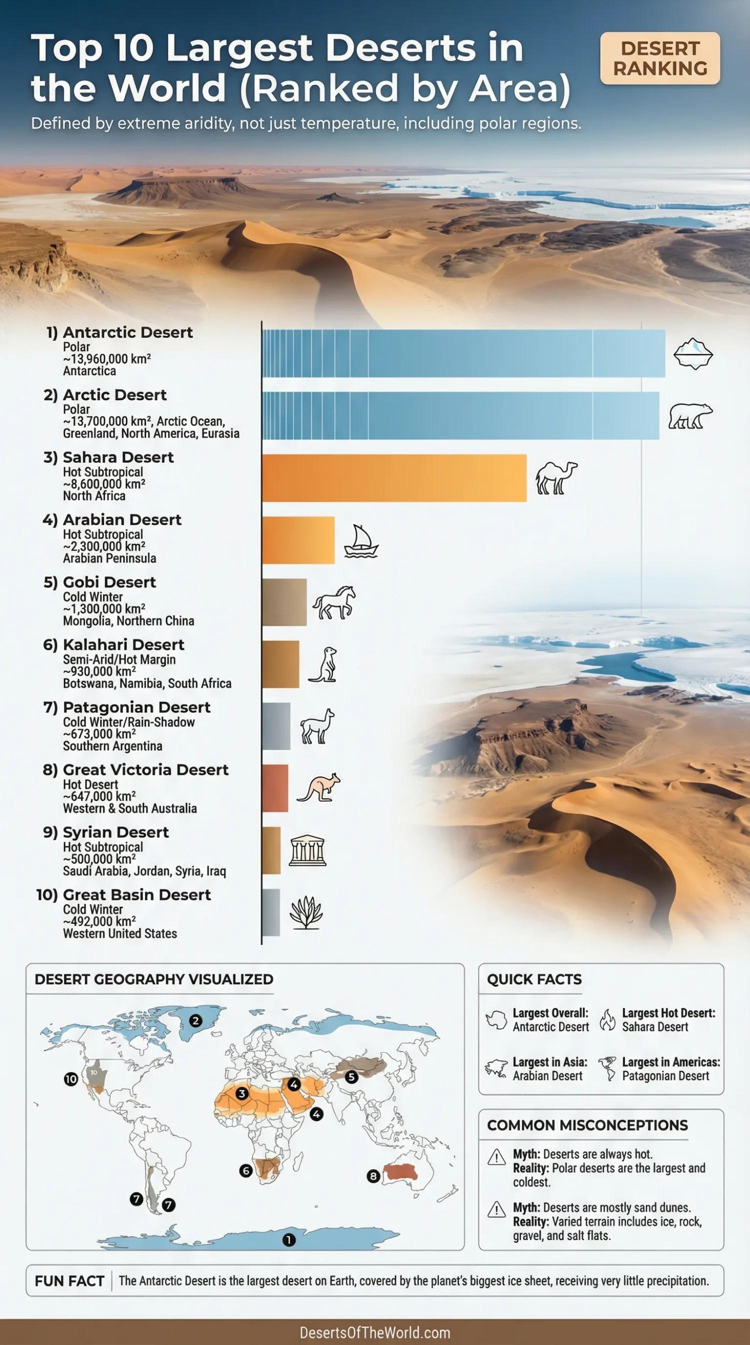
| Rank | Desert | Type | Approximate Area (km²) | Approximate Area (sq mi) | Main Region |
|---|---|---|---|---|---|
| 1 | Antarctic Desert | Polar | 13,960,000 | 5,390,000 | Antarctica |
| 2 | Arctic Desert | Polar | 13,700,000 | 5,300,000 | Arctic Ocean, Greenland, Northern North America, Northern Eurasia |
| 3 | Sahara Desert | Hot Subtropical | 8,600,000 | 3,320,000 | North Africa |
| 4 | Arabian Desert | Hot Subtropical | 2,300,000 | 900,000 | Arabian Peninsula |
| 5 | Gobi Desert | Cold Winter | 1,300,000 | 500,000 | Mongolia and Northern China |
| 6 | Kalahari Desert | Semi-Arid / Hot Desert Margin | 930,000 | 360,000 | Botswana, Namibia, South Africa |
| 7 | Patagonian Desert | Cold Winter / Rain-Shadow | 673,000 | 260,000 | Southern Argentina |
| 8 | Great Victoria Desert | Hot Desert | 647,000 | 250,000 | Western and South Australia |
| 9 | Syrian Desert | Hot Subtropical | 500,000 | 193,000 | Saudi Arabia, Jordan, Syria, Iraq |
| 10 | Great Basin Desert | Cold Winter | 492,000 | 190,000 | Western United States |
How This Ranking Is Counted
This list uses a like-for-like method. It includes polar deserts, because a desert is usually defined as land that receives no more than about 25 centimeters of precipitation a year. It excludes nested sub-deserts when they sit inside a larger desert already on the list. That is why Rub’ al-Khali is discussed below but not ranked separately here; it is the largest part of the Arabian Desert, not a separate desert system at the same scale.
It also avoids umbrella groupings that merge several named deserts into one block. Australia is the best example. Some sources treat the Great Australian Desert as one broad desert region, while others rank Great Victoria, Great Sandy, Simpson, Gibson, and nearby deserts on their own. Area values move for another reason too: many desert edges are transition zones, not knife-sharp borders. The Sahara shifts with climate cycles, and Australian desert boundaries change depending on whether the source uses geomorphology, vegetation, or aridity bands.
Why Lists of the Largest Deserts Often Disagree
Polar Deserts Count
Many readers still expect the Sahara to come first. It does not. Antarctica and the Arctic both qualify as deserts because they receive very little precipitation, even if that precipitation falls as snow. Cold, yes. Desert, still. Once polar deserts are included, the ranking changes immediately.
Not Every Desert Is Mostly Sand
Only a small share of the world’s deserts is dune-covered. The rest includes ice sheets, bare rock, regs, hammadas, gravel plains, dry basins, salt pans, and stony plateaus. So a “largest desert” list is not really a list of the largest sand seas. For sand alone, the best-known giant is the Rub’ al-Khali, the Empty Quarter inside the Arabian Desert.
Boundary Rules Matter
The same desert can appear with different area figures in different references. Sometimes the difference is modest, as with the Sahara. Sometimes it is large, as with Australian deserts, where official national datasets may use narrower mapped boundaries than global reference lists. Read any ranking as an approximate geographic order, not as a frozen scoreboard.
The Largest Deserts, One by One
1) Antarctic Desert
The Antarctic Desert is the largest desert on Earth by a wide margin. It covers almost the entire Antarctic continent and sits beneath the planet’s largest ice sheet. That alone confuses many readers, because ice and desert seem like opposites. They are not. In the dry inland plateau, precipitation is so low that the region fits standard desert thresholds with room to spare.
Its surface is shaped by ice domes, blue-ice fields, crevassed outlet glaciers, and exposed nunataks where mountain peaks rise through the ice. Wind matters here as much as cold. Katabatic winds flow downslope from the high interior and help keep many areas starkly dry. Even in a place covered by ice, the desert signal is clear: little incoming moisture, sparse biological productivity, and long stretches with almost no liquid water at the surface.
2) Arctic Desert
The Arctic Desert spreads across the high north, including Greenland, the Arctic Ocean’s fringes, and the northernmost parts of North America and Eurasia. Its dryness comes from cold air that holds very little moisture. Large parts of the Canadian Arctic Archipelago and the central Arctic fit polar-desert conditions, especially where annual precipitation stays at or below desert levels.
Unlike Antarctica, the Arctic is not one solid landmass. It is a mosaic of sea ice, islands, polar coasts, bare ground, permafrost, and short tundra summers. That patchwork gives it a very different look from the southern polar desert. Still, the core idea is the same: low precipitation, limited plant cover, and landscapes shaped by frost, wind, and seasonal thaw rather than by frequent rain.
3) Sahara Desert
The Sahara is the largest hot desert in the world and the most famous desert by far. It spans most of North Africa and reaches from the Atlantic to the Red Sea. People often imagine it as one endless field of sand, yet the Sahara is more varied than that. Ergs, or sand seas, are only one part of it. Much of the desert is made of regs, hammadas, rocky uplands, chotts, dry basins, and oasis depressions.
Its size shifts over time, which helps explain why one source may give a slightly higher number than another. The desert edge fades into the Sahel rather than ending in a clean line. Inside that vast dry zone, landforms change again and again: volcanic massifs, wadis, salt flats, gravel plains, and dune fields that can rise hundreds of feet. Broad, dry, and geologically busy.
4) Arabian Desert
The Arabian Desert covers most of the Arabian Peninsula and ranks as the largest desert in Asia. It is not a single uniform sea of sand. Its terrain includes gravel plains, lava fields, escarpments, basins, rocky plateaus, and major dune systems. The desert reaches across Saudi Arabia and extends into Jordan, Iraq, Kuwait, Qatar, the United Arab Emirates, Oman, and Yemen.
Inside this wider desert lies the Rub’ al-Khali, or Empty Quarter, the largest continuous sand area within the system. That distinction matters. Many rankings blur the Arabian Desert and the Empty Quarter together, which can make the global order look messy. Kept at the same scale, the Arabian Desert stays in fourth place, while Rub’ al-Khali is better understood as its biggest internal sand sea.
5) Gobi Desert
The Gobi stretches across Mongolia and northern China and is the biggest cold-winter desert in Asia after the polar regions if those are excluded. It is famous for temperature swings, dry air, and a surface that is often more rock and hard-packed ground than soft dune sand. In other words, it looks nothing like the postcard version of a desert.
The Gobi owes much of its dryness to rain shadow effects linked to major uplands and mountain systems in Central and East Asia. That setup blocks moisture before it can spread deep into the basinlands beyond. The result is a desert of open plains, stony surfaces, isolated ranges, and wide skies, with winters cold enough to remind visitors that aridity does not need heat to be severe.
6) Kalahari Desert
The Kalahari covers much of Botswana and reaches into Namibia and South Africa. In many references it ranks as the sixth-largest desert on Earth, though it is often described as a semi-desert because parts of it receive more summer rainfall than a classic hyper-arid desert. Even so, its southwestern half clearly meets desert conditions when evaporation is set against rainfall.
This is a sandy basin more than a bare sand sea. Long fossil dunes, pans, dry valleys, scrub, and grassland dominate the landscape. That plant cover is one reason the Kalahari feels different from the Sahara or Arabian Desert. It is dry, but not empty. After good rains, parts of the region green up fast, which can surprise anyone who expects a desert to remain uniformly barren all year.
7) Patagonian Desert
The Patagonian Desert, often called the Patagonian Steppe, is the largest desert region in the Americas. It occupies a broad belt of southern Argentina east of the Andes. The Andes do much of the work here: they block moist Pacific air, leaving Patagonia in a long rain-shadow zone with strong winds, limited rainfall, and wide semiarid plateaus.
Its look is plainspoken and open. Shrub steppe, gravel surfaces, low mesas, dry valleys, and cold horizons define much of the region. Snow can fall, winters can bite, and the wind is often the first feature people notice. Not a dune desert, then. A dry plateau desert built as much by topography and exposure as by heat.
8) Great Victoria Desert
Great Victoria is usually placed among the ten largest deserts in global reference lists and is widely described as Australia’s largest individual desert. It extends across Western Australia and South Australia and is known for parallel dune fields, gibber plains, salt lakes, spinifex grass, and broad dry expanses that can look sparse from a distance and subtly patterned up close.
This is also where ranking methods become tricky. Some global sources place Great Victoria at about 647,000 square kilometers, while Australian government mapping uses a narrower figure for the named mainland desert itself. So its exact position can slide depending on the dataset. The wider point holds: Australia’s dry interior is made of several linked desert regions, and Great Victoria is one of the biggest and best known among them.
9) Syrian Desert
The Syrian Desert spreads across parts of Saudi Arabia, Jordan, Syria, and Iraq. It is less famous than the Sahara or Gobi, yet in many area-based rankings it sits near the bottom of the global top ten. It is a dry, open region of gravel plains, rocky plateaus, lava fields, and wadis rather than a dune-heavy desert in the popular sense.
Average rainfall is very low, often below desert thresholds across large tracts, and the land merges southward into the Arabian Desert. That merging edge is one reason some lists handle it differently. Treated as its own named desert region, though, the Syrian Desert belongs in the conversation. It shows another side of desert geography: broad stony surfaces, sparse vegetation, and long distances with very little surface water.
10) Great Basin Desert
The Great Basin Desert covers much of Nevada and extends into Utah, California, Idaho, and Oregon. It is the largest desert in the United States and the country’s only major cold desert. Much of its precipitation arrives as winter snow, which sets it apart from the hotter North American deserts farther south.
Its form comes from Basin and Range topography: alternating mountain blocks and wide valleys, with internal drainage that leaves water trapped in basins rather than flowing to the sea. Sagebrush dominates many lower slopes and valley floors. Salt flats, playas, alluvial fans, and fault-bounded ranges give the Great Basin a layered, basin-after-basin structure that feels very different from a classic dune field.
Largest Hot, Cold, and Sand Deserts
- Largest Desert Overall: Antarctic Desert
- Largest Hot Desert: Sahara Desert
- Largest Desert in Asia: Arabian Desert
- Largest Desert in the Americas: Patagonian Desert
- Largest Continuous Sand Area Inside a Desert System: Rub’ al-Khali within the Arabian Desert
- Largest Desert in the United States: Great Basin Desert
Shared Traits Across the Planet’s Biggest Deserts
- Low precipitation is the common rule. Heat is optional, which is why polar deserts top the list.
- Dunes are only one surface type. Ice, gravel, rock, salt crust, and hardpan matter just as much.
- Mountains help make deserts. The Andes shape Patagonia, the Sierra Nevada helps create the Great Basin, and large uplands help dry the Gobi.
- Desert edges are often transition zones. The Sahel near the Sahara and steppe margins near Central Asian deserts show how gradual those boundaries can be.
- Water appears in pulses. Oases, seasonal pans, ephemeral streams, and short wet periods often control where life clusters.
Sources
- Britannica: World’s Largest Deserts (overall ranking and area benchmarks)
- NASA Science: Biome — Desert (desert definition by annual precipitation)
- National Geographic Education: Desert (desert types, aridity, and why not all deserts are sandy)
- British Antarctic Survey: Antarctic Factsheet & Geographical Statistics (Antarctica as a desert and polar climate context)
- NOAA Arctic Report Card — Precipitation (polar-desert conditions across much of the Arctic)
- Geoscience Australia: Areas of Australian and Territory Deserts (official Australian desert area figures and boundary note)
- U.S. National Park Service: Deserts (Great Basin as a cold desert and rain-shadow example)
- Britannica: Sahara (Sahara size, landforms, and shifting margins)
- Britannica: Arabian Desert (Arabian Desert scale and regional setting)
- Britannica: Kalahari Desert (Kalahari area and climate classification)
- Britannica: Patagonia (Patagonian desert region and extent)
- Britannica: Great Victoria Desert (Great Victoria in global desert references)
- Britannica: Syrian Desert (Syrian Desert extent and rainfall)
- Britannica: Great Basin (Great Basin area and regional setting)