
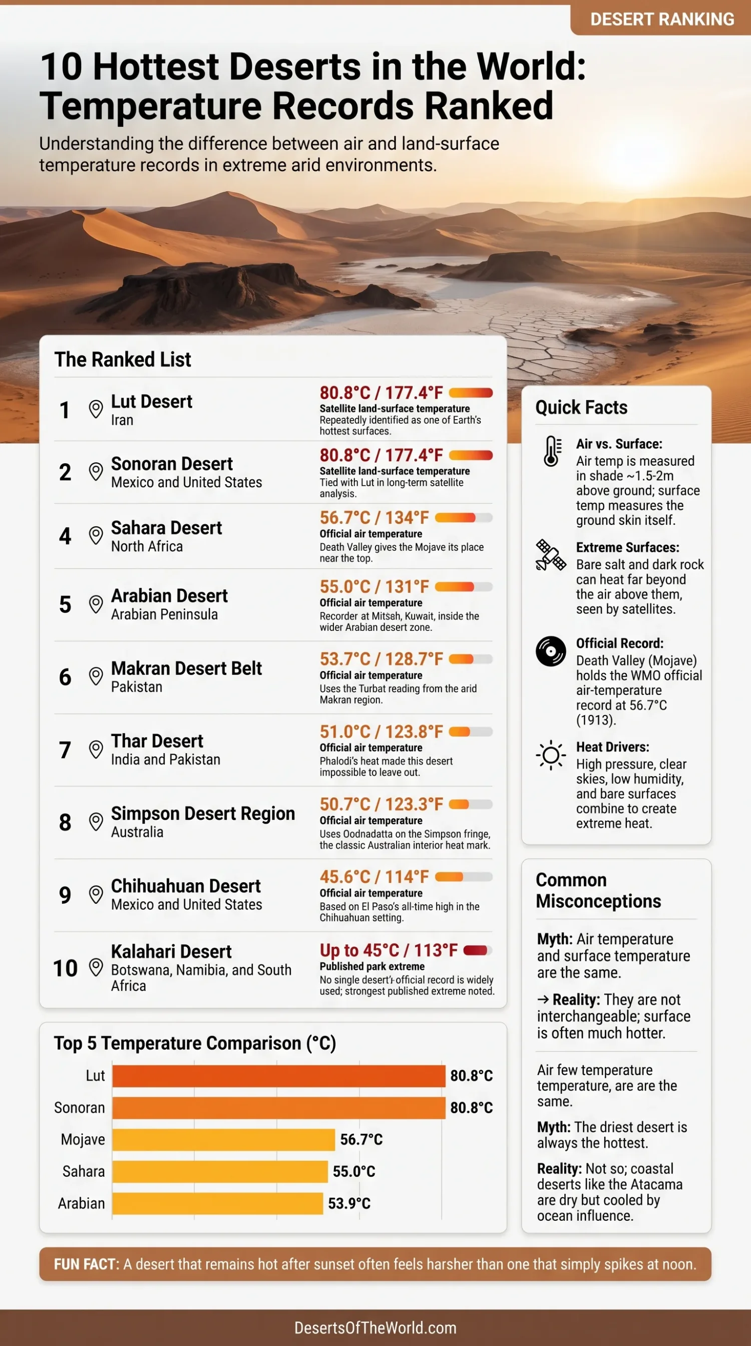
 Heat records in deserts look simple until the numbers are unpacked. Some are standard air temperatures, measured in sheltered conditions a little above the ground. Others are land-surface temperatures, taken by satellite from the skin of the desert itself. Bare salt, dark rock, and wind-polished gravel can heat far beyond the air above them. Because these measurements are not directly comparable, they are presented below in two separate tables rather than combined into one overall ranking.
Highest Recorded Land-Surface Temperatures
| Rank | Desert | Region | Peak Reading | Measurement Type | Note |
|---|---|---|---|---|---|
| 1 (tie) | Lut Desert | Iran | 80.8°C / 177.4°F | Satellite land-surface temperature | Shares the highest reported value in the cited long-term satellite analysis |
| 1 (tie) | Sonoran Desert | Mexico and the United States | 80.8°C / 177.4°F | Satellite land-surface temperature | Matches the Lut Desert in the same long-term satellite analysis |
Lut and Sonoran share first place because the reported peak value is identical. These readings describe the temperature of the ground surface, not the temperature of the surrounding air.
Highest Official Air Temperatures in Desert Regions
| Rank | Desert Region | Country or Region | Peak Air Temperature | Record Location | Note |
|---|---|---|---|---|---|
| 1 | Mojave Desert | United States | 56.7°C / 134°F | Furnace Creek, Death Valley | Official air-temperature record associated with the Mojave Desert region |
| 2 | Sahara Desert | North Africa | 55.0°C / 131°F | Kebili, Tunisia | Officially listed air-temperature reading from the wider Sahara region |
| 3 | Arabian Desert | Arabian Peninsula | 53.9°C / 129.0°F | Mitribah, Kuwait | Official air-temperature record from the Arabian desert zone |
| 4 | Makran Desert Belt | Pakistan | 53.7°C / 128.7°F | Turbat, Pakistan | Official air-temperature reading from the arid Makran region |
| 5 | Sonoran Desert | Mexico and the United States | 51.1°C / 124°F | Yuma, Arizona | Official station reading from the lower Sonoran Desert region |
| 6 | Thar Desert | India and Pakistan | 51.0°C / 123.8°F | Phalodi, India | Official air-temperature record from western Rajasthan |
| 7 | Simpson Desert Region | Australia | 50.7°C / 123.3°F | Oodnadatta, Australia | Official Australian record from the wider arid interior near the Simpson Desert |
| 8 | Chihuahuan Desert | Mexico and the United States | 45.6°C / 114°F | El Paso, Texas | Official station record from the Chihuahuan Desert setting |
The Kalahari is discussed separately because the cited value of up to 45°C comes from published park information rather than a single clearly identified official desert-region record.
Why Desert Heat Records Need Careful Reading
Many short articles treat air temperature and surface temperature as if they were the same number. They are not. Air temperature is the standard used for official weather records. It is measured in shade, with a proper shield, usually 1.5 to 2 metres above the ground. Surface temperature measures the ground itself. On a salt pan, dark lava field, or stony desert pavement, that skin can run far hotter than the air above it.
That difference is why the records are separated here. A person standing in Death Valley experiences the air. A satellite staring at Dasht-e Lut sees the baked surface. Both measurements are real, but they answer different questions and cannot be combined into one scientifically consistent ranking.
- Official air records carry the most weight in meteorology.
- Land-surface records show how brutally hot the desert ground itself can become.
- Some desert regions lack a neat desert-wide official record, so clearly identified station readings or published regional extremes must be described with care.
Lut Desert, Iran
The Lut Desert, or Dasht-e Lut, shares the highest recorded land-surface temperature in this comparison. Satellite studies found temperatures reaching 80.8°C. That is not air temperature. It is the land skin itself, heated under fierce sun on one of the driest, sparsest, most heat-absorbing landscapes on Earth.
Why does Lut get there? Several traits stack the deck:
- Very low cloud cover
- Almost no vegetation
- Dark volcanic and rocky surfaces that soak up solar energy
- Dry air that limits evaporative cooling
- Broad bare ground with little shade anywhere
This is also why Lut appears again and again in satellite work, not as a one-off curiosity but as a repeat offender. It is not merely hot on a bad day. It is built for heat.
Sonoran Desert, Mexico and the United States
The Sonoran Desert surprises people who expect the Sahara to dominate everything. In long-run satellite analysis, the Sonoran reached the same 80.8°C land-surface temperature as Lut, so the two deserts share first place in the surface-temperature table. That says something important about this desert: it combines brutal sunshine with very dry lowlands, sparse cover, and broad, exposed surfaces that turn the ground into a griddle.
The hottest part lies near the lower Colorado River. Summer air temperatures above 49°C are part of the desert’s normal identity, and nearby official stations back that up. Yuma has hit 51.1°C (124°F), which also gives the Sonoran a separate place in the official air-temperature table.
It is also a useful reminder that a desert does not need to be the biggest to be one of the hottest. Size matters less than the combination of latitude, dryness, cloudlessness, bare soil, and low-elevation basins.
Mojave Desert, United States
The Mojave Desert leads the official air-temperature table through Death Valley. The official World Meteorological Organization air-temperature record still stands at 56.7°C (134°F), recorded at Furnace Creek in July 1913. Whatever surface-based numbers satellites may find elsewhere, this is still the famous benchmark in the language of official air temperature.
Death Valley works like a heat trap. Parts of the basin lie below sea level. Mountain walls restrict airflow. The sky is usually clear. Humidity stays low. Dry ground heats fast, and the air above it can stay fierce well into the evening. That last part matters more than many lists admit: a desert that remains hot after sunset feels harsher than one that simply spikes at noon.
Even recent preliminary readings near 54.4°C show that the Mojave is no museum piece living on one old number. It is still fully capable of extreme air heat.
Sahara Desert, North Africa
The Sahara is the largest hot desert on Earth, and it regularly produces the kind of daytime heat most people picture when they hear the word desert. The strongest officially listed air-temperature figure commonly tied to this wider desert belt is 55.0°C (131°F) at Kebili, Tunisia.
Yet the Sahara is more than a single number. Its scale is part of the story. With vast bare surfaces, low rainfall, powerful subtropical high-pressure influence, and long stretches far from maritime moderation, it creates huge belts of summer heat. In many areas, daytime temperatures above 45°C are not unusual in the hottest season.
Another point worth keeping straight: the Sahara is not uniformly sandy. Much of it is rock, gravel plain, stony plateau, salt flat, and mountain mass. Those surfaces matter. Rock and gravel fields can heat the lower air brutally, and they help explain why the Sahara stays among the world’s heat giants even when internet articles reduce it to dunes alone.
Arabian Desert, Arabian Peninsula
The Arabian Desert has an official WMO-listed reading of 53.9°C (129.0°F) from Mitribah, Kuwait. Dry air, broad open plains, sparse vegetation, and a long summer season all work together here. Add flat exposed ground and relentless sunshine, and the result is a desert that holds heat with very little mercy.
The Arabian Peninsula also shows how persistence matters. It is not only about the single highest value. These landscapes can stay extremely hot for long runs, with high overnight temperatures that prevent much cooling. That makes the Arabian Desert one of the hardest heat environments for both people and infrastructure.
On a map, it is tempting to think of the Arabian Desert as one unbroken sand sea. In reality, it includes gravel plains, rocky sectors, and immense dune systems such as the Rubʿ al-Khali. Different surfaces, same outcome: fierce summer heat.
Makran Desert Belt, Pakistan
The Makran region is less famous in popular discussions of desert heat, though it should not be. WMO’s evaluated Asian record list includes 53.7°C (128.7°F) at Turbat, placing this arid belt firmly among the most extreme official air-temperature records associated with desert regions.
Makran is not usually the first desert name that comes to mind, which is exactly why it deserves more attention. It is dry, sparsely watered, and shaped by harsh continental heat even with the Arabian Sea nearby. Turbat’s temperature record shows that lesser-known desert regions can rival the famous headline deserts on raw heat.
This is one of those cases where a comparison improves when it moves beyond the usual names. Not every desert with world-class heat has the brand recognition of the Sahara or Death Valley.
Thar Desert, India and Pakistan
The Thar Desert sits across northwestern India and southeastern Pakistan. Its standout official air-temperature mark is 51.0°C (123.8°F), recorded at Phalodi in Rajasthan. That number pushed the Thar into a different class in the public imagination, though the desert had long been known for punishing pre-monsoon heat.
The Thar’s heat has a slightly different rhythm from that of some western deserts. The hottest stretch often builds before the summer monsoon arrives. Dry air, dusty skies, strong insolation, and sparse vegetation all play a part. So does surface dryness after long rain-poor spells.
And unlike the emptier image many people attach to deserts, the Thar is closely tied to towns, farms, transport routes, and long-settled human landscapes. That makes its heat not just a physical fact but a daily lived reality across a broad inhabited region.
Simpson Desert Region, Australia
Australia has no shortage of harsh desert country, but the classic interior heat mark still belongs to 50.7°C (123.3°F) at Oodnadatta. The station lies southwest of the Simpson Desert, so the fairest way to frame it is as a Simpson Desert region reading rather than a clean centre-of-dunes measurement. Even so, it captures the thermal character of Australia’s arid interior very well.
Why does inland Australia heat so well?
- Great distance from cooling ocean influence
- Clear skies for much of the hot season
- Low humidity
- Open, barren terrain with limited shade
- Strong summer sun over the continental interior
The result is a broad heat belt rather than a single isolated furnace. The Simpson, Great Victoria, Sturt Stony, and surrounding inland deserts all belong to that story.
Chihuahuan Desert, Mexico and the United States
The Chihuahuan Desert does not challenge Lut or Death Valley for the global crown, yet it remains one of the hottest major deserts in North America. El Paso’s all-time high of 45.6°C (114°F) is the anchor used here.
What makes the Chihuahuan different is its mix of altitude and heat. It is not as low-lying as the hottest parts of the Sonoran or Mojave. That tends to cap the very highest peaks. Still, the desert produces long summer runs of hard dry heat, strong solar loading, and very hot afternoons across basins and valley floors.
It is also a good example of why desert heat comparisons should not be built on one stereotype. Some deserts are hottest because they are below sea level. Others because of dark surfaces. Others because their dry continental air and open basins let the sun do its work day after day. The Chihuahuan belongs to that last group.
Kalahari Desert, Southern Africa
The Kalahari is included as additional desert-climate context rather than as part of the official air-temperature ranking. In the southern Kalahari, published park material notes extremes up to 45°C (113°F).
This is also where it helps to be precise. The Kalahari does not have one universally cited desert-wide official high like Death Valley or Kebili. So it is better to state the best documented published extreme than to pretend there is a single settled number for the entire desert system.
The Kalahari’s heat is shaped by dry air, open sandy landscapes, low cloud, and large day-night temperature swings. Parts of it are semi-arid rather than hyper-arid, which is why it can support more vegetation and wildlife than many harsher deserts. Even so, when summer settles in, the heat can be relentless.
What Makes the Hottest Deserts Different From Merely Dry Deserts
One of the easiest mistakes is to assume the driest desert must also be the hottest. Not so. The Atacama is famously dry, yet cool ocean influence and elevation keep it from producing the same extreme heat records. The Namib is another example. Coastal fog and the cold Benguela Current moderate temperatures along large stretches of the desert.
The deserts that produce the most extreme heat records usually share a tighter set of traits:
- Subtropical high-pressure control
- Very clear skies
- Low humidity
- Bare, dark, or rocky surfaces
- Limited vegetation and little evaporative cooling
- Interior basins or lowlands that trap heat
Put those together, and the ground can become ferociously hot. The air follows. In some places, it stays hot after sunset too. That is when a desert stops being a dry landscape and starts behaving like a heat engine.
Why Surface and Air Records Produce Different Leaders
The two tables answer different questions. The Lut and Sonoran deserts share the highest recorded land-surface temperature in the cited satellite analysis. The Mojave Desert leads the official air-temperature table through the Death Valley record.
- Lut and Sonoran share first place for recorded land-surface temperature.
- Mojave ranks first for official air temperature in a desert region.
- The two measurements must not be combined into one numerical ranking.
- A desert can appear in both tables when reliable records exist for both measurement types.
There is no single scientifically consistent answer to the question “Which desert is hottest?” The answer depends on whether the comparison concerns the temperature of the ground surface or standardized air temperature.
Sources
- World Meteorological Organization: Records of Weather and Climate Extremes Table (official world, hemispheric, and regional temperature records)
- NASA Earth Observatory: The Hottest Spot on Earth (satellite land-surface temperature findings for the Lut Desert)
- NASA Earth Observatory: Iran’s Lut Desert (newer context on Lut and its place in long-term MODIS analysis)
- Bulletin of the American Meteorological Society: Global Patterns of Hottest, Coldest, and Extreme Diurnal Land Surface Temperatures (scientific paper identifying Lut and the Sonoran among the hottest land surfaces)
- NOAA / National Weather Service: Warmest and Coolest Temperatures Ever Recorded at Death Valley (Death Valley temperature record summary)
- NOAA / National Weather Service: Historical Extreme Temperatures in Phoenix, Yuma, and El Centro (official Sonoran-region air-temperature extremes)
- NOAA / National Weather Service El Paso: Extreme Weather Records (official Chihuahuan-region temperature record)
- Australian Bureau of Meteorology: Climate Extremes (official Australian temperature records, including Oodnadatta)
- India Meteorological Department: Annual Report 2016 (Phalodi 51.0°C record in western Rajasthan)
- SANParks: Kgalagadi Transfrontier Park Major Features (published temperature extremes for the southern Kalahari)
- Encyclopaedia Britannica: Sahara (desert scale, geography, and climate context)
- Encyclopaedia Britannica: Sonoran Desert (climate context for the lower Colorado sector)
- Encyclopaedia Britannica: Makran (geographic context for the arid Makran region)
- Encyclopaedia Britannica: Phalodi (location of Phalodi within the Thar Desert setting)
- Encyclopaedia Britannica: Oodnadatta (location of Oodnadatta relative to the Simpson Desert)