The Mojave Desert and the Great Basin Desert sit close enough on the map that people often lump them together. That misses the real story. Both grow in the rain shadow east of major western mountain chains, yet they do not behave the same way at all. One is better known for creosote bush, Joshua tree, blackbrush, hot basins, and very low rainfall. The other is shaped by sagebrush, shadscale, higher valley floors, snowy winters, and closed drainage basins.
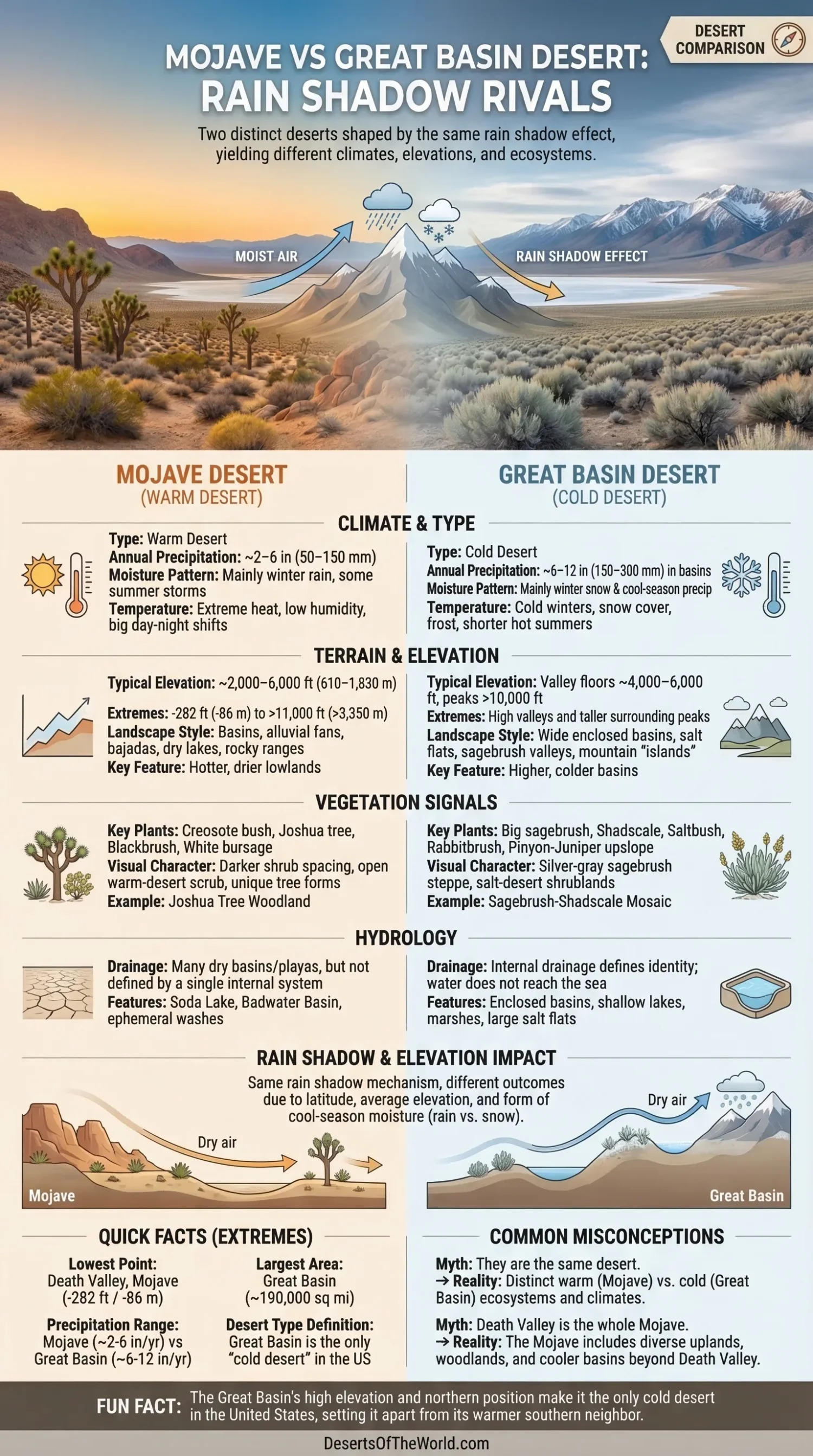
They are neighbors, yes. Twins, no. The Mojave is usually classed as a warm desert. The Great Basin is the only cold desert in the United States. That single contrast changes almost everything: plant cover, winter moisture, soil behavior, and even how the land feels under your feet at sunrise.
Core Differences Between the Two Deserts
| Feature | Mojave Desert | Great Basin Desert |
|---|---|---|
| Approximate Area | More than 25,000 sq mi (about 65,000 sq km) | About 190,000 sq mi (about 492,000 sq km, depending on boundary used) |
| Desert Type | Warm desert | Cold desert |
| Typical Annual Precipitation | About 2–6 in (50–150 mm) | About 6–12 in (150–300 mm) in many basins |
| Moisture Pattern | Mainly winter rain, with some summer storm influence near southern and eastern margins | Mainly winter snow and cool-season precipitation |
| Typical Elevation | Often around 2,000–6,000 ft (610–1,830 m), though extremes are much wider | Many valley floors around 4,000–6,000 ft (1,220–1,830 m), with many peaks above 10,000 ft |
| Vegetation Signals | Creosote bush, Joshua tree, blackbrush, white bursage | Big sagebrush, shadscale, saltbush, rabbitbrush, pinyon-juniper upslope |
| Landscape Style | Basins, alluvial fans, bajadas, dry lakes, salt flats, rocky ranges | Wide enclosed basins, salt flats, sagebrush valleys, mountain “islands” |
| Hydrology | Many dry basins and playas, but not defined mainly by one giant internal drainage system | Defined by internal drainage; water does not reach the sea |
| Most Distinctive Plain-English Difference | Hotter, drier lowlands with creosote and Joshua tree | Higher, colder basins with sagebrush and winter snow |
Why These Two Deserts Get Compared So Often
The comparison makes sense because both deserts belong to the Basin and Range country of the western United States. In both places, long mountain lines rise above dry basins, and broad alluvial fans spill gravel and sand from canyon mouths onto valley floors. Playas, salt flats, bajadas, and fault-block ranges appear in both landscapes. To a casual eye, they can look close cousins.
Still, the land gives away the difference pretty fast. Mojave country usually carries a warmer look: more creosote, more open blackbrush, more yucca, more low hot basins. Great Basin country reads cooler and higher: more sagebrush, more salt-desert shrub, more winter snow, more valley floors that start high before the mountains even begin.
How the Same Rain Shadow Creates Two Different Deserts
Mountain Barriers Strip Moisture From Pacific Storms
Both deserts owe a lot to orographic rain shadow. Moist air moves inland from the Pacific, climbs the Sierra Nevada and, farther north, the Cascade system, cools, and drops much of its moisture on the western slopes. By the time that air descends east of the mountains, it is drier and warmer. The result is arid land on the lee side.
Same rain shadow. Different desert. That is the part people often skip. The position of each desert, its average elevation, and the form of its cool-season moisture change the outcome. The Great Basin sits farther north overall and much of it sits higher. Snow matters there. Freeze-thaw cycles matter there. The Mojave, by contrast, includes much lower and warmer basins, so the dry air arrives in a hotter setting.
Elevation Decides More Than Many Readers Expect
The Great Basin Desert is not simply “a drier place north of the Mojave.” It is a higher desert with cold winters, wide daily temperature swings, and many valleys already around 4,000 to 6,000 feet before the surrounding peaks rise another few thousand feet. That is why winter snow, sagebrush cover, and cold-desert soil processes are so common there.
The Mojave Desert is often called a high desert too, and that is true in many sectors. Yet its lowest basins pull the desert downward in a big way. Death Valley reaches 282 feet (86 m) below sea level, while Telescope Peak rises to 11,049 feet (3,368 m). So even inside the Mojave, one landscape can feel furnace-hot and another almost montane. Broad is the range.
Rainfall, Snow, and Temperature
In plain numbers, the Mojave Desert usually receives around 2 to 6 inches of precipitation a year (about 50 to 150 mm). Parts of Death Valley average less than 2 inches (about 5 cm). Winter precipitation does much of the work, though southern and eastern edges can also feel some late-summer storm influence. The rain often arrives in pulses, not a steady patten.
The Great Basin Desert commonly falls in the 6 to 12 inch range (about 150 to 300 mm) across many basins, yet that simple average hides strong vertical contrast. Some valley bottoms receive only around 100 mm a year, while taller ranges can exceed 1,000 mm, much of it as snow. That snow feeds springs, short streams, wet meadows, and cooler mountain belts above the desert floor.
Temperature follows that structure. The Mojave is tied to heat extremes, low humidity, and big day-night shifts. The Great Basin is tied to cold-desert seasonality: hot summer afternoons can still happen, but winter nights can drop hard, snow cover lingers longer, and frost is far less surprising. This is why the Great Basin looks more silver-gray and shrub-steppe in many places, while the Mojave leans toward darker shrub spacing and more open warm-desert scrub.
Landforms, Soils, and Surface Water
Both deserts show the hand of Basin and Range faulting. Crust stretched, blocks tilted, basins sank, and mountain fronts rose. Over long spans of time, runoff cut canyons into the uplands and spread sediment onto piedmonts and valley floors. That is why alluvial fans, bajadas, playas, dry washes, and salt flats recur in both deserts.
The hydrology, though, tilts the comparison toward the Great Basin. Its identity is tied to internal drainage. Water does not flow to the Pacific or the Atlantic. It ends in enclosed basins, shallow lakes, marshes, mud flats, or salt flats, then evaporates or sinks into the ground. That closed-basin behavior explains why saline soils, alkali flats, and broad desert basins are so common there.
The Mojave also has dry lakes and salt pans, of course. Soda Lake, Badwater Basin, and other playa settings make that easy to see. Yet the Mojave is usually read first through heat, sparse shrub cover, rocky fans, basin walls, and warm-desert vegetation, not through one giant endorheic identity in the same way the Great Basin is.
Soil chemistry helps separate them too. In both deserts, salinity, alkalinity, and caliche development can shape what grows where. In the Great Basin, salt-desert shrub communities often occupy low alkaline floors. In the Mojave, creosote bush, bursage, and blackbrush sort themselves out across fan surfaces, gravel pavements, washes, and elevation bands with striking precision.
Creosote and Joshua Tree vs Sagebrush and Shadscale
If you had to separate these deserts by plants alone, the cleanest clue would be this: the Mojave Desert belongs to the world of creosote bush (Larrea tridentata), Joshua tree (Yucca brevifolia), blackbrush (Coleogyne ramosissima), and white bursage (Ambrosia dumosa). The Great Basin Desert belongs mainly to big sagebrush (Artemisia tridentata), shadscale (Atriplex confertifolia), rabbitbrush, saltbush, and other cold-desert shrubs.
Joshua tree is especially useful because it tells readers that the landscape is not just dry but Mojave-dry in the right elevation band. It does not mark the whole Mojave, and it does not blanket every slope. Still, it is one of the clearest botanical signals in North American desert geography. No such tree-form marker stands over the Great Basin in the same way. There, the broad visual field is often a sagebrush-shadscale mosaic.
Higher up, both deserts gain woodland belts. Pinyon-juniper can appear in both systems, and that sometimes confuses simple map-based thinking. But the context differs. In the Mojave, pinyon-juniper often sits above blackbrush and Joshua tree zones. In the Great Basin, pinyon-juniper and mountain shrub belts rise above sagebrush valleys and salt-desert floors. Upslope, the Great Basin can even push into aspen, conifer, and bristlecone pine country.
This is one reason many quick comparisons fail. They look only at the valley floor. Yet desert identity often changes by vertical zonation, not just latitude. Go upslope and the story sharpens.
Wildlife Signals Are Different Too
Plant structure shapes animal life. Mojave habitats support species linked to warm-desert scrub, open gravelly ground, and sparse shade. The Mojave desert tortoise, for example, fits that setting well, as do many lizards, kit fox populations, and birds adapted to creosote and blackbrush country. Sparse cover, burrow use, and seasonal timing all reflect a hot, dry environment with limited surface water.
Great Basin habitats lean toward animals tied to sagebrush steppe, salt-desert shrublands, and higher cold-desert valleys. Across the wider region, pronghorn, jackrabbits, sagebrush songbirds, and sage-grouse-linked habitat patterns tell that story better than tortoise and Joshua tree do. Same aridity? Yes, in part. Same ecological setting? Not quite.
The Border Between Them Is Not a Hard Line
Many readers expect a sharp boundary: Mojave on one side, Great Basin on the other. Nature rarely works so neatly. The transition can be gradual, especially where elevation shifts fast and basin floors stack into foothills and uplands. A lower fan may carry creosote and blackbrush, while the next rise begins to show sagebrush, hopsage, or pinyon-juniper. Mixed zones happen. Often, that is where the comparison gets most intresting.
Botanists and land managers often describe this edge through indicator plants more than through one single line on a map. Where creosote bush fades and sagebrush and shadscale take over, the desert character changes with it. That mixed plant patten is one of the best ways to understand the rivalry in the title. Not a border fence. A gradient.
Shared Features That Make Them Look Related
- Both are shaped by rain shadow and Basin and Range topography.
- Both contain playas, dry washes, alluvial fans, and fault-bounded basins.
- Both show large day-night temperature swings.
- Both have sparse vegetation compared with humid regions, but neither is lifeless.
- Both contain strong elevation gradients that change soils, moisture, and plant zones over short distances.
Those similarities are real. They just do not erase the deeper split between a warmer creosote-and-yucca desert and a higher sagebrush-and-snow desert.
One More Difference People Miss: Death Valley Is Not the Whole Mojave
Death Valley dominates how many people imagine the Mojave Desert. Fair enough; it is one of the most striking low-elevation basins on Earth. But using Death Valley as the whole model for the Mojave flattens the desert into a single image of bare heat. The Mojave also includes uplands, Joshua tree woodlands, blackbrush belts, mountain blocks, cooler basins, and broad fans. It is dry, but it is not one-note.
The same simplification happens in reverse with the Great Basin Desert. Many people picture only white salt flats. Yet the desert is much more than alkali ground. Vast sagebrush valleys, shadscale plains, pinyon-juniper slopes, and mountain “islands” are just as central to its identity. Miss those, and you miss the desert itself.
Modern Ecological Pressure Across Both Deserts
One shared issue links the two deserts today: invasive annual grasses and altered fire behavior. In parts of the Great Basin, cheatgrass has helped create a fire cycle that works against sagebrush recovery. In parts of the Mojave, post-fire landscapes can shift toward invasive grasses such as red brome and cheatgrass, which then raise the chance of repeat burns in shrublands that do not bounce back fast. Different plant communities, same basic problem.
Which Desert Feels Harsher?
That depends on what you mean by harsh. For raw heat and very low rainfall, the Mojave usually wins. For cold winters, snow, and long high basins, the Great Basin takes the lead. One burns. One freezes. Both dry the land hard.
So when the two are set side by side, the clearest reading is this: the Mojave and the Great Basin are not just two deserts behind the same mountain wall. They are two different answers to the same western rain-shadow setup. One comes out warmer, lower in many places, and tied to creosote and Joshua tree. The other comes out higher, colder, and tied to sagebrush, shadscale, snow, and enclosed basins.
Sources
- U.S. Geological Survey — Joshua Tree National Park Ecology (Mojave rainfall, elevation range, and ecological setting)
- National Park Service — Deserts, Joshua Tree National Park (Mojave boundaries, elevation, temperature, and rain-shadow setting)
- National Park Service — Weather, Death Valley National Park (Death Valley heat and very low annual rainfall)
- National Park Service — Plants, Death Valley National Park (Mojave–Great Basin elevation spread and plant diversity)
- National Park Service — Deserts, Great Basin National Park (Cold-desert identity, snow-based moisture, and desert definition)
- National Park Service — The Great Basin (Rain shadow, sagebrush-shadscale valleys, and mountain-island structure)
- U.S. Geological Survey — Great Basin Carbonate and Alluvial Aquifer System, Chapter 2 (Great Basin precipitation gradient, hydrology, and rain-shadow mechanics)
- Encyclopaedia Britannica — Mojave Desert (Area, climate, and regional extent)
- Encyclopaedia Britannica — Great Basin (Area, internal drainage, and regional geography)