
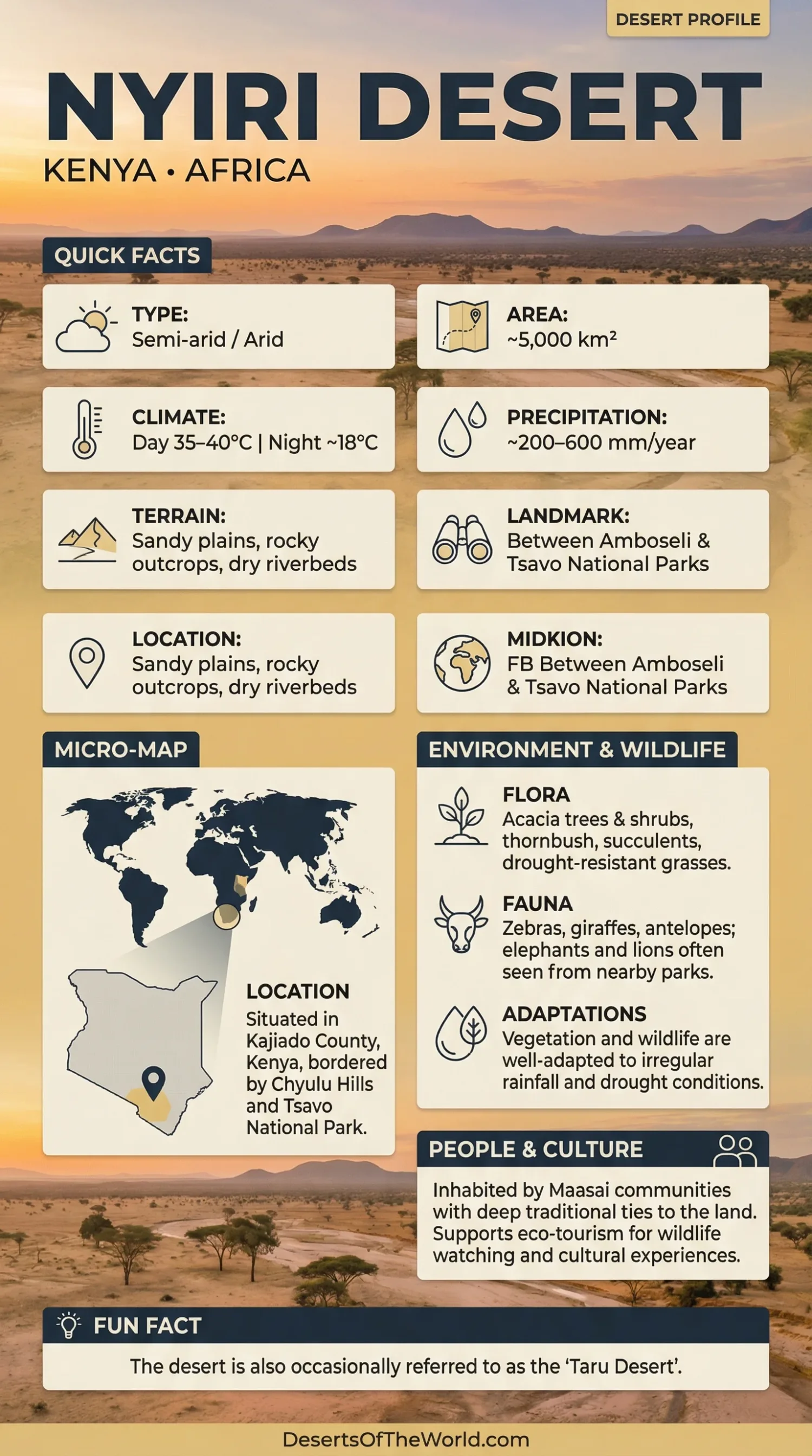
Location & Continent
Continent: Africa
Country: Kenya
Region: Southern Kenya, mainly within the wider Kajiado–Amboseli drylands
Coordinates: Approximately 2°24′S, 37°16′E
Physical Features
Area: No single standardized boundary or area measurement is consistently used for the Nyiri Desert
Landscape: Dry plains, thorn scrub, grassland, rocky outcrops, gravel surfaces, seasonal drainage channels, and locally volcanic soils
Setting: East of Lake Magadi and north of the Kenya–Tanzania border, within the wider landscape connecting Amboseli, Chyulu Hills, and Tsavo
Elevation: Mostly low to moderately elevated plains, with surrounding hills and volcanic uplands rising above them
Climate & Precipitation
Climate: Arid to semi-arid tropical dryland climate
Temperature: Hot conditions dominate the low plains, with daytime temperatures commonly above 30°C during warm periods
Rainfall: Low, variable, and strongly seasonal; the wider Kajiado drylands receive most rainfall during March–May and October–December
Water: Permanent surface water is limited outside springs, wetlands, and groundwater-supported areas associated with the Amboseli system
Ecological Features
Biogeographic Realm: Afrotropical
Environment: Semi-arid savanna, thorn scrub, open grassland, dry bushland, and seasonal wetland margins
Regional Ecosystem: Part of the wider Amboseli–Kilimanjaro–Tsavo dryland landscape
Seasonality: Vegetation and wildlife distribution shift markedly between wet and dry seasons
Flora & Fauna
Flora: Acacia-type thorn woodland, Commiphora scrub, drought-tolerant grasses, euphorbias, baobabs in some sectors, and seasonal herbs following rainfall
Fauna: African bush elephant, giraffe, zebra, wildebeest, eland, gazelles, impala, lion, cheetah, hyena, jackal, and numerous dryland birds
Wildlife Movement: Elephants, zebras, wildebeest, and other large mammals move between Amboseli, surrounding community lands, Chyulu Hills, Tsavo, and the Kilimanjaro ecosystem
Geology & Notable Features
Geology: A mixture of older basement terrain, alluvial and lacustrine sediments, and volcanic material associated with Mount Kilimanjaro and the Chyulu volcanic region
Notable Features: Amboseli basin, dry Lake Amboseli surface, Chyulu Hills, rocky inselbergs, seasonal drainage lines, and wildlife corridors across southern Kajiado
Nyiri Desert
The Nyiri Desert, also known in older sources as the Taru Desert or Nyika, is a semi-arid dryland region in southern Kenya. It lies east of Lake Magadi and extends through country associated with the wider Amboseli and southern Kajiado landscape near the Tanzania border.
The word “desert” can give a misleading impression of continuous bare sand. Much of Nyiri consists instead of dry bushland, thorn scrub, open grassland, gravelly plains, exposed rock, and seasonal drainage channels. Vegetation may become sparse during prolonged dry periods and then respond rapidly when seasonal rains return.
Geography
Nyiri occupies part of the dry country between the southern Kenyan highlands, the eastern Rift Valley, the Amboseli basin, and the Chyulu–Tsavo region.
Published descriptions commonly place it about 80 km east of Lake Magadi and near Kenya’s border with Tanzania. The term has historically been applied rather loosely to a broad dryland belt rather than to a surveyed desert with one universally accepted perimeter.
For that reason, area figures published for Nyiri vary widely. Values ranging from a few hundred to many thousands of square kilometers appear in secondary sources, often without a clear mapped boundary. A single precise area should therefore not be presented as settled geographic data.
The terrain is also more varied than a dune desert. Common surfaces include:
- Dry plains: Open areas carrying grasses and low shrubs after rain.
- Thorn scrub: Woody vegetation dominated by plants adapted to seasonal water shortage.
- Rocky outcrops: Isolated hills and exposed basement rock occur across parts of the landscape.
- Seasonal channels: Temporary runoff follows shallow valleys and drainage lines after rain.
- Volcanic terrain: Eastern and southern sectors grade toward landscapes influenced by Kilimanjaro and the Chyulu volcanic field.
Climate and Rainfall
The Nyiri region has a dry tropical climate marked by irregular rainfall and recurring drought.
Rainfall across southern Kajiado is strongly seasonal. The main wet periods generally occur during the March–May long rains and the October–December short rains. Totals vary sharply across short distances because of elevation, local topography, and proximity to Mount Kilimanjaro and other uplands.
Kajiado County as a whole includes both arid and semi-arid zones. County planning documents record annual rainfall ranging from roughly 300 mm in dry lowlands to more than 1,000 mm in wetter uplands, showing why one rainfall figure cannot describe the entire Nyiri landscape.
Dry-season evaporation is high. Temporary pools and streams disappear quickly, while permanent water becomes concentrated around springs, wetlands, boreholes, and groundwater-fed areas.
Amboseli Basin
The Amboseli basin forms one of the best documented dryland systems associated with the Nyiri region.
The basin contains the floor of an ancient Pleistocene lake. Fine lake sediments produced broad, level surfaces, including the modern dry bed of Lake Amboseli. Saline and alkaline soils occur across much of the basin because it remains a closed drainage system.
Although rainfall is low, Amboseli contains permanent and semi-permanent wetlands. Much of this water originates as precipitation on Mount Kilimanjaro, infiltrates porous volcanic rocks, and later reappears through springs and groundwater discharge farther north.
This creates a sharp ecological difference between dry plains and nearby swamps. During dry periods, these water sources concentrate wildlife from a much larger surrounding area.
Vegetation
Vegetation changes according to soil, groundwater, grazing pressure, and seasonal rainfall.
Dry plains support thorny shrubs, drought-tolerant grasses, Commiphora, acacia-type woodland, and other plants adapted to long rainless periods. Euphorbias occur in parts of the dry bushland, while baobabs become more common toward some eastern and southeastern areas.
After rainfall, annual grasses and herbs can grow rapidly across ground that appeared nearly bare during the preceding dry season.
Around groundwater-supported wetlands, plant communities are different. Reeds, sedges, grasses, and other moisture-dependent species occupy swamps and wetland margins within the Amboseli system.
Wildlife and Seasonal Movement
Large mammals using the Nyiri–Amboseli landscape do not remain in one habitat throughout the year.
During dry periods, animals concentrate around permanent water and remaining pasture. When rain returns, many disperse onto surrounding community rangelands.
Species using the wider landscape include:
- African bush elephant
- Maasai giraffe
- Plains zebra
- Wildebeest
- Eland
- Grant’s and Thomson’s gazelles
- Impala
- Lion, cheetah, leopard, and spotted hyena
The wildlife seen in the region should not be described as confined to a single “Nyiri Desert ecosystem.” Many species move across national parks, community ranches, conservancies, wetlands, and cross-border habitats according to water and forage conditions.
Wildlife Corridors
Movement corridors are a defining feature of the southern Kenya drylands.
Kenya Wildlife Service mapping identifies several routes connecting Amboseli National Park with surrounding rangelands, Chyulu Hills, Tsavo West, and Mount Kilimanjaro in Tanzania.
Among them are:
- Amboseli–Kitenden–Kilimanjaro;
- Amboseli–Kimana–Kuku–Chyulu West;
- Amboseli–Olgulului North–Selengei;
- Amboseli–Olgulului North–Mbirikani.
Elephants, zebras, wildebeest, eland, buffalo, and predators use different parts of these routes.
The corridors explain why areas outside formal park boundaries matter to regional wildlife. A relatively small national park cannot contain all of the land used by mobile herds through both wet and dry seasons.
Maasai Pastoralism
Much of the wider Nyiri and Amboseli landscape is also Maasai pastoral country.
Livestock herding has historically depended on mobility. Cattle, sheep, and goats are moved between grazing areas as rainfall, grass, and water availability change through the year.
This seasonal system uses the same broad rangelands that support migratory wildlife. Livestock and wildlife may therefore depend on overlapping water points, grazing areas, and drought refuges.
The present landscape includes community land, private parcels, conservancies, settlements, agricultural areas, national parks, and other protected land. Land ownership and use are not uniform across Nyiri or Kajiado County.
Land Subdivision and Habitat Change
The main documented pressures around the Amboseli–southern Kajiado landscape are more specific than a general description of “human impact.”
Kenya Wildlife Service identifies land subdivision, settlement growth, agricultural expansion, fencing, overgrazing, water extraction, charcoal production, and loss of wetland or woodland habitat among pressures affecting wildlife movement and rangeland condition.
Subdivision can be particularly important because a continuous grazing area may become divided into smaller fenced or cultivated parcels. That can restrict both pastoral livestock movement and wildlife dispersal.
Water development also has mixed effects. Boreholes, pipelines, irrigation, and permanent water points support settlements and livestock, but changes in water use can alter wetlands and concentrate grazing around limited sources.
Protected Areas and Community Lands
Nyiri is not a single protected desert reserve.
The wider landscape includes Amboseli National Park, nearby community conservancies and rangelands, connections toward Chyulu Hills National Park and Tsavo West National Park, and cross-border movement toward Kilimanjaro in Tanzania.
Amboseli National Park protects the central wetland and lake-basin system but covers only part of the area used seasonally by wildlife. KWS management documents therefore treat surrounding dispersal lands and corridors as part of the functioning Amboseli ecosystem.
This regional approach is more accurate than describing conservation as a set of generic activities confined to the desert itself.
Nyiri, Nyika and Taru
Several names appear in historical and modern descriptions of this dryland.
Nyiri Desert is the common English geographic name. Nyika has also been used for dry bush country or wilderness, while Taru Desert or Taru Plain appears in older descriptions of the dry belt inland from the Kenyan coast.
These terms have not always referred to identical mapped boundaries. Treating them as exact modern administrative units can therefore create conflicting area, location, and climate figures.
Conclusion
The Nyiri Desert is a semi-arid southern Kenyan landscape of dry plains, thorn scrub, grassland, rocky ground, seasonal drainage, and localized volcanic terrain. Its boundaries are loosely defined, so published area estimates should be treated cautiously.
The Amboseli basin forms one of its best documented ecological settings. Groundwater from the Kilimanjaro system sustains wetlands within otherwise dry country, while elephants, zebras, wildebeest, giraffes, predators, livestock, and pastoral communities use a much larger network of rangelands. Land subdivision, fencing, agriculture, and changing water use now affect several of the movement routes linking Amboseli with Chyulu, Tsavo, and Kilimanjaro.
References
Encyclopaedia Britannica – Nyiri Desert
UNESCO World Heritage Centre – Amboseli National Park
Kenya Wildlife Service – Amboseli National Park Management Plan 2020–2030
Kenya Wildlife Service – Wildlife Migratory Corridors and Dispersal Areas
County Government of Kajiado – County Integrated Development Plan 2023–2027