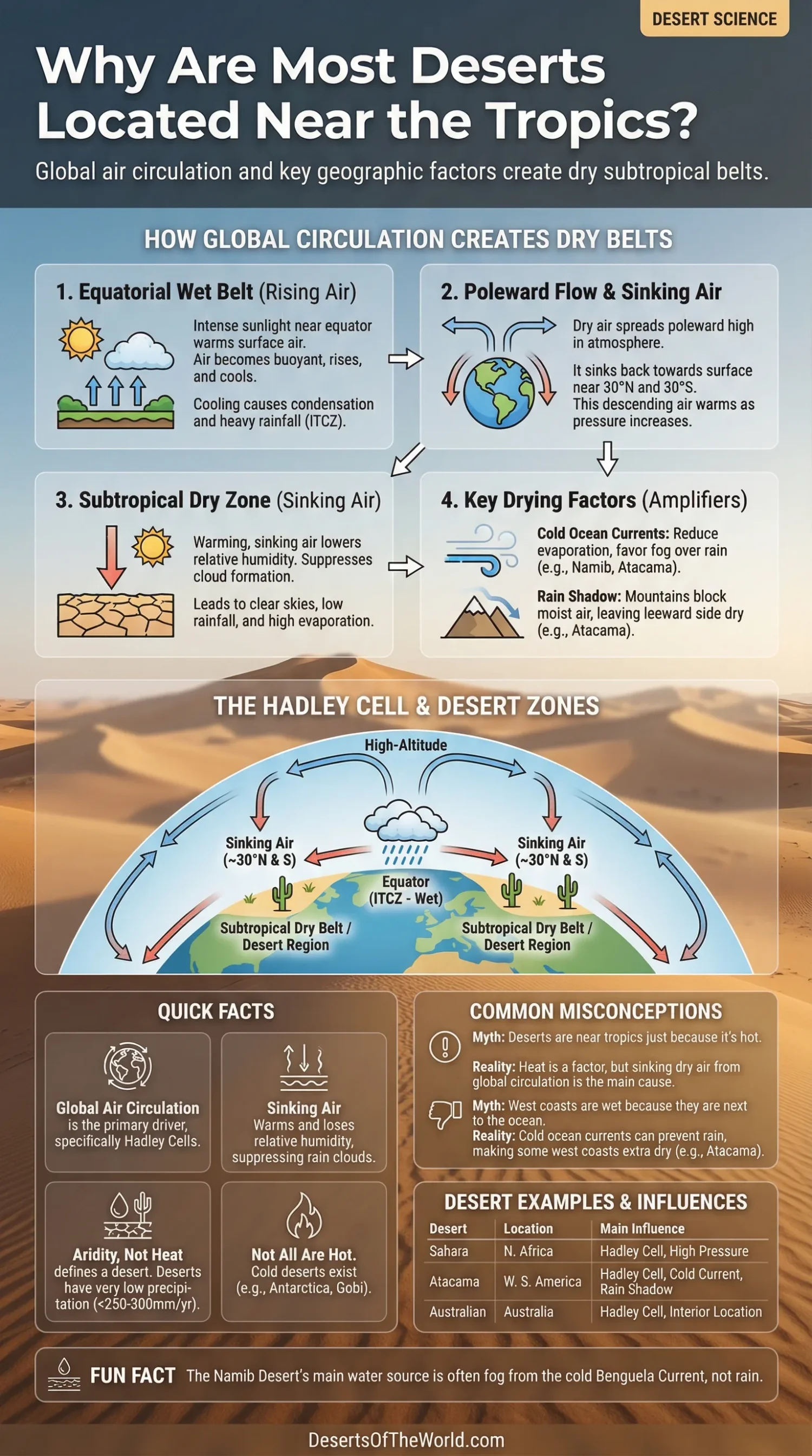
Most deserts are located near the tropics because Earth’s atmosphere creates dry belts on both sides of the equator. Warm, moisture-rich air rises in the equatorial rain belt, cools, and releases much of its water there. Farther poleward, that air sinks again around 20° to 35° north and south, warms as it compresses, and becomes much less likely to form rain clouds. That is why the broad subtropical dry zone lines up so well with the Sahara, Arabian Desert, Namib, Atacama, Kalahari, and much of inland Australia.
| Drying Factor | How It Works | Where It Shows Up |
|---|---|---|
| Hadley Cell Sinking Air | Air rises near the equator, loses moisture, then sinks near 30° latitude and suppresses rainfall. | Sahara, Arabian Desert, Australian Deserts |
| Subtropical High Pressure | Persistent high pressure favors clear skies, dry air, and long rain-free periods. | North Africa, Southwest Asia, Southern Africa |
| Cold Ocean Currents | Cold water reduces evaporation and often creates fog or a temperature inversion instead of rain. | Namib, Atacama |
| Rain Shadow | Mountains force moist air upward, where it rains out; the leeward side stays dry. | Atacama, Interior Basins, Some Asian Deserts |
| Distance From Moisture Sources | Interior regions lie far from ocean moisture and often miss reliable rainfall. | Australian Interior, Parts of Arabia |
Why the Dry Belt Sits Near the Tropics
The phrase “near the tropics” is only partly right. The wettest belt on Earth sits close to the equator, not in the desert zone. Most hot deserts sit just outside that wet belt, usually in the subtropics near the Tropics of Cancer and Capricorn and often a bit beyond them. So the main reason is not simply heat. It is global air circulation.
Near the equator, sunlight is intense through the year. Surface air heats up, becomes buoyant, and rises. As it rises, it cools. Cooling causes water vapor to condense into clouds, and rain falls out. This is the Intertropical Convergence Zone, often shortened to ITCZ. It helps feed tropical rainforests and other wet low-latitude regions.
Once that air has risen and lost much of its moisture, it spreads poleward high in the atmosphere. Later, it sinks back toward the surface. Down it comes near 30° north and 30° south. That sinking branch is the heart of the pattern.
How Sinking Air Turns Land Dry
Sinking air warms as pressure increases closer to the ground. Warm air can hold more water vapor than cool air, so its relative humidity drops as it descends. In plain terms, the air becomes farther from saturation. Fewer deep clouds form. Rain becomes harder to produce.
This is why the subtropics are known for broad high-pressure belts. Clear skies are common there. So are long dry spells. Strong sunshine reaches the surface, soils lose moisture, and evaporation stays high where water is available. Wet tropics sit under rising air; dry subtropics sit under sinking air.
This pattern is tied to the Hadley cells, the large overturning air circulations that run from the equator into the subtropics. It also explains the old term “horse latitudes,” used for the calmer, drier belts near 30° latitude.
Why Heat Alone Does Not Make a Desert
A desert is defined by aridity, not by heat, not by sand, and not by empty scenery. Many deserts receive very little annual precipitation, often under about 250 to 300 millimeters. Some are rocky. Some are gravel plains. Some are cold. Antarctica is a desert too.
That matters here because it corrects a common mistake: deserts are not near the tropics simply because those places are hot. They are near the tropics because the atmosphere tends to remove the conditions that make steady rainfall possible.
Why West Coasts Near the Tropics Are Often Extra Dry
The Hadley cell explains the latitude pattern, but it does not fully explain why several famous deserts sit on western continental margins. Cold ocean currents finish the job.
Along the west coasts of Africa and South America, the Benguela and Humboldt currents cool the lower atmosphere. Cooler surface air means less evaporation from the ocean. It also favors a temperature inversion, a layer that limits vertical cloud growth. Fog may form. Rain often does not.
The Namib is a good example. It is a coastal desert, yet fog is a regular source of moisture for many plants and animals. The Atacama shows the same logic in another setting. Cold offshore water helps keep the coast dry even when clouds and mist appear.
Why Mountains Matter So Much
Mountains can take an already dry setting and make it drier. When moist air is pushed up a mountain slope, it cools and drops precipitation on the windward side. After crossing the crest, the air descends, warms, and dries further on the leeward side. This is the rain-shadow effect.
The Atacama is one of the clearest cases. It sits in the subtropical dry belt, the cold Humboldt Current helps limit rainfall near the coast, and the Andes block much of the moisture that might otherwise arrive from the east. One process dries the region. Three together make it exceptional.
Why Not Every Tropical Place Is a Desert
If deserts cluster near the tropics, why are the Amazon Basin, Congo Basin, and much of maritime Southeast Asia so wet? Because they sit closer to the zone of rising air, warm seas, and repeated convection. Latitude matters, but position within the global circulation matters more.
- Equatorial regions usually lie under rising, humid air and frequent rainfall.
- Monsoon regions can sit in tropical latitudes yet receive a strong seasonal wet period.
- East coasts in the subtropics often face warmer currents and onshore moisture, so they tend to be wetter than west coasts at similar latitudes.
- Highlands and windward slopes may receive rain even inside broader dry zones.
So the rule is strong, but not mechanical. The map has structure. It also has exceptions.
Desert Examples That Fit the Pattern
| Desert | General Latitude Zone | Main Drying Influences |
|---|---|---|
| Sahara | Subtropical North Africa | Descending Hadley-cell air, subtropical high pressure |
| Arabian Desert | Subtropical Southwest Asia | Descending dry air, continental interior conditions |
| Namib | Subtropical Southwest Africa | Descending dry air, Benguela Current, coastal fog |
| Atacama | Subtropical West South America | Descending dry air, Humboldt Current, Andes rain shadow |
| Kalahari | Southern African Subtropics | Subtropical high pressure, seasonal rainfall limits |
| Australian Deserts | Subtropical and Interior Australia | Descending dry air, interior location, variable moisture supply |
Why the Pattern Is Strong but Not Perfect
Not all deserts sit near the tropics. The Gobi is farther poleward and owes much to continental location and mountain barriers. Polar deserts exist because very cold air contains little moisture. Some interior basins also stay dry because they are cut off from ocean moisture by topography.
Still, when people ask why most deserts lie near the tropics, they are usually talking about the planet’s major hot deserts. For those, the answer is clear: Earth’s circulation creates a dry subtropical belt, and geography decides where that dryness becomes extreme.
That is the pattern in one line: rain falls out near the equator, dry air sinks in the subtropics, and places with cold currents or mountain shadows dry out even more.
Sources
- NASA Global Precipitation Measurement: A Global Tour of Precipitation (subtropical dry belts and the global pattern of rainfall)
- NASA Science: Desert Biome (desert definition, rainfall limits, and basic desert climate traits)
- USGS: Types of Deserts (trade wind deserts, coastal deserts, rain-shadow deserts, and polar deserts)
- Carleton College SERC: Atmospheric Convection and Hadley Cells (global precipitation bands, tropical heating, and Hadley-cell logic)
- Penn State: The Orographic Effect (how mountain barriers create rain shadows)
- NASA Earth Observatory: Bolivian Andes (rain shadow and the role of the Humboldt Current in western South America)
- Met Office: Global Circulation Patterns (Hadley cells, ITCZ, and subtropical high-pressure zones over hot deserts)
- Karlsruhe Institute of Technology: Namib Fog Life Cycle Analysis (the Benguela Current, coastal fog, and Namib Desert moisture conditions)