A desert does not need sand to be a desert. That matters. Many of the world’s driest lands are built from
rock plateaus, gravel plains, salt flats, or bare alluvial fans.
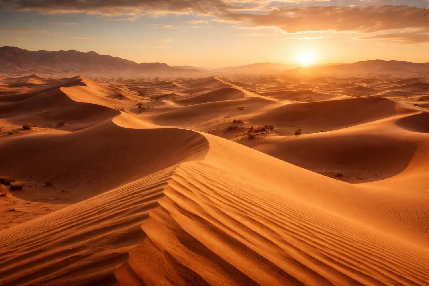
Yet when people picture a desert, they usually picture a sand sea—long ridges, crescent dunes,
high star dunes, and wind-shaped surfaces that seem to move even when they are still.
Gran Desierto de Altar
Location & Continent Continent: North America Country: Mexico State: Sonora Desert System: Sonoran Desert Nearest Well-Known Places: Puerto...
Read More →Tengger Desert
Location & Continent Continent: Asia Country: China Primary Regions: Inner Mongolia (Alxa League), Ningxia, Gansu Approximate Coordinates (Center...
Read More →Badain Jaran Desert
Location & Continent Continent: Asia Country: China Region: Alxa Plateau, Inner Mongolia Autonomous Region (with edges reaching toward...
Read More →Cholistan Desert
Location and Continent The Cholistan Desert sits in South Asia, spread across southern Punjab, Pakistan, mainly within the...
Read More →Sharqiya Sands
Location and Setting Continent: Asia (Arabian Peninsula) Country: Oman Region: Ash Sharqiyah (Eastern Oman) between the interior plains...
Read More →Nefud Desert
Location and Regional Context The Nefud Desert—often written as An Nafud or Al Nafud—is a vast red-sand desert...
Read More →Empty Quarter (Rub’ al Khali) Desert
Location And Continent Continent: Asia Region: Arabian Peninsula in West Asia, forming a vast core of the Arabian...
Read More →Tin-Toumma Desert
Location and Continent The Tin-Toumma Desert is a vast dune plateau in southeastern Niger, set along the Sahel–Sahara...
Read More →Ténéré Desert
Location & Continent Continent: Africa Countries: Niger, Chad Region: South-central Sahara Desert, between the Aïr Mountains and the...
Read More →Simpson Desert
Location & Continent Continent: Australia Country: Australia (Northern Territory, South Australia, Queensland) Coordinates: 24°34′S, 137°25′E Simpson Desert –...
Read More →Great Sandy Desert
Location & Continent Continent: Oceania (Australia) Country / State: Australia — Western Australia (minor extensions toward the Northern...
Read More →Taklamakan Desert
An immense sea of sand in China’s Xinjiang Uyghur Autonomous Region, the Taklamakan is one of Earth’s largest...
Read More →Gurbantünggüt Desert
Location & Continent Continent: Asia Country: China (Xinjiang Uyghur Autonomous Region) Coordinates: 45°N, 86°E Gurbantünggüt Desert – Map...
Read More →Karapinar Desert
Location & Continent Continent: Asia Country: Turkey Coordinates: 37°42′N, 33°33′E Karapınar Desert – Map & Street View ...
Read More →Thar Desert
Location & Continent Continent: Asia Country: India & Pakistan (primarily Rajasthan in India; stretching into Sindh and Punjab...
Read More →Maranjab Desert
Location & Continent Continent: Asia Country: Iran (Isfahan Province – Aran va Bidgol County, near Kashan) Coordinates: 34.3003°N,...
Read More →Polond Desert (Kavir-e Polond / Mozaffari Desert)
Location & Continent Continent: Asia Countries: Iran (South Khorasan Province – within Mozaffari Protected Area) Coordinates: ~34.16°N, 57.70°E...
Read More →Lompoul Desert
Location & Continent Continent: Africa Country: Senegal Coordinates: 15°55′N, 16°40′W Photos of the Lompoul Desert Physical Features Area:...
Read More →18 inventions in Sandy Deserts (Ergs)
In desert geography, those broad sandy tracts are called ergs. Some are immense continental bodies such as the
Rub’ al Khali and the Taklamakan. Others are smaller but still geologically sharp and visually clear,
like Sharqiya Sands in Oman or the coastal dunes of Lompoul in Senegal.
Some are classic mobile dune seas. Others are partly fixed by vegetation, moisture, crusts, or long periods of lower sand activity.
The sandy deserts on this page also show an important truth: not all erg landscapes are built the same way.
One may grow from an old river or delta sediment source. Another may sit inside a tectonic basin. Another may depend on
monsoon winds, trade winds, or seasonally reversing air flow. In one desert, dunes march across an open floor. In another,
they trap lakes between giant ridges. In yet another, winter snow briefly feeds spring plant life before the surface dries again.
A Simple Way to Read Sandy Deserts: look for three things first—
sand supply, wind pattern, and
how much the surface is anchored. That trio explains most of what a sand sea looks like.
What an Erg Really Is
An erg is a very large desert area dominated by wind-blown sand. The word often appears beside
sand sea, and that label fits because many ergs behave like seas in plan view: dune crests rise like waves,
long troughs act like channels, and the whole field records the history of wind the way tree rings record the history of growth.
Small isolated dune patches are better described as dune fields. A true erg is broader, more continuous,
and tied to a long-lived sediment system.
Geologists separate ergs from other sandy surfaces because relief matters.
A sand sheet may hold wide spreads of loose sand but little dune topography.
An erg usually has organized forms—linear dunes, barchans,
star dunes, domes, or mixed ridge systems layered one over another.
In giant sand seas, you often see dunes riding on older dunes, and those in turn resting on still older basin fills.
Old surface, new shape. That is common in the desert.
A second detail matters too: sand is only one grain size in the desert sediment family.
Wind can move dust, silt, and fine sand easily; coarse sand and gravel need more force and usually stay close to the ground.
That is why ergs tend to be made of well-sorted fine to medium sand. The particles are light enough to saltate,
bounce, and creep, yet heavy enough to settle into stable dune bodies when wind energy drops. Usualy, the cleaner the sorting,
the clearer the dune shape.
Erg = broad sand-dominated desert tract.
Dune Field = smaller sandy body, often local.
Sand Sheet = flatter sandy cover with weak dune relief.
Interdune = the lower surface between dunes, sometimes dry, sometimes salty, sometimes wet after rare rain.
How a Sand Sea Forms
No erg appears by accident. A sand sea needs a sustained delivery of sediment, open space for accumulation,
and winds strong enough to organize grains into repeated landforms. Remove any one of those and the landscape changes.
There may still be desert, but not a classic erg.
Sand Supply Comes First
Most large ergs sit downwind from an older sediment store. That store may be an ancient river floodplain, an alluvial fan system,
a drying lake basin, a delta, weathered sandstone, or glacial and periglacial deposits left exposed after climate shifts.
In North America, the Gran Desierto de Altar draws heavily on Colorado Delta sediments.
In Arabia, the red sands of the Nefud are tied to sandstone source rocks.
In Central Asia, basin floors and mountain-fed sediment systems help sustain giant dune bodies.
This is why big sandy deserts often sit in basins rather than on random uplands.
Basins trap sediment. Rivers enter, spread, dry, or shift. Lakes expand and retreat. Fine material is left behind.
Later, the wind reworks it. Over long spans, a basin becomes not just a storage space but a landform factory.
Wind Regime Controls Shape
Wind direction, seasonality, and strength decide what dune pattern develops.
One dominant wind commonly builds crescentic or transverse dunes.
Two dominant directions can favor long linear ridges.
Several competing directions can build star dunes with radiating arms and steep slip faces.
Rarely does one wind story explain an entire erg. Most large sand seas hold mixed forms because local topography, moisture,
vegetation, and seasonal storm paths keep changing the sand budget from one sector to the next.
In some deserts, dune migration is fast enough to measure over a few years with satellite imagery.
In others, the dunes are partly fixed and only the surface skin moves. That difference matters in field reading.
A dune can look dramatic yet be internally stable, while a low crescent dune can shift with surprising speed.
Surface Anchoring Slows or Freezes the Pattern
Not every sandy desert is fully mobile. Vegetation, soil crusts, moisture at depth, evaporite cement, or dense packing can hold dunes in place.
The Badain Jaran Desert is famous for giant dunes that stand high yet are not simple runaway bodies.
The Gurbantünggüt Desert shows how semi-fixed and fixed dunes can still form a large sandy desert,
especially where winter snow and spring moisture help plant cover hold the surface.
So, when a desert is called a sea of sand, that does not always mean endless loose sand blowing freely in every direction.
Some sectors are active. Some are held. Some wake up after storms and quiet down again.
It is a living geomorphic system, not a frozen postcard.
Main Dune Shapes Found in Sandy Deserts
Dune shape is the quickest way to read the wind history of a sandy desert. A sharp ridge, a broad arc, a multi-armed pyramid,
or a low dome each points to a different balance of sand supply,
wind variability, and surface stability.
On large ergs, several dune types often overlap.
| Dune Type | How It Looks | Typical Wind Setting | Where It Shows Up Well |
|---|---|---|---|
| Barchan | Crescent shape with horns pointing downwind | Mostly one dominant wind, limited sand | Nefud sectors, parts of the Thar, local sectors of Central Asian deserts |
| Transverse | Long ridges set across wind direction | One dominant wind, abundant sand | Gran Desierto sectors, parts of the Empty Quarter, parts of Cholistan |
| Linear or Longitudinal | Long narrow ridges, often nearly parallel | Two oblique winds or a narrow sand transport corridor | Simpson Desert, Great Sandy Desert, Sharqiya Sands |
| Star | Pyramidal dune with several arms | Multi-directional winds with net sand build-up | Badain Jaran, Empty Quarter, Gran Desierto de Altar |
| Dome | Rounded mound with weak slipface | Variable winds, lower ridge organization | Gran Desierto sectors and mixed sand sea margins |
| Parabolic | U-shaped dune, often partly anchored by plants | Wind plus some surface moisture or vegetation | Smaller coastal and semi-stabilized dune fields, including parts of Lompoul-type settings |
Star dunes deserve special attention. They are the giants. Modern work on star dunes has shown that they form where winds arrive from several directions,
pile sand into one node, and then keep reworking the flanks without draining the center. That is why the largest star dunes are often found in very large
sand seas with long sediment histories. Their internal layering can be more complex than it looks from the surface.
Linear dunes tell a different story. They are less theatrical from ground level, but geologically they are brilliant records of directional balance.
In Australia, whole landscapes are written as parallel red ridges.
In Arabia and Oman, long sand belts connect one sandy province to another. In these places, shape is not random at all; it is a map of air flow.
Why Sand Covers Only Part of Most Deserts
One of the biggest misunderstandings in desert geography is the idea that a desert is mostly dunes. It usually is not.
Even the Sahara, the best-known hot desert on Earth, is not a single endless dune field.
Broad areas are rock, gravel, stony plains, and dry basins. Sand sheets and dunes cover only a portion of that larger system.
This matters when comparing sandy deserts around the world. A place can be a famous desert but only partly sandy.
A place can also be relatively small, yet almost entirely dune-dominated. So size alone does not tell the full story.
Texture tells the story better: rock desert, gravel desert, salt desert, loess surface, or erg.
Sand tends to gather where topography, sediment, and wind work together for a long time. Elsewhere, finer material is blown away,
coarser lag remains, or crusted surfaces stop dune growth. That is why many desert travelers cross long expanses of firm reg or hamada
before reaching the dramatic dune belts that fill photographs and popular memory.
A Useful Rule: deserts are defined by aridity, not by sand.
Sandy deserts are a special subset inside the wider dryland world.
What Sand Color, Grain Size, and Dune Spacing Tell You
Sand color is more than appearance. Red and orange dunes often point to iron-rich coatings or source rocks.
The Nefud is known for reddish sand. Parts of the Simpson carry vivid red tones from iron oxide coatings.
Pale or honey-colored dunes may reflect cleaner quartz or lighter source sediment, though local mineral mix always matters.
White desert sand is less common in large inland ergs and more likely where gypsum or very pale quartz dominates.
Grain size also shapes form. Fine to medium sands sort well and create clean ripple and slipface patterns.
Very fine sand can build smooth sheets and lower-angle surfaces. Coarser grain mixes often make dunes less neat and can feed lag surfaces between ridges.
Add salt, clay, or carbonate cement and the whole behavior changes again. A dune may look mobile while its lower body is partly hardened.
Dune spacing helps read wind energy and sand volume. Widely spaced tall dunes often signal strong vertical build-up with broad interdunes.
Closely packed low ridges may signal repeated transport over a flatter sand sheet. In giant linear-dune deserts, spacing can be so regular
that satellite imagery looks almost engineered. It is not, of course. It is wind physics written over a basin floor.
Then there is the surface between dunes. Interdunes can be dry, gravelly, salty, crusted, or even wet.
In the Badain Jaran, interdunal lakes are one of the main reasons the desert feels unlike most others.
In Arabian settings, sabkha-like lowlands and saline flats change how dunes climb and end.
In Iran, salt basins near dune margins create sharp boundaries between loose sand and hard white crust.
Main Sandy Deserts by Region
The sandy deserts below show the full spread of erg geography—from giant continental sand seas to smaller dune provinces that still carry a clear
aeolian signature. Some are textbook ergs. Some are better read as
regional dune systems inside larger desert basins. Put together, they show how varied the sandy face of desert Earth really is.
North America
Gran Desierto de Altar
Northwestern Sonora in Mexico holds one of the clearest sandy desert landscapes in North America. This dune region is widely known as
the only active erg on the continent, and it includes some of North America’s most striking
star dunes, linear dunes, and sand sheets.
The dune mass is tied to sediment from the Colorado Delta and nearby local sources, then reworked by strong regional winds.
UNESCO notes dune heights that can reach around 200 meters, which is enough to give the landscape a true sand-sea feel rather than a loose dune patch feel.
The setting is especially useful in geomorphology because volcanic terrain from El Pinacate sits beside the dune system, producing a sharp contrast between
black volcanic surfaces and light mobile sand. That contact makes dune boundaries easy to read, from the ground and from satellite imagery.
Africa
Tin-Toumma Desert
Southeastern Niger’s Tin-Toumma sector belongs to the wide Sahara-Sahel transition zone, yet in form it contains real
sand sea character. Conservation work in the Termit-Tin Toumma landscape describes a mix of mountains,
open desert, plains, and sand seas, which makes this area more varied than the phrase “empty desert” suggests.
For desert studies, Tin-Toumma matters because it links dune geomorphology with survival ecology. It is one of the last strongholds for the
addax, a desert antelope built for extreme dryland life. That link between landform and habitat is easy to miss in broad world-desert lists.
The sandy sectors are not just scenic surfaces; they shape movement corridors, forage opportunities after rare rain, and shelter patterns across a hard climate.
Ténéré Desert
The Ténéré is one of the Sahara’s great names, and for good reason. It occupies a large part of north-central Niger and forms the sandy eastern companion to the Aïr Mountains.
UNESCO’s Aïr and Ténéré Natural Reserves cover a vast protected landscape of about 7.736 million hectares,
and within that space the live dunes of the Ténéré are noted for constant reshaping by wind-driven displacement and deposition.
The desert is not uniform. Some sectors are open sandy plains, some are major dune bodies, and some lie closer to mountain-fed sediment routes.
That contrast is part of what gives the Ténéré its scientific value. It shows how a sandy desert can sit beside massifs, dry drainage lines, and old travel corridors,
all inside one wider Saharan system. Sparse rain, hard evaporation, and broad exposure keep the sand active where supply is adequate.
Lompoul Desert
Senegal’s Lompoul is small when set beside Sahara giants, yet it deserves a place in a world page on sandy deserts because it shows how
coastal dune landscapes can still read as miniature sand seas. The dunes sit between Dakar and Saint-Louis on the Grande Côte,
close enough to the Atlantic that the scene feels half desert, half maritime margin.
Lompoul is not a continental erg. Better to call it a compact dune desert with strong visual clarity.
Its sands are often described as ochre or orange, and the field is ringed by Sahelian scrub rather than by huge internal basins.
That makes it a good reminder that sandy desert form exists on more than one scale. The mechanics remain familiar—wind sorting, dune building, partial stabilization—yet the footprint is modest.
Arabia and Oman
Sharqiya Sands
In eastern Oman, Sharqiya Sands—still often called Wahiba Sands—forms an isolated sand sea rather than an open-ended continental erg.
Educational and field resources place it at roughly 1,500 square kilometers, with dune belts flanked by wadis, mountain margins,
and the Arabian Sea side of the region. Many dunes rise to around 70 meters, and higher crests appear in some sectors.
This desert is especially useful for reading wind interaction. The dune geometry reflects both monsoonal and regional wind controls,
and the ridges often show the long, clean organization expected in a mature sandy system. Unlike giant inland ergs, Sharqiya Sands feels bounded.
You can read its edges. That makes it one of the clearest places to see how a sand sea fits into a larger dryland mosaic of wadis, gravel margins, and coastal influence.
Nefud Desert
The Nefud of northern Saudi Arabia is one of Arabia’s main sand bodies and one of its most recognizable by color.
Britannica describes it as a reddish sandy basin, filled by sand eroded from sandstone formations,
with an area of about 65,000 square kilometers. Its red tone is not cosmetic; it reflects mineral character and source history.
Morphologically, the Nefud is known for broad crescentic dune patterns and large open sandy sectors that stand apart from the harder surfaces around them.
It is also a reminder that Arabian sand deserts connect to one another. The Nefud does not sit alone in a vacuum.
To the south, long dune corridors help tie northern and southern Arabian sand provinces into one wider aeolian story, with the Al Dahna acting as a sandy connector.
Empty Quarter (Rub’ al Khali) Desert
The Rub’ al Khali is the giant of Arabia and one of Earth’s supreme sand landscapes. Its area is commonly given at about
650,000 square kilometers, and it forms the largest part of the Arabian Desert.
In plain terms, this is one of the world’s largest continuous bodies of sand.
The desert stretches roughly 1,000 kilometers in length and about 500 kilometers in width.
Dune forms vary from long ridge systems to towering star dunes, with saline flats and hard interdunes appearing in places.
Heat is extreme, evaporation is intense, and the structural basin setting has helped trap vast sediment bodies over long spans of time.
If a person wants to understand the phrase sand sea in its biggest hot-desert sense, this is one of the first places to study.
South Asia, Turkey, and Iran
Cholistan Desert
Southern Punjab’s Cholistan Desert lies along the eastern side of Pakistan and continues the sandy and semi-sandy terrain that grades toward the Thar system.
Britannica describes Cholistan as a barren desert tract, while soil descriptions for Pakistan note sandy desert soils, shifting sand, and clayey floodplain surfaces.
That mix is important: Cholistan is not only dunes. It is a desert plain with sandy tracts, interdunal surfaces, and old drainage context.
Rainfall is scarce and unreliable, and recent climate work keeps returning to water stress as the central environmental issue.
The desert’s geomorphology is tied to the old Hakra channel zone, desert plains, and mobile sandy belts. So Cholistan belongs in a sandy desert discussion,
though it should not be simplified into “nothing but dunes.” Its value lies exactly in that transition—river legacy meeting aeolian reshaping.
Thar Desert
The Thar is one of the world’s best-known inhabited deserts and a major sandy region across India and Pakistan.
Rainfall varies strongly from west to east, with broad estimates from about 100 millimeters or less in the drier west
to about 500 millimeters in the east. That gradient matters because it controls vegetation cover, dune activity, and land use.
The Thar holds many classic dune forms—barchans, transverse dunes, and stabilized ridges—yet it is not empty country.
Agriculture, settlements, grazing, and seasonal mobility shape the surface alongside the wind. This human presence makes the Thar a good case for reading
active sand and anchored sand together.
It is a sandy desert, yes, though one far more textured than the stereotype of a vacant sea of dunes.
Karapinar Desert
Central Turkey’s Karapinar stands apart from giant ergs. It is better understood as a wind-erosion and dune field landscape
in a dry continental setting, and as one of the clearest desertification case studies in Anatolia. Turkish materials on the area note average annual precipitation near
275 millimeters, with very dry summer months and large surfaces exposed to wind erosion.
Historical work on Karapinar also points to a rehabilitation effort that began in the early 1960s after mobile sands threatened the town and surrounding land.
That story matters because it shows a sandy surface in motion, then partly stabilized by management and vegetation work.
So Karapinar may be smaller and less classic than Arabia’s or China’s giant ergs, still it belongs here as a desertified sandy terrain where dune behavior and land care meet directly.
Maranjab Desert
Maranjab sits on the northern side of Iran’s Dasht-e Kavir basin near Aran va Bidgol and Kashan.
It is not a continent-scale erg, but it is a very clear sand desert sector with dunes, salt flats, seasonal wetlands,
and the old Maranjab caravanserai, built in 1603. The mix of dune fields and salt-affected surfaces gives the area a strong geomorphic identity.
What makes Maranjab useful in a world comparison is the boundary between loose aeolian sand and
salt-basin terrain. In many world lists, sandy deserts are treated as if all their surfaces were alike.
Maranjab shows why that is false. Here, the dune body and the kavir floor sit close together, and the contrast between them is part of the landscape’s real meaning.
Polond Desert
The Polond Desert, often linked with Kavir-e Polond and the Mozaffari protected landscape in eastern Iran, is another place where a sandy desert must be read in basin context.
It belongs to Iran’s interior arid belt, where dune movement, groundwater decline, and surface exposure can all affect the spread and vigor of sand bodies.
In practical field terms, Polond is best approached as a regional dune desert rather than a giant self-contained erg.
Its importance lies in how clearly it shows aeolian shaping within a wider Iranian dryland system of basins, salt surfaces, wind corridors, and patchy vegetation.
That makes it valuable for readers who want more than a ranking list. Not every sandy desert needs continental scale to teach a continental lesson.
China and Inner Asian Basins
Tengger Desert
The Tengger Desert of northern China covers roughly 36,700 to 40,000 square kilometers depending on boundary treatment.
It lies in a dry interior setting where dune activity, sand transport, and anti-desertification work have all been studied closely.
Recent remote-sensing work has measured average dune migration in sampled areas at roughly 2.1 to 3.7 meters per year,
which gives a direct modern number for a moving sandy surface.
The Tengger is useful because it combines classic sand desert form with present-day surface change that satellites can track.
It also sits close to another famous dune province, the Badain Jaran, so the contrast is instructive:
the Tengger often reads as an active migrating desert, while Badain Jaran is celebrated for giant stabilized dunes and lakes between them.
Badain Jaran Desert
Badain Jaran is one of the world’s most striking sandy deserts. The wider desert is commonly given at about
49,000 square kilometers, and the UNESCO World Heritage property added in
2024 covers more than 726,000 hectares.
This is China’s third-largest desert and its second-largest drifting desert.
What sets it apart is the pairing of mega-dunes and interdunal lakes.
UNESCO notes a tallest stabilized dune with a relative height of about 460 meters.
Many descriptions count more than 100 spring-fed lakes between dune masses. That combination is rare enough to make the desert stand out even among global sand seas.
In simple terms: giant, high, partly held dunes with water trapped between them. Few places do that so cleanly.
Taklamakan Desert
The Taklamakan fills the heart of the Tarim Basin in Xinjiang and ranks among Earth’s largest sandy deserts.
Britannica gives its area at about 320,000 square kilometers, with an east-west length near
960 kilometers. This is basin desert geography in textbook form: a huge enclosed lowland ringed by mountains,
fed by rivers that enter from the margins and then fade out into sand.
The desert has long symbolized remoteness, but scientifically it is about sediment routing and edge-water control.
Rivers from the Kunlun and other bordering highlands do not cross the whole desert; many penetrate partway, then vanish.
Around the margins lie corridors, oases, and transport routes. In the center, vast sandy surfaces dominate.
Few places show more clearly how a closed basin can gather, sort, and preserve a giant aeolian system.
Gurbantünggüt Desert
The Gurbantünggüt in the Junggar Basin is China’s second-largest desert and the country’s largest fixed or semi-fixed sandy desert.
Multiple studies place its area near 48,800 square kilometers. Annual precipitation is low—
usually about 70 to 150 millimeters—yet winter snow cover is an unusual and very important part of its ecology.
This is one of the best places to see how a sandy desert can be dry and still not behave like a classic fully mobile erg.
Many dune surfaces are held partly by shrubs, biological crusts, and the moisture pulse from winter snowfall.
The result is a sandy landscape that supports a brief spring bloom and a more anchored dune geometry than in hotter, looser sand seas.
It broadens the definition of what a major sandy desert can look like.
Australia
Simpson Desert
Australia’s Simpson Desert is one of the world’s great linear-dune deserts.
Geoscience Australia lists its area at about 176,500 square kilometers.
NASA and South Australian park material describe dune ridges stretching for more than 100 kilometers,
with parallel red sand belts extending across hundreds of kilometers of country.
This is the place to study dune rhythm. Ridge after ridge, often closely spaced, with orientation controlled by long-term wind balance.
Some dune crests rise to around 40 meters, but the bigger visual effect comes from repetition rather than raw height.
The Simpson proves that a sandy desert does not need giant star dunes to feel vast. Order can be just as powerful as height.
Great Sandy Desert
The Great Sandy Desert is Australia’s second-largest desert, with an area of about 267,250 square kilometers.
It stretches across northern Western Australia into the interior drylands and merges by degrees with neighboring desert country.
Britannica notes long linear dunes on the order of 8 to 9 meters in some sectors, with dune crests still active even though the main dune-building phase eased long ago.
Like the Simpson, this desert is vital for reading parallel ridge systems, though the Great Sandy also carries more varied plains,
rocky sectors, and transitional margins. It is not a single uninterrupted wall of dunes. Better to think of it as a large sandy province with strong linear organization,
still active at the crests, spread across a much broader desert setting.
A Side-by-Side Look at Major Sandy Deserts
| Desert | Approximate Scale | Typical Sandy Character | What Stands Out Most |
|---|---|---|---|
| Rub’ al Khali | ~650,000 km² | Gigantic continuous sand sea | One of Earth’s largest uninterrupted sandy bodies |
| Taklamakan | ~320,000 km² | Basin-filled erg | Huge interior desert ringed by mountains |
| Great Sandy Desert | ~267,250 km² | Linear dune province | Long ridge systems across Australian drylands |
| Simpson Desert | ~176,500 km² | Parallel red linear dunes | Exceptional ridge repetition and length |
| Nefud | ~65,000 km² | Reddish sandy basin | Classic Arabian red sand landscape |
| Badain Jaran | ~49,000 km² | Mega-dunes with lakes | Very high stabilized dunes and interdunal lakes |
| Gurbantünggüt | ~48,800 km² | Fixed and semi-fixed sandy desert | Snow-fed spring pulse in a major dune desert |
| Tengger | ~36,700–40,000 km² | Active migrating dunes | Measured modern dune movement |
| Sharqiya Sands | ~1,500 km² | Bounded isolated sand sea | Clear ridge patterns in a compact Omani setting |
| Gran Desierto de Altar | ~5,700 km² dune region | Active erg with star dunes | North America’s clearest active sand sea |
Tables help, but they can also flatten reality. The better reading is this:
large area does not always mean high dune relief,
and small area does not mean low scientific value.
A compact dune field may reveal wind control more clearly than a giant mixed basin.
A giant sand sea may include stable sectors, wet interdunes, or crusted floors that do not fit the postcard version of desert sand.
Life in Erg Deserts
Sandy deserts can look bare from afar, still they often support tightly adapted life. The limits are harsh:
low rainfall, high evaporation, heat, sparse shade, and shifting substrate. Yet dune systems create microhabitats.
Slip faces, crest lines, lee slopes, interdunes, and moisture-trapping pockets do not behave the same way.
Even a few centimeters of extra moisture can change what survives.
In some sandy deserts, ephemeral plants exploit short wet windows after rain or snowmelt.
The Gurbantünggüt is famous for this, because winter snow helps set off a spring flush.
In other places, deep-rooted shrubs anchor margins and lower dunes. In the Thar and Cholistan, vegetation cover varies strongly with rainfall and land use.
In the Empty Quarter, life becomes patchier and more tied to margins, depressions, and rare moisture opportunities.
Animal movement also follows landform. Antelope, gazelles, foxes, reptiles, and invertebrates use the dune field not as an empty expanse but as a patterned surface.
Windward slopes, sheltered hollows, crusted interdunes, and shrub pockets all matter. In Tin-Toumma, that patterned habitat supports one of the Sahara’s last addax populations.
In the Ténéré, broad protected landscapes matter because the animal story cannot be separated from the landform story.
For readers used to thinking of deserts as dead land, sandy deserts give a better lesson:
life thins out, but it does not vanish evenly. Distribution becomes precise.
The harsher the setting, the more precise it gets.
How People Read, Cross, and Manage Sand Seas
Human movement across sandy deserts has always depended on margin reading. Water, firm ground, passable corridors, and seasonal timing matter more than straight lines.
Even giant ergs are rarely crossed through their most chaotic core if a firmer route exists nearby.
Historically, travel often followed oasis chains, basin margins, dry valleys, and low-interdune belts.
In modern times, roads, tracks, and satellite navigation help, but the landform logic remains the same.
Settlement patterns usually sit at the edge of sand, not in the highest dune belts. That is obvious in the Taklamakan basin margins and in many Arabian desert settings.
The same pattern appears in smaller systems too. Sand may look open and simple from above, but on the ground it can be slow, unstable, and expensive to work with.
Dune migration can bury wells, roads, fences, and fields if the surface is active enough.
Management responses vary. In Karapinar, planting and controlled grazing were used to reduce wind erosion and hold sand.
In parts of northern China, shelterbelts, checkerboard barriers, vegetation planting, and water control have all been used to reduce sand encroachment on roads and farmland.
Some projects work well locally. Some work only with constant upkeep. Sand is patient.
One thing should be kept clear: a stabilized dune is not a dead dune.
It may reactivate if vegetation is removed, if groundwater drops, if grazing pressure rises, or if wind energy and sediment supply shift.
Sandy deserts remember disturbance.
Why Some Sandy Deserts Expand While Others Stabilize
A sandy desert expands when the balance turns in favor of available sediment and
wind transport, while vegetation, crusts, moisture, or topographic traps are too weak to hold the surface.
That can happen after drought, overgrazing, river change, groundwater fall, vegetation loss, or direct land disturbance.
Once loose sand is exposed, the wind takes over fast.
Stabilization happens for the opposite reasons. Plant cover rises. Moisture improves. Surface crusts thicken. Dune toes become anchored.
In some sandy deserts, this is a natural shift tied to climate oscillation. In others, land management pushes the surface toward lower mobility.
The Australian examples show many ridges that still move at the crest while remaining broadly organized and partly anchored.
The Gurbantünggüt shows how cold-season moisture can hold dunes more than outsiders expect.
Basin hydrology can also change the picture. A falling lake exposes sand. A river avulses and creates new sediment supply.
A saline lowland hardens and blocks migration. Springs support vegetation in one corridor but not the next.
This is why two neighboring dune fields may behave very differently even under a similar climate.
There is a broader dryland lesson here too. Global drylands are expanding in many regions, and aridity is rising across large parts of the planet.
That does not mean every place will become a giant erg. It does mean that surface vulnerability matters more than ever.
Sandy ground reacts quickly when protective cover is lost.
Further Reading and Data Used
- Encyclopaedia Britannica entries on erg deserts, sand dunes, the Sahara, the Thar Desert, the Nefud, the Rub’ al Khali, the Taklamakan, the Great Sandy Desert, and Al Wahibah Dunes.
- UNESCO World Heritage material for El Pinacate and Gran Desierto de Altar, Aïr and Ténéré Natural Reserves, and Badain Jaran Desert – Towers of Sand and Lakes.
- U.S. Geological Survey material on dune types, aeolian sediment systems, and dune geomorphology.
- NASA Earth Observatory pages on the Simpson Desert and the Great Sandy Desert.
- Geoscience Australia figures for Australian desert areas.
- Royal Geographical Society teaching material for Sharqiya Sands in Oman.
- Research summaries and peer-reviewed studies on dune migration in the Tengger Desert, fixed and semi-fixed dunes in the Gurbantünggüt, and sandy desert dynamics in Iran and Turkey.
- Conservation material from Zoological Society of London on the Termit-Tin Toumma landscape.