
Desert cities are not built against the desert as much as they are built with it. Their streets, water systems, housing patterns, shade structures, food supply, and public spaces all respond to the same basic condition: rain is limited, heat can be intense, and every drop of water has a job. Some desert cities grew beside rivers. Some grew on coasts where desalination later changed the scale of urban life. Others expanded from oases, caravan stops, mining towns, port settlements, or planned capitals.
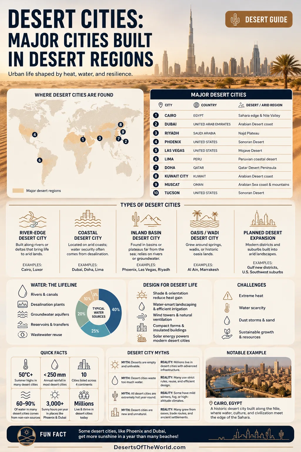
A desert city is more than a city surrounded by sand. It may sit on a rocky plateau, a gravel plain, a dry basin, a coastal fog desert, or the edge of a river valley inside a larger arid zone. What links these places is the way climate shapes urban life. Water supply, heat management, shade, soil, wind, and distance from farmland matter as much as roads and buildings.
What Counts as a Desert City?
A desert city is usually a large settlement located in, beside, or strongly shaped by a desert or arid region. Many of these cities fall within hot desert climate zones, often marked as BWh in the Köppen climate system. Others sit in cold desert, semi-arid, or coastal desert settings where rainfall stays low but humidity, fog, or nearby mountains change the feel of the climate.
Not every desert city looks the same. Cairo grew along the Nile at the edge of the Sahara. Lima sits on a dry Pacific coast where fog is more common than rain. Phoenix spreads across the Sonoran Desert. Las Vegas occupies a basin in the Mojave Desert. Dubai, Doha, Kuwait City, and Abu Dhabi show how coastal desert cities can grow when ports, desalination, transport, and managed infrastructure work together.
| Desert City Type | Main Desert Setting | Typical Water Source | Examples |
|---|---|---|---|
| River-Edge Desert City | Dry land beside a river valley or delta | River water, canals, reservoirs, treatment systems | Cairo, Luxor, parts of Khartoum |
| Coastal Desert City | Arid coast with low rainfall | Desalination, groundwater, imported or river-fed water | Dubai, Doha, Kuwait City, Lima, Muscat |
| Inland Basin City | Dry basin, plateau, or valley away from the sea | Groundwater, river transfers, reservoirs, reclaimed water | Phoenix, Las Vegas, Riyadh, Tucson |
| Oasis or Wadi-Based City | Settlement near springs, wadis, or historic oasis lands | Springs, aquifers, seasonal runoff, managed channels | Al Ain, Marrakesh, parts of Muscat |
| Planned Desert Expansion | Modern districts built into arid land | Regional water networks, desalination, reuse systems | New districts around Gulf cities, desert suburbs in the U.S. Southwest |
Major Desert Cities and Their Regions
Desert cities often become regional centers because they sit where movement is possible: a river crossing, a port, a mountain pass, a trade route, an oil and gas service area, a government center, or a rail and highway junction. The desert may look empty on a map, but the best urban sites in arid lands are rarely random.
| City | Country | Desert or Arid Region | Urban Desert Pattern |
|---|---|---|---|
| Cairo | Egypt | Sahara edge and Nile Valley | A river-fed metropolis where the Nile creates a narrow green corridor through dry land. |
| Dubai | United Arab Emirates | Arabian Desert coast | A coastal desert city shaped by port trade, desalination, managed landscaping, and rapid urban growth. |
| Riyadh | Saudi Arabia | Najd plateau, Arabian Peninsula | An inland desert capital where heat, dust, groundwater history, and large-scale supply networks shape daily life. |
| Phoenix | United States | Sonoran Desert | A basin city using river systems, canals, groundwater management, desert landscaping, and heat-adapted planning. |
| Las Vegas | United States | Mojave Desert | A dry-basin city tied closely to Colorado River water, reuse systems, and strict outdoor water rules. |
| Lima | Peru | Peruvian coastal desert | A foggy coastal desert capital dependent on rivers descending from the Andes. |
| Doha | Qatar | Qatar desert peninsula | A Gulf desert city where coast, desalination, heat, humidity, and compact districts all matter. |
| Kuwait City | Kuwait | Arabian Desert coast | A low-lying coastal desert capital with dry summers, winter rainfall, and major dependence on desalinated water. |
| Muscat | Oman | Arabian Sea coast and arid mountain edge | A coastal desert city squeezed between mountains and sea, with wadis and steep landforms shaping expansion. |
| Tucson | United States | Sonoran Desert | A desert basin city known for dryland ecology, seasonal monsoon rain, and water-aware urban planning. |
Why People Build Major Cities in Desert Regions
Deserts can be hard places to live, but they are not empty places. People build cities in arid regions when the location offers movement, water access, minerals, trade, coastlines, open land, or strategic position along routes between other regions. The pattern repeats across continents.
- River corridors: A river can turn a desert edge into a long urban spine. Cairo is the clearest example, with the Nile supporting settlement where surrounding land stays dry.
- Coastal access: Ports can make desert coasts powerful urban sites. Dubai, Doha, Kuwait City, Muscat, and Lima all show this pattern in different climates.
- Oases and springs: Some cities grew near reliable water points before modern pipes, dams, and desalination plants changed their scale.
- Crossroads: Desert cities often sit where routes meet: caravan tracks in the past, highways, rail lines, airports, and logistics corridors today.
- Open land for expansion: Dry plains and basins can allow wide roads, large districts, airports, solar farms, and planned suburbs, though this also raises water and heat costs.
Built well, a desert city feels like a practical answer to a difficult landscape. Built poorly, it becomes expensive to cool, thirsty to maintain, and uncomfortable on foot. The difference is not the desert itself. It is planning.
Water Is the Real Map of a Desert City
In a humid city, water can feel like background infrastructure. In a desert city, water is the base map. It decides where people settled first, how far suburbs can spread, which trees survive, what farms can grow nearby, and how public space feels in summer.
Many desert cities use a mix of sources rather than one simple supply. These may include rivers, groundwater, dams, desalination, recycled wastewater, stormwater capture, and long-distance transfers. The mix changes over time as population grows and climate pressure increases.
| Water Strategy | How It Works | Where It Appears | Why It Matters |
|---|---|---|---|
| River Dependence | Urban water comes from a nearby river or river-fed system. | Cairo, Lima, Phoenix | It can support large populations, but upstream flow, snowpack, dams, and seasonal changes affect supply. |
| Desalination | Seawater is treated to remove salt and make it usable. | Dubai, Doha, Kuwait City, Abu Dhabi | It allows coastal desert cities to grow far beyond local rainfall limits. |
| Groundwater | Water is pumped from aquifers beneath the city or region. | Riyadh, Phoenix, Tucson, oasis cities | It can support growth, but long-term pumping must be managed carefully. |
| Reclaimed Water | Treated wastewater is reused for irrigation, industry, or landscape needs. | Las Vegas, Gulf cities, U.S. Southwest cities | It reduces pressure on drinking-water supplies and keeps some urban greenery possible. |
| Water-Sensitive Landscaping | Native plants, xeriscaping, shade trees, and drip irrigation replace high-water lawns. | Phoenix, Las Vegas, Tucson, Dubai districts | It lowers outdoor demand while keeping streets and parks usable. |
Cairo: A River City at the Sahara Edge
Cairo is often described through its monuments and dense neighborhoods, but its desert setting is just as useful for understanding the city. The Nile creates a long green ribbon through northeastern Africa. Outside that corridor, dry land begins quickly. This contrast explains why Cairo’s older growth follows the river valley while newer districts extend toward desert plateaus.
The city is not a classic sand-dune settlement. It is a river-edge desert metropolis. The Nile shapes transport, farming, drinking water, soil, and the layout of older urban land. Without the river, a city of this scale would not have grown here in the same way.
Cairo also shows a common desert-city pattern: the oldest livable strip is narrow, but modern expansion reaches into surrounding dry land. New roads, satellite districts, and desert-edge construction can open space, yet they also require water delivery, shade planning, and careful heat design. In a dry climate, distance has a cost.
Dubai: A Coastal Desert Metropolis
Dubai sits on the Arabian Gulf coast, with the Arabian Desert inland. Its climate is hot and arid, with most rainfall falling in winter. The city’s growth shows how coastal access can change the limits of desert urbanism. A port, airport, road networks, desalination, district cooling, and planned infrastructure allow dense urban life in a place where rainfall alone could never support it.
Dubai also has two desert identities. One is the highly urban coastline, with towers, ports, and transport corridors. The other is the inland desert, with dunes, gravel plains, conservation reserves, and native dryland habitats. Good desert-city writing should keep these two landscapes separate. The city is not the whole desert, and the desert is not only a scenic background for the city.
Coastal desert cities like Dubai face a special blend of heat and humidity. Shade helps, but air movement, building orientation, reflective surfaces, shaded transit stops, and indoor-outdoor transitions matter too. Streets that ignore heat become empty at midday. Streets that manage shade and access stay more usable.
Riyadh: An Inland Desert Capital
Riyadh grew in the interior of the Arabian Peninsula, far from the sea. Its setting on the Najd plateau gives it a different urban logic from Gulf coastal cities. Here, the desert is not a shoreline condition but an inland climate of heat, dryness, dust, and wide seasonal swings.
Older settlement patterns in central Arabia depended on wells, oases, wadis, and local routes. Modern Riyadh works at a much larger scale, using national water systems, roads, new districts, and planned development. That shift from oasis-scale settlement to large metropolitan region is one of the clearest stories in desert urban growth.
Inland desert cities need more than air-conditioned buildings. They need shaded pedestrian routes, dust-aware design, drought-tolerant planting, and public spaces that work in cooler hours. A desert capital must think about daily rhythm as much as skyline.
Phoenix: The Sonoran Desert as an Urban Basin
Phoenix lies in the Sonoran Desert, a biologically rich desert known for saguaro cactus, dry washes, mountain preserves, summer heat, and seasonal monsoon storms. The city grew in a basin where canals, river systems, agriculture, highways, and suburban development reshaped the desert floor.
Unlike many coastal desert cities, Phoenix has no sea beside it. Its water story includes the Salt and Verde river systems, groundwater, reclaimed water, and Colorado River supplies through regional infrastructure. This makes Phoenix a strong example of a desert city where engineering and natural hydrology are tightly linked.
The Sonoran Desert also matters as an ecosystem, not just a climate label. Native plants such as palo verde, mesquite, creosote bush, and cactus handle dryness in ways lawns cannot. In desert neighborhoods, plant choice is not decoration. It is water policy made visible.
Las Vegas: A Mojave Desert City Built Around Water Discipline
Las Vegas sits in the Mojave Desert, one of the driest regions in North America. The city’s image can distract from its deeper urban lesson: a dry city can grow only when water supply, reuse, outdoor demand, and public rules are managed closely.
Southern Nevada relies heavily on the Colorado River system, especially Lake Mead. Because rainfall is low, the city has placed strong focus on turf removal, wastewater reuse, seasonal watering rules, and conservation messaging. The result is a desert-city model where outdoor water use receives close attention.
The Las Vegas Valley also shows the challenge of wide desert urban form. Low-density growth spreads heat-absorbing surfaces, lengthens infrastructure, and increases the need for shaded mobility. In a desert basin, land may appear open, but the real limit is often water and heat, not space.
Lima: A Fog Desert Capital on the Pacific Coast
Lima is one of the most unusual desert cities on Earth. It sits on Peru’s dry Pacific coast, where rain is scarce, yet fog and low cloud can linger for long periods. The nearby Pacific, the cold Humboldt Current, the Andes, and coastal desert conditions combine to create a city that can feel gray and humid while still being extremely dry by rainfall standards.
Lima depends on rivers that descend from the Andes across the coastal desert. This creates a tight link between city life, mountain water, river valleys, and dry coastal land. The city is not an oasis in the classic palm-spring sense. It is a coastal river-valley desert city.
This difference matters. Fog does not replace a dependable drinking-water system. A city may feel damp in the morning and still receive very little usable rain over the year. For visitors and readers, Lima is a useful reminder that deserts are not always blazing blue skies and dunes. Some are cool, cloudy, coastal, and dry.
Doha and Kuwait City: Gulf Desert Urbanism
Doha and Kuwait City share a Gulf coastal desert setting, but each has its own urban form. Both face heat, limited rainfall, dust, saline coastal conditions, and high water demand. Both also show how desalination can support city life where natural freshwater is limited.
In Gulf desert cities, the sea is both an edge and a supply source. Ports, waterfront districts, cooling breezes, desalination plants, and coastal roads all influence the shape of the city. Yet the inland desert is never far away. Heat, dust, and sand movement still affect buildings, roads, and public space.
These cities also show why desert planning cannot focus only on rainfall. Humidity, nighttime temperatures, energy demand, air-conditioned mobility, and shaded outdoor design are part of the same urban equation.
Muscat: A Desert City Between Mountains and Sea
Muscat has a setting unlike the wide-basin cities of Phoenix or Las Vegas. It sits along the Gulf of Oman, where rugged mountains press close to the coast. This makes urban expansion more constrained and more linear. Roads, districts, harbors, and neighborhoods must work around steep landforms and narrow coastal space.
The city’s desert identity includes rocky slopes, wadis, dry heat, coastal humidity, and mountain-shadow effects. Seasonal runoff can move quickly through wadis, so dryland drainage is part of the city’s physical logic. In arid regions, a channel that looks dry most of the year can still shape safe urban design.
How Desert Climate Changes the Shape of a City
Desert climate affects the city in plain, visible ways. Streets need shade. Parks need the right plants. Roofs and walls absorb or reflect heat. Pavement stores daytime warmth and releases it after sunset. Winds can carry dust through open corridors. Water pipes, canals, and storage systems become part of the city’s identity.
The main design questions are practical:
- Can people walk safely between transit, shops, homes, and schools during hot months?
- Does the city plant trees and shrubs that match local water limits?
- Are buildings oriented to reduce heat gain?
- Can treated wastewater support parks without using drinking water?
- Do roads, drainage channels, and underpasses handle sudden short storms?
- Does urban growth protect natural washes, dunes, rocky habitats, and desert preserves?
Small details matter in desert cities. A shaded bus stop can change a daily commute. A tree species with deep drought tolerance can survive where a thirsty lawn fails. A narrow street with shade can feel cooler than a wide exposed boulevard. In the desert, comfort often comes from many modest decisions stacked together.
Heat, Shade, and the Urban Heat Island
Desert cities already start hot. Urban materials can make them hotter. Asphalt, concrete, dark roofs, glass walls, parking lots, and wide unshaded roads absorb solar energy during the day and release heat after sunset. This is the urban heat island effect.
In desert regions, the heat island can be especially hard on night comfort. If the city does not cool down after dark, homes, streets, and public spaces remain stressful for longer hours. That is why many desert cities now focus on cool roofs, shaded sidewalks, lighter paving, urban trees, and heat-aware public design.
| Heat Challenge | Desert-City Response | Urban Benefit |
|---|---|---|
| Exposed sidewalks | Arcades, shade sails, trees, covered transit stops | Safer walking and more usable public space |
| Heat-storing pavement | Lighter surfaces, reduced asphalt, shaded parking | Lower surface temperatures and better nighttime comfort |
| High outdoor water demand | Xeriscaping, native plants, drip irrigation, reclaimed water | Lower pressure on drinking-water supplies |
| Dust and wind exposure | Wind-aware street layout, planted buffers, protected open space | Cleaner, more comfortable streets |
| Sudden desert storms | Wadi protection, washes, detention basins, permeable areas | Safer drainage during short heavy rain events |
Desert Cities Are Not All Sand Dunes
A common mistake is to picture every desert city beside rolling dunes. Many are not. Phoenix is surrounded by rocky mountains, dry washes, cactus landscapes, and alluvial fans. Lima belongs to a coastal desert marked by fog and river valleys. Cairo sits beside a river corridor, not in open dune fields. Muscat is defined by mountains and coast. Riyadh sits on an inland plateau. Las Vegas lies in a dry basin ringed by mountains.
Desert landforms include gravel plains, salt flats, wadis, badlands, rocky slopes, playas, mesas, dunes, coastal terraces, and dry riverbeds. These landforms affect how cities drain, where roads can run, where buildings are stable, and which areas should remain open.
So, a desert city is best understood by asking three questions: Where does its water come from? What kind of desert surrounds it? How does the city handle heat?
Older Desert Knowledge Still Matters
Long before modern desalination plants and concrete expressways, desert settlements used careful building habits. Thick walls slowed heat gain. Courtyards created shade and privacy. Narrow lanes reduced sun exposure. Wind towers and shaded markets helped air move. Oases used palms and layered planting to protect crops below. Qanats, aflaj, wells, cisterns, and canals moved water with care.
Modern desert cities do not need to copy old forms exactly, but they can still learn from them. Shade before decoration. Water matched to use. Streets sized for comfort. Public space placed where people can actually use it. Buildings that respect sun direction. Simple ideas, but easy to forget.
What Makes a Desert City Livable?
A livable desert city does not try to erase the desert. It reduces the harshest parts of the climate while keeping the landscape’s limits in view. The strongest examples combine reliable water systems with local plant palettes, shaded mobility, heat-aware buildings, and public spaces that work outside the mildest months.
- Compact districts reduce long trips and make shaded streets easier to maintain.
- Native and drought-tolerant planting supports shade without wasting water.
- Reclaimed water helps parks and landscapes survive without using treated drinking water where reuse is allowed.
- Cooler materials reduce heat storage on roofs, walls, and paved surfaces.
- Protected dry channels keep natural drainage visible and safer during sudden storms.
- Transit shade matters because waiting in the sun can be the hardest part of a trip.
A desert city succeeds when daily life feels possible without pretending the climate is something else.
Desert Cities Compared by Water Setting
The easiest way to compare desert cities is not by skyline or population. It is by water setting. Cities in the same desert climate may live on very different water systems.
| City | Primary Desert Context | Water Setting | Useful Comparison |
|---|---|---|---|
| Cairo | Sahara edge | Nile river corridor | Shows how a river can support a huge city beside arid land. |
| Lima | Coastal desert | Andean rivers crossing a dry coast | Shows that foggy coastal deserts can still be very dry in usable rainfall. |
| Dubai | Arabian Desert coast | Desalination and managed urban systems | Shows how coastal infrastructure can expand a desert city’s scale. |
| Riyadh | Inland plateau desert | Groundwater history and large supply networks | Shows the challenge of supporting a large inland desert capital. |
| Phoenix | Sonoran Desert basin | River systems, groundwater, and regional delivery | Shows how desert ecology and water engineering meet in a broad metro area. |
| Las Vegas | Mojave Desert basin | Colorado River system and reclaimed water | Shows how strict conservation can become part of city identity. |
The Future of Major Cities in Desert Regions
More people now live in arid and water-stressed urban regions than many readers realize. Desert cities will continue to grow where jobs, ports, transport, education, services, and government functions draw people in. Growth alone is not the issue. The question is whether that growth respects heat, water, landforms, and ecosystems.
The next generation of desert cities will likely be judged by practical measures: lower water loss, better reuse, shade along daily routes, cooler buildings, safer drainage, protected desert habitats, and public spaces that remain usable outside the mild season.
Some of the best desert-city ideas are not futuristic. They are plain: plant the right trees, waste less water, shade the walk, reuse what can be reused, build with the sun in mind, and leave dry washes enough room to work. In the desert, that kind of planning is not a luxury. It is the city’s survival craft.
Sources
- UN-Habitat — World Cities Report 2024: Cities and Climate Action (urban climate pressure, heat, drought, and adaptation context)
- World Bank — Climate and Development in the Middle East and North Africa (regional water scarcity and arid-climate development context)
- NOAA NCEI — U.S. Climate Normals (official climate normals access for U.S. cities, including Phoenix and other desert-region stations)
- National Weather Service — Las Vegas Climate Book (Las Vegas climate records and normals)
- Government of Dubai Media Office — Geographic Location, Demographics & Climate (Dubai location, coastal setting, temperature, and rainfall context)
- Inter-American Development Bank — Water in Peru’s Desert Capital (Lima’s desert-coast water setting)
- City of Phoenix — Sonoran Preserve (official Phoenix desert preserve context)
- U.S. Bureau of Land Management — Sonoran Desert National Monument (Sonoran Desert landscape and conservation setting)
- World Meteorological Organization — Cairo Climate Information (Cairo climate normals and weather context)
- World Meteorological Organization — Riyadh Climate Information (Riyadh climate normals and arid-city context)
- Visit Qatar — Qatar Climate (Doha and Qatar desert climate, rainfall, and seasonal context)
- Kuwait Meteorological Department — Climate (Kuwait climate and seasonal rainfall context)