
Deserts often look empty on a map, yet history tells a different story. The Sahara, Taklamakan, Gobi, Arabian Desert, Mojave, Atacama, and other arid regions acted as filters for movement. They slowed people down, forced routes toward water, and made certain towns valuable because they sat near wells, oases, mountain gaps, or caravan paths. A desert was rarely just a barrier. In many periods, it was a route system with strict rules.
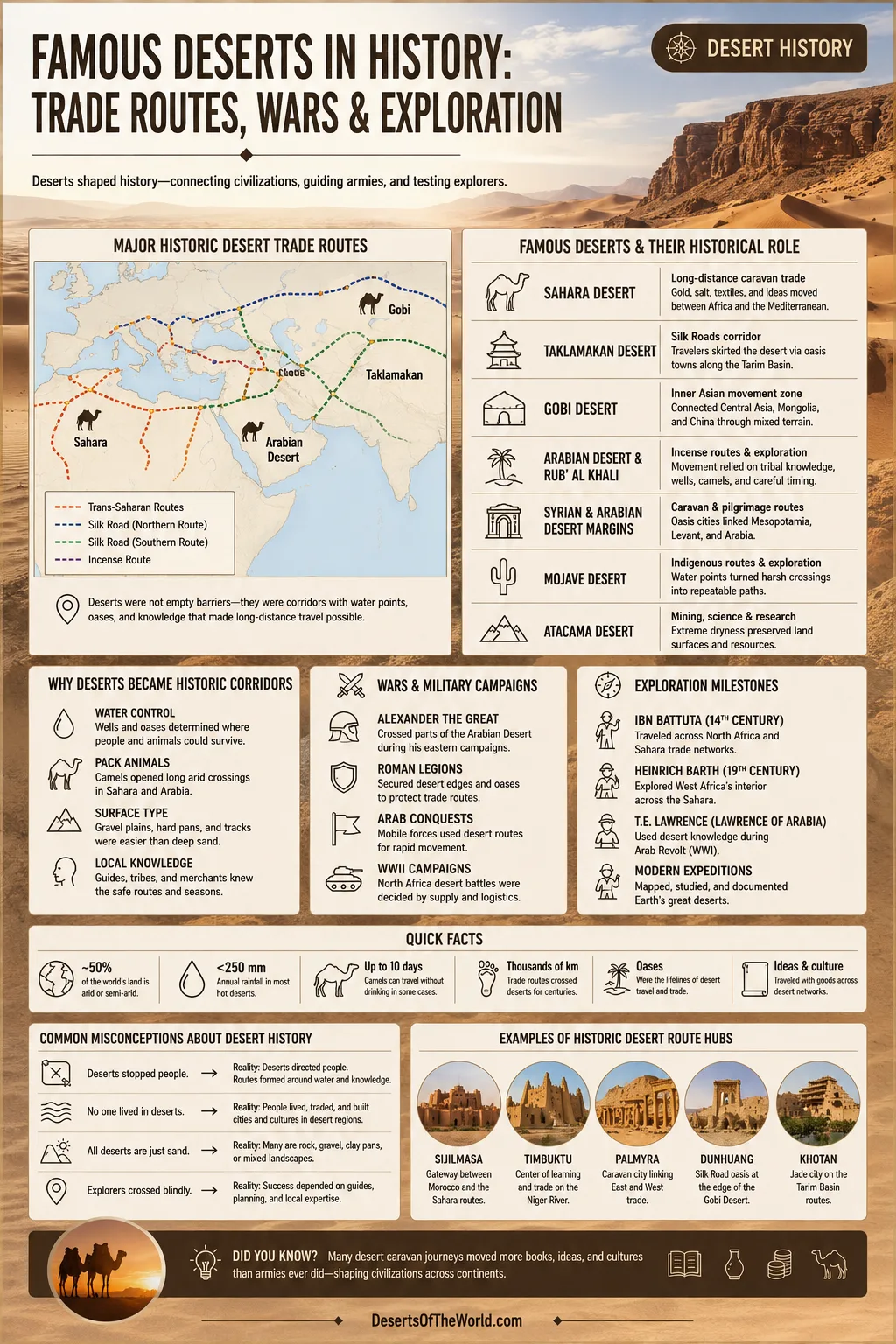
Famous Deserts In History: Main Roles
The most famous historic deserts did not shape history in the same way. Some carried trade. Some shaped exploration. Some affected wartime movement because water, fuel, animals, engines, and distance mattered more than open space. The table below gives the main pattern before the details begin.
| Desert Or Arid Region | Historical Role | Routes, Places, Or Themes | Why It Mattered |
|---|---|---|---|
| Sahara Desert | Long-distance caravan trade | Trans-Saharan routes, Sijilmasa, Tadmekka, Gao, Timbuktu, Fezzan | Linked North Africa, the Sahel, and Mediterranean markets through gold, salt, textiles, copper, and other goods. |
| Taklamakan Desert | Silk Roads corridor | Dunhuang, Turfan, Kucha, Khotan, Kashgar, Tarim Basin oases | Travelers usually skirted the desert rim instead of crossing its central sands. |
| Gobi Desert | Inner Asian movement zone | Steppe-desert corridors, caravan stations, wells, monasteries, Sogdian routes | Connected Central Asia, Mongolia, and northern China through a mix of desert, grassland, and mountain-edge travel. |
| Arabian Desert And Rub’ Al Khali | Incense routes, edge travel, exploration | Frankincense routes, Oman, Yemen, Najd, Empty Quarter crossings | Movement depended on tribal knowledge, wells, camels, seasonal timing, and careful route choice. |
| Syrian And Arabian Desert Margins | Caravan and pilgrimage movement | Palmyra, Damascus, desert-edge routes toward Mesopotamia and Arabia | Oasis towns and desert-edge cities became transfer points between settled lands and arid routes. |
| Mojave Desert | Indigenous routes, exploration, wagon roads | Mojave Road, Old Spanish Trail branch, Colorado River, Mojave River | Water points turned a harsh crossing into a repeatable route across the American Southwest. |
| Atacama Desert | Mining, science, and extreme-environment research | Northern Chile, Andean margins, nitrate zones, Mars-like soils | Its dryness preserved surfaces and made the desert a natural laboratory for geology, astronomy, and habitability studies. |
Why Deserts Became Historic Corridors
Deserts shaped movement because they compressed choices. In forest, valley, or grassland, travelers could often adjust direction. In a desert, routes narrowed toward water, shade, firm ground, and known landmarks. That is why wells, caravan towns, salt pans, mountain passes, and dry riverbeds became part of historic geography.
Four forces mattered most:
- Water control: Wells and oases decided where people could stop, rest animals, and continue.
- Pack animals: Camels made long arid crossings more practical in the Sahara and Arabia; horses, donkeys, mules, and oxen had narrower limits.
- Surface type: Gravel plains, hard pans, and desert tracks often worked better than soft dunes.
- Local knowledge: Guides, pastoral communities, oasis residents, and merchants knew when a route was usable and when it was unsafe.
This is why many famous desert routes did not run through the emptiest heart of a desert. They used the edges. Around the sand, not through it. Often, that was the smarter road.
The Sahara Desert And Trans-Saharan Trade
The Sahara is the best-known example of a desert that became a trading space. It is the largest hot desert on Earth and stretches across much of North Africa. Its size made it difficult, but its position made it impossible to ignore. North of it lay Mediterranean cities and markets. South of it lay the Sahel, the Niger River region, and major centers of West African trade and learning.
Trans-Saharan trade did not mean one simple line across the sand. It was a web of routes. Caravans moved through places such as Sijilmasa in Morocco, Taghaza and Tadmekka in the central Sahara, Gao and Timbuktu near the Niger River, and routes through the Fezzan and Ghadames zones. Some paths changed with political conditions, water availability, and market demand.
Goods That Crossed The Sahara
Salt is often the easiest product to understand. In many West African regions, salt was needed for diet, preservation, and livestock, while desert salt deposits could be mined and moved by caravan. Gold moved north from West African trading zones. Copper, glass beads, ceramics, leather, textiles, dates, books, and crafted goods also moved through the system.
The Sahara did not only carry goods. It carried scripts, styles, legal ideas, religious learning, scholarship, and artistic forms. Desert towns were not simply stopping points. They were places where merchants, scholars, guides, herders, and craftspeople met.
Why Camels Changed Saharan Movement
The camel did not make the Sahara easy. It made regular long-distance desert travel more workable. Camels could carry loads, endure heat, and travel between water points better than many other animals. They also needed skilled handlers. A caravan was a moving system: animals, goods, guides, water planning, route memory, and timing.
Caravan travel still carried risk. Sandstorms, heat, weak animals, poor navigation, and failed wells could break a journey. The most successful routes were not heroic straight lines. They were practical chains of known places.
The Taklamakan Desert And The Silk Roads
The Taklamakan Desert sits inside the Tarim Basin in what is now western China. Its name often appears in histories of the Silk Roads, but the most useful detail is this: travelers usually did not cross the middle of the Taklamakan. They moved around it.
Two broad route belts formed around the desert rim:
- The northern rim: linked places such as Turfan, Kucha, Aksu, and Kashgar.
- The southern rim: linked oasis towns such as Khotan, Niya, and routes toward the Pamir and Central Asia.
To the east, Dunhuang stood near the Gansu Corridor, a narrow route between mountains and desert. This made it one of the famous gateway places of the Silk Roads. To the west, Kashgar linked the Tarim Basin with routes toward Central Asia.
Why Oasis Towns Became Powerful
In the Tarim Basin, the desert forced travelers toward oasis settlements fed by mountain water. These towns offered food, animals, translators, storage, religious sites, workshops, and information about the road ahead. Their value came from geography. A town near reliable water could become a hinge between regions.
Silk gave the route its famous name, but silk was never the only cargo. Horses, jade, paper, spices, metalwork, manuscripts, medicines, dyes, glass, wool, and ideas moved along these paths. Monks, envoys, artisans, merchants, and interpreters all helped turn desert-edge travel into cultural contact.
The Taklamakan As An Archive
Deserts can preserve what wetter places destroy. Around the Taklamakan, dry conditions helped preserve manuscripts, textiles, wooden tablets, murals, and abandoned settlement remains. That makes the desert an archive as well as a route. History there is not only written in texts. It is also found in ruins, irrigation traces, burial sites, and objects left in dry ground.
The Gobi Desert And Inner Asian Routes
The Gobi is not one endless field of sand. Much of it is gravel, bare rock, dry basin, steppe, and mountain-edge country. That mixed landscape gave it a different role from the Sahara or Taklamakan. It connected northern China, Mongolia, and Central Asia through routes that depended on wells, pasture, seasonal movement, and knowledge of open terrain.
Sogdian merchants from Central Asia became famous for their role in Silk Roads exchange. Their routes linked cities such as Afrasiab near modern Samarkand with trade corridors reaching toward China. The journey across mountains, basins, and deserts could take months. It required languages, contacts, animals, storage, and safe stopping places.
Dunhuang, The Gansu Corridor, And The Desert Edge
Dunhuang sits near the meeting point of desert and corridor. It became known for Buddhist cave sites, manuscripts, and its place along routes between China and Central Asia. The Gobi and nearby arid lands made the Gansu Corridor valuable because it offered a more manageable passage between high mountains and dry basins.
The Gobi also reminds us that desert history is rarely clean and simple. Steppe, desert, oasis, and mountain zones overlap. A merchant might cross dry gravel one week, follow pasture the next, then enter a settled oasis city. The map changes under your feet.
The Arabian Desert, Incense Routes, And The Empty Quarter
The Arabian Desert covers a vast part of the Arabian Peninsula. Within it, the Rub’ al Khali, or Empty Quarter, is one of the largest sand deserts on Earth. Its dunes, salt flats, heat, and sparse settlement made direct travel hard. Many historic routes used the desert edges, uplands, coastal zones, and wells rather than the deepest sands.
Frankincense And Desert-Edge Trade
Southern Arabia became famous for frankincense and myrrh. These aromatic resins moved from production zones in the south toward markets in Arabia, the Mediterranean, and beyond. The routes were not only commercial paths. They helped connect ports, inland towns, oasis communities, and desert-edge settlements.
Here, the useful lesson is restraint. Stories about lost cities and buried caravan towns can be attractive, but desert history needs evidence: inscriptions, settlement remains, ancient roads, water systems, pottery, written records, and careful archaeology. The desert invites legends. Evidence keeps the story steady.
Exploration Of The Rub’ Al Khali
Modern exploration accounts of the Empty Quarter often mention travelers such as Bertram Thomas, Harry St John Philby, and Wilfred Thesiger. Their journeys became famous in English-language geography and travel writing. Yet their movement depended heavily on Bedouin guides, local route knowledge, camel handling, wells, and social trust. Without that knowledge, the map alone was thin paper.
This is one of the most missed points in desert exploration: the person who publishes the account is not always the person who made the journey possible. Desert travel has always been collective.
The Syrian Desert And Caravan Cities
The Syrian Desert and the arid margins between the Levant, Mesopotamia, and Arabia formed another historic movement zone. The desert did not work like a single highway. It worked through nodes: wells, caravan halts, river crossings, and oasis cities.
Palmyra is the best-known example of an oasis city tied to desert commerce. Its position helped connect Mediterranean and Mesopotamian trade zones. Caravans could not move freely everywhere, so places that offered water, security, storage, and market access became valuable.
Desert-edge cities often grew because they managed transition. They sat between settled farmland and open arid country. Goods changed hands. Animals were rested. Information moved. Travelers waited for the right season or joined larger groups.
The Mojave Desert, Old Trails, And Western Movement
The Mojave Desert in the American Southwest shows the same rule in a different landscape: water makes the route. Long before wagon roads, Indigenous communities used trail systems between the Colorado River and the California coast. These routes followed water sources, seasonal knowledge, and practical crossings.
The Mojave Road later became one of the best-known historic desert routes in the region. Much of it crosses what is now Mojave National Preserve. The route linked the Colorado River area with the Mojave River region and connected with wider travel systems, including branches related to the Old Spanish Trail.
Why The Mojave Road Matters
The Mojave Road is often discussed as a track, but it is better understood as a chain of water knowledge. Piute Springs, Rock Springs, Marl Springs, Soda Springs, and other points mattered because they made movement repeatable. In desert history, repeatability is everything. A route that can be used again becomes a corridor.
Explorers, surveyors, mail carriers, traders, migrants, and later recreational travelers all used versions of older paths. Yet the older pattern stayed visible: cross the desert by linking water to water.
The Atacama Desert And Scientific Exploration
The Atacama Desert in northern Chile is one of the driest non-polar deserts on Earth. It did not become famous mainly because of caravan trade. Its historic role is tied to mining, Andean routes, astronomy, geology, and the study of extreme environments.
In parts of the Atacama, very low rainfall and dry soils help preserve landforms for long periods. That dryness has made the desert useful for research into Mars-like conditions, microbial survival, meteorites, and the movement of tiny amounts of water through soil and air.
Here, exploration is not only about crossing. It is about reading a landscape. Salt flats, nitrate fields, high plateaus, fog zones, and clear skies all turned the Atacama into a place where Earth science and space science meet.
Deserts And Wartime Movement
Deserts have also shaped military history, but not because they are empty stages for drama. Their influence is more practical: water, fuel, distance, heat, dust, repair, maps, supply lines, and visibility. The desert does not need walls to control movement. It uses exposure.
The North African campaigns of the Second World War are often used as an example of desert logistics. Forces could move across wide areas, but every advance stretched supply. Fuel, water, spare parts, tires, food, and engine maintenance became as important as direction. Sand abrasion damaged vehicles. Rough ground slowed movement. Long supply lines became hard to protect and harder to maintain.
A desert campaign could shift quickly because the same open space that allowed movement also created weakness. Move too far, and supply thins. Pause too long, and heat, dust, and distance keep working against you.
What Deserts Change In Military Geography
| Desert Condition | Effect On Movement | Historic Response |
|---|---|---|
| Long distances between water | Limits speed and group size | Use wells, depots, convoys, or route planning around known water points. |
| Soft sand and dune fields | Slows animals, carts, and vehicles | Prefer gravel plains, hard pans, wadis, and desert margins when possible. |
| Heat and cold swings | Strains people, animals, and engines | Travel at suitable hours, rest in shade, carry water, and reduce load where needed. |
| Dust and sand abrasion | Damages equipment and reduces visibility | Use maintenance routines, filters, covered storage, and slower movement. |
| Few landmarks in open terrain | Raises navigation risk | Use guides, stars, compass bearings, mapped wells, ridgelines, and track memory. |
This kind of history can be studied safely as geography. It shows how terrain changes decisions. It does not need graphic detail to be useful.
Exploration: Local Knowledge Before Famous Names
Many desert exploration stories focus on named travelers. Ibn Battuta, Xuanzang, Aurel Stein, Wilfred Thesiger, Bertram Thomas, and others appear often in books and museum collections. Their accounts matter, but they should not erase the people who knew the land first.
Pastoral groups, oasis farmers, caravan guides, Indigenous communities, water finders, translators, and animal handlers made desert movement possible. In the Sahara, guides knew wells and seasonal grazing. Around the Taklamakan, oasis communities connected travelers to food, animals, and information. In the Mojave, older trail systems followed water across dry basins. In Arabia, Bedouin route knowledge shaped crossings that outsiders later described as exploration.
So the cleaner sentence is this: famous explorers often entered deserts through knowledge already held by local people.
Trade Routes Were Usually Networks, Not Single Roads
One mistake appears often in short desert histories: a route is shown as one neat line. Real routes were messier. They split, rejoined, paused, shifted, and sometimes disappeared for a season or a decade.
A route could change because of:
- a dry well or failed spring;
- sand covering a familiar track;
- a new market town growing nearby;
- a safer pass becoming available;
- a river crossing changing after flood or drought;
- the need to avoid the deepest dunes;
- fresh information from merchants arriving in the opposite direction.
That is why the phrase Silk Roads is often more accurate than Silk Road. The same idea works for the Sahara, Arabia, the Mojave, and many other deserts. History moved through networks.
How Desert Landscapes Controlled Historic Routes
Different desert surfaces created different route choices. A sand sea looks famous in photographs, but many travelers preferred firmer ground. Gravel plains, dry valleys, limestone plateaus, mountain foothills, and salt-flat edges could be easier than dune fields.
| Landscape Feature | What It Offered | Historic Example |
|---|---|---|
| Oasis | Water, crops, rest, storage, local markets | Dunhuang, Khotan, Palmyra, Siwa, Ghadames |
| Wadi Or Dry Riverbed | Natural corridor, occasional water, easier navigation | Arabian and Saharan desert-edge routes |
| Gravel Plain | Firmer travel surface than dunes | Sahara regs and Gobi gravel zones |
| Mountain Pass | Gateway between basins and trade zones | Pamir approaches near western Silk Roads |
| Salt Flat | Resource zone, landmark, sometimes difficult ground | Saharan salt areas and Atacama salars |
| River Edge | Food, settlement, transport link, route start or finish | Niger River towns, Colorado River crossings, Nile desert margins |
Famous Desert Route Entities To Know
Several names appear again and again in desert history. Knowing them makes the subject easier to follow.
Sahara And Sahel
- Sijilmasa: A major Moroccan trade center linked to Saharan routes.
- Tadmekka: A Saharan trading town in present-day Mali, tied to medieval exchange.
- Gao: A Niger River city connected to Saharan commerce.
- Timbuktu: A center of trade and learning near the desert edge.
- Taghaza: Known for Saharan salt mining and caravan trade.
- Fezzan: A Libyan desert region with long route history.
Silk Roads And Inner Asia
- Dunhuang: A desert-edge gateway near the Gansu Corridor.
- Turfan: An oasis zone on northern Silk Roads routes.
- Kucha: A northern Tarim Basin oasis town tied to Buddhist and commercial exchange.
- Khotan: A southern Tarim Basin oasis known for jade and Silk Roads links.
- Kashgar: A western gateway between the Tarim Basin and Central Asia.
- Sogdians: Central Asian merchants known for long-distance trade across Silk Roads networks.
Arabia And Desert Exploration
- Rub’ al Khali: The Empty Quarter, a vast sand desert in the southern Arabian Peninsula.
- Frankincense routes: Trade paths connected to resin-producing areas of southern Arabia.
- Oman and Yemen: Important regions in incense history and Arabian desert-edge movement.
- Bedouin guides: Essential holders of route, water, and seasonal knowledge.
North American Desert Routes
- Mojave Road: A historic east-west desert route across Mojave National Preserve.
- Old Spanish Trail: A wider historic trail system connected to desert passages in the American Southwest.
- Colorado River: A major water boundary and route marker for Mojave crossings.
- Mojave River: A desert watercourse that helped shape travel in the region.
Common Misunderstandings About Deserts In History
“Deserts Were Empty”
Many deserts were thinly populated, but not empty. Nomadic pastoralists, oasis farmers, miners, traders, pilgrims, messengers, and guides lived with desert rhythms. Some places were seasonal. Some were permanent. Some were abandoned and later reused.
“Caravans Crossed Straight Through The Sand”
Sometimes they crossed open desert, but many routes bent toward wells, firm ground, and safer passages. The shortest line was not always the real route. In a desert, a longer path with water can be faster than a shorter path without it.
“Explorers Discovered Desert Routes Alone”
Most famous desert journeys depended on local people. Guides, translators, camel handlers, pastoral communities, and oasis residents supplied the knowledge that made movement possible.
“The Silk Road Was One Road”
It was a network. Branches moved around deserts, across mountains, through oases, and toward ports. Goods and ideas often changed hands many times before reaching a final market.
Frequently Asked Questions
Which Desert Was Most Famous For Trade Routes?
The Sahara is the clearest example for desert caravan trade, especially through trans-Saharan routes linking North Africa with the Sahel and West African trading centers. The Taklamakan and Gobi are also strongly tied to Silk Roads exchange across Inner Asia.
Did The Silk Roads Cross The Taklamakan Desert?
Most routes avoided the central Taklamakan and followed oasis belts around its northern and southern edges. This made towns such as Dunhuang, Turfan, Kucha, Khotan, and Kashgar valuable.
Why Were Oases So Important?
Oases supplied water, food, shade, animals, storage, and information. In desert travel, an oasis could turn isolated movement into a repeatable route.
How Did Deserts Affect Wars?
Deserts affected wartime movement through logistics. Water, fuel, repair, heat, dust, visibility, and distance could decide what movement was possible. The most useful way to study this topic is through terrain and supply, not graphic events.
Were Deserts Barriers Or Bridges?
They were both. A desert blocked casual movement but rewarded people who knew its routes. That is why deserts often became controlled corridors rather than empty gaps.
Sources
- National Geographic Education — The Silk Road (Silk Roads as a network of routes and long-distance exchange)
- UNESCO — The Silk Roads Programme (cultural, commercial, and scientific exchange along Silk Roads networks)
- Northwestern University Libraries — Caravans Of Gold, Fragments In Time (Saharan trade, goods, and medieval exchange networks)
- Smithsonian — Historical Trade Routes Of The Sogdians (Sogdian merchants and Central Asian routes toward China)
- National Army Museum — The Struggle For North Africa, 1940–43 (desert logistics, supply lines, fuel, and vehicle wear)
- U.S. National Park Service — Mojave Road (route length, terrain, and Mojave National Preserve crossing)
- U.S. National Park Service — The Mojave Road And The Old Spanish Trail (historic route development and older trail systems)
- Pitt Rivers Museum, University Of Oxford — Thesiger’s Journeys In Arabia (Empty Quarter exploration context)
- Arizona State University — Tracking Water In The Atacama Desert (Atacama dryness, water movement, and Mars-related research)
- Encyclopaedia Britannica — Sahara (Sahara geography, scale, and physical features)