A rain shadow desert forms when mountains strip moisture from moving air, leaving the leeward side much drier than the windward side. That sounds simple. The land itself is not simple at all. Some rain shadow deserts are cold, some are hot, some look like dune seas, and some are mostly gravel, bare rock, clay flats, and dry basins. The common thread is the same: air rises, cools, drops moisture, then descends warmer and drier on the far side.
Patagonian Desert
Location & Continent Continent: South America Countries: Mainly Argentina, with smaller steppe areas extending into Chilean Patagonia Region:...
Read More →Monte Desert
Location & Continent Continent: South America Country: Argentina Region: Eastern foothills of the Andes, from northern–central Argentina to...
Read More →Mojave Basin and Range
Location & Continent Continent: North America Country: United States (California, Nevada, Arizona, Utah) Coordinates: 35°N, 115°W Mojave Desert...
Read More →Central Basin and Range (Great Basin Desert)
Location & Continent Continent: North America Country: United States (Nevada, Utah, California, Oregon, Idaho) Coordinates: ~39.5°N, 116°W (regional...
Read More →Taklamakan Desert
An immense sea of sand in China’s Xinjiang Uyghur Autonomous Region, the Taklamakan is one of Earth’s largest...
Read More →Karakum Desert
Location & Continent Continent: Asia Countries: Turkmenistan (mainly), with smaller portions extending into Uzbekistan and Kazakhstan Coordinates: 39°N,...
Read More →Kyzyl Kum
Location & Continent Continent: Asia Countries: Uzbekistan, Kazakhstan, Turkmenistan Coordinates: 41°N, 64°E Kyzyl Kum – Map & Street...
Read More →Gobi Desert
Location & Continent Continent: Asia Countries: China, Mongolia Coordinates: 42°N, 105°E Gobi Desert – Map & Street View...
Read More →Thal Desert
Location & Continent Continent: Asia Country: Pakistan (Punjab Province – between the Jhelum and Indus Rivers; districts including...
Read More →Kharan Desert
Location & Continent Continent: Asia Country: Pakistan (Balochistan Province) Coordinates: near Kharan town ≈ 28°35′N, 65°25′E Physical Features...
Read More →Indus Valley Desert
Location & Continent Continent: Asia Country: Pakistan Province: Punjab Coordinates: 31.250°N, 71.667°E Physical Features Area: 19,501 km² (WWF...
Read More →Katpana Desert
Location & Continent Continent: Asia Country / Region: Pakistan — Gilgit-Baltistan (Skardu District) Coordinates: 35.3105°N, 75.5907°E Katpana Desert...
Read More →12 inventions in Rain Shadow Deserts
Across the world, mountain-made drylands appear beside the Andes, the Sierra Nevada, the Tien Shan, the Kunlun, the Altai, the Kopet Dag, the Salt Range, and the high walls of the Karakoram and Himalaya. On maps they can look disconnected. In climate terms, they belong to one family. That family includes the Patagonian Desert, Monte Desert, Mojave Basin and Range, Central Basin and Range, Taklamakan Desert, Karakum Desert, Kyzyl Kum, Gobi Desert, Thal Desert, Kharan Desert, Indus Valley Desert, and Katpana Desert.
These landscapes matter because they do more than stay dry. They steer rivers, shape dust transport, limit tree cover, change soil chemistry, and produce some of the sharpest ecological transitions on Earth. In many places, a mountain crest, a piedmont, a basin floor, and a salt flat sit within a short distance of each other. The shift can feel abrupt. Wet slope. Dry lee. Closed basin. Windworked plain.
The core idea: a rain shadow is not just “less rain behind a mountain.” It is a chain reaction involving orographic lift, condensation, leeward descent, adiabatic warming, high evaporation, and very often interior drainage. That chain reaction explains why many of these deserts hold playas, salars, dry washes, alluvial fans, dune fields, and sparse shrub steppe rather than large permanent rivers crossing the whole basin.
How Mountains Build Dry Country
Moist air moving inland does not glide through a mountain wall. It is forced upward. As it rises, it cools. Cooling makes condensation easier, clouds thicken, and rain or snow falls on the windward slopes. By the time that air crosses the crest and descends on the leeward side, much of its moisture is gone. The descending air compresses and warms, which lowers relative humidity and makes fresh cloud formation harder. So the land beyond the range receives far less precipitation.
That is the classic orographic rain shadow. Yet the real world adds layers. One range may wring out Pacific moisture, then a second range may block what remains, and a high plateau may drain the rest. Some deserts sit in a single clear shadow. Others sit in a stacked shadow, where several mountain systems and a long inland journey combine to dry the air even more.
Season matters too. In mid-latitude deserts, winter westerlies often deliver the little moisture that does arrive. In South Asia, the monsoon may reach the outer mountains but lose force before crossing inner ranges and valleys. In high interior Asia, the distance from oceanic moisture is already large, so mountains do not work alone; they work with continentality. The air starts dry and gets drier.
Topography then takes over. Water that falls on the mountains often runs into enclosed basins rather than escaping to the sea. That creates endorheic drainage: streams fade into gravel fans, marshy margins, salt flats, or shallow terminal lakes. In the Great Basin and the Tarim Basin, this pattern is not a side note. It is the skeleton of the landscape.
- Windward Slope: rising air, cooling, cloud growth, more rain or snow.
- Crest and Passes: moisture loss, snow storage, seasonal meltwater.
- Leeward Slope: descending air, warming, lower humidity.
- Piedmont and Basin: alluvial fans, ephemeral washes, saline flats, dune accumulation.
- Long-Term Result: sparse vegetation, strong thermal ranges, and soils with limited organic matter.
That is why one rain shadow desert can be full of thorn scrub while another is a cold stony steppe, and another is a huge sand sea. Same process. Different elevation, latitude, moisture source, and geology.
Why Rain Shadow Deserts Do Not All Look Alike
A desert made by mountain blocking can still be hot, cold, sandy, gravelly, or mostly bedrock and clay. Latitude controls solar intensity. Elevation controls temperature. Basin shape controls where sediment settles. Distance from the sea controls how much moisture remains before the air even reaches the first ridge.
The Mojave and Death Valley show how fierce heat can become when dry descending air meets low elevations, open skies, and high evaporation. The Great Basin shows a different face: high desert, cold winters, snow-fed ranges, and many valleys that still count as arid because yearly precipitation often stays below desert thresholds. Patagonia takes another route. It sits east of the Andes, in the path of moisture-stripped westerlies, and broad plateaus help create a cold, windy steppe desert. Asia goes larger still: the Taklamakan is ringed by high mountains, the Gobi mixes cold-desert and semidesert surfaces, and the Karakum and Kyzyl Kum sit in a dry continental interior shaped by both relief and distance from the ocean.
Some listed deserts are textbook rain shadow systems. Others are mixed-origin drylands, where mountain barriers, continental interior position, and seasonal wind systems all matter. That distinction is worth keeping. It makes the map clearer, not messier.
| Desert | Main Mountain Influence | Approximate Area | Typical Moisture Pattern | Surface Character |
|---|---|---|---|---|
| Patagonian Desert | Andes block Pacific westerlies | About 673,000 km² | Often around 125–200 mm in central dry tracts | Plateaus, gravel plains, shrub steppe |
| Monte Desert | Eastern Andes foothill shadow | About 467,000 km² | Usually under 100–450 mm | Piedmonts, plains, thorn scrub, dunes in places |
| Mojave Basin and Range | Sierra Nevada plus southern California ranges | About 65,000 km² | Roughly 34–310 mm, with a long-term regional average near 137 mm | Basin floors, mountain blocks, playas, dunes |
| Central Basin and Range | Sierra Nevada and adjacent western ranges | Part of the 492,000 km² Great Basin region | Many basins near 100–300 mm, mostly snow-fed margins | Cold desert valleys, sagebrush, salt flats |
| Taklamakan Desert | Encircled by Tien Shan, Kunlun, Pamir margins | About 320,000 km² | Only about 10–38 mm across much of the desert | Huge sand sea, dune fields, dry river corridors |
| Karakum Desert | Kopet Dag barrier plus interior continental drying | About 350,000 km² | Often around 70–150 mm | Sands, takyrs, sparse shrub cover |
| Kyzyl Kum | Interior shadowing and regional upland barriers | About 300,000 km² | Often around 100–200 mm | Sand ridges, basins, low isolated hills |
| Gobi Desert | Tibetan-Himalayan and Central Asian mountain barriers | About 1,300,000 km² | About 50–200 mm, with strong local contrasts | Rocky plains, gravel, steppe, some dunes |
| Thal Desert | Regional shielding by the Salt Range and nearby uplands | About 23,000 km² | Often around 150–350 mm, highly erratic | Sandy dunes, interdunal tracts, alluvium |
| Kharan Desert | Interior Balochistan shadowing by surrounding highlands | About 48,000 km² | Often around 50–125 mm | Sand, gravel, rocky surfaces, dry basins |
| Indus Valley Desert | Reduced rain east of western uplands, strong evaporation | About 19,500 km² | Rain can be higher than in classic hyper-arid deserts, yet water loss stays very high | Alluvial plains, scrub, sandy patches |
| Katpana Desert | Inner mountain rain shadow in the Karakoram-Himalaya region | Mapped dune field around 9.4 km² | Low precipitation around Skardu, with cold winters and occasional snow on dunes | High-altitude sand, gravel, snow-dusted dunes |
South America: The Andes and the Long Dry Lee
Patagonian Desert
The Patagonian Desert is one of the clearest rain shadow stories on the planet. The Andes intercept moisture carried by the Southern Hemisphere westerlies. West of the range, air rises and dumps rain and snow. East of the crest, the atmosphere descends far drier, and southern Argentina opens into a wide belt of steppe and desert. The result is a huge arid zone of about 673,000 km², making it the largest desert in the Americas.
Patagonia is not a dune ocean in the usual popular-image sense. Much of it is a cold, windy plateau country with gravel mantles, low shrubs, broad tablelands, escarpments, and river-cut valleys. Annual precipitation in many central dry areas falls into the rough 125 to 200 mm range, while nearby Andean sectors can receive many times more. That contrast is the clue. Look west to east and the climate line becomes easy to read.
Wind is part of the identity here. Strong, persistent airflow strips fine sediment, moves dust, and makes the surface feel even drier than rainfall numbers alone suggest. Patagonia is also a notable dust source for the South Atlantic. So the desert is not just a passive rain-shadow recipient; it feeds back into wider environmental systems through sediment export, soil loss, and marine nutrient input.
The Patagonian Steppe shows another point that many short explainers miss: rain shadow deserts do not need intense heat to qualify as deserts. Patagonia can stay cool for much of the year. Frost is common. Snow can occur. Aridity still rules because precipitation remains low, evapotranspiration can be high in windy periods, and the vegetation cover stays sparse enough to leave the ground exposed.
Its landforms reflect long-term dryness. Gravel pavements, basaltic plateaus, dry valleys, and broad alluvial surfaces dominate many tracts. Vegetation leans toward bunchgrasses and shrubs adapted to cold, desiccating winds. It looks austere, but not empty. Guanacos, foxes, steppe birds, and hardy shrubs all fit the same climate logic. Water is precious, patchy, and tied closely to snowmelt rivers and local groundwater.
Monte Desert
North of much of Patagonia lies the Monte Desert, an Argentine dryland running along the eastern Andes and their foothill systems. The Monte is often overshadowed by better-known deserts, though it deserves more attention in any serious page on mountain-created aridity. It occupies about 467,000 km² and works as a broad transition between the high Andes, the more famous Atacama to the northwest, and the Patagonian drylands to the south.
The Monte does not rely on one dramatic wall of mountains alone. Instead, Andean uplift, foothill relief, and interior basin geometry together create a dry belt. Mean annual rainfall can range from under 100 mm in the driest parts to around 450 mm in less arid sectors. That wide spread matters. The Monte is a desert biome, yet it contains internal variety tied to latitude, elevation, and piedmont position.
Vegetation gives the Monte its own signature. Jarilla shrublands, thorny scrub, and open woody patches where groundwater is reachable are more typical here than the colder steppe look of Patagonia. This is still a rain-shadow landscape, but one with a warmer tone, more summer rainfall in many sectors, and stronger shrub dominance. In places, alluvial fans and dry channels radiate from mountain fronts like giant sediment aprons.
That piedmont architecture is classic desert geomorphology. Uplands shed coarse sediment during rare high-energy flows. Fans spread outward, channels braid and vanish, and basin floors accumulate finer material. Dryness keeps chemical weathering slow, while flash floods do short, forceful bursts of work. It is not a gentle landscape. It just hides its energy between storms.
Putting Patagonia and the Monte side by side helps clarify a basic truth: the Andes cast more than one kind of shadow. In the south, the lee becomes a cold, windy steppe desert. Farther north and along the foothills, the dry belt shifts toward shrub desert and semiarid basins. One mountain chain, several desert expressions.
North America: Basin-and-Range Drylands Behind Pacific Barriers
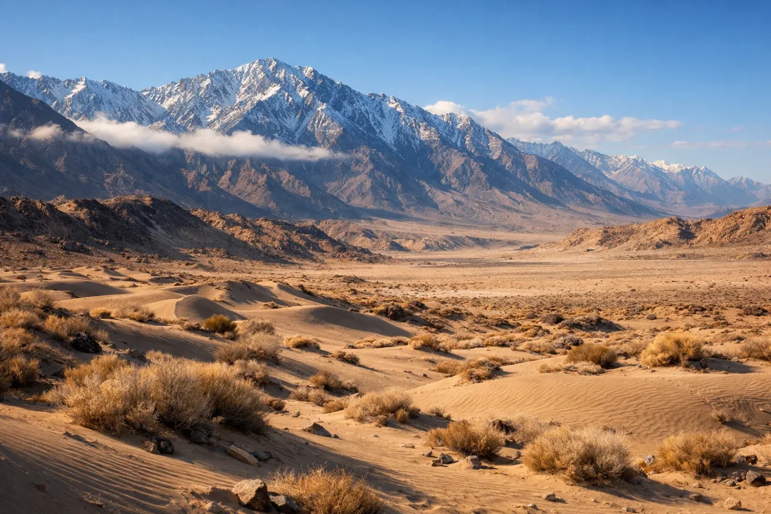
Mojave Basin and Range
The Mojave is often introduced through extremes, and for good reason. It contains Death Valley, the lowest point in North America, and some of the hottest air temperatures ever measured on Earth. Yet the Mojave is not just a heat headline. It is a rain shadow desert built by western mountain barriers, especially the Sierra Nevada and parts of the Transverse and Peninsular ranges of southern California.
The regional desert area is about 65,000 km². Average annual precipitation across Mojave stations has been estimated near 137 mm, though local totals range widely by elevation, from roughly 34 mm in the driest low zones to over 300 mm in wetter uplands. Mojave National Preserve itself often sees about 3.5 inches of rain at lower elevations and close to 10 inches in the mountains. In the Death Valley sector, average yearly rainfall drops below 2 inches.
Those figures make sense when the topography is read correctly. Pacific storms arrive from the west. The wettest moisture falls on mountains first. Leeward valleys get the leftovers. Then elevation amplifies the difference once more: mountain islands receive more snow and rain, while basin floors bake, dry out, and salt up. The surface becomes a mosaic of bajadas, playas, dune fields, volcanic hills, and internal basins.
The phrase Basin and Range is not decorative here. It describes parallel mountain blocks separated by wide structural basins. In desert climate, that pattern matters enormously. Mountains catch what little moisture arrives. Fans spread coarse sediment onto basin margins. Finer clays and salts accumulate lower down. Rare storm runoff may cross the floor, pond briefly, then vanish through evaporation or infiltration. Days later, the channels can look dead again. They are not dead. They are waiting.
Mojave vegetation is sparse but sharply zoned. Creosote bush, Joshua tree in suitable belts, cacti in drier and warmer positions, and ephemeral wildflowers after wet winters all reflect tiny shifts in slope, soil, and water balance. That fine-grained patchiness is one of the best lessons a rain shadow desert can teach. Even within severe aridity, microtopography writes ecological boundaries.
The Mojave also shows why “rain shadow” should never be reduced to rainfall totals alone. Solar loading, low humidity, bare ground, and downslope warming all intensify aridity. So does salinity in basin bottoms. So does wind. Put that mix together and the desert becomes far more than a place with little rain. It becomes a land system built to hold water only briefly.
Central Basin and Range
The Central Basin and Range, often treated as part of the wider Great Basin Desert, is a colder and generally higher desert world than the Mojave. Its parent climate story is still leeward drying. The Sierra Nevada blocks much Pacific moisture, casting a broad shadow over an interior region of about 492,000 km². Many basin floors receive roughly 150 to 300 mm of precipitation a year, and some valley bottoms average near 100 mm.
What makes this region special is the mix of desert dryness and winter snow. Great Basin National Park describes the Great Basin as the only cold desert among the four major U.S. deserts, and that label fits. Moisture often arrives in cool-season systems. Snow piles up on ranges, then melts into springs, seeps, and short-lived streams. The valleys stay arid nonetheless because totals remain low and enclosed drainage prevents large outflowing river networks from organizing the whole region.
That closed-basin structure explains the region’s salt flats and playas. Water reaches the low points, spreads, evaporates, and leaves dissolved minerals behind. The famous Great Salt Lake lies within this interior-drainage logic, though many smaller flats and dry lakes across Nevada and Utah show the same principle on a quieter scale. A rain shadow can create dryness; an enclosed basin can preserve it in visible form.
The vegetation is also different from hotter deserts. Sagebrush, saltbush, greasewood, and bunchgrasses dominate huge areas, while pinyon-juniper woodlands climb some slopes. Soils often contain caliche or other cemented horizons that slow infiltration and root penetration. Surface crusts can be fragile. Break them, and wind erosion picks up fast. Leave them intact, and they help hold a thin ecological balance together.
In a broader mountain-created aridity story, the Central Basin and Range fills an important gap that popular summaries often skip. Not every rain shadow desert is about sand seas or furnace-like basins. Some are broad cold high deserts where snow, playa chemistry, sagebrush ecology, and endorheic drainage tell the real story.
Central and East Asia: Giant Interior Basins in Stacked Rain Shadows
Taklamakan Desert
The Taklamakan is one of the world’s most striking examples of a mountain-ringed desert. It fills most of the Tarim Basin in Xinjiang and spans roughly 320,000 km². Around it rise the Tien Shan to the north, the Kunlun to the south, and high western mountain connections toward the Pamir. That enclosure is a climatic gatekeeper. Moisture has a hard time reaching the basin interior, and the small amount that does arrive often falls near the margins rather than the center.
Annual precipitation across much of the desert is exceptionally low, often around 10 to 38 mm. That is true hyper-aridity. About 85% of the surface consists of shifting sand dunes, which makes the Taklamakan more than merely dry; it is one of Earth’s great sand seas. Dunes, interdunal corridors, old river courses, and marginal oases give it a pattern that is both harsh and surprisingly structured.
Snow and glacier melt from the surrounding mountains keep the basin alive at the edges. Rivers such as the Hotan, Yarkand, and Aksu descend from high terrain, carry sediment outward, and lose flow as they spread into lower, hotter ground. Some rivers once penetrated deeper into the basin than they do now. Others fade into alluvial fans or inland water bodies. So the Taklamakan is not cut off from mountains; it depends on them. They starve it of atmospheric moisture but feed it with meltwater along the rim. Dry center, watered margins. That tension defines the desert.
The basin geometry also traps heat and dust. Fine particles can stay mobile for long periods, and strong winds move sand into immense dune trains. At the same time, the surrounding highlands create a stark elevational frame: snow peaks above, moving sand below. Few desert scenes display relief contrast this clearly. Few feel so enclosed, either.
For a pillar page about mountain-created aridity, the Taklamakan adds an essential lesson: rain shadow deserts can become basin empires. Once several mountain walls combine with interior drainage and scarce incoming moisture, the resulting desert can grow far beyond the lee slope itself and occupy an entire structural depression.
Karakum Desert
The Karakum stretches across much of Turkmenistan and covers about 350,000 km². It is not boxed in as dramatically as the Taklamakan, but mountain influence still matters. The Kopet Dag along the south helps block moisture, while the desert’s position deep inside Central Asia means that whatever damp air survives the trip inland is already depleted. This is one of those stacked-shadow deserts: mountain blocking plus deep continentality, working together.
Average yearly rainfall often falls between 70 and 150 mm, with much of it arriving in winter and early spring. Summer is hot, dry, and strongly evaporative. The landscape includes sand sheets, dune fields, takyrs (hard clay pans), and sparse shrubs able to cope with both salinity and drought. Groundwater is locally important, but the broader surface system remains moisture-limited.
The Karakum also helps correct a common oversimplification. A rain shadow desert does not always sit directly behind one famous mountain wall. Some lie in a regional dryness corridor, where several uplands, long transport distance from the sea, and seasonal circulation patterns all help reduce precipitation. In the Karakum, the mountains matter, but so does the vast Eurasian interior.
Geomorphically, the Karakum is a study in sediment spread and stabilization. Some dune fields are active; others are partly fixed by hardy vegetation. Clay pans mark settings where fine sediment settles after rare ponding and then dries into hard cracked surfaces. These textures matter for travel, ecology, and even local dust behavior. Sand is only part of the story.
Kyzyl Kum
The Kyzyl Kum lies between the Amu Darya and Syr Darya and covers about 300,000 km². Annual precipitation generally falls near 100 to 200 mm, mainly in winter and spring. Like the Karakum, it is a dry interior desert influenced by both regional upland barriers and long overland distance from marine moisture sources. It belongs in a rain-shadow discussion not because one ridge alone creates it, but because mountain systems around Central Asia help wring out the air before it reaches this core interior space.
The Kyzyl Kum is less famous globally than the Gobi or Taklamakan, yet it is one of the best examples of how aridity can persist in a broad lowland between major rivers. Large rivers pass by or along the margins, but the desert itself remains dry because their water does not translate into widespread humid conditions across the surrounding terrain. River presence and desert climate can coexist. That catches many readers off guard.
Its surface includes sandy ridges, enclosed depressions, low mountains, and plains with patchy shrub cover. Subsurface moisture and localized groundwater help support grazing in certain sectors, while elsewhere the land stays open and stark. Again, the lesson is subtle but important: rain shadow deserts are not always empty of water sources; they are landscapes where water is geographically narrow and climatically outmatched.
In a continental comparison, the Kyzyl Kum shows a middle position between the hyper-arid sand sea of the Taklamakan and the colder, rockier expanses of the Gobi. It is arid, yes, but not uniform. The desert breathes through seasons, river corridors, and patchy groundwater windows.
Gobi Desert
The Gobi is vast, roughly 1.3 million km², and unlike the classic picture-book dune sea, much of it is rocky or gravelly rather than sandy. That alone makes it a very useful desert to study. Climatically, the Gobi sits within the broader rain shadow of the Himalayan-Tibetan highlands and other Central Asian mountain systems. It is also intensely continental. Those two controls combine to produce a cold desert and semidesert region with an annual precipitation range that can run from under 50 mm in the west to over 200 mm in the northeast.
Temperature range in the Gobi is famous for a reason. Average winter lows can reach about -40°C, while summer highs in some sectors can climb to about 45°C. That spread is a reminder that dry air and open skies permit big temperature swings. Without much atmospheric moisture to buffer heating and cooling, the land loses heat fast at night and gains it fast under sunlit conditions.
The Gobi is often described as if the Himalaya alone created it. The reality is a bit more layered. The Tibetan Plateau and Himalayan barrier block major moisture pathways from the Indian Ocean, while the long inland position of Mongolia and northern China deepens the deficit. The Altai, Hangayn, Qilian, and related uplands help shape local precipitation patterns too. So, yes, the Gobi belongs in a rain-shadow family, but it is a large regional dry system, not a simple narrow lee belt.
Its ecology matches the surface. Shrub-steppe, sparse grasses, saxaul in suitable sectors, cold-tolerant reptiles, ungulates, and hardy birds all reflect a land where rainfall is low but not absent and where winter can be severe. Dune fields occur, though broad stone and gravel surfaces may define the visual experience more strongly than sand. That matters for SEO and for accuracy. Many readers search “desert” and expect dunes; the Gobi teaches them that rock deserts and stony deserts are just as real.
Together, the Taklamakan, Karakum, Kyzyl Kum, and Gobi show four different Asian expressions of mountain-linked aridity. One is a nearly enclosed sand sea. Two are interior lowland deserts shaped by regional barriers. One is a huge cold rocky desert. Same family. Different faces.
Pakistan and Nearby Inner-Mountain Drylands: Where Aridity Mixes with Alluvium and High Relief
Thal Desert
The Thal Desert in Punjab covers about 23,000 km² and stretches for roughly 310 km. It lies between the Indus system and associated plains, with the Salt Range and nearby uplands helping reduce and redirect moisture pathways. Rainfall is not as low as in the Taklamakan or central Kharan, but it is erratic, often around 150 to 350 mm, and evaporation is strong enough to keep the landscape sandy and drought-prone.
Thal is important because it broadens the user’s picture of what a rain-shadow-linked desert can be. This is not an isolated hyper-arid basin. It is a sandy alluvial dryland tied to river systems, monsoon weakness, and regional topographic shielding. The sand itself tells a story too. Sediment studies show that Thal dunes preserve material linked to the Indus system and western Himalayan sources, meaning the desert is both a climatic and a sedimentary archive.
The landscape consists of dune ridges, interdunal depressions, sandy plains, and cultivated pockets where water access improves conditions. Vegetation can look fuller after rain, then thin out quickly as heat and wind take over. The desert does not stay visually static. It pulses with season and water availability.
That variability is exactly why Thal belongs in a larger rain shadow pillar page. Many online overviews focus only on extremely dry deserts and miss transitional arid regions where topography still shapes moisture, but not in a clean all-or-nothing way. Thal shows the in-between zone. Dry, sandy, leeward-influenced, yet still tied to monsoon margins and riverine geography.
Kharan Desert
Kharan, in western Balochistan, is drier and more severe. District-scale figures place the area near 48,000 km², and rainfall commonly sits in the broad 50 to 125 mm range, with some nearby sectors dropping even lower. Surrounded by uplands of the Iranian Plateau and interior Balochistan, Kharan lies in a region where both topographic shielding and distance from major moisture sources restrict rainfall sharply.
This is a classic interior desert setting of sand, gravel, rocky surfaces, dry basins, and sparse scrub. Storms are infrequent, but when they do arrive they can trigger powerful short-lived flows and erosion. The surface often looks still. It is not still for long after a rare event. Drylands work in bursts.
Kharan also helps explain why average rainfall alone can mislead readers. Two deserts may post similar totals on paper, yet one may behave as a much harder desert because evaporation, soil texture, runoff style, and groundwater access differ. In Kharan, the dryness is compounded by heat, exposure, low population density, and broad bare surfaces that do little to hold moisture after rain. Water leaves fast. The land remembers dryness longer than it remembers the storm.
From a rain-shadow angle, Kharan sits in a mountain-screened interior where precipitation gets filtered out before it reaches the basin. The air masses that do arrive are not only weak in moisture; they often arrive over terrain built to lose water quickly. That combination gives Kharan its severe desert character.
Indus Valley Desert
The Indus Valley Desert covers about 19,500 km² in northwestern Punjab between the Indus and Chenab rivers. At first glance, some readers may wonder how a desert can exist in a great river valley. The answer is simple once climate and hydrology are separated. A river corridor can transport huge amounts of water through a region that still has a dry local climate.
This desert is less about extreme rainfall scarcity alone and more about water deficit. Parts of the region may receive more rain than a hyper-arid desert, yet summer heat often exceeds 45°C, evaporation is intense, and vegetation remains sparse outside favored patches. Western uplands and regional relief help reduce rainfall, while the broader Indus plain atmosphere can stay hot and moisture-stressed for long periods.
That makes the Indus Valley Desert a very useful case study for searchers who assume desert means almost no rain everywhere. Not quite. Some deserts are defined by the balance between incoming moisture and outgoing water loss. Here, alluvial surfaces, sandy tracts, scrublands, and river-adjacent contrasts show how climate dryness and fluvial geography can share the same map.
It is also a reminder that rain-shadow influence can operate at regional scale. The desert does not sit behind a single dramatic alpine wall in the way Patagonia sits behind the Andes. Instead, reduced rainfall east of western uplands, strong seasonality, and very high evaporative demand keep the land arid enough to behave like a desert system. That nuance matters. It keeps the classification honest.
Katpana Desert
Katpana may be the most visually surprising desert in this whole comparison. Near Skardu in Gilgit-Baltistan, it sits at around 2,226 m above sea level, and detailed mapping has placed the main dune field near 9.4 km². This is a high-altitude cold desert, formed in an inner-mountain setting where the greater Himalayan-Karakoram relief blocks much monsoonal moisture before it can reach the valley.
That is why sand dunes here can appear with snow. The image looks unusual only if desert is equated with heat. In climate terms, Katpana is easy to understand: low precipitation, sharp temperature swings, high-elevation air, sparse vegetation, and strong sheltering by surrounding ranges. The valley sits in a rain shadow. The desert follows.
Katpana is smaller than the giants on this list, but it is one of the most instructive. It shows what happens when aeolian sand accumulation enters a cold mountain basin rather than a subtropical lowland. Dunes develop, yet the thermal regime is utterly different from the Mojave or Kharan. Winter freezes are normal. Snowfall can settle directly on sand. Summer remains dry, bright, and wind-shaped.
High-altitude desert settings also sharpen the role of local sediment supply. Valleys, glacial outwash, braided channels, and mountain-front deposits can all feed sand into the basin floor. Once sparse vegetation and dry winds take over, dune fields emerge. In that sense, Katpana is a meeting point of cryosphere, river sediment, and desert wind. A rare combo, and a very telling one.
Landforms That Keep Appearing in Rain Shadow Deserts
Even when these deserts sit on different continents, the same landforms appear again and again. That repeat pattern is not accidental. Arid climates with short, forceful runoff episodes and strong wind activity tend to build similar geomorphic features.
- Alluvial Fans: cone-shaped sediment spreads at mountain fronts, common in the Mojave, Great Basin, Monte, and Asian basins.
- Bajadas: merged fan aprons forming long sloping piedmont surfaces.
- Playas and Salt Flats: basin-floor low points where water ponds briefly and evaporates, leaving mud, salts, or crusted surfaces.
- Dune Fields: active or partly stabilized sands in the Taklamakan, Thal, Kharan, Karakum, Kyzyl Kum, Mojave sectors, and Katpana.
- Desert Pavement: gravel-armored surfaces produced by deflation and long exposure, very common in Patagonia and the Basin and Range.
- Badlands and Eroded Clay Surfaces: where sparse cover allows runoff to cut gullies into weak sediment.
These features often sit close together because arid relief sorting is efficient. Coarse debris stays near mountain fronts. Sands gather where wind and local supply align. Finer silts and clays sink to lower flats. Dissolved salts remain where water dies out. Read the basin from top to bottom and the sediment story usually matches the water story.
That is another content gap many short pages miss: rain shadow deserts are not just climate maps. They are sediment maps. Mountain barriers determine where water falls; basin geometry determines where the eroded mountain material ends up.
Soils, Water, and the Problem of Living on Sparse Moisture
Desert soils in rain-shadow regions tend to be low in organic matter, patchy in texture, and often limited by salinity, alkalinity, or hard subsurface layers. Yet they are not all the same. Sandy dunes drain fast and warm quickly. Clay pans swell, crack, and crust. Gravel pavements reduce infiltration in some cases but also shield finer material beneath. Add a rare storm, and each surface reacts differently.
Water pathways are equally uneven. In many of these deserts, mountain snow and glacier melt matter more than local rainfall totals. The Taklamakan margins depend on rivers from high ranges. The Great Basin relies heavily on snow-fed uplands. Katpana’s wider setting reflects inner-mountain water routing. Even the Monte and Patagonia owe much of their usable water to mountain-linked runoff or groundwater rather than widespread local rain.
Ephemeral channels are central. A wash may stay dry for months, then carry a violent sediment-laden flood for a few hours. That flood can rebuild bars, strip shrubs, cut fan surfaces, and recharge shallow groundwater all in one event. Then the channel dries and looks dormant again. It is a stop-start hydrology, shaped by scarcity.
Salinity rises where drainage is trapped. Evaporation removes water and leaves minerals behind. Over time, salts accumulate in flats, shallow lakes, and subsurface horizons. This is why irrigated use in dry basins must be handled carefully. Water brought in from outside can evaporate quickly and leave the soil less fertile than before. The desert does not forget chemistry.
A Useful Rule: when a desert sits below snow-bearing mountains, the mountains are usually the water tower and the desert floor is the accounting office. Snow, melt, runoff, seepage, evaporation, and salt storage all get counted there.
Plants and Animals Adapted to Leeward Aridity
Rain shadow deserts may look sparse, but they are not biologically blank. Their life is selective. Plants often minimize leaf area, deepen roots, store water, or complete life cycles quickly after rain. In South America, shrub steppes and thorny vegetation dominate large dry tracts. In the Mojave, creosote, yucca, and annual wildflowers respond to highly variable moisture. In the Great Basin, sagebrush systems rule broad valleys. In the Gobi, cold-resistant shrubs and grasses survive with low rainfall and punishing winters. In Pakistan’s drylands, scrub, grasses, and scattered shrubs mirror water access and soil texture.
Animal life follows the same limits. Many species avoid daytime heat, use burrows, shift activity seasonally, or rely on wide home ranges. Birds often key into river corridors, wetlands, or oasis edges. Mammals use shade, night movement, and sparse cover. Reptiles thrive in warmer deserts, while cold deserts favor species able to cope with thermal extremes. None of this is random. Desert biodiversity is structured by microhabitat.
In practical terms, that means a single basin can hold very different ecological niches. A saline flat, a gravel bench, a fan toe, an oasis strip, and a dune crest may sit close together and support different assemblages. This fine-scale ecological pattern is one reason rain shadow deserts deserve more than a basic weather explanation. The climate sets the limits, but the landform details decide who can live where.
Some years, rare rain transforms the visual character of a desert. Flowers erupt, annual cover thickens, insects emerge, and birds respond fast. Then dry conditions return and the burst collapses. People sometimes call these years unusual. They are unusual, yes, but they are still part of the desert’s normal rhythm. Dormancy is normal. Sudden abundance is normal too. Desert life is built for both.
Dust, Wind, and Climate Feedbacks
Many rain shadow deserts are windy because mountain barriers can accelerate flow through gaps, channel air into basins, or create strong pressure differences between uplands and lowlands. Add sparse vegetation and exposed sediment, and the result is active deflation. Dust storms in Patagonia, dune motion in the Taklamakan, and sand movement in Thal or Kharan all fit this logic.
Dust matters far beyond the desert itself. Fine particles can travel hundreds or even thousands of kilometers, affecting air quality, ocean nutrient supply, snow darkening, and regional radiation balance. Patagonia’s dust export toward the South Atlantic is one good example. Asian desert dust reaches far across East Asia and beyond. Dry mountain-shadow basins are local landscapes, but their particles travel globally.
Wind also controls how surfaces age. It removes silts, leaves gravel lag, sharpens dune crests, and exposes salts or clays that later crust over after rare wet episodes. On human timescales some surfaces seem fixed, though they are always being reworked a little. On storm timescales, change can be fast. A dryland can sit quiet for weeks, then reshape itself in a single dusty afternoon. Aorund basins, that is simply normal desert behavior.
The Mountain Walls Behind These Deserts
When readers search for rain shadow deserts, they often want the mechanism, but they also want the actual mountain chain. Which range is doing the drying? Sometimes the answer is clean. Sometimes it is layered.
- Patagonian Desert: mainly the Andes, which intercept Pacific westerlies before they reach eastern Patagonia.
- Monte Desert: the Andes and Andean Foothill Systems, with dry piedmont basins spreading eastward.
- Mojave Basin and Range: the Sierra Nevada, aided by the Transverse and Peninsular ranges farther south.
- Central Basin and Range: mostly the Sierra Nevada, with relief inside the Basin and Range then redistributing what little moisture survives.
- Taklamakan Desert: the Tien Shan, Kunlun, and high western mountain links toward the Pamir.
- Karakum Desert: the Kopet Dag on the south plus the wider interior setting of Central Asia.
- Kyzyl Kum: a broader regional effect linked to Central Asian uplands, including the Tien Shan and nearby high terrain.
- Gobi Desert: the giant barrier effect of the Himalaya-Tibetan Highlands, reinforced by the Altai, Qilian, and other regional uplands.
- Thal Desert: the Salt Range and nearby uplands, combined with weakening monsoon penetration.
- Kharan Desert: uplands of western Balochistan and the broader Iranian Plateau setting.
- Indus Valley Desert: western Pakistani uplands and leeward rainfall reduction, paired with very high summer water loss.
- Katpana Desert: inner-valley shielding within the Karakoram-Himalaya mountain world.
That list matters because it keeps the term rain shadow desert grounded. Deserts are not abstract climate labels hanging in empty space. They are the downwind products of real ranges, real passes, real plateau edges, and real basin floors.
Why Oases, River Margins, and Basin Edges Matter So Much
Many broad overviews stop at “little rain, sparse vegetation.” That leaves out one of the most useful parts of desert geography: the edge zones. In rain shadow deserts, the margins often hold the best clues to how the system works. Mountain fronts collect runoff. Fan toes may store shallow groundwater. Basin-edge springs can support reeds, trees, crops, or grazing. River corridors may look like green threads stitched through tan or gray ground.
The Taklamakan margins make this especially clear, but the same idea applies in the Monte, the Basin and Range, the Gobi’s wetter edges, and the river-linked deserts of Pakistan. Aridity is not spread evenly like paint. It is organized by corridors, pockets, and barriers. A basin edge may support shrubs and human settlement while the central floor stays saline and bare. One valley may be a passage for water; the next may be blocked, dry, and wind-worked.
That edge logic also explains why many desert settlements, grazing routes, and cultivated tracts cluster near mountain feet rather than in open central basins. Water comes down from relief, sediments spread outward, and people follow the workable ground. In some places the change from usable piedmont to harsh basin floor is abrupt. Two kilometers can make a big difference. Sometimes less.
How the Listed Deserts Compare by Desert Style
Cold Steppe and Cold Desert Types
Patagonian Desert, Central Basin and Range, Gobi Desert, and Katpana Desert fit here best. These regions prove that low temperature does not cancel desert status. What matters is the long-term moisture shortfall, sparse cover, and strong evaporative or desiccating conditions.
Sand-Rich Basin Deserts
Taklamakan, Karakum, Kyzyl Kum, Thal, and parts of Kharan belong in this group. In each case, basin geometry, sediment supply, and wind combine with low rainfall to build dune fields or sandy plains.
Piedmont and Alluvial Drylands
Monte Desert, Mojave Basin and Range, and the Indus Valley Desert show how mountain-front fans, dry channels, and alluvial plains can dominate the desert look as much as sand does.
Pure Shadow Versus Layered Shadow
Patagonia and many sectors of the Great Basin are easy to explain through a strong lee effect behind a famous range. Gobi, Karakum, Kyzyl Kum, Kharan, and the Pakistani drylands are better described as layered-shadow deserts, where relief, inland position, and seasonal circulation all work together.
Frequently Asked Questions About Rain Shadow Deserts
Are All Rain Shadow Deserts Hot?
No. Some of the clearest examples are cold. The Patagonian Desert, the Great Basin, the Gobi, and Katpana all show that a desert can have freezing winters, snowfall, or long cold seasons and still remain a desert because yearly moisture stays too low for dense plant cover.
Why Do Some Rain Shadow Deserts Have Rivers?
Because mountains that block rain can also store snow and ice. Meltwater runs out of the ranges and crosses the desert margins or basin floors. The Taklamakan is a strong example. The basin interior stays dry even though mountain-fed rivers touch the edges.
Why Is One Desert Sandy While Another Is Mostly Rock or Gravel?
Sand depends on sediment supply, wind strength, basin shape, and vegetation cover. The Gobi often looks rocky because coarse material and gravelly surfaces dominate many areas. The Taklamakan looks sandy because the basin stores and reworks huge amounts of sand. Patagonia often looks stony because wind has stripped fines and left gravel-rich surfaces behind.
Can a Desert Be Arid Even If It Gets More Rain Than Another Desert?
Yes. The Indus Valley Desert helps explain this. A place can receive more rain than a hyper-arid basin and still behave like a desert if evaporation is very high, heat is strong, soils lose water fast, and vegetation remains sparse. Desert climate is about water balance, not rainfall in isolation.
Do Mountains Only Reduce Rain, or Do They Shape the Whole Desert?
They shape nearly everything. Mountains decide where moisture falls, where snow is stored, where sediment comes from, where fans spread, where rivers begin, and where basins trap water and salt. Without the mountains, the desert map would be a different map.
Which Listed Desert Shows the Strongest Mountain Enclosure?
The Taklamakan stands out. It occupies the Tarim Basin and is bordered by major high mountain systems on several sides. That near-ringed setting helps explain its extremely low precipitation and immense sand sea.
Which Listed Desert Best Shows a Cold High-Altitude Rain Shadow?
Katpana does. Its elevation of about 2,226 meters, inner-mountain setting near Skardu, and occasional snow on dunes make it one of the clearest examples of how a desert can be both sandy and cold.
Which Deserts on This List Are Best for Understanding Basin-and-Range Topography?
The Mojave Basin and Range and the Central Basin and Range are the best paired examples. Together they show how alternating mountain blocks and enclosed valleys organize runoff, sediment, vegetation, and desert surfaces across a broad leeward region.
Why Does Patagonia Belong in the Same Discussion as the Gobi or Taklamakan?
Because all three are shaped by mountain-controlled moisture loss, even though they look different. Patagonia is windy and stony, the Gobi is often rocky and cold, and the Taklamakan is a major sand sea. Their shared logic is leeward aridity created by relief.
What Is the Simplest Way to Read a Rain Shadow Desert on a Map?
Look for a moisture source, then a mountain barrier, then a dry leeward basin or plateau. Next, check whether rivers die inland, salt flats appear, vegetation thins, and temperature range grows sharper. When those pieces line up, the desert pattern becomes very clear.
Selected Sources
- National Geographic Society: Rain Shadow; Desert.
- Encyclopaedia Britannica: Patagonia; Great Basin; Mojave Desert; Takla Makan Desert; Karakum Desert; Kyzylkum Desert; Gobi Desert.
- U.S. National Park Service: Great Basin National Park Deserts; Joshua Tree National Park Deserts; Mojave National Preserve Weather; Death Valley Weather.
- U.S. Geological Survey: Great Basin regional hydrology summary; Precipitation History of the Mojave Desert Region.
- NASA Earth Observatory: Patagonian Dust Streamers; Patagonian Dust Over the Atlantic Ocean.
- Overview of the Geography of the Monte Desert Biome.
- Pakistan Council of Research in Water Resources: Pakistan’s Deserts, Land and Water Resources Development.
- Government of Balochistan rainfall overview; IUCN drylands note on Kharan.
- Physiographic Study and Monitoring Climatic Impacts on Cold Desert Katpana, Skardu, Pakistan.