Not every desert that looks white is a salt desert, and not every saline basin becomes a bright, hard salt flat. That difference matters. Across the driest parts of Earth, closed basins collect runoff, dissolved minerals, windblown sediment, and groundwater seepage. Water arrives. Water leaves. Salt stays. Over long stretches of time, that simple balance builds some of the planet’s most striking dryland landforms: playas, salars, salt pans, alkali flats, crusted basins, brine lakes, and mudflats edged by halophyte shrubs.
Death Valley
Location & Continent Continent: North America Country: United States Region: Eastern California and southern Nevada, within the Mojave...
Read More →Black Rock Desert
Location & Continent Continent: North America Country: United States State: Nevada Counties: Washoe, Pershing, Humboldt Region: Great Basin...
Read More →White Desert National Park
Location & Setting The White Desert is a chalk-sculpted landscape in Egypt’s Western Desert, closely tied to the...
Read More →Atacama Desert
Photos of the Atacama Desert Location & Continent Continent: South America Countries: Mainly northern Chile; some broader definitions...
Read More →Lop Desert
Location & Continent Continent: Asia Countries: China (Xinjiang Uyghur Autonomous Region) Coordinates: 40°N, 90°E Lop Desert – Map...
Read More →Maranjab Desert
Location & Continent Continent: Asia Country: Iran (Isfahan Province – Aran va Bidgol County, near Kashan) Coordinates: 34.3003°N,...
Read More →Polond Desert (Kavir-e Polond / Mozaffari Desert)
Location & Continent Continent: Asia Countries: Iran (South Khorasan Province – within Mozaffari Protected Area) Coordinates: ~34.16°N, 57.70°E...
Read More →Dasht-e Lut
Location & Continent Continent: Asia Countries: Iran (Kerman, Sistan-Baluchestan, South Khorasan Provinces) Coordinates: ~30.216°N, 58.839°E (UNESCO property reference)...
Read More →Dasht-e Kavir
Location & Continent Continent: Asia Countries: Iran Coordinates: ≈34.73°N, 52.23°E (Kavir Biosphere Reserve centroid) Photos of the Dasht-e...
Read More →9 inventions in Salt Deserts
This pillar page looks at those systems as a whole, then grounds them in nine deserts and desert basins that show how varied salt-rich drylands can be: Death Valley, Black Rock Desert, White Desert National Park, Atacama Desert, Lop Desert, Maranjab Desert, Polond Desert, Dasht-e Lut, and Dasht-e Kavir. Together they cover North America, South America, Africa, and Asia, and they show one clear truth: salt deserts are hydrologic stories written on the ground.
Some are classic lake-bed playas. Some are broad terminal basins with evaporite crusts. Some are mixed desert landscapes where dunes, mudflats, saline marshes, and hard white pans sit side by side. One of them, the White Desert in Egypt, belongs here for another reason: it shows why color alone can mislead. Its whiteness comes mainly from chalk and limestone rather than a giant halite pan, so it helps separate visual resemblance from geologic identity.
There is scale behind this topic too. Salt-affected soils cover well over a billion hectares worldwide, and closed, internally drained basins occupy a large share of Earth’s dry continental interiors. Salt deserts sit at the sharp end of that wider salinity story. They are places where geology, climate, hydrology, and chemistry meet with almost no softness in between. Bare ground. Thin water films. Fast evaporation. Crystals left behind.
What Makes a Salt Desert a Salt Desert
A salt desert forms where water carries dissolved minerals into a basin that has no external outlet. In geomorphology this is a closed basin or endorheic basin. Streams, sheetwash, flash-flood runoff, and groundwater bring in ions from surrounding rock and soil. Because the basin does not drain to the sea, the water usually leaves by evaporation or by limited seepage. The dissolved load stays behind and becomes more concentrated each time the basin wets and dries.
That is why salt deserts are tied so closely to arid and semi-arid climates. A basin can collect water for a few days, a season, or a few wetter years, then spend much longer drying out. Rare is the salt desert that stays the same for a full year. A smooth white pan after a hot dry spell can turn into a shallow mirror after runoff, then return to cracked mud, powdery saline silt, polygonal halite crust, or damp brine only a little below the surface.
Many readers use salt desert, salt flat, salt pan, and playa as if they mean exactly the same thing. They overlap, but they are not perfect twins. A playa is a dry lake bed in a desert basin. A salt flat is a playa or pan whose surface is notably enriched in salts. A salar, common in the Andes, usually refers to a salt flat or salar basin with a strong evaporite character and often a subsurface brine body. A sabkha is usually used for arid saline flats in marginal marine or coastal settings, though older literature sometimes used it more loosely.
So the cleanest working idea is this: a salt desert is a dryland setting where salinity shapes the surface, the soils, the hydrology, and often the ecology. The visible crust matters, yes, but the buried chemistry matters just as much. Under a white crust there may be gypsum, halite, clay, silt, sodium-rich brines, or soft sediment that has not fully dried. Flat from a distance, layered up close.
| Term | Usual Meaning | Typical Setting | What You Often See on the Ground |
|---|---|---|---|
| Salt Flat | Broad, flat surface with a strong salt crust | Interior desert basins | White crust, polygons, shallow seasonal water, saline mud |
| Playa | Dry lake bed in an arid basin | Closed-basin depressions | Clay, silt, mud cracks, intermittent flooding, local salt crusts |
| Salar | Andean-style evaporite basin or salt pan | High plateau deserts | Hard crust, brine, lagoons, evaporite minerals, borates and lithium-bearing brines in some basins |
| Salina | Saline depression or salt pan | Dry closed basins | Salt-rich flats, saline ponds, mineral crusts |
| Sabkha | Saline flat linked to arid coastal or marginal marine settings | Coasts and low-lying marine margins | Evaporite layers, capillary salt growth, gypsum and halite |
| Saline Basin | Any basin where salinity controls water and sediment chemistry | Interior or coastal depressions | May include playas, saline lakes, marshes, mudflats, dunes, and crusted flats together |
How Salt Flats and Saline Basins Form
The process starts high above the salt crust, not on it. Rain and snow fall on mountains, uplands, volcanic plateaus, and rocky desert rims. Water then moves downslope, dissolving ions from bedrock, soil, and old sediment. Calcium, sodium, chloride, sulfate, bicarbonate, magnesium, boron, potassium, and many trace elements travel with it. In humid regions those dissolved loads keep moving downstream. In a terminal basin, they do not.
Once water reaches the low basin floor, three things govern what happens next: how much water arrives, how fast it evaporates, and how much groundwater feeds the basin from below. In many salt deserts, groundwater is the quiet architect. It rises through pore spaces, feeds damp sediment below the surface, then leaves behind salt when capillary water evaporates in the upper few centimeters. That is one reason crusts can rebuild even when surface ponds are absent.
The chemistry follows a rough sequence. As brines become more concentrated, carbonates can precipitate first, then gypsum, then halite, while more soluble salts remain in residual brines for longer. Nature does not read a tidy chart, of course. Basin shape, sediment type, inflow chemistry, temperature, groundwater flow, and prior crust layers all bend the pattern. Still, the main visual rule holds: repeated wetting, evaporation, and re-precipitation turn a plain basin floor into a mineral surface.
In some basins the result is a hard, bright pan that can look almost polished from the air. In others it is a patchwork of saline mudflats, low pressure ridges, frosted crust, damp polygon centers, and salt-rimmed pools. A basin can even switch between those faces from one year to the next. Dry years favor crust growth and dust release. Wetter years may bring shallow lakes, new mud layers, softer surfaces, and fresh crystal growth after drying.
Ancient lakes are part of the story too. Many famous salt deserts are the beds or margins of vanished pluvial lakes. Badwater Basin in Death Valley preserves the legacy of Lake Manly. Black Rock Desert sits on the bed of prehistoric Lake Lahontan. Salt flats are therefore not just present-day desert landforms. They are also climate archives, holding clues about former water levels, sediment input, and long-term shifts in aridity.
Why Closed Basins Matter
In a closed basin, water has nowhere to go except back into the air or into the ground. That bottleneck keeps dissolved minerals trapped. Over centuries and millennia, even small inputs can build major evaporite surfaces.
Why Groundwater Matters
The white crust is often fed from below. Capillary rise, shallow brine, and seasonal water-table changes help explain why salt polygons can return after a basin seems dry.
Why Sediment Matters
Clay-rich basins crack and swell differently from sandy or silty pans. Add salt to that mix and the surface can become hard, fluffy, blistered, or slick, sometimes all within a few meters.
Why Time Matters
Salt deserts are built by repetition. One flood rarely makes a classic pan. Thousands of wet-dry cycles do.
The Minerals Under the White Crust
When people picture a salt desert, they usually imagine halite alone. Yet many saline basins are mineral mosaics. Halite may dominate one zone, while gypsum, calcite, anhydrite, mirabilite, or sodium sulfate minerals mark another. That mineral mix changes the color, hardness, reflectivity, and texture of the surface.
Halite makes the clean, bright crust most people recognize. Gypsum can build paler, powderier, or fibrous surfaces and often appears along rims, ridges, or mixed saline-clay zones. In cold-season or highly variable brines, sulfate minerals may appear and then alter again as temperature and humidity shift. Even where the basin looks uniformly white from above, the surface can be chemically patchy at the meter scale.
That patchiness is not trivial. It affects dust production, soil strength, moisture retention, and the way runoff spreads across the pan. It also affects ecology. Some plants handle chloride-rich soils better than sulfate-rich ground. Some microbial communities colonize damp, salty films below crusts. Some birds use saline lagoons but not dry crusted centers. A salt desert is never only a white plain. It is a working mineral system.
There is also a common visual trap here. A pale desert surface may come from salt, from gypsum, from chalk, from carbonate-rich dust, or from a mix of all four. The White Desert in Egypt shows this clearly. Its famous whiteness comes largely from chalk and limestone forms shaped by wind erosion, not from a continent-scale halite pan. It still belongs in this conversation because it helps refine the category rather than blur it.
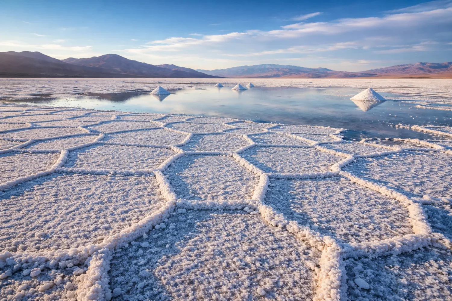
Why Polygon Patterns Appear on Salt Pans
Few desert surfaces are as recognizable as salt polygons. They appear in Death Valley, in Iranian salt flats, in Andean salars, and in many dry basins where crusts grow, crack, lift, and settle again. Those polygons form because the crust is not static. It responds to evaporation, thermal contraction, crystal growth, sediment shrinkage, and tiny differences in moisture below the surface.
Cracks open. Brine moves upward. Salt re-precipitates along the edges. Rims stand slightly higher than polygon centers, or the centers puff up while edges sink, depending on local conditions. A short walk across a salt pan can show this process in stages: smooth crust, broken crust, raised rims, popcorn-like efflorescence, soft saline mud, then hard dry plates again. Flat, yes. Uniform, not at all.
These patterns are more than scenery. They act as small-scale maps of water movement. Where the crust thickens, where it breaks, where it crusts over again after flooding, the basin is revealing how moisture and solute flow near the surface. That is why salt polygons attract both geomorphologists and remote-sensing scientists. They are readable forms, almost like a mineral handwriting across the basin floor.
Plants, Birds, and Micro-Life in Salty Drylands
Salt deserts look empty from afar, yet their edges can support life adapted to osmotic stress, alkaline soils, heat, cold nights, and irregular water. Halophytes such as saltbushes, greasewood, glasswort-like plants, saltgrass, tamarisk in some disturbed settings, and other salt-tolerant shrubs often grow where saline moisture is present but the ground is not fully bare. They are rarely lush. They are efficient.
These plants solve a difficult problem: how to take up water when the soil solution is so saline that water is hard to pull into roots. Some exclude salts at the root surface. Some store salts in vacuoles. Some shed salt-loaded tissues. Some excrete salt through specialized glands. Their presence tells you that a basin margin is saline, but not sterile.
Bird life often concentrates not on the driest crust, but on saline wetlands, shallow lagoons, marsh edges, and seasonal pools within the wider basin. Andean salars, especially in the Atacama region, are well known for saline lagoons used by flamingos and other waterbirds. Great Basin playas support migratory bird use when water persists seasonally. What seems like one desert landform from space can function as several habitats on the ground.
Microbial life matters too. Thin wet films, brines below the crust, and saline muds can support bacteria and archaea adapted to hypersaline settings. Their activity can influence color, sediment texture, and geochemical cycling. In the driest basins, life may sit low, sparse, and patchy. Still there, though. Salt deserts reduce abundance, but they do not erase biology.
Three Ecological Points Often Missed
- Bare pan centers and saline edges can behave like different ecosystems.
- What looks dry on top may still be moist and saline just below the surface.
- Many salt deserts are linked to ephemeral wetlands, which matter far more to wildlife than the bright crust alone.
Where Salt Deserts Cluster Around the World
Salt deserts tend to gather in places where dryness meets internal drainage. That means continental interiors, rain-shadow basins, high plateaus, and subsiding depressions. The Andes host famous salars. Iran and Central Asia hold broad saline basins across interior plateaus and desert margins. The Basin and Range country of western North America carries one playa after another. North Africa and the Arabian region show saline depressions, chotts, sabkhas, and crusted pans where evaporation dominates water loss.
That global spread is not random. Endorheic basins cover a large share of continental land, often estimated at around a fifth of the land surface, and many lie in water-stressed drylands. Once you combine a closed basin, mineral supply, and long-term aridity, the odds tilt toward salinity. Sometimes the result is a dramatic white pan. Sometimes it is a salty clay flat with only patchy crust. Sometimes it is a broad desert in which saline basins punctuate dunes, alluvial fans, rocky uplands, and playa floors.
So when people ask where the world’s salt deserts are, the answer is not a single belt. It is a repeating dryland pattern. Interior low point. Intermittent inflow. No outlet. Strong evaporation. Reworked minerals. The basin may sit below sea level, like Death Valley; on a high plateau, like the Atacama salars; on the bed of an ancient lake, like Black Rock Desert; or inside the Iranian plateau, where Dasht-e Kavir, Maranjab, Polond, and Dasht-e Lut show several faces of saline desert terrain at once.
How To Read a Salt Desert Landscape
A salt desert becomes easier to understand once you stop looking at it as a blank sheet. Most saline basins have a simple spatial logic. Basin margins often carry alluvial fans and coarser sediment. Slightly lower belts may hold shrubs or saline marsh vegetation. Closer to the center, sediment gets finer, water sits longer after floods, and salts tend to concentrate more strongly. The flattest, whitest part is often only one zone in a bigger basin system.
Look for these elements:
- Mountain or plateau rims that supply runoff and sediment
- Alluvial fans grading down toward the basin center
- Vegetated saline margins where groundwater is shallow
- Mudflats that flood and dry quickly
- Hard salt crust near the lowest local points
- Brine pools or seasonal lagoons after wetter spells
- Dunes where wind reworks sand from basin edges
- Pressure ridges and polygons where crust chemistry and moisture vary
Once you see that pattern, many deserts that seem unrelated begin to line up. Death Valley and Black Rock Desert differ in altitude, temperature, and geologic setting, yet both preserve former lake floors. The Atacama and Lop Desert differ in scale and altitude, yet both show how closed basins trap salts under very low rainfall. Iranian deserts add another layer: saline pans interlocked with dunes, marshes, lake remnants, clay flats, and mixed evaporite terrains. Same basic logic. Different expression.
North American Salt Basins: Ancient Lakes Turned White Flats
Death Valley: A Low Basin With a Classic Salt Pan
Badwater Basin is one of the clearest salt-desert examples anywhere. The basin floor lies about 282 feet (86 meters) below sea level, making it the lowest point in North America, and the salt flats cover nearly 200 square miles. The surface is made mainly of sodium chloride, with calcite, gypsum, and borax also present. Those numbers matter because they show the basin is not just dry, but chemically concentrated and topographically primed to hold runoff.
The modern pan sits where ancient Lake Manly once occupied the valley floor during wetter climatic phases. When that lake shrank and vanished, it left behind sediment and salts. Today groundwater continues to rise through those deposits, and evaporation builds the famous polygonal crust. It is a living evaporite surface, not a fossil one. The flat is still forming, still cracking, still re-salting itself.
Death Valley also shows how extreme topography sharpens salinity. Steep mountain fronts push sediment and dissolved ions down into a deep enclosed trough. Runoff is episodic, yet when water arrives it has few places to spread except across the basin floor. Because evaporation is intense, even shallow water films can deposit visible minerals in short order. Fast flood. Thin lake. Dry crust. The cycle is blunt and efficient.
There is another lesson here. People often think a salt flat is a surface feature only. In Death Valley, the surface works because of what lies beneath it: shallow saline deposits, groundwater flux, buried lake sediment, and a basin geometry that keeps salts focused in the low center. Strip away the hydrology, and the white polygons would not last long.
Black Rock Desert: A Playa on the Bed of Lake Lahontan
Black Rock Desert in Nevada offers a different but equally instructive salt-basin landscape. The playa is also about 200 square miles in size and marks part of the floor of former Lake Lahontan, the great pluvial lake that once covered much of northwestern Nevada. What remains today is a vast desert playa inside a much larger conservation landscape.
Compared with Death Valley, Black Rock feels broader, cooler, and more open, but the basin logic is familiar. A low closed floor collects water from the surrounding uplands. Seasonal wetting creates a smooth muddy surface. Drying then hardens the floor and can leave saline and alkaline patches, fine sediment crusts, and broad reflective stretches under certain light. The basin is famous for its flatness, yet that flatness came from lake processes, not from some simple desert planing.
In geomorphic terms, Black Rock is useful because it sits in the Great Basin, a region packed with internal drainage. That makes it a model landscape for understanding how playas, saline lakes, and alkali flats relate to one another across a basin-and-range desert. Not every low flat is equally salty. Not every saline basin is equally crusted. Black Rock shows one part of that spectrum well: a broad playa that owes its shape and fine sediment to lake history.
It also reminds us that salt deserts are often seasonal surfaces. A basin may appear firm and pale in one period, then hold shallow water after storms or snowmelt-fed inflow, then return to hardpan again. The salt-desert look is real, but it is also dynamic. On dryland basin floors, stillness is often just a pause between states.
| North American Basin | Landform Type | Why It Matters | Visible Clues |
|---|---|---|---|
| Death Valley | Low-elevation salt pan in a deep closed basin | Classic example of groundwater-fed polygonal salt crust on a former lake floor | Bright halite flats, raised polygons, basin-floor salt deposits |
| Black Rock Desert | Large playa on an ancient pluvial lake bed | Shows how former lake basins evolve into broad desert playas and saline flats | Flat muddy pan, seasonal water, alkaline and saline surface zones |
African Contrast: The White Desert and the Problem of Surface Appearance
White Desert National Park: White, Dry, and Often Misread
The White Desert National Park in Egypt sits within the country’s Western Desert and protected area system, covering roughly 3,000 square kilometers. It is one of the world’s most recognizable pale desert landscapes. Yet it is not a giant halite pan in the same sense as Badwater Basin or Salar de Atacama. Its fame rests mainly on chalk and limestone formations shaped by wind erosion, ancient marine sediment, and desert weathering.
That distinction is not a technical quibble. It fixes a common content gap in many broad “white desert” articles. A white surface can come from carbonate rock just as easily as from salt precipitation. In the White Desert, the sculpted forms, chalky debris, and pale rock masses tell a story of sedimentary geology and aeolian carving more than basin-floor halite accumulation.
So why include it in a pillar page about salt deserts and saline basins? Because real desert reading requires categories with edges. The White Desert helps draw those edges. It belongs in the larger saline-arid conversation because it sits in an evaporative desert context where closed depressions, saline soils, and white mineral surfaces are all part of the wider regional picture. Yet it also stands as a warning: visual brightness is not enough to classify a salt desert.
Seen that way, the White Desert becomes useful rather than awkward. It is the comparison case. It says: look beyond color, ask what the white surface is made of, and check whether the basin is controlled by evaporite hydrology or by carbonate bedrock and erosional sculpture. Many readers skip that step. They should not.
South American Salars: High Plateau Chemistry and Extreme Aridity
Atacama Desert: Salt Basins on One of Earth’s Driest Desert Landscapes
The Atacama Desert is famous for dryness, but for salt-desert geography its real value lies in its network of salars and saline basins. The best-known is Salar de Atacama, Chile’s largest salt flat, covering about 3,000 square kilometers at an average elevation of roughly 2,300 meters above sea level. This is a high desert basin, not a low inland trough like Death Valley.
Parts of the Atacama rank among the driest places on Earth. Some sectors average only a few millimeters of rain per year, and some stations in the driest core have gone extraordinarily long periods without recorded rainfall. That dryness is one reason the region preserves salt basins so clearly. Little surface water flushes the system. Water that does arrive from the Andes often ends in internal drainage, where evaporation does the rest.
The Atacama also shows how a saline basin can be both geomorphic and hydrochemical. The surface crust is only one layer. Beneath it are brines, porous sediments, and hydrogeologic pathways tied to mountain runoff and basin fill. In satellite imagery, salar margins, lagoons, alluvial fans, and evaporation ponds can all appear in the same frame. That arrangement makes the Atacama one of the clearest places on Earth to see how salt flat morphology and brine hydrology fit together.
Ecology sharpens the picture further. Saline lagoons on the margins of Andean salars support bird life, especially flamingos, where chemistry and shallow water create biological niches. So the Atacama is not simply “the driest desert.” It is also a desert of saline contrasts: hard crust and wet lagoon, barren core and edge habitat, mineral flat and volcanic backdrop, fine mud and crystalline salt.
Another point often missed: the Atacama is not one single salt flat but a desert region with many saline expressions. Nitrate plains, volcanic basins, saline depressions, alluvial aprons, and salar systems sit beside each other. That is why it belongs in any serious salt-desert discussion. It is not just home to a salt flat. It is a desert where salinity is woven into the regional landform system.
Why The Atacama Matters in This Topic
The Atacama is one of the best places to see how closed-basin hydrology, extreme aridity, evaporite minerals, and saline lagoons interact in one desert region. It is a basin network, not just a postcard salt pan.
Asian Salt Deserts: Dry Lake Basins, Iranian Kavirs, and Mixed Evaporite Landscapes
Lop Desert: The Salt Legacy of Lop Nur
The Lop Desert in Xinjiang centers on the old Lop Nur basin, a former salt lake in one of Asia’s driest continental interiors. NASA observations note average annual precipitation near 31.2 millimeters and annual evaporation around 2,901 millimeters. That ratio says almost everything. Water input is tiny. Water loss is vast. In a closed basin, that is a direct recipe for salt concentration.
Lop Nur dried gradually through the Holocene, and the basin now preserves the look of a dried salt lake more than an active open water body. The ground can show pale salt remnants, dry sediment, and large industrial-scale evaporation geometry in parts of the wider basin. Strip away the modern human overlay and the core geomorphic message remains: this is an evaporative terminal basin in an extreme continental desert.
What makes Lop especially instructive is scale. The basin sits within a huge arid region where wind, old lake sediment, river diversion, and deep desert dryness all intersect. It is not a neat ring of white around a shallow pond. It is a broad landscape where the memory of a lake survives as salt-rich sedimentary terrain. Many world salt-desert articles rush past this kind of basin because it does not always present one photogenic polished pan. They should not. Lop shows the drier, harsher end of the saline-basin spectrum.
There is also a climatic lesson in it. Closed basins can shift from lake to marsh to saline flat to dust-prone dry pan as inflow changes. Once a basin crosses certain thresholds, salt does not vanish with the water. It becomes more visible. Lop Nur is a strong example of that threshold effect.
Dasht-e Kavir: Iran’s Great Salt Desert
If one desert in Iran deserves the plain label Great Salt Desert, it is Dasht-e Kavir. Sprawling across the central Iranian plateau, it is often described at around 77,000 square kilometers, though the wider saline-basin system grades into adjacent deserts and protected landscapes. UNESCO’s Kavir Biosphere Reserve, which includes part of the Great Salt Lake basin and Dasht-e Kavir, covers 691,163 hectares and records 205 plant species, with 35 endemic. That alone tells you the region is not a blank white void. It is a structured desert mosaic.
Dasht-e Kavir is the kind of desert that forces people to separate salt desert from sand desert. Dunes do occur in the wider region, but the classic image here is the kavir: a saline or muddy lowland with crusted surfaces, marshy flats, clay pans, and low relief that can look deceptively firm. The basin floor often combines mud, salt, and moisture in a way that makes the surface difficult to judge by sight alone. Crust above. Soft ground below. Common in kavir terrain.
This is where Iranian desert terminology becomes helpful. A “kavir” is not simply a sea of table salt. It can include salt marshes, mud flats, saline soil plains, shallow lake remnants, and polygonal crust zones, all within one large basin system. That makes Dasht-e Kavir a stronger educational example than a simpler, more uniform pan. It teaches basin complexity.
The desert also shows how regional structure matters. Mountains around the Iranian plateau feed intermittent runoff toward low centers. Water spreads, ponds, and evaporates. Fine sediment accumulates in the lowest zones. Salts rise and re-precipitate. On the edges, where gradients are slightly higher and groundwater may sit at workable depth, vegetation can appear. A few kilometers away the basin center can be nearly bare. Short transitions. Sharp contrasts.
Many broad articles flatten Dasht-e Kavir into one sentence: “Iran’s Great Salt Desert.” True, but thin. What makes it stand out is the interplay of saline pan, clay flat, marshy depression, dune belt, and protected desert steppe. That mixed character is the real story.
Maranjab Desert: Dunes Meeting Salt Pans on the Edge of the Kavir
Maranjab Desert sits on the northern margin of the wider Dasht-e Kavir system and is one of the clearest places to see how sand seas and salt flats meet. It is tied to the Aran and Bidgol area and to nearby saline depressions and salt-lake zones. Unlike a purely central playa, Maranjab is a transition landscape. Dunes, seasonal wetlands, and saline flats stand close together.
That matters because many readers assume a salt desert must be flat from edge to edge. Maranjab says otherwise. In reality, basin margins often carry wind-reworked sand while lower sectors preserve saline crusts and damp flats. The result can be visually dramatic: golden dunes rising above pale salts, then dark wet ground in low pockets after runoff. Same basin family, very different textures.
Its setting near larger salt-lake and pan systems makes Maranjab useful for understanding desert adjacency. Some landforms are neighbors because of tourism maps; others are neighbors because of basin hydrology. Maranjab belongs to the second kind. The dunes are not an interruption of the saline system. They are part of the broader desert machine, built from sediment supply, wind corridors, topographic breaks, and moisture gradients around a low saline interior.
That is why Maranjab often feels more layered than a simple salt flat. It is a basin-edge desert where the traveler’s eye may lock onto the dunes first, but the geologic logic runs through the nearby saline lowlands. Quietly, salt still organizes the landscape.
Polond Desert: A Smaller Iranian Example With Salt Flats and Low Pans
Polond Desert, also known as Kavir-e Polond or the Mozaffari Desert, shows the same Iranian pattern in a more compact form. It lies in South Khorasan within the Mozaffari protected landscape and includes sandy hills, salt flats, and low-lying salt pans set against uplands and mountain-backed desert. That mixed topography is one reason Polond deserves space in a pillar page like this.
Not every salt desert needs to be continent-famous to matter. Smaller saline deserts often reveal the structure more clearly because the transitions are visible at shorter range. In Polond, dune forms, basin lows, and saline ground occur in one connected dryland field. The eye can track the change from sandy surface to pale salt pan without losing the broader terrain. For reading landforms, that is useful.
Polond also helps correct another weak habit in desert writing: treating Iranian deserts as if Dasht-e Kavir and Dasht-e Lut are the whole story. They are the giants, yes. Yet the country’s saline geography is made of many linked desert sectors, protected areas, marshy flats, pans, dune corridors, and basins. Polond is one of the regional examples that makes the whole pattern easier to understand.
Small in profile, revealing in structure. That is Polond’s value here. It shows how saline terrain can coexist with sand hills and rocky relief without losing its basin identity.
Dasht-e Lut: Heat, Yardangs, and Salt Within a Larger Desert System
Dasht-e Lut is often introduced through heat records and spectacular yardangs, and rightly so. NASA describes it as a landscape of extremes stretching across roughly 7,000 square miles, while UNESCO highlights it as one of the hottest places on Earth and one of the world’s great hot-desert landscapes. Yet for a salt-desert discussion, the value of Lut lies in its mixed geomorphology: salt plains, desert flats, dunes, and erosion-shaped ridges all occur within one major interior basin system.
That means Lut should not be filed away as “the hot one” and left there. The desert includes broad barren surfaces where evaporitic and saline processes matter, even if the yardangs steal the visual attention. In southeastern Iran, aridity is so strong and drainage so limited that basin-floor chemistry still has room to write itself across the land. Salt may not dominate every famous photograph, but it remains part of the desert’s real structure.
Lut is also a reminder that salt deserts do not always look white. Iron-rich sediment, dark gravels, wind-sculpted ridges, and heat-shocked surfaces can dominate the color palette, while saline flats occupy lower sectors within the larger desert fabric. This matters for global classification. If a reader expects every saline basin to resemble a white mirror, they will miss half the story. Lut broadens the eye.
Another useful point: Dasht-e Lut and Dasht-e Kavir are often paired, but they are not interchangeable. Dasht-e Kavir is the more direct “Great Salt Desert” model, with classic salty lowlands and marshy flats. Dasht-e Lut is the harsher mixed desert where saline surfaces share space with giant erosional forms and broad sand sectors. Same country. Different desert logic.
| Asian Desert | Main Saline Expression | Landscape Character | What It Teaches |
|---|---|---|---|
| Lop Desert | Dried salt-lake basin | Extreme continental aridity, old lake-bed sediment, evaporative concentration | How a terminal lake becomes a desert salt basin |
| Dasht-e Kavir | Great saline basin with mudflats, marshes, and crusted pans | Broad central plateau desert with mixed kavir terrain | Why a salt desert is often a mosaic, not one flat surface |
| Maranjab Desert | Salt-lake margin and pan system beside dunes | Transitional basin-edge desert | How dunes and salt flats can coexist naturally |
| Polond Desert | Salt flats and low pans within protected desert terrain | Compact mixed desert with sandy hills and saline lows | How smaller deserts reveal basin structure clearly |
| Dasht-e Lut | Salt plains within a larger hot-desert basin system | Extreme heat, yardangs, broad barren flats, dunes | Why saline landscapes are not always bright white |
How These Nine Deserts Compare
Set side by side, these deserts show that salt desert is not one look but a family of landforms. Death Valley is a low deep pan with classic polygons and a groundwater-fed crust. Black Rock Desert is a huge lake-bed playa where the saline story is tied to Great Basin hydrology. Atacama is a high plateau desert of multiple salars and brine systems. Lop Desert is the remnant of a dried terminal lake in a far inland continental desert. Dasht-e Kavir is the basin-wide model of salty mudflats and marshy kavirs. Maranjab and Polond show smaller mixed landscapes where dunes and saline lows sit together. Dasht-e Lut stretches the definition into a wider hot-desert basin with salt plains embedded inside a larger geomorphic spectacle. White Desert draws the line between chalk whiteness and true evaporite dominance.
This comparison fixes one more common gap. A lot of online content treats salt deserts as scenic white emptiness. That is too shallow. A salt desert is better understood through four linked questions:
- Is the basin closed?
- Where does the water come from?
- Which minerals dominate the surface and shallow subsurface?
- How does the basin connect to dunes, fans, marshes, or uplands around it?
Ask those four questions and the landscapes become clearer. Death Valley answers them one way. The Atacama answers them another. Iranian kavirs answer them in several overlapping ways at once. White Desert answers by partly refusing the label and, in doing so, sharpening it. Useful, that kind of desert is.
| Desert | Continent | Best Short Description | Approximate Technical Marker |
|---|---|---|---|
| Death Valley | North America | Deep closed-basin salt pan | Badwater Basin at 86 m below sea level; salt flats near 518 km² |
| Black Rock Desert | North America | Ancient lake-bed playa | Playa around 200 square miles |
| White Desert National Park | Africa | Chalk-white desert, not a classic halite pan | Protected area around 3,000 km² |
| Atacama Desert | South America | Hyper-arid desert with major salar systems | Salar de Atacama around 3,000 km² and about 2,300 m elevation |
| Lop Desert | Asia | Dried salt-lake basin | ~31.2 mm annual precipitation; ~2,901 mm annual evaporation |
| Maranjab Desert | Asia | Dune-and-salt transition desert | Salt flats tied to larger Kavir basin margins |
| Polond Desert | Asia | Protected mixed desert with saline lows | Salt flats and low pans inside Mozaffari desert terrain |
| Dasht-e Lut | Asia | Extreme hot desert with salt plains and yardangs | About 7,000 square miles in extent |
| Dasht-e Kavir | Asia | Great Salt Desert of Iran | Commonly described near 77,000 km²; Kavir reserve 691,163 ha |
Why Salt Deserts Matter Beyond Scenery
Salt deserts matter because they are visible endpoints of hidden water balance. They tell us where drainage stops, where dissolved loads accumulate, and where climate has tipped the ledger toward evaporation. In that sense they are natural hydrology maps spread across the ground. A bright pan is a record of imbalance made visible.
They matter for soil science too. Global assessments now show that salt-affected soils occupy a very large share of Earth’s land surface, with drylands carrying much of that burden. Salt deserts are not the whole salinity story, but they are the most exposed expression of it. When a basin floor grows whiter, harder, or dustier, it is showing the long-term outcome of water scarcity, mineral concentration, and poor flushing capacity.
They matter for ecology because even sparse saline habitats support specialized plant and animal communities. They matter for geomorphology because they preserve traces of paleolakes, groundwater motion, wind reworking, and sediment concentration. They matter for remote sensing because evaporite surfaces stand out strongly in satellite imagery. And they matter for desert classification because they force precision. Sand desert, stony desert, chalk desert, salt pan, playa, salar, saline marsh, alkali flat. The differences are real.
One short basin can hold all of those forms in sequence. That is the point. Salt deserts are not side notes in world desert geography. They are one of its clearest organizing patterns.
What Most People Miss When Looking at a Salt Flat
The first thing most people notice is whiteness. The second is flatness. The third, if they step closer, is the crack pattern. What they often miss is the vertical structure: dust or crust on top, softer saline mud beneath, then moist sediment or brine lower down. A desert basin can appear dry, bear only a thin crust, and still remain chemically active below the surface.
They also miss the margins. The center gets the photographs, but the margins explain the system. Alluvial fans deliver water and solutes. Vegetated belts reveal shallow groundwater. Lagoon edges show where chemistry still supports aquatic or semi-aquatic life. Dunes show where wind removes and reworks basin sediment. Read the edge and the center starts to make sense.
And many miss the fact that different white deserts have different origins. Some are halite plains. Some are gypsum fields. Some are chalk landscapes. Some are mixed saline-clay basins where the white is seasonal or patchy. The White Desert and Death Valley may share visual brightness in a photograph, yet geologically they belong to different stories. That difference is not pedantic. It is the difference between erosional whiteness and evaporite whiteness.
Seen properly, salt deserts are not monotonous at all. They are some of the most information-rich surfaces in dryland geography. Quiet surfaces, yes. Empty ones, no.
The Pattern That Links These Salt Deserts
From California to Nevada, from Egypt’s Western Desert to northern Chile, from Lop Nur to the Iranian plateau, the same broad sequence keeps returning. A basin closes. Water collects. Minerals accumulate. Evaporation outpaces flushing. Crusts form. Floods return. The crust breaks, heals, and shifts. Life pulls back to the margins or adapts to the chemistry. Sediment, salt, and time do the rest.
Yet each desert modifies that sequence in its own way. Death Valley sharpens it with low elevation and concentrated groundwater-fed crusts. Black Rock Desert spreads it across a giant former lake bed. Atacama lifts it to high plateau salars under near-rainless skies. Lop Desert shows the dried residue of a vanished inland lake. Dasht-e Kavir turns it into vast salty lowlands. Maranjab and Polond braid it with dunes and upland relief. Dasht-e Lut folds it into one of the harshest hot-desert settings on Earth. White Desert, by contrast, teaches where the salt-desert label should stop.
That is why salt deserts deserve their own pillar page. They are not simply pretty white places in dry countries. They are chemical landscapes, hydrologic endpoints, archives of vanished water, and some of the clearest proof that in desert geography, what stays behind often matters more than what arrives. Slow work, salt does. Very slow. But on basin floors across the world, it leaves almost nothing untouched.
And once you start reading deserts that way, the world’s saline basins stop looking empty. They start looking precise.