A desert is not simply a hot place with sand. It is a dry region where yearly precipitation usually stays below 250 millimeters and where water loss often outruns water input. That is the real test. Some deserts bake under strong sun. Others stay cold enough for snow and ice. Even so, the moisture budget stays tight, and that is what shapes the land.
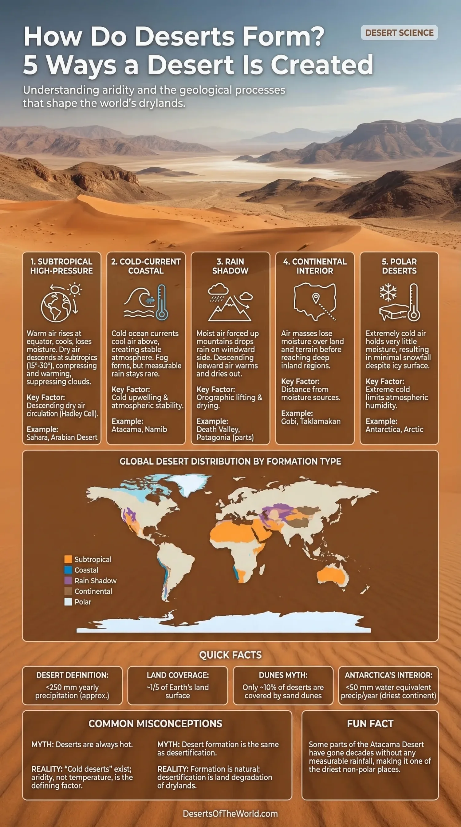
Across Earth, deserts cover about one-fifth of the land surface, while broader drylands make up more than 40%. Another detail surprises many readers: only about 10% of deserts are covered by dunes. Much of the rest is gravel plain, bedrock, salt flat, dry basin, or ice-covered ground. Dryness, not sand, is the common thread.
| Desert Formation Pattern | What Happens in the Air | Where It Usually Appears | Example |
|---|---|---|---|
| Subtropical High-Pressure Deserts | Air rises near the equator, loses moisture, then descends warm and dry | Mostly around 15° to 30° latitude, often near the subtropics | Sahara, Arabian Desert |
| Cold-Current Coastal Deserts | Cold ocean water cools the air, fog forms, rain stays scarce | West coasts of continents near the tropics | Atacama, Namib |
| Rain Shadow Deserts | Mountains force air upward, rain falls on one side, dry air drops on the other | Leeward side of major mountain ranges | Death Valley, parts of Patagonia |
| Continental Interior Deserts | Moisture rarely reaches far inland | Deep inside large continents | Gobi, Taklamakan |
| Polar Deserts | Extremely cold air holds very little moisture | High-latitude polar regions | Antarctica, Arctic polar areas |
What Actually Makes a Place a Desert?
The science comes down to aridity. If a landscape gets very little precipitation and loses moisture fast through evaporation and evapotranspiration, plant cover stays thin, streams become temporary, and soils often hold little organic matter. In climate classification, true desert climates are often labeled BW, with BWh for hot desert climates and BWk for cold desert climates.
This matters because many people still tie deserts only to heat. A cold desert is still a desert. Antarctica proves that point better than any textbook line. Much of the high interior gets less than 50 mm water equivalent precipitation per year, even though the continent stores vast amounts of frozen water. The surface looks icy. The moisture supply is still tiny. A diferent story than most expect.
The 5 Main Ways a Desert Forms
1. Subtropical High-Pressure Belts Create Large Hot Deserts
This is the best-known pathway. Warm, moist air rises near the equator, cools, and drops much of its moisture as rain. After that, the now drier air moves poleward and sinks over the subtropics. As it descends, it compresses and warms. Relative humidity falls. Clouds struggle to form. Rain becomes rare.
That sinking branch of the Hadley cell helps explain why so many famous deserts sit near the subtropics. Meteorological sources place the Hadley circulation from the equator to roughly 30 to 40 degrees north and south. The world’s hot desert belt fits that pattern well.
The Sahara and the Arabian Desert are classic cases. They lie under long-lived high-pressure zones where subsiding air suppresses cloud growth for much of the year. The result is persistent dryness, strong sunshine, and a large gap between rainfall events.
- Main process: Descending dry air linked to global atmospheric circulation
- Typical landforms: Rocky plains, ergs, gravel surfaces, dry wadis, salt flats
- Common climate signal: Very low cloud cover and high evaporation demand
2. Cold Ocean Currents Build Coastal Deserts
Some deserts form right next to the sea, which sounds backwards at first. The reason is the ocean itself. Along certain west coasts, cold ocean currents and upwelling cool the air above the water. Cool air does not rise easily, so the atmosphere stays stable. Fog and low cloud may appear, but rain stays scarce.
This is why a coastal desert can feel damp in the morning and still be almost rainless on the yearly chart. The Atacama Desert in Chile shows this well. Parts of it can go decades without rainfall, and measurable rain of 1 millimeter or more may occur only once every 5 to 20 years in some zones. That is extreme even by desert standards.
The Namib Desert works in a similar way along the Benguela Current. Fog matters there. It supports life, softens the morning air, and feeds certain plants and animals, yet it does not turn the region into a wet climate. A place can receive moisture in the form of fog and still stay firmly in the desert category.
- Main process: Cold current, atmospheric stability, low rainfall
- Typical landforms: Coastal dunes, gravel plains, fog-fed margins
- Common climate signal: Fog is frequent, rain is not
3. Mountains Create Rain Shadow Deserts
Mountains can strip moisture from the air like a barrier wringing out a wet cloth. Moist air hits the windward slope, rises, cools, and drops rain or snow. By the time that air crosses the crest and starts down the leeward side, it has lost much of its water. Descending air warms, relative humidity drops, and the sheltered side dries out fast.
This is the rain shadow effect, also called orographic drying. It creates sharp contrasts over short distances. One side of a mountain range may support forests or grasslands. The other side may turn sparse, dusty, and arid.
Death Valley sits in the rain shadow of the Sierra Nevada. Parts of the Tibetan Plateau and leeward basins around Central Asia also show strong rain shadow control. In South America, the Andes help dry out areas to the west and east depending on local airflow patterns. So, mountains do not just decorate desert maps. They help draw them.
- Main process: Orographic lift on one side, dry descending air on the other
- Useful terms: Windward slope, leeward slope, adiabatic warming, rain shadow
- Field clue: A sudden vegetation drop across a mountain divide
4. Continental Interiors Become Dry Because Moisture Runs Out Before It Arrives
Some deserts form far from any ocean. Air masses moving inland lose part of their moisture along the way through rain, snow, and repeated terrain crossings. By the time they reach the middle of a large continent, there is not much water left to give.
That is how continental interior deserts develop. The Gobi Desert is the clearest example. It lies deep inside Asia, hundreds of kilometers from the sea, and also feels the drying effect of nearby uplands and mountain systems. Many areas receive less than 200 mm of precipitation per year, and winters can be bitterly cold. So yes, an inland desert can be both dry and sharply seasonal.
This type of desert often fools people because it may not look like the stereotype. The Gobi has gravel plains, bare rock, and broad basins more often than postcard dunes. Sparse rainfall, strong winds, and large temperature swings shape the surface. Distance from moisture matters more here than heat alone.
- Main process: Air loses moisture before reaching the continental interior
- Typical landforms: Basins, stony plains, dry valleys, alluvial fans
- Common climate signal: Low rainfall and wide seasonal temperature range
5. Polar Regions Form Cold Deserts
Polar deserts break the old myth that deserts must be hot. In very cold air, the atmosphere holds little moisture to begin with. Cloud formation stays limited, snowfall stays light over the long term, and the landscape remains arid even when ice is present.
Antarctica is the largest desert on Earth by area. The whole continent averages about 150 mm water equivalent precipitation per year, while the elevated interior plateau drops below 50 mm. In some coastal sectors precipitation rises above 200 mm and can exceed 1,000 mm locally, but the interior remains one of the driest places on the planet.
Polar deserts also behave differently at the ground surface. Freeze-thaw action, patterned ground, exposed bedrock, and gravel plains often matter more than dunes. Water may be present as ice, yet biologically available liquid water stays scarce for much of the year. Cold deserts are dry first, cold second. That order matters.
- Main process: Air is too cold to carry much moisture
- Typical landforms: Ice-free valleys, gravel plains, patterned ground
- Common climate signal: Very low precipitation despite frozen landscapes
Why One Desert Often Has More Than One Cause
Rare is the desert that forms for only one reason. In real landscapes, desert formation processes can overlap. The Atacama is a good exmaple. It is a coastal desert linked to a cold current, but the Andes also strengthen its dryness through a rain shadow effect. The Gobi is an interior desert, yet nearby high terrain also shapes how moisture moves.
That overlap explains why some deserts reach such extreme dryness. When descending air, cold currents, mountain barriers, and continental distance work together, rainfall can collapse to very low levels for long periods. The landscape then shifts toward desert soils, sparse vegetation, ephemeral streams, salt buildup, and stronger wind action.
Why Deserts Are Dry, Not Necessarily Hot or Sandy
Searchers often ask how deserts form and then imagine only dunes and blazing afternoons. The science is broader than that. A desert may be a gravel plain, a salt basin, a plateau, or an icy polar expanse. It may receive fog, snow, or a rare thunderstorm. What matters is the long-term water balance.
That is why the phrase desert climate belongs to hydrology and meteorology as much as to scenery. Once yearly input stays low and evaporation demand stays high, soils dry out, plant cover thins, channels run only after short-lived storms, and wind gains more room to move sediment. The land starts to behave like a desert because, climatically, it is one.
Desert Formation Is Not the Same as Desertification
One last distinction helps. Desert formation describes the natural climate and geographic processes that create arid regions. Desertification describes land degradation in drylands, where stressed soils and vegetation begin to behave more like desert terrain. The two ideas are related, though they are not the same thing.
Keeping them separate makes the topic clearer. The Sahara, Atacama, Namib, Gobi, and Antarctica are deserts because the atmosphere, ocean, landform, and latitude support long-term dryness. Desertification happens when already dry or vulnerable lands lose resilience and shift further toward barren conditions.
Sources
- U.S. Geological Survey – Deserts (desert definition, annual precipitation threshold, hot and cold desert examples)
- National Geographic Education – Desert (five desert types, desert land coverage, dunes share, Atacama and polar desert context)
- Met Office – Global Circulation Patterns (Hadley cells, sinking subtropical air, hot desert belt formation)
- U.S. Geological Survey – Types of Deserts (coastal deserts, rain shadow deserts, polar desert data, Atacama rainfall frequency)
- Australian Antarctic Program – Antarctic Weather (Antarctica precipitation patterns, plateau dryness, temperature and wind data)
- NASA Earth Observatory – Cloudy Earth (descending subtropical air, west-coast upwelling, mountain rain shadow context)
- Penn State – The Orographic Effect (how rising and descending air create rain shadows on mountain flanks)