
About one-fifth of Earth’s land area is desert under a commonly cited biome-level estimate. With Earth’s land area at roughly 149 million km², applying that 20% estimate gives about 29.8 million km². Measured against the planet’s full surface, land and ocean together, the same calculation gives about 5.8%. These are derived values rather than a single mapped global desert total. Broader classifications can produce higher shares, especially when polar deserts and other arid zones are counted differently.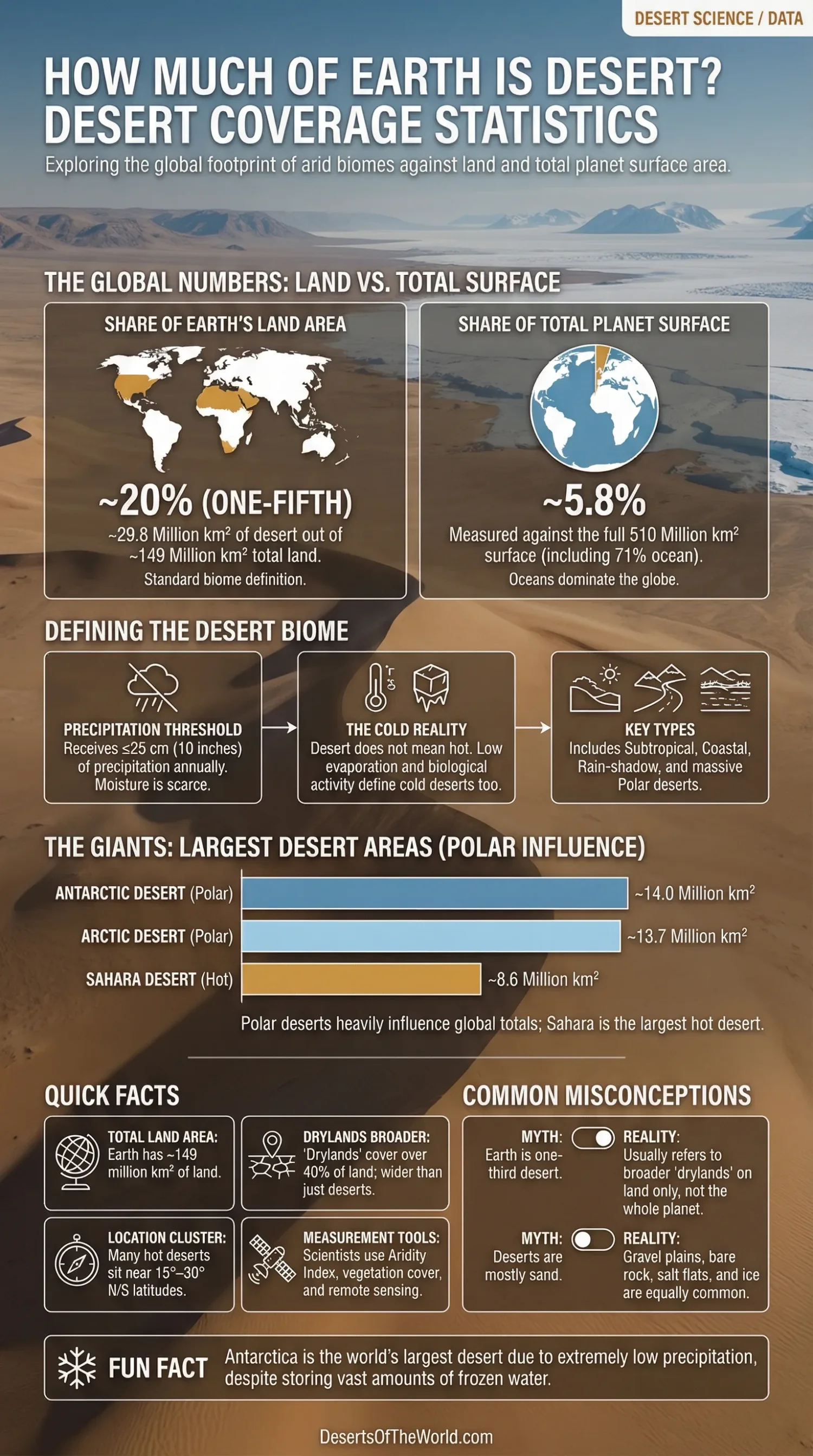
| Measure | Approximate Figure | What It Tells You |
|---|---|---|
| Earth’s Total Surface | About 510 million km² | The whole planet, including oceans |
| Earth’s Land Area | About 149 million km² | The part deserts are measured against most often |
| Common Desert-Biome Estimate | About 20% of land | A widely used biome-level estimate |
| Area Implied by the 20% Estimate | About 29.8 million km² | An arithmetic conversion of the one-fifth estimate |
| Full-Surface Share Implied by the 20% Estimate | About 5.8% | Derived from the one-fifth-of-land estimate |
| Dryland Share of Land | Over 40% | Broader than desert; includes semi-arid and some drier transition zones |
These figures are rounded. The 20%, 29.8 million km², and 5.8% values are parts of the same calculation. Desert totals still vary among sources because definitions, map boundaries, and polar coverage do not always match.
What Counts as a Desert
A desert is usually defined as land that receives no more than 25 centimeters (10 inches) of precipitation a year. That sounds simple. Still, desert science is not built on rainfall alone.
Evaporation matters too. So does plant cover. In very cold places, snow may fall instead of rain, yet the land still behaves like a desert because moisture is scarce and biological activity stays low. That is why desert does not mean hot. Cold can do it too.
Most global references place deserts into broad groups such as:
- Subtropical deserts near the belts of sinking dry air, including the Sahara and Arabian Desert
- Coastal deserts shaped by cold ocean currents, such as the Atacama and Namib
- Interior and rain-shadow deserts, common in Central Asia and western North America
- Polar deserts, where moisture is low even though ice is present, especially Antarctica and parts of the Arctic
That last category changes the conversation a lot. Leave polar deserts out, and the global total falls. Count them in, and the number climbs fast.
How Much of Earth Is Desert?
By Land Area
A widely used biome-level figure is about one-fifth of Earth’s land area. Applied to roughly 149 million km² of land, that estimate is equivalent to about 29.8 million km². The converted area remains approximate because global desert boundaries are not defined identically by every source.
There is a second answer, and it is the one that creates confusion: some broader estimates push desert and very dry land toward one-third of global land area. That does not mean one-third of the whole planet. It means one-third of land, and even then the number depends on the boundary rules used in the map.
By Total Planet Surface
When people ask, “How much of Earth is desert?” they often mean the whole globe. Oceans make that question trickier than it sounds. Since water covers about 71% of Earth’s surface, a land-based desert estimate becomes much smaller when measured against the entire planet. Under the common one-fifth-of-land estimate, the derived share is about 5.8% of Earth’s total surface.
That is why two statements can both sound true while pointing in different directions:
- “Deserts cover about one-fifth of Earth’s land.”
- “Deserts cover only a small slice of the entire planet’s surface.”
Both work. They answer different versions of the same question.
Why Desert Numbers Do Not Always Match
The mismatch is not usually an error. More often, it comes from definitions.
- Hot desert only or hot and cold together: Many readers picture sand seas and heat. Science does not stop there. Antarctica counts as a desert in many serious references because precipitation is so low.
- Desert or dryland: Drylands include more than deserts. Semi-arid and dry sub-humid zones can fall inside dryland statistics without being full desert landscapes.
- Precipitation threshold or aridity index: Some maps rely on yearly rainfall alone. Others compare rainfall with evaporation demand.
- Boundary choice: Transitional edges are messy. A desert does not always end at a sharp line on the ground.
- Scale of mapping: Global datasets smooth local variation. A valley floor, mountain rain shadow, or icy plateau may look different when mapped at continental scale.
Because of that, a desert percentage is meaningful only when the measure behind it is clear.
Where the Desert Area Sits on the Map
Most of the world’s large hot deserts cluster around the subtropics, especially near 15° to 30° north and south. There, descending dry air holds back cloud formation and rainfall. Across North Africa and Southwest Asia, this pattern creates a vast connected belt of arid land.
Elsewhere, other forces take over. Cold ocean currents help build coastal deserts. Mountain barriers create rain shadows. Continental interiors lose access to moist ocean air. Then there are the polar regions, dry in a very different way, where low precipitation and long freezing conditions produce giant cold deserts.
So the global pattern is not random. It follows atmosphere, oceans, topography, and latitude. Simple on a world map, layered on the ground.
Largest Desert Areas That Shape the Global Total
When people picture deserts, they usually think first of the Sahara. Fair enough. Yet the biggest desert areas on Earth are polar.
| Desert Region | Approximate Area | Why It Matters in Global Coverage |
|---|---|---|
| Antarctic Desert | About 14.0 million km² | The largest desert on Earth when polar deserts are included |
| Arctic Desert | About 13.7 million km² | Another vast cold-desert zone in broad global rankings |
| Sahara Desert | About 8.6 million km² | The largest hot desert and the best-known desert by far |
Polar deserts heavily influence broad desert-area rankings, while the Sahara remains the largest hot desert in this comparison. These named-desert areas and the one-fifth global estimate come from different classification approaches, so they should not be treated as parts of one exact inventory.
Desert, Dryland, and Desertification Are Not the Same
This is where many articles blur the lines.
Desert is a natural biome or climate region with very low available moisture. Dryland is a wider label for water-limited land, often including arid, semi-arid, and dry sub-humid zones. Desertification is something else again: land degradation in drylands that leads to more desert-like conditions.
Put plainly, a desert can be natural. Desertification is a process. And drylands are the wider family that holds both desert and non-desert members.
That distinction matters because it keeps the statistics honest. A dryland total above 40% does not mean more than 40% of Earth’s land is desert.
How Scientists Measure Desert Coverage
Global desert statistics come from a mix of climate records, land classification, and large-scale mapping. Common tools include:
- Mean annual precipitation, often using the 25 cm threshold
- Aridity index, which compares precipitation with potential water loss
- Vegetation cover, because sparse plant life reflects long-term dryness
- Remote sensing, used to map broad land patterns across continents
- Multi-year climate normals, which reduce the effect of one wet or dry year
That is also why desert area is best treated as an approximate global measure, not a perfect fixed count down to the last square kilometer. The broad picture is stable. The edge lines are not.
Questions People Often Ask
Is One-Third of Earth Desert?
No, not if “Earth” means the whole planet. One-third usually refers to land area only, and often to a broader dry-land reading rather than a narrow desert-biome figure. The whole planet answer is much lower because oceans dominate Earth’s surface.
How Much of the Planet’s Full Surface Is Desert?
Using the common estimate that deserts cover about one-fifth of land, the equivalent share is about 5.8% of Earth’s full surface.
Is Antarctica Really a Desert?
Yes. It stores vast amounts of frozen water, but precipitation is very low across much of the continent. In desert classification, available moisture matters more than whether the ground is hot or icy.
Are Deserts Mostly Sand?
No. Sand dunes make up only part of the desert world. Many deserts are dominated by gravel plains, bare rock, salt flats, or ice-covered terrain. The sand-sea image is memorable, but it is only one version of desert land.
Which Figure Describes Global Desert Coverage?
About one-fifth of Earth’s land area is a widely used biome-level estimate. Broader desert classifications can produce higher figures, while dryland statistics cover a wider category that also includes semi-arid and dry sub-humid land.
Sources
- National Geographic Society – Desert (desert definition, one-fifth land coverage, deserts on every continent, drylands as a broader category, Antarctica as the largest desert)
- NASA Earthdata – Land Surface (Earth’s land share of the planet’s surface)
- National Snow and Ice Data Center – Why the Cryosphere Matters (Antarctica as a polar desert and Antarctic ice-sheet extent)
- National Snow and Ice Data Center – Ice Sheet Overview (Antarctic ice-sheet area and scale)
- Britannica – How Do Deserts Form? (precipitation threshold and Antarctica precipitation context)
- Britannica – World’s Largest Deserts (approximate areas of the Antarctic, Arctic, and Sahara deserts)
- UNCCD – The Global Threat of Drying Lands (official background for the wider dryland and aridity picture, useful for separating desert from dryland statistics)