

Location & Continent
Continent: Africa
Country: South Africa
Region: Central and western interior, including parts of the Northern Cape, Western Cape, Eastern Cape, and Free State
Coordinates: ~30°S, 22°E
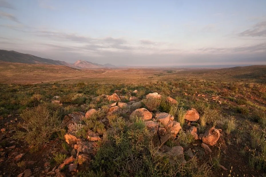
Photos of the Karoo Desert


Physical Features
Area: Approximately 400,000 km² in broad geographic use; the Karoo has no single universally fixed boundary
Main Geographic Divisions: Great Karoo and Little Karoo
Terrain: Interior plateaus, broad plains, flat-topped hills, escarpments, mountain basins, and dry river systems
Elevation: Highly variable; much of the Nama Karoo lies between about 500 and 2,000 m, while large parts of the Succulent Karoo are below 800 m
Climate & Precipitation
Temperature: Hot summers are common across much of the interior; winters can bring frost and snow on higher ground
Precipitation: Strongly variable by location; the Nama Karoo generally receives about 100–520 mm annually, mainly in summer, while the Succulent Karoo receives about 20–290 mm, mainly in winter
Ecological Features
Biogeographic Realm: Afrotropical
Major Biomes: Nama Karoo and Succulent Karoo, which are separate South African biomes with different rainfall patterns and vegetation
Vegetation Structure: Dwarf shrubland, sparse grassland, succulent shrubland, rocky-slope vegetation, and dry river vegetation
Flora & Fauna
Flora: Nama Karoo vegetation is dominated by dwarf shrubs and grasses, while the Succulent Karoo supports dense concentrations of leaf succulents, annuals, geophytes, and low shrubs
Fauna: Springbok, gemsbok, Cape mountain zebra, meerkat, bat-eared fox, aardwolf, caracal, riverine rabbit, ostriches, larks, raptors, reptiles, and many smaller arid-zone species occur in different parts of the wider Karoo
Geology & Notable Features
Geology: Sedimentary rocks of the Karoo Supergroup, including mudstone, shale, sandstone, and older glacial deposits, are cut in many places by resistant Jurassic dolerite sills and dykes
Notable Features: Karoo fossil beds, Karoo National Park, Valley of Desolation, Tankwa Karoo National Park, the Great Escarpment, and the Swartberg Mountains
Geography
The Karoo covers roughly 400,000 square kilometers under a broad geographic definition, although no single boundary is accepted for every scientific or administrative purpose. It extends across a large part of South Africa’s central and western interior.
The Great Karoo lies mainly north of the Swartberg and includes broad interior plains, mesas, flat-topped hills, and escarpment landscapes. The Little Karoo, or Klein Karoo, occupies a narrower basin south of the Swartberg and north of the Langeberg and Outeniqua ranges.
These geographic divisions should not be confused with the Nama Karoo and Succulent Karoo, which are vegetation biomes. Their boundaries do not follow the Great Karoo and Little Karoo divisions exactly.
Climate
The Karoo does not have a single rainfall regime. Climate changes across the region, and the two main Karoo biomes differ sharply in the timing of precipitation.
The Nama Karoo occupies much of the central plateau. SANBI records annual rainfall of about 100–520 mm, falling mainly during summer. Rainfall becomes generally lower toward the west, while grasses tend to become more common where summer rainfall is greater.
The Succulent Karoo lies mainly west and southwest of the Nama Karoo. It receives approximately 20–290 mm annually, with most precipitation associated with winter rainfall systems. Summers are very dry, and temperatures above 40°C can occur.
Winter frost is common in higher parts of the interior, and snow occasionally falls on mountain peaks and elevated escarpment areas.
Flora and Fauna
Plant communities vary strongly across the Karoo. There is no single plant species called the “Karoo bush” that defines the whole region.
In the Nama Karoo, dwarf shrubs and grasses dominate much of the landscape. Grass cover is often greater on sandy soils and in areas receiving more summer rainfall, while shrubs become more prominent in drier or heavily grazed areas.
The Succulent Karoo has a different vegetation structure. Dwarf succulent shrubs are especially prominent, including many members of the Aizoaceae and Crassulaceae families. Annual wildflowers and geophytes can become conspicuous after favorable winter rainfall.
Animal communities also change between habitats. Species recorded in Karoo landscapes include:
- Springbok – Widespread in open dry country and regularly seen in protected areas such as Karoo National Park.
- Gemsbok – Present in arid and semi-arid habitats, including Karoo National Park.
- Cape Mountain Zebra – Found in protected mountain and plateau habitats within the wider Karoo region.
- Bat-eared Fox and Cape Fox – Small carnivores associated with open dry landscapes.
- Meerkat – Occurs in suitable arid habitats in parts of the Karoo.
- Riverine Rabbit – A threatened Karoo endemic associated with riverine vegetation in parts of the Nama Karoo.
Conservation Areas
Protected areas conserve different parts of the Karoo rather than one uniform desert ecosystem. Karoo National Park near Beaufort West protects Nama Karoo vegetation, escarpment terrain, wildlife, and fossil-bearing geology. Mammals recorded there include springbok, gemsbok, Cape mountain zebra, black rhinoceros, brown hyena, lion, meerkat, bat-eared fox, and riverine rabbit.
Farther west, Tankwa Karoo National Park protects very dry landscapes near the transition between Nama Karoo and Succulent Karoo environments. Other reserves protect mountain, riverine, succulent, and steppe habitats elsewhere in the region.
Grazing pressure, invasive plants, changes to water systems, infrastructure, mining, and climate variability affect different Karoo landscapes in different ways.
Comparison with Other Deserts
| Region | Location | Approx. Area | Rainfall Pattern | Landscape Character |
|---|---|---|---|---|
| Karoo | South Africa | ~400,000 km² under a broad geographic definition | Summer-dominant in Nama Karoo; winter-dominant in Succulent Karoo | Semi-arid plateaus, shrublands, grass-shrub mosaics, succulent landscapes, and mountain basins |
| Sahara Desert | North Africa | ~9,200,000 km² | Extremely low and irregular across much of the interior | Sand seas, gravel plains, rocky plateaus, basins, and mountains |
| Gobi Desert | Mongolia and China | ~1,295,000 km² | Low precipitation with strong continental seasonality | Gravel plains, basins, rocky terrain, and dune fields |
| Atacama Desert | Chile | ~105,000 km² | Extremely low across the hyper-arid core | Salt flats, gravel surfaces, high plateaus, and volcanic terrain |
Geology and Fossil Record
Much of the Karoo is underlain by rocks of the Karoo Supergroup. In Karoo National Park, the exposed sequence includes rocks of the Beaufort Group above the Ecca Group, with mudstone, siltstone, shale, and sandstone cut by resistant dolerite intrusions.
The wider Karoo Basin contains one of the best-known terrestrial fossil records from the late Paleozoic and early Mesozoic. Fossil-bearing Beaufort Group rocks preserve abundant therapsids, a group that includes extinct relatives on the evolutionary line leading toward mammals. The Gats River fossil bed near Nieu-Bethesda is one of the productive sites in this record.
Karoo National Park also maintains a Fossil Trail displaying fossils and petrified wood from the region.
People and Land Use
Human history in the Karoo extends far beyond modern farming towns. San hunter-gatherers and Khoekhoe pastoralists lived across parts of southern Africa, including landscapes now associated with the Karoo, before large-scale colonial settlement.
From the eighteenth and nineteenth centuries onward, extensive livestock farming became a major land use across much of the region. Sheep and goats remain closely associated with the Karoo economy, while towns such as Beaufort West, Prince Albert, Graaff-Reinet, and others developed as service and transport centers within the dry interior.
The ǂKhomani San are associated primarily with the southern Kalahari and should not be used as a representative present-day community for the Karoo.
Karoo in Regional Context
The Karoo is best understood as a large semi-arid region containing several geographic and ecological systems rather than as one uniform desert. The Great Karoo and Little Karoo are geographic divisions, while the Nama Karoo and Succulent Karoo are separate biomes with different rainfall regimes and plant communities.
Its sedimentary basins and dolerite-capped landscapes preserve an extensive fossil record, while present-day shrublands, grasslands, succulent vegetation, livestock farms, small towns, and protected areas occupy the same broad region. These differences explain why a single rainfall figure, vegetation type, or wildlife list cannot accurately describe the whole Karoo.
References
South African National Biodiversity Institute – Nama Karoo Biome
South African National Biodiversity Institute – Succulent Karoo Biome
SANParks – Karoo National Park Geology
SANParks – Karoo National Park Climate
SANParks – Karoo National Park Mammals
SANParks – Karoo National Park Fossil Trail
South African Heritage Resources Agency – Gats River Fossil Bed
South African Government – Great Karoo and Little Karoo Regional Overview
BirdLife South Africa – Birds of the Karoo: Ecology and Conservation