Location and Continent
The Cholistan Desert sits in South Asia, spread across southern Punjab, Pakistan, mainly within the Bahawalpur Division. It lies along the western reach of the Greater Thar Desert, where dry sands and old river traces meet like two pages of the same long story.
Continent: Asia
Country: Pakistan
Province/Region: Punjab (Bahawalpur, Bahawalnagar, Rahim Yar Khan districts)
Local Name: Rohi
Approximate Coordinates (Range): 27°42′–29°45′N, 69°52′–73°05′E
Nearest Major City: Bahawalpur (edge of the desert is roughly 30 km away)
Cholistan Desert – Map Embeds
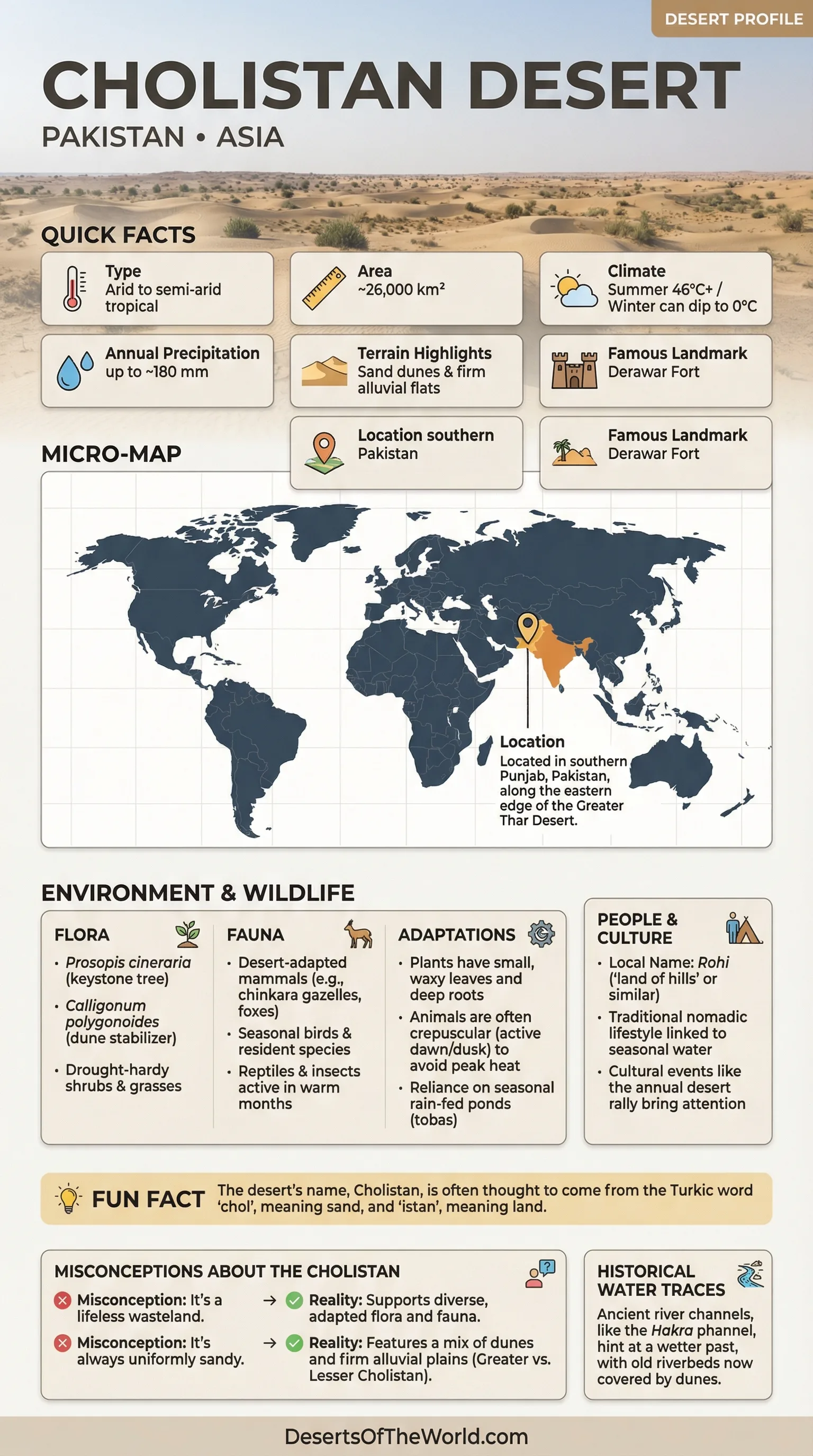
Photo: The Cholistan Desert
Physical Features
Think of the Cholistan Desert as a wide, quiet ocean where the waves are made of sand instead of water. Some parts roll in low dunes. Other parts flatten into firm, pale plains that feel almost like an outdoor floor.
Area: ~25,800–26,330 km²
Length: ~480 km
Width: ~32–192 km
General Elevation: often around ~110 m above sea level (varies locally)
Surface Mix: roughly sand-dominant terrain with notable alluvial flats in places
| Cholistan Region | Typical Ground | Vegetation Feel | Water Pattern |
|---|---|---|---|
| Greater Cholistan | Deep sand, dunes, loose surfaces | Drought-hardy shrubs and grasses, scattered trees | Seasonal rain-fed ponds (tobas) matter most |
| Lesser Cholistan | More firm plains, mixed soils | More continuous cover in patches, especially near managed lands | Water access tends to be less distant than deep-sand zones |
Climate and Rainfall
The Cholistan Desert runs on big contrasts. Days can feel like a sunlit furnace, then the air cools fast after dark. The sky is often clear, which means heat escapes quickly at night.
Climate Type: Arid to semi-arid tropical desert
Summer Highs: commonly 46°C+, and occassionally higher during harsh heat spells
Winter Lows: can dip toward 0°C on cold nights
Average Annual Rainfall: often up to ~180 mm, with most rain tied to July–August monsoon influence
- Humidity: typically low, so heat can feel sharp and dry.
- Winds: shifting air shapes dunes and moves fine sand like powder across the surface.
- Rainfall Style: short, irregular bursts rather than steady wet seasons.
Ecological Setting
Life in the Cholistan Desert is built on restraint. Plants and animals behave like careful savers, spending water slowly and using shade like it is currency. The dominant biome is deserts and xeric shrublands, closely linked to the broader Thar Desert ecological region.
A notable protected landscape near the desert’s edge is Lal Suhanra, recognized internationally as a Biosphere Reserve. Its mix of desert, forest, and wetland habitats helps show how varied the Cholistan margin can be.
Flora and Fauna
Plants That Match The Desert’s Rhythm
The Cholistan Desert supports plant communities that look modest at first glance, then impressive once you notice the details: tiny leaves, waxy skins, deep roots, and seeds that wait patiently for the right rain. Many species are adapted to brackish conditions and long dry gaps.
- Prosopis cineraria (a keystone desert tree in many Thar-region landscapes)
- Calligonum polygonoides (a dune stabilizer in sandy stretches)
- Acacia nilotica and Tamarix species in suitable pockets
- Ziziphus shrubs and hardy grasses in rangeland mosaics
- Communities often described by dominant species such as Haloxylon, Tribulus, and other arid-zone specialists
Wildlife Adapted To Heat and Open Space
Animal life in the Cholistan Desert leans toward cool-hour activity. Many creatures feed at dawn, rest in shade, then move again near sunset. This is desert logic: avoid the hottest hours, keep energy costs low, and stay alert in open terrain.
- Desert-adapted mammals: gazelles such as chinkara in suitable habitats, small foxes, hares, and hedgehogs in open scrub
- Birdlife: seasonal visitors and resident species that use open plains, shrubs, and water points
- Reptiles and insects: important parts of the food web, often seen in warm months on sandy tracks and firm flats
Several zones connected to the Cholistan Desert are managed for wildlife, where habitat protection supports a calmer, more stable environment for native species.
Geology and Landscape History
The ground of the Cholistan Desert holds clues to older climates. Beneath today’s sand are signs of former river influence and shifting wind regimes. It is not one single landscape; it’s a patchwork built over time.
A key piece of the story is the ancient Hakra (often discussed within the broader Ghaggar-Hakra paleochannel system). Old channels and settlement traces in the wider region hint at periods when water shaped the land more strongly than it does now. In places, dunes sit like blankets over older surfaces, softening the outlines without erasing them.
- Sand seas and dune fields: wind-built forms that migrate slowly over years
- Alluvial flats: firmer ground where fine sediments collect
- Salt-tinged patches: where evaporation concentrates minerals near the surface
Introduction To The Cholistan Desert
The Cholistan Desert is one of those places that looks simple from far away, then gets more interesting with every step. It stretches across southern Punjab as a broad golden-brown expanse, known locally as Rohi. Even its name carries a clue: often explained as coming from chol (“sand”) with -istan (“land”), a compact label for a vast terrain.
Many deserts are introduced with big dune photos. Cholistan deserves that, sure, but it also deserves a quieter description: space, long horizons, and land that shifts between soft sand and firmer plains. It feels like a landscape that speaks in short sentences.
Geography Of Sand, Flats, and Boundaries
The Cholistan Desert lies near the meeting point of several desert-and-river-influenced regions. It connects naturally to the wider Thar system, and its margins reflect how deserts often behave: not with a single hard border, but with a gradual change in soil, plants, and water access.
One commonly used way to understand the Cholistan Desert is to see it as two broad character zones. Greater Cholistan is more dune-driven, where sand dominates the surface. Lesser Cholistan includes more mixed ground and firmer plains. The transition can be subtle, like walking from carpet to tile without noticing the exact step where it changed.
Water In A Land That Rarely Gives It Away
Water shapes every decision in the Cholistan Desert, even when it’s out of sight. Rain arrives unevenly, and much of the year is dry. So the region leans on clever storage traditions and local geography.
Seasonal rainwater is often collected in ponds called tobas, which become vital nodes across the sandy network. In some areas, water may also be stored in built ponds or tanks known locally as kunds. Groundwater can exist at depth, yet it is frequently salty or brackish, limiting its use for many plants.
This is why the Cholistan Desert can feel like a place where water is both present and absent at the same time. You can stand on dry sand and still be near a life-saving water point, hidden by distance or low relief.
How Heat and Wind Shape Daily Ecology
The Cholistan Desert is sun-led. Summer heat can be intense, and the light has a bright, clean edge. Wind does the slow construction work: lifting grains, smoothing ridges, and nudging dunes into new shapes one season at a time.
Temperature swings are part of the desert’s identity. Warm days, cooler nights. Dry air, then brief monsoon humidity. These shifts create a pattern that local ecosystems understand well. The land looks still, yet it’s always adjusting.
Vegetation Strategies: Tough Leaves, Patient Seeds
Plant life in the Cholistan Desert is a masterclass in efficiency. Many shrubs keep leaves small, or drop them when stress is high. Some grasses respond quickly after rain, greening the ground in a short-lived but striking burst.
Certain species also help hold the desert in place. Shrubs like Calligonum can stabilize dunes, while trees such as Prosopis cineraria can offer shade, micro-habitat, and a sense of structure in open terrain. A single tree out here can feel like a small building.
Wildlife Patterns: Morning, Shade, and Evening
In the Cholistan Desert, survival often means timing. Many animals reduce midday movement and use shade, burrows, or vegetation cover. Then the landscape wakes again in the cooler hours.
Mammals such as gazelles in suitable habitats, small foxes, and desert hares match the open space with alert movement. Birds add another layer, with seasonal visitors appearing when conditions suit them. The desert can look empty at noon, then lively at dawn.
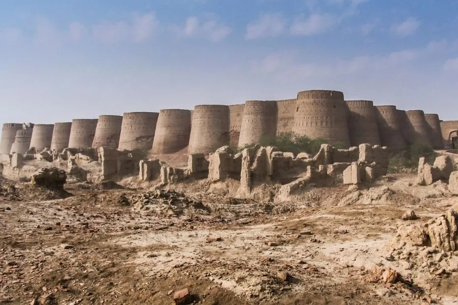
Derawar Fort and Cultural Landmarks
The Cholistan Desert is also a landscape of human memory. One of its most striking landmarks is Derawar Fort, a massive square fortress whose bastions rise above the flat sands like a ship on a calm sea.
The wider region includes heritage sites tied to older settlement patterns and trade routes, plus living traditions expressed through crafts, music, and community gatherings. Modern events—like the well-known desert rally held in the region—often bring new attention to Rohi without changing its core character: vast, quiet, and proud.
- Derawar Fort: iconic fortress architecture set within the desert landscape
- Lal Suhanra Area: an internationally recognized biosphere reserve near the desert’s edge
- Desert Settlements and Water Points: small nodes that define movement across open land
Research and Stewardship In The Desert
The Cholistan Desert is closely studied because it represents many themes shared by arid lands worldwide: water scarcity, heat stress, and the delicate balance between grazing lands and vegetation cover. Local institutions, including university-based desert research centers, focus on practical science—soil, plants, water harvesting, and sustainable land use.
Stewardship here often looks simple on the surface: stabilize dunes, protect key habitats, improve water storage, and support resilient vegetation. Simple doesn’t mean easy. Yet small, steady actions can matter a lot in dryland environments.
Sources
Tourism, Archaeology and Museums Department Punjab – Derawar Fort (Cholistan)
The Islamia University of Bahawalpur – Cholistan Institute of Desert Studies
Government of Punjab (Bahawalpur) – Lal Suhanra National Park
UNESCO – Lal Suhanra Biosphere Reserve (Cholistan Margin)
Salam Pakistan (PTDC, Government of Pakistan) – Cholistan
University of the Punjab (Journal PDF) – Rainfall Variation and Rainwater Harvesting Context for Cholistan (Rohi)
PCRWR (Government of Pakistan) – The Lifeline of Cholistan Desert (Water Context)
Cholistan Desert – Wikipedia (Background Overview)