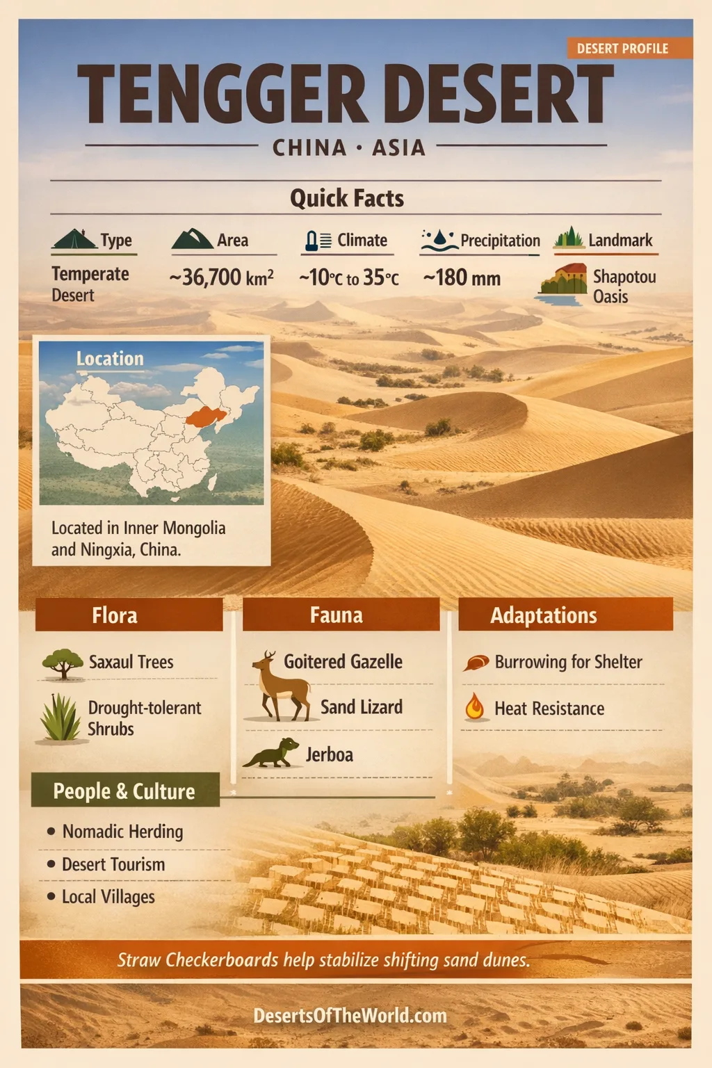
Location & Continent
Continent: Asia
Country: China
Primary Regions: Inner Mongolia (Alxa League), Ningxia, Gansu
Approximate Coordinates (Center Point): 38°42′N, 104°42′E
Commonly Cited Area: ~36,700 km² (broader definitions can place it above 40,000 km²)
Average Elevation: ~1,400 m
Desert Type: Temperate Sand Desert at the East Asian monsoon margin
Tengger Desert – Map
Photos Of The Tengger Desert
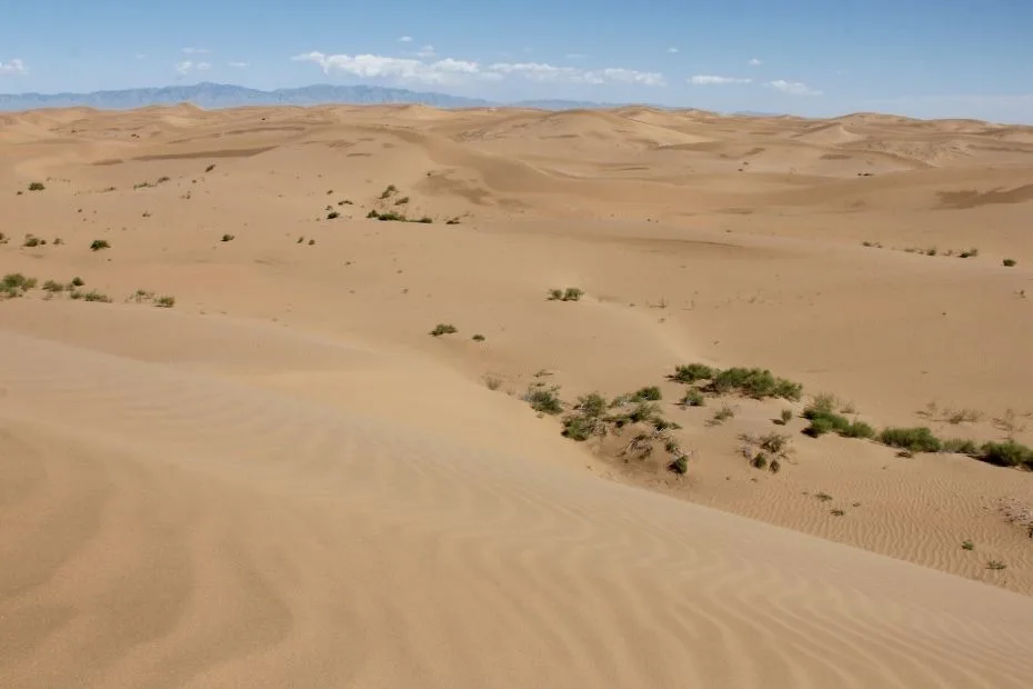
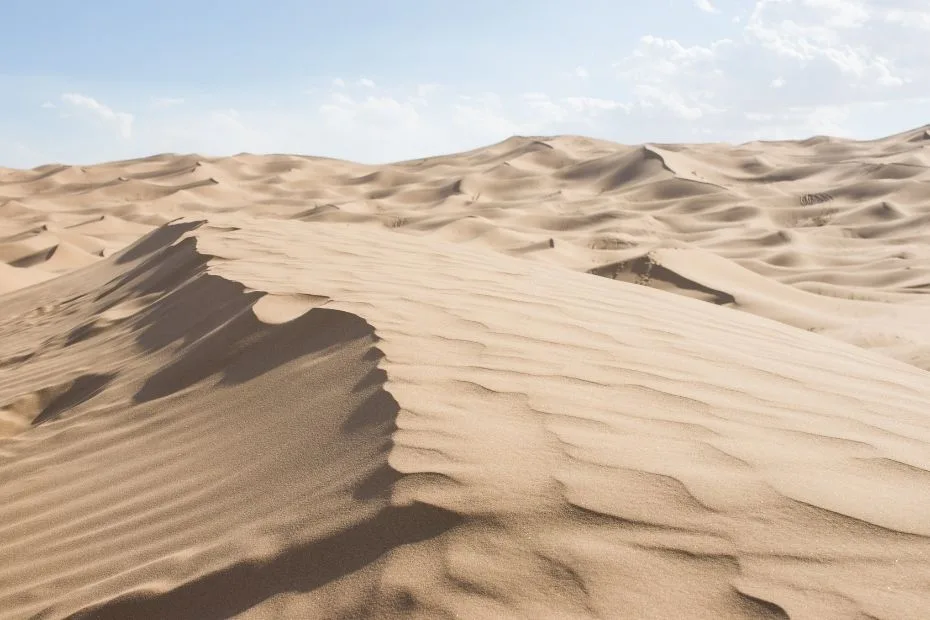
- Rippled dunes that look like frozen waves under low sun, with long shadows.
- Interdune basins showing salt flats and pale crusts, often framed by low shrubs.
- Shapotou edge landscapes where sand meets oasis in a sharp line of green.
- Straw checkerboard grids that turn moving sand into a stable pattern, like stitched fabric across dunes.
Physical Features
Core Landforms: sand seas, dune ridges, interdune corridors, and pockets of gravelly surfaces
Typical Dune Character: From low ripples to tall ridges that can rise tens of meters above surrounding basins
Notable Edge Zone: Shapotou sits on the southeastern fringe, a place where oasis, dunes, and river-influenced landscapes meet
Climate & Weather Patterns
The Tengger Desert runs on a continental rhythm: bright days, crisp nights, and big temperature swings. Rain is limited, yet not absent. Much of what does arrive tends to fall in the warm season near the monsoon edge, while the rest of the year stays very dry.
Representative Climate Snapshot (Southeastern Edge Near Shapotou)
| Climate Detail | Typical Value | Why It Matters In A Sand Landscape |
|---|---|---|
| Annual Mean Temperature | ~10°C | Supports a short growing season and strong seasonal contrast |
| Coldest Mean Month | ~ -6.9°C (January) | Winter cold slows biology, leaving bare sand exposed |
| Warmest Mean Month | ~ 24.3°C (July) | Heat boosts evaporation; plants rely on efficient water use |
| Annual Precipitation | ~186 mm | Enough for shrub-steppe edges, not enough to stop dunes without stabilization |
| Rainfall Seasonality | ~80% falls May–September | Short wet pulses can trigger quick green-up |
| Sunshine Hours | ~2,730 hours/year | High radiation increases drying power of the air |
| Typical Wind Speed | ~2.9 m/s | Wind is the desert’s sculptor, shaping dunes grain by grain |
Ecological Setting
The Tengger Desert is not a single, uniform “blank” of sand. It is a mosaic of dune fields, sparse vegetation zones, and dry basins. On its margins, especially near places like Shapotou, the desert blends into desert-steppe landscapes where shrubs and hardy herbs hold ground in a tough enviroment.
Landscape Units Often Seen Across The Region
- Mobile dunes where sand is loose and wind-driven, with rapid surface change.
- Fixed or semi-fixed dunes where shrubs, litter, and soil crusts create stability.
- Saline flats and playas that form pale “floors” between dunes, often edged with salt-tolerant plants.
- Gravelly or stony patches that behave more like hard ground than sand, adding texture to the desert map.
Flora & Fauna
Plant life here is built around water discipline. Many species keep leaves small, waxy, or seasonal, and use deep roots or flexible growth to survive. Along the monsoon-edge zones, a surprising range of seed plants has been recorded, with hundreds of species reported across the wider desert region.
Plants Commonly Linked With The Tengger’s Edges
- Reaumuria soongorica and Salsola passerina in shrub communities, often forming low, wind-shaped mounds with patchy cover.
- Artemisia species in sandy soils, acting like living anchors for surface grains, with strong drought tolerance.
- Caragana shrubs on transition zones, supporting micro-habitats where wind and heat feel slightly softer.
- Haloxylon, Nitraria, and Calligonum in many restoration and ecotone studies, valued for sand-fixing ability and stress resilience.
Animal Life In A Sand-First World
Wildlife tends to be low-profile and efficient. Small mammals, reptiles, and insects often use burrows or crevices as natural climate control. Birds appear where food and water concentrate, especially near oases and vegetated edges. The pattern is consistent: life follows shade, shelter, and timing, not brute strength.
Biological Soil Crusts: The Quiet Builders
In stabilized areas, the ground can develop a thin living skin known as a biological soil crust. It may include cyanobacteria, lichens, and mosses, binding grains together like natural glue. This crust can reduce surface erosion and help early soil formation, changing how water soaks in after rare rain.
Geology & Landscape Formation
The Tengger Desert is shaped by a long partnership between wind and sediment supply. Sand here is largely Quaternary in age at the surface, with grains moved, sorted, and stacked into dunes over time. Nearby mountain belts and uplands contribute material that wind can rework into the desert’s familiar ridges and basins.
Why Dunes Keep Their Forms
Dunes are not random piles. They organize under repeating wind directions, shifting like a slow tide. Where vegetation takes hold, dune faces can “lock,” and the landscape starts to behave more like terrain than drifting sand. It’s geology in motion, then geology at rest.
Desert Lakes And Ancient Shorelines
Parts of the Tengger region hold evidence of older, wetter phases, including paleolake history often discussed under the name Lake Tengger. Ancient shore features hint that basins once held far more water than today, leaving behind terraces and deposits that contrast sharply with modern aridity.
Introduction To The Tengger Desert
The Tengger Desert (also called Tengri Desert) is often translated as the “Sky Desert”, a name that fits its open horizons. It sits in north-central China, mostly within Inner Mongolia’s Alxa region, and stretches toward Ningxia and Gansu. It is widely described as one of China’s largest deserts, known for a clean dune aesthetic and a strong research history in sand stabilization.
Where The Tengger Fits In Asia’s Drylands
Think of the Tengger as a hinge zone between broader arid interiors and the outer reach of monsoon influence. This position matters. In summer, moisture can push inland in limited bursts, while the rest of the year favors dry air and evaporation. The result is a desert that can support shrub communities on its edges, yet still preserves wide sand seas that feel purely aeolian.
Within Inner Mongolia, the Tengger connects conceptually to a larger desert network. UNESCO’s Alxa Desert UNESCO Global Geopark even identifies a Tengger geo-region as part of the area’s major geoheritage, placing the desert in a broader story of landforms, sediments, and long-term landscape evolution.
Shapotou And The Science Of Holding Sand Still
On the Tengger’s southeastern edge, Shapotou stands out as a famous boundary where dunes press close to human corridors. This is where sand control became a practical craft, not just a theory. A key symbol is the straw checkerboard: squares of straw placed partly into the sand to reduce wind speed at the surface and encourage sand settling. The pattern looks simple, almost playful, yet it works like a net catching grains.
The Shapotou Desert Research and Experiment Station, founded in the mid-20th century, is closely linked to this work. Monitoring there has included wind, rain, soil moisture, and vegetation recovery, building a knowledge base for desert restoration that has become widely referenced in arid-land research.
What Makes The Tengger Desert Visually Distinct
The Tengger often feels clean-lined. Dunes form long ridges, and the spacing between them can create corridors that read like natural streets. At sunrise or late afternoon, the desert surface turns into a study of light geometry: sharp crests, smooth lee slopes, and ripple marks that resemble fingerprints pressed into sand.
Interdune areas can shift the mood fast. Some basins show salt crusts and pale soils; others hold sparse plants that cast small shadows, each one a sign of micro-water access below the surface. The contrast between moving sand and anchored life is part of the Tengger’s signature.
Water: Rare, Local, And Surprisingly Influential
In deserts, water doesn’t need to be abundant to matter. In the Tengger, moisture appears through seasonal rainfall pulses, shallow groundwater in select zones, and occasional surface water in basins. Even when lakes are small or saline, they can shape nearby microclimates and create islands of vegetation.
The region’s paleolake history adds depth to the story. When climates were different, basins could hold much larger waters, leaving behind shore features that read like old coastlines in a place that now looks far from any sea. It’s a reminder that today’s dunes are a chapter, not the whole book.
Restoration: From Patterns To Living Cover
Stabilizing sand is often a step-by-step process. First comes surface roughness to break wind flow, then plant establishment, then the slow build of soil properties and biological crust. In places like Shapotou, the combination of checkerboards, shrubs, and long-term monitoring has shown how a desert surface can transition from mobile dunes to semi-fixed land with measurable ecological function.
Research in the broader Tengger region also examines how shrubs regulate water use, how soils change after stabilization, and how restored areas function across seasons. Results indicate that desert systems perform more effectively when restoration methods align with local climate, sediment conditions, and native plant characteristics.
References
Tengger Desert (Overview, Area, Coordinates)
UNESCO: Alxa Desert UNESCO Global Geopark (Tengger Geo-Region)
NASA Earth Observatory: Dust Storm In The Tengger Desert
NASA Visible Earth: Dust Storm In Tengger Desert (Image Background)
NASA MODIS Gallery: Snow On The Eastern Tengger Desert (Jan 2025)
ChinaFLUX: Shapotou Site Description (Climate And Vegetation Context)
DEIMS-SDR: Shapotou Desert Research And Experiment Station (Site Data)
China State Council (English): Sand Control Work Linked With Shapotou Station
Journal Of Desert Research: Vegetation Characteristics Of The Tengger Desert
Straw Checkerboard Technique (Background And Origin In Shapotou)