Africa holds the largest hot desert on Earth, a fog-fed coastal desert, chalk badlands, salt pans, lava fields, fossil lake beds, and dry basins that blur the line between desert, semi-desert, and arid steppe. That variety is the real story. Too many overviews treat African deserts as a short list headed by the Sahara, then move on. The map is much richer than that.
Atlantic Coastal Desert
Location & Continent Continent: Africa Countries / Regions: Mauritania, Western Sahara (region) Desert System: Western Sahara Edge of...
Read More →Sinai Desert
Location and Regional Context Continent: Asia (Western Asia) Country: Egypt Region: Sinai Peninsula Central Coordinates: 29.50°N, 33.83°E The...
Read More →Bayuda Desert
Location & Continent Continent: Africa Country: Sudan Region: Northeastern Sahara / Eastern Sahara Setting: Inside the Great Bend...
Read More →Nubian Desert
Location & Continent Continent: Africa Region: Eastern Sahara / Northeast Africa Countries: Sudan, Egypt Core Position: Between the...
Read More →Eastern Desert
Location And Continent The Eastern Desert is a wide belt of arid land on Africa’s northeast edge, stretching...
Read More →White Desert National Park
Location & Setting The White Desert is a chalk-sculpted landscape in Egypt’s Western Desert, closely tied to the...
Read More →Libyan Desert
Libyan Desert Location & Continent Continent: Africa Region: Eastern Sahara Countries: Libya, Egypt, Sudan Approximate Coordinates: 25°N, 25°E...
Read More →Tin-Toumma Desert
Location and Continent The Tin-Toumma Desert is a vast dune plateau in southeastern Niger, set along the Sahel–Sahara...
Read More →Djurab Desert
Djurab Desert Location & Continent The Djurab Desert is a broad Sahara landscape in northern Chad, set in...
Read More →El Djouf
Location and Setting El Djouf is a hyper-arid desert region on the western edge of the Sahara, stretching...
Read More →Tanezrouft
Location & Continent Continent: Africa Countries: Algeria, Mali Region: Tanezrouft (part of the Sahara Desert) Approximate Coordinates: 22.251°N,...
Read More →Ténéré Desert
Location & Continent Continent: Africa Countries: Niger, Chad Region: South-central Sahara Desert, between the Aïr Mountains and the...
Read More →Eritrean Coastal Desert
Location & Continent Continent: Africa Countries: Eritrea, Djibouti Coordinates (approx.): 13°N, 42°E – along the southern Red Sea...
Read More →Lompoul Desert
Location & Continent Continent: Africa Country: Senegal Coordinates: 15°55′N, 16°40′W Photos of the Lompoul Desert Physical Features Area:...
Read More →Nyiri Desert
Location & Continent Continent: Africa Country: Kenya Coordinates: 2°S, 36°E Physical Features Area: ~15,000 km² Elevation: Varies between...
Read More →Chalbi Desert
Location & Continent Continent: Africa Country: Kenya Coordinates: 3°30′N, 37°30′E Photos of the Chalbi Desert Physical Features Area:...
Read More →Grand Bara Desert
Location & Continent Continent: Africa Country: Djibouti Coordinates: 10°30′N, 42°55′E Photos of the Grand Bara Desert Physical Features...
Read More →Guban Desert
Location & Continent Continent: Africa Country: Somalia (Somaliland region) Coordinates: 10°30′N, 45°00′E Physical Features Area: Narrow coastal desert...
Read More →Danakil Desert
Location & Continent Continent: Africa Countries: Ethiopia, Eritrea, Djibouti Coordinates: 13°N, 40°E Photos of the Danakil Desert Physical...
Read More →Kalahari Desert
Location & Continent Continent: Africa Countries: Botswana, Namibia, South Africa, Angola, Zambia, Zimbabwe Coordinates: 23°S, 22°E Photos of...
Read More →Karoo Desert
Location & Continent Continent: Africa Country: South Africa Coordinates: 30°S, 22°E Photos of the Karoo Desert Physical Features...
Read More →Namib Desert
Location & Continent Continent: Africa Countries: Namibia, Angola, South Africa Coordinates: Approximately 23°S, 15°E Photos of the Namib...
Read More →Sahara Desert
Location & Continent Continent: Africa Countries: Algeria, Chad, Egypt, Libya, Mali, Mauritania, Niger, Western Sahara, Sudan, Morocco, Tunisia...
Read More →23 inventions in Africa
A practical definition helps. In physical geography, a desert usually receives less than 250 millimetres of rain a year, but rainfall alone does not explain everything. Fog moisture, cold ocean currents, rain shadows, rift tectonics, and old river or lake systems shape how a desert looks and works. That is why the Namib behaves differently from the Danakil, why the Kalahari supports more grass than the Libyan Desert, and why the White Desert is pale chalk rather than red sand.
Another point matters: this pillar page covers both full continental deserts and named desert subregions. That is not a mistake. On the African map, many famous drylands are nested inside larger systems. The White Desert sits inside Egypt’s Western Desert, which itself is part of the Sahara. The Bayuda Desert lies inside the great arid arc of northeastern Sudan. The Ténéré is one of the Sahara’s great sand plains. Scale changes the reading. A reader who only knows the giant names misses how the continent’s drylands actually connect.
This page counts 23 African deserts by combining: continent-scale deserts, widely recognized sub-deserts, coastal desert ecoregions, and small but distinct arid landscapes. A few boundaries vary by source, so area and rainfall figures are best read as approximate working values, not survey-grade borders.
What Counts as a Desert in This Pillar Page
To make the list useful, not just long, the 23 entries below follow a simple logic. Each one is a named arid landscape with clear geographic identity, scientific interest, or long-established regional use. Some are huge. Some are compact. One is technically in the Sinai Peninsula, a land bridge between Africa and Asia, but it belongs in an African desert discussion because it is part of Egypt’s desert geography and connects directly with the Red Sea and northeastern Sahara dry belt.
- Continental anchors: Sahara, Kalahari, Namib, Karoo.
- Large Sahara sectors: Libyan Desert, Eastern Desert, Nubian Desert, Ténéré, Tanezrouft.
- Smaller Sahara units: White Desert, Bayuda, Djurab, El Djouf, Tin-Toumma, Atlantic Coastal Desert.
- Horn and Red Sea drylands: Danakil, Eritrean Coastal Desert, Grand Bara, Guban, Sinai Desert.
- Localized dry basins: Chalbi, Nyiri, Lompoul.
This wider lens fixes a common content gap. Many “African deserts” pages stop after eight or nine names and leave out the smaller places where geology gets more precise and more interesting: the chalk towers of the White Desert, the basalt cones of Bayuda, the fog belt of the Atlantic Coastal Desert, or the salt-and-clay plain of Chalbi. Those places are not filler. They are how Africa’s desert systems become legible.
Why Africa Has So Many Desert Types
Four controls explain most of the continent’s dryland pattern. First comes the subtropical high-pressure belt, which pushes dry descending air over North Africa and parts of the south. That is a main reason the Sahara is so broad and why southern Africa has the Kalahari and the Karoo.
Second comes the ocean. The cold Canary Current helps dry the Atlantic edge of the Sahara, while the cold Benguela Current helps build the Namib. These are not rainy coasts. They are coasts where cool water stabilizes the lower atmosphere, reduces convection, and turns moisture into fog more often than rain. That is why some coastal deserts can feel damp in the air while staying bone-dry in the ground.
Third comes relief. Mountains can strip moisture from moving air and leave a rain shadow on the far side. The Nyiri Desert in Kenya owes much of its dryness to the shadow of Mount Kilimanjaro. The Red Sea Hills, the Sinai uplands, and local escarpments across East Africa and the Sahara also shape runoff, wadis, and short-lived storms.
Fourth comes deep time. Africa’s deserts are not just “sand places.” They include rift basins, evaporite flats, sand seas, rock plateaus, playas, fossil lake beds, and karst-like chalk landscapes. The Danakil is tied to active crustal stretching. The White Desert comes from marine sediment later carved by wind. The Chalbi preserves the memory of an old lake. The Bayuda carries a volcanic signature inside a larger desert setting. Same continent, very different desert mechanics.
One broad statistic helps frame the scale: deserts cover nearly 40% of Africa when mapped at ecosystem level. Yet only part of that area is made of classic dune seas. A large share is gravel plain, stony desert, plateau, salt flat, or semi-arid sandy savanna. So yes, Africa is a desert continent in a big geographic sense, but not in a one-shape-fits-all way.
Core Desert Data
Figures below are approximate. Some named deserts are sharply bounded protected areas or ecoregions; others are broader natural regions with softer edges.
| Desert | Main Setting | Countries or Region | Approx. Area or Scale | Typical Dryness Signal | Standout Trait |
|---|---|---|---|---|---|
| Atlantic Coastal Desert | Coastal ecoregion on Sahara edge | Mauritania, Western Sahara region | About 39,000 km² | Often around 30 to 40 mm rain, frequent fog | Canary Current fog belt |
| Sinai Desert | Peninsular desert bridge | Egypt | Sinai Peninsula about 61,000 km² | Very low rain, mostly wadis and plateaus | Africa-Asia transition |
| Bayuda Desert | Inner-Sudan desert inside Nile bend | Sudan | About 140,000 km² | Very dry, sparse wells and wadis | Volcanic field in a desert core |
| Nubian Desert | Eastern Sahara sector | Sudan, Egypt | About 400,000 km² | Usually under 125 mm rain | Rocky sandstone plateau and wadis |
| Eastern Desert | Sahara east of the Nile | Egypt, Sudan belt | About 222,000 to 223,000 km² in Egypt | Often under 25 mm rain | Red Sea Hills and mining wadis |
| White Desert National Park | Protected chalk desert landscape | Egypt | About 3,010 km² protected area | Hyper-arid Western Desert setting | White chalk columns and mushrooms |
| Libyan Desert | Northeastern Sahara block | Libya, Egypt, Sudan | About 1.1 to 1.3 million km² | Some of the driest ground in Africa | Great Sand Sea and depressions |
| Tin-Toumma Desert | Southeastern Niger sand-and-plain desert | Niger | Part of a reserve nearing 100,000 km² | Very low rain, open Saharan habitats | Rare desert wildlife refuge |
| Djurab Desert | Central Saharan basin desert | Chad | About 200,000 km² | Harsh stony aridity | Major fossil-bearing desert |
| El Djouf | Western Sahara desert basin | Mauritania, Mali | Boundary varies | Arid dune and rock-salt country | Broad shallow sedimentary basin |
| Tanezrouft | Waterless Sahara plateau | Algeria, Mali | Regional plateau scale | Near-total absence of water and vegetation | Classic hamada crossing zone |
| Ténéré Desert | Central Sahara sand plain | Niger, Chad | Over 400,000 km² | Extremely dry and sparsely vegetated | Ergs, regs, and UNESCO reserve link |
| Eritrean Coastal Desert | Red Sea coastal ecoregion | Eritrea, Djibouti | About 4,400 km² | Very low rain, hot coastal strip | Bird migration corridor |
| Lompoul Desert | Small local dune desert | Senegal | About 18 km² | Dry dune pocket near coast | Orange dunes in a compact footprint |
| Nyiri Desert | Rain-shadow semi-desert | Kenya | Localized dryland region | Low rainfall due to rain shadow | Kilimanjaro-controlled aridity |
| Chalbi Desert | Salt-clay desert basin | Kenya | Basin about 110 km long | Very low rain, playa conditions | Ancient lake bed east of Turkana |
| Grand Bara Desert | Flat Djiboutian plain desert | Djibouti | Compact local desert | Very arid, broad flat surface | Dusty clay-sand flats |
| Guban Desert | Hot Gulf of Aden coastal plain | Northwestern Somalia | About 240 km long coastal strip | Often around 50 mm rain | Narrow burning coastal belt |
| Danakil Desert | Rift depression desert | Ethiopia, Eritrea, Djibouti | Regional Afar lowland system | Average annual temperatures around 35°C in hottest parts | Salt pans, rifting, hydrothermal fields |
| Kalahari Desert | Semi-arid sandy savanna desert | Botswana, Namibia, South Africa and beyond in basin terms | About 900,000 km² desert, larger basin beyond that | Driest zones under 250 mm rain | Red sand, pans, grass-and-shrub cover |
| Karoo Desert | Dry interior plateau | South Africa | Roughly a third of South Africa in broader regional use | About 50 to 250 mm in driest tracts | Semi-desert plateau with fossil-rich strata |
| Namib Desert | Cool coastal fog desert | Namibia, Angola, South Africa | About 1,900 km long, 50 to 160 km wide | Rain often under 25 mm in core areas | Fog-driven dune ecosystem |
| Sahara Desert | Continental hot desert | North Africa | About 8.6 million km² | Many areas under 100 mm rain | Largest hot desert on Earth |
How to Read Africa’s Desert Map
It helps to think in layers. At the top level sit the Sahara, Kalahari, Karoo, and Namib. Inside or beside them sit named sectors and edge zones: Nubian, Libyan, Eastern, Ténéré, Bayuda, Atlantic Coastal, and more. Then come local desert expressions, where a basin, a protected area, or a sharp climatic boundary creates a smaller but still distinct dryland such as Chalbi, Nyiri, or Lompoul.
This layered reading also solves another common problem. Readers often expect all deserts to be endless dunes. Africa says otherwise. Many of its driest landscapes are hamada (rocky plateaus), reg (gravel plains), playa flats, wadis, salt crusts, or volcanic fields. Dunes matter, of course, but so do dry valleys, escarpments, pans, and old marine deposits. A desert is a climate-landform system, not just a postcard of sand.
Sahara Core and Sahara Edge
Atlantic Coastal Desert
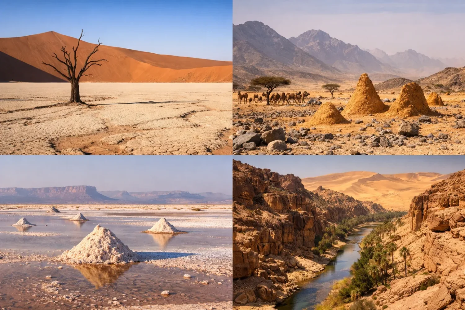
The Atlantic Coastal Desert forms a narrow dry strip along the western edge of the Sahara, especially in Mauritania and the Western Sahara region. On paper it looks like a coast and should perhaps be wetter. In practice, the opposite often happens. The cold Canary Current cools the lower atmosphere, reduces vertical uplift, and limits rainfall. Fog and haze become more common than real showers. In places like Dakhla and Nouadhibou, annual rain can sit around 30 to 40 millimetres, and some years pass with barely any measurable fall at all.
What makes this desert special is its moisture paradox. The air can be humid, the ground still dry. That supports lichens, succulents, and tough shrubs along a coast that would otherwise be almost sterile. Wetlands and coastal flats near the desert edge also matter for birds moving along the East Atlantic Flyway. So this is not just a Saharan fringe. It is a meeting zone between ocean current, fog ecology, migrating birds, and desert landforms. Thin on the map, yes. Ecologically dense, though.
El Djouf
El Djouf sits on the western side of the Sahara in eastern Mauritania and western Mali. It is less famous than the dune seas of Algeria or Niger, yet it matters because it shows how a desert basin works when relief stays low and broad. The terrain includes sand dunes, rocky tracts, and zones with salt-bearing surfaces. Elevation is modest, and the landscape does not rise into a dramatic mountain frame. That quiet topography is part of its identity.
Geographers often describe El Djouf as a shallow sedimentary basin. That phrase sounds technical, but the visual result is easy to grasp: old deposits filling a wide low area, with drainage that has little energy and almost no lasting surface water. Deserts like this do not rely on spectacle. They express dryness through scale, sparseness, and monotony. And that matters for a pillar page, because African desert knowledge gets stronger when the subdued places are included, not only the headline ones.
Tanezrouft
Tanezrouft, spread across southern Algeria and northern Mali, is one of the Sahara’s most severe dry regions. It is not famous because of giant star dunes or unusual colors. It is famous because it is waterless, landmark-poor, and minimally vegetated. Much of it is hamada and stony plateau country rather than a soft sand sea. This difference matters. Rocky desert heats hard, offers little shade, and stores even less accessible moisture than some dune landscapes do.
Older caravan routes tended to avoid the harshest tracts when better options existed, and that says a lot. Tanezrouft has long carried the reputation of a hard crossing zone, not a gentle transition. Today, modern roads thread through the wider region, but the environmental reading stays the same: this is a place where hydrology is nearly absent and geomorphology takes over. It is a clean reminder that the Sahara is not mostly sand. In many of its roughest sectors, stone rules.
Djurab Desert
The Djurab Desert occupies a broad part of northern Chad and is often estimated at around 200,000 square kilometres. It lies within the greater Sahara but has its own identity as a dry basin landscape with large stony surfaces, sparse dunes, and old sedimentary exposures. This is not the Sahara of postcard dunes. It is the Sahara as an open archive of wind, sediment, and long-term surface change.
Djurab matters for another reason: paleoanthropology and vertebrate fossils. Finds from the wider Djurab region helped make it one of the best-known fossil deserts in Africa. That alone gives it a different sort of weight. Some deserts are famous for tourism, some for biodiversity, some for scale. Djurab earns its place because it preserves old life in a landscape that now looks almost empty. Empty, that is, only on first glance.
Tin-Toumma Desert
The Tin-Toumma Desert lies in southeastern Niger, south of the Ténéré and close to the Termit region. It belongs to one of the most valuable wildlife landscapes left in the Sahara. In conservation terms, Tin-Toumma is often discussed together with the Termit and Tin Toumma National Nature Reserve, a protected region close to 100,000 square kilometres. That scale is easy to miss because the name is not globally famous. Still, on a desert ecology map, it is a big piece.
The land itself is varied: open desert, sand seas, stony plains, low relief, and scattered desert vegetation. This mosaic matters for wildlife. Tin-Toumma has been one of the remaining strongholds for addax and other Saharo-Sahelian species that need immense, lightly disturbed dryland rather than fenced habitat islands. Put simply, this desert shows that a Sahara subregion can be biologically rich even when it looks nearly blank from above.
Ténéré Desert
The Ténéré is one of the Sahara’s classic names, stretching mainly through northeastern Niger and into western Chad. Estimates commonly place it at more than 400,000 square kilometres. It includes both ergs and regs, which means both dune fields and gravel plains. That split matters. Readers often imagine the Ténéré as all dunes. It is not. Vast sandy tracts exist, especially around the Erg of Bilma, but broad flat and gravelly surfaces are just as much part of the region.
The Ténéré also ties directly into the Aïr and Ténéré Natural Reserves, one of Africa’s largest protected areas, covering 7.736 million hectares. That UNESCO-listed landscape combines desert plain with the mountain massifs of Aïr, so it captures an important Saharan contrast: extreme aridity beside highland refuges. Few African desert names balance vast emptiness and topographic contrast as cleanly as Ténéré does. Harsh it is, but not simple.
Sahara Desert
The Sahara Desert is the umbrella system behind much of northern Africa. Its area is commonly given at about 8.6 million square kilometres, making it the largest hot desert in the world. It runs roughly 4,800 kilometres from west to east and reaches through a long line of countries from the Atlantic to the Red Sea. Yet the size is only the first line of the story. The Sahara is not one uniform sheet. It is a patchwork of ergs, regs, hamadas, mountain massifs, salt flats, wadis, and oases.
Many of the deserts on this page are actually parts of the Sahara: Libyan, Nubian, Eastern, Ténéré, Tanezrouft, Bayuda, Djurab, El Djouf, and the Atlantic Coastal Desert. That nested structure is one reason the Sahara keeps being misunderstood. It is so large that it contains smaller deserts with their own geology and climate signals. It also plays a planetary role. Winds lift huge amounts of Saharan dust each year, and satellite work has shown that dust from North Africa crosses the Atlantic, reaching the Caribbean and the Amazon basin. Scale, then, is not just local in the Sahara. It is continental and atmospheric.
Egypt and the Red Sea Belt
Libyan Desert
The Libyan Desert forms the northeastern core of the Sahara across eastern Libya, southwestern Egypt, and the far northwest of Sudan. Most estimates place it between about 1.1 and 1.3 million square kilometres. This is one of the driest places in Africa, with some eastern sectors receiving so little rain that averages barely mean much at all. When people talk about “absolute desert,” they often mean landscapes like this: bare plateaus, giant sand bodies, stony expanses, and closed depressions.
The Great Sand Sea belongs to this world, and so does the Qattara Depression, which falls to about 133 metres below sea level. Still, dunes are only part of the picture. Large areas are hamada or rocky plateau. Oases punctuate the system in places where groundwater comes close enough to the surface to be tapped. In physical terms, the Libyan Desert is a dry engine room of the eastern Sahara: broad, stark, and stripped down to climate, rock, and sand.
White Desert National Park
The White Desert National Park in Egypt is small compared with the Sahara giants, yet it is one of the continent’s most visually distinct drylands. The protected area is about 3,010 square kilometres and sits within the Farafra Depression of the Western Desert. Its famous landforms are built from white chalk and limestone, then sculpted by wind and sand into pillars, towers, knobs, and mushroom-like forms. The whiteness is real, not photographic trickery. Under strong light, the ground can look almost snow-bright.
Geologically, the White Desert preserves the memory of an ancient sea. Soft marine deposits were later exposed, then carved over long spans of arid weathering. That is why it reads so differently from a red dune desert or a black basalt field. It is also a good reminder that African desert beauty is often lithologic rather than purely aeolian. Here, the rock type tells the story. Wind only finishes it.
Eastern Desert
Egypt’s Eastern Desert fills the space between the Nile Valley and the Red Sea. In Egypt alone it covers roughly 222,000 square kilometres, around a fifth of the country’s land area. Unlike the flatter Western Desert, the Eastern Desert has a strong spine: the Red Sea Hills, rugged ranges that can rise above 2,100 metres. From those uplands, wadis cut westward toward the Nile and eastward toward the coast.
Rainfall is sparse, often below 25 millimetres a year, but short storms can send sudden runoff through dry channels. That combination of dryness and episodic flash flow gives the Eastern Desert much of its shape. It is also a historic mining and route landscape. Gold, copper, ornamental stone, and Red Sea access all helped make this desert a corridor rather than a void. Dry, mountainous, cut by wadis, and rich in old route logic — that is the Eastern Desert in a sentence.
Nubian Desert
The Nubian Desert lies mainly between the Nile and the Red Sea across northeastern Sudan and southern Egypt. Its area is often given at around 400,000 square kilometres, and its average rainfall stays under about 125 millimetres a year. Unlike a classic dune sea, the Nubian Desert is known for its rocky and rugged surface. Sand occurs, but the dominant impression is of sandstone plateaus, dry valleys, and rising terrain toward the Red Sea hills.
This makes the Nubian a very useful counterweight to lazy “all deserts are sand” thinking. The region is cut by wadis that only rarely carry water, and much of its relief reflects long exposure, sparse vegetation, and erosion on resistant rock. It belongs to the eastern Sahara, but its relationship with the Nile and the Red Sea gives it a slightly different rhythm from the great western ergs. More broken. More stony. Often more severe in feel.
Bayuda Desert
The Bayuda Desert sits inside the Great Bend of the Nile in northern Sudan and covers roughly 140,000 square kilometres. Geographically it can look enclosed, almost held in place by the river’s arc. But Bayuda is not just a pocket of sand inside Sudan. It is a mixed desert of basaltic hills, pebble plains, wadis, and one of the more intriguing volcanic patches in North Africa.
The Bayuda Volcanic Field itself covers only about 480 square kilometres, but it includes at least dozens of cinder cones and maar-like craters. That volcanic signature makes Bayuda stand out from the better-known Egyptian deserts nearby. It also has a long human story, with archaeological work identifying many prehistoric sites across the wider desert. So Bayuda is not merely dry land inside a river loop. It is a desert where the Nile, old movement routes, archaeology, and volcanism all meet. Rarely mentioned in short list articles, but it should be.
Sinai Desert
The Sinai Desert occupies the arid expanse of Egypt’s Sinai Peninsula, a triangular landmass of about 61,000 square kilometres linking Africa and Asia. The southern peninsula is mountainous, while the northern and central parts are much drier plateau and sandy desert country. In physical terms, Sinai continues eastward into the Negev without a sharp break in relief, which is one reason geographers often read it as part of a wider dry belt.
Sinai belongs in an African desert pillar page because it is inseparable from Egypt’s desert system and the Red Sea margin. It shows how desert geography ignores neat continental lines. The region includes wadis, plateaus, gravelly tracts, and pockets of higher relief. Rain is low and unreliable, but storms can be intense when they happen. So Sinai works as a bridge in every sense: geographic bridge, climatic bridge, and desert bridge.
Horn of Africa and the Red Sea Margin
Eritrean Coastal Desert
The Eritrean Coastal Desert is a narrow, harsh coastal strip along the southern Red Sea in Eritrea and into Djibouti. Its mapped ecoregion is only about 4,400 square kilometres, which makes it small on a continental desert list. Small, yes, but very distinct. Heat, salt-laden air, gravelly or sandy coastal ground, and low rainfall define the landscape.
This desert is ecologically known less for lush diversity and more for its role as a migration corridor for raptors and other birds. Plant cover is sparse and made up of hardy grasses, herbs, and scattered acacias where conditions allow. The coastal strip feels compressed: sea on one side, hot lowland dryness on the other. It is a desert of margins, and margins often tell more climate story than interiors do.
Guban Desert
The Guban Desert is the hot coastal plain of northwestern Somalia running along the Gulf of Aden. It stretches for about 240 kilometres between the Zeila and Berbera belt, narrowing from west to east and lying mostly below 100 metres above sea level. Rainfall is minimal, commonly around 50 millimetres a year, and heat can be fierce. The name itself is linked to burning or scorched ground, which fits the setting.
Yet the Guban is not just a dry strip. Seasonal channels, often called tugs, cross parts of the plain after runoff from higher ground inland. That creates a desert rhythm in which most of the year is hot and sparse, but short-lived flood pulses can still shape soils and vegetation. In map terms the Guban can look narrow. In climatological terms it is one of the clearest examples of a coastal heat plain desert in Africa.
Grand Bara Desert
Southern Djibouti holds the Grand Bara Desert, a broad plain best known for its flat, dusty, clay-and-sand surface. It is not a monumental dune desert. It is a desert of openness and low relief, a landscape that reads almost like a dry floor stretching outward under heat haze. Sparse grasses and scrub occur, but much of its character comes from the exposed flatness.
Grand Bara is often described as the remnant of an old lake or low basin system that dried out under the region’s arid climate. That makes sense when you look at its surface logic: wide flats, shallow gradients, and strong evaporation. It also sits within a country where rifting, tectonics, and desiccation produce several kinds of arid land close together. Grand Bara is the simpler-looking one. Beneath that simplicity, though, sits a classic desert basin story.
Danakil Desert
The Danakil Desert is one of Africa’s most geologically active drylands, spread across parts of Ethiopia, Eritrea, and Djibouti within the wider Afar Depression. Parts of the basin lie around 125 metres below sea level, and the hottest sectors around Dallol are often cited with average annual temperatures near 35°C. On some days, surface heat climbs much higher. Dryness here is not only a matter of low rain. It is amplified by low elevation, intense evaporation, salt concentration, and active tectonics.
This is where desert geography and Earth science almost merge. The Danakil includes salt flats, evaporites, rift faults, volcanic centres, and surreal hydrothermal areas colored by iron, sulfur, and other minerals. Few places show the link between desert surface and crustal movement so clearly. A desert can be old and settled into itself, like parts of the Sahara. The Danakil feels different. It feels like the ground is still being written.
Small and Localized Deserts Outside the Main Belts
Lompoul Desert
The Lompoul Desert in Senegal is tiny by African standards — only about 18 square kilometres — but it deserves its place because it is a sharply defined dune landscape in a country not usually led by “desert” in casual geography talk. Lompoul sits roughly midway between Dakar and Saint-Louis and is known for its orange dunes. Small it is, but visually it behaves like a real desert pocket.
Lompoul matters for desert comparison. It shows that a named desert does not need continental scale to be geomorphically clear. Its dunes rise out of a broader Senegalese setting that includes coast, savanna, and Sahel influence. That contrast is the point. Desert landforms can appear as concentrated local expressions, not only as endless macro-systems. For readers building a complete map of African deserts, Lompoul keeps the lens honest.
Nyiri Desert
The Nyiri Desert of southern Kenya is often described as a rain-shadow desert or dry semi-desert east of Lake Magadi and between major protected landscapes such as Amboseli and Tsavo West. It is not a classic erg. It is a dry open region of red soils, thorn scrub, low grass cover, and hot exposed ground. The big control here is topographic: Mount Kilimanjaro helps block moisture-bearing air and leaves the Nyiri side much drier.
That is why Nyiri is valuable in a desert study. It reminds us that not every desert is born from giant continental pressure belts or cold currents. Some are made by local mountain-air interaction. Water still appears in springs and seasonal channels nearby, and plant cover can thicken after a better rainy season, but teh broad pattern remains dry. The line between arid land and semi-arid land gets blurrier here, and that blur is part of the science, not a weakness in the map.
Chalbi Desert
The Chalbi Desert lies in northern Kenya, east of Lake Turkana, in a basin between local highlands including the Marsabit area. It is often described as a former lake bed, and that past is still legible in the surface: salt, dried mud, flat expanses, and playa behavior after rain. The basin itself is about 110 kilometres long, with width often cited around 10 to 20 kilometres in its core flat sectors.
Chalbi’s name is tied to a “bare, salty area,” which fits. This is one of the best East African examples of a desert shaped by evaporation and basin history rather than only dunes. The ground can become soft and sticky after rain, then harden into salt-crusted flats as water disappears. So Chalbi is not just dry. It is a working playa landscape, one that carries the memory of a wetter past on its surface every year.
Southern Africa’s Dryland Giants
Kalahari Desert
The Kalahari Desert spans much of Botswana and extends into Namibia and South Africa, with the wider Kalahari Basin reaching even farther. The desert itself is commonly put at around 900,000 square kilometres. Unlike the Sahara, the Kalahari is often called a semi-arid sandy savanna rather than a pure true desert everywhere. That is not hair-splitting. It receives more rainfall than hyper-arid deserts in many sectors, and after good rains it can carry more grass, shrubs, and wildlife than outsiders expect.
The driest zones often stay below the 250-millimetre desert threshold, while wetter margins support more trees and grass. Red sand sheets, longitudinal dunes, dry valleys, and huge pans such as the Makgadikgadi help define the terrain. Hydrology is odd here: very little permanent surface water, yet the Okavango Delta spreads into the northwestern basin and transforms parts of the wider Kalahari world. That contrast — dry sand basin beside one of Africa’s strangest inland water systems — is one reason the Kalahari is so instructive.
Karoo Desert
The Karoo in South Africa is a dry interior plateau system rather than a single compact sand desert. In broader regional use it covers about a third of the country, divided into units such as the Great Karoo and Little Karoo. Rainfall in the driest tracts often falls in the 50 to 250 millimetre band, though some park and mountain sectors receive more. Heat is strong in summer; frost can occur in winter. So the Karoo is not a tropical furnace all year. It is a desert of extremes.
This region is built from plateaus, valleys, mesas, and sedimentary rocks tied to the famous Karoo Supergroup. That geological archive is one reason the name matters far beyond tourism or scenery. The vegetation, especially in semi-desert zones, is often shrub-dominated and highly adapted to low, irregular moisture. The Karoo also helps correct another common mistake: African desert does not always mean dune field. Sometimes it means a broad highland of stone, shrubs, cold nights, and dry air.
Namib Desert
The Namib Desert runs for roughly 1,900 kilometres along the Atlantic coast of Namibia, Angola, and a small part of South Africa. In many places it is only 50 to 160 kilometres wide, but its narrowness hides its power. This is one of the world’s most famous coastal fog deserts and one of the oldest desert systems on the planet in long-term climatic terms. Rainfall in core zones can fall below 25 millimetres a year, yet coastal fog can appear on a large share of days near the shore.
UNESCO describes the Namib Sand Sea as the only coastal desert in the world with very large dune fields shaped by fog influence. That phrase captures the heart of the Namib. Fog, not rain, does much of the work here. Some dunes rise to about 300 metres, and the desert supports classic fog-adapted life such as darkling beetles and the remarkable plant Welwitschia. This is desert ecology at high precision. A beetle angles its body toward fog droplets. A plant lives on tiny non-rain moisture inputs. A dune field takes shape from sand delivered by rivers, ocean current, and wind together. Few deserts teach process so cleanly.
How These 23 Deserts Fit Together
Read as a whole, the 23 deserts fall into a few recurring African patterns. The first is the great northern dry arc, dominated by the Sahara and its sectors: Libyan, Nubian, Eastern, Ténéré, Tanezrouft, Djurab, El Djouf, Bayuda, White Desert, and the Atlantic Coastal Desert. These places differ in rock, dune cover, and relief, but they share the atmospheric logic of North African aridity.
The second is the Red Sea and Afar belt: Sinai, Eritrean Coastal, Guban, Grand Bara, and Danakil. Here, crustal structure, narrow coasts, hot lowlands, and rift geometry matter more than in most of the Sahara. The third is the southern dryland complex, where the Kalahari, Karoo, and Namib create three very different expressions of aridity: sandy savanna basin, interior semi-desert plateau, and fog-driven coastal desert.
Then there are the localized basin and rain-shadow deserts, including Chalbi, Nyiri, and Lompoul. These smaller deserts do something useful for the reader. They break the idea that “African desert” must always mean continental-scale emptiness. Sometimes the unit that best explains a region is a playa basin. Sometimes it is a dune pocket. Sometimes it is a dry plain made by mountain shadow. Scale down, and the desert map gets sharper.
Another useful pattern is surface type. A lot of readers come looking for sand. They should leave with a broader checklist:
- Dune and sand-sea deserts: Sahara sectors, Ténéré, Namib, parts of Kalahari, Lompoul.
- Rocky and gravel deserts: Tanezrouft, Nubian, Eastern Desert, much of the Libyan Desert.
- Salt and clay basins: Danakil, Chalbi, Grand Bara, sections of White Desert surroundings.
- Fog deserts: Namib, Atlantic Coastal Desert, and to a lesser degree some Red Sea littoral strips.
- Volcanic or tectonic deserts: Bayuda and Danakil stand out most clearly.
Once that framework is clear, African desert geography stops feeling like a list to memorize and starts behaving like a system you can read. Large deserts contain smaller deserts. Smaller deserts reveal the process details. Some are dry because air sinks. Some are dry because cold water stabilizes the coast. Some are dry because mountains steal the moisture first. Some are dry because a basin traps heat and salt. Same continent. Very different mechanics.
Ecology Patterns Across African Deserts
Dryness limits life, but it does not erase it. Across African deserts, plant and animal survival usually depends on one of four strategies: finding hidden water, using brief rain pulses fast, tapping fog or dew, or avoiding heat in time rather than resisting it directly. The Namib is the cleanest fog example. The Kalahari shows pulse ecology better, with grass growth and animal movement responding strongly to variable rains. The Danakil is a tougher case, where heat and salinity push life to very narrow margins.
Water storage matters just as much as rainfall totals. In places like the Libyan Desert and the Eastern Desert, groundwater and old aquifer systems help explain why oases or routes exist where surface water does not. In the Chalbi and Grand Bara, brief water presence can remake the surface for days or weeks before evaporation wins again. In the Atlantic Coastal Desert and the Eritrean Coastal Desert, sea-adjacent moisture and haze change the microclimate without turning the region wet in any meaningful sense.
Vegetation also reflects desert type. Sand deserts often support grasses or shrubs with deep or spreading root systems. Rock deserts may have even thinner cover, clustered where cracks, fans, or wadis trap sediment. Salt flats reduce options sharply, selecting only highly tolerant species. In some East African and Sahel-edge deserts, thorn scrub and open savanna elements leak into the map, which is why the line between desert and semi-desert needs some humility.
For readers building topical depth, this is one of the most useful takeaways on the page: the look of a desert often tells you where its water comes from. Dune grass and fog beetles point one way. Chalk towers and marine fossils point another. Salt crust and rift volcanism point another again. The surface is the clue.
Which African Deserts Stand Out Most by Type
Different readers care about different yardsticks, so a direct comparison helps. The Sahara wins on continental scale. The Libyan Desert and parts of the eastern Sahara stand out for sheer lack of rain. The Namib is the most famous fog desert. The Danakil is the strongest rift-and-evaporite desert. The Kalahari is the best-known semi-arid sandy basin desert. The Karoo is the most instructive plateau semi-desert. The White Desert is arguably Africa’s clearest chalk-erosion desert landscape.
Among the lesser-known names, Bayuda is the volcanic surprise, Tin-Toumma is the wildlife refuge many readers miss, Djurab is the fossil desert, Chalbi is the old-lake playa desert, and Lompoul is the compact dune desert that proves size is not the whole story. That spread is exactly why a 23-desert pillar page works better than a short “top deserts” article. It gives the continent enough room to show its real range.